


1. Introduction
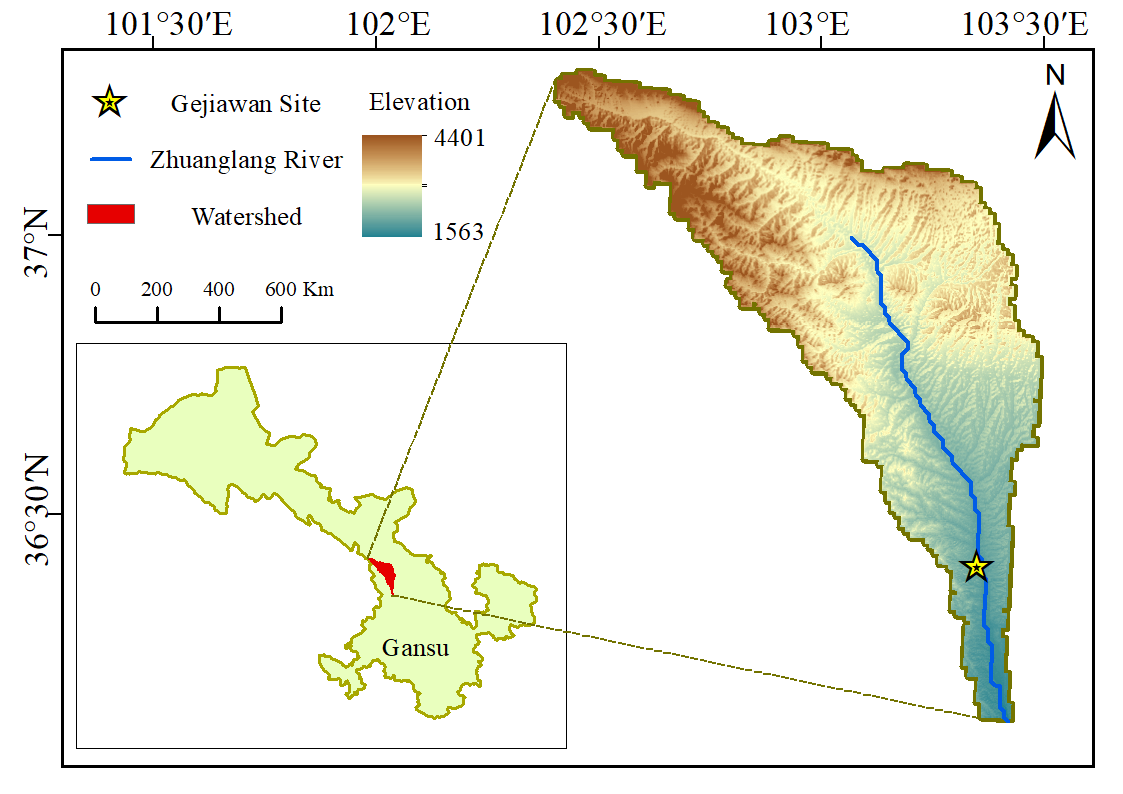
The Zhuanglang River is an important tributary of the upper Yellow River. It originates from the southern foothills of the Lenglong Ridge, an offshoot of the Qilian Mountains, and runs generally in a northwest–southeast direction through the central region of Gansu Province. Its drainage area covers several counties, including Tianzhu Tibetan Autonomous County and Yongdeng County, with a total length of approximately 179 kilometers.
The Zhuanglang River Basin (see Figure 1) features a complex and varied terrain. The upper reaches are dominated by high mountains and deep gorges, with significant elevation changes and fast-flowing streams; the middle and lower reaches gradually transition into river valley plains, where the land is relatively flat and open, forming fertile river terraces. The basin covers a total area of about 4,008 square kilometers. The climate belongs to the temperate continental type, with relatively low precipitation. Nevertheless, the Zhuanglang River and its numerous tributaries provide a relatively stable water supply, nourishing the land on both banks and making this an important agricultural region that nurtured a rich prehistoric civilization [1]. Historically, the Zhuanglang River Basin has been a significant corridor linking the Central Plains to the Hexi Corridor and the Qinghai-Tibet Plateau, giving it notable strategic importance. Since ancient times, it has been an area of multiethnic settlement, communication, and integration, where diverse cultures intersected and blended, forming a distinctive and pluralistic regional culture.
2. Site overview
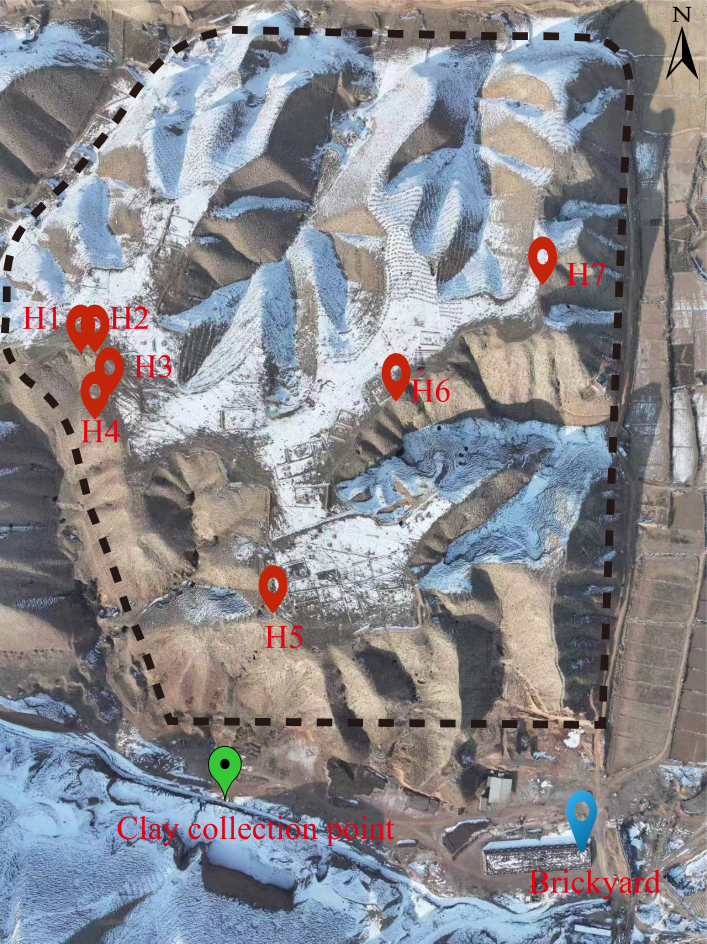
The Gejiawan site (see Figure 2) is a Neolithic site located on a second-level terrace on the west side of the Zhuanglang River within Yongdeng County. It is situated on a platform approximately 500 meters west of Gejiawan in Yushan Village, Hongcheng Town, Yongdeng County. The site lies about 1,200 meters southeast of Yushan Village, adjacent to the Shagou gully of Gejiawan to the south, and about 1,000 meters east of the Zhuanglang River, with a relative elevation of roughly 80 meters. Its coordinates are N36°27'16", E103°22'15", and its elevation is 1,883 meters above sea level. The site covers an area of roughly 400 meters from east to west and 300 meters from north to south, totaling about 120,000 square meters [4]. This investigation included a comprehensive survey of the terrace where the site is located. The terrace surface is relatively flat, with a modern cemetery in the central part, and several gullies of varying sizes surrounding it. Pottery sherds and lithic artifacts are scattered across the terrace surface.
3. Survey findings
3.1. Discovery of remains
Because the terrace where the site is located contains a large number of modern graves, this survey was limited to a comprehensive surface reconnaissance, with intensive field investigation focused on the site’s peripheral profiles. A total of seven archaeological features were identified, all of which are ash pits. Starting from the northwest corner of the terrace, these features are distributed along the edge of the site and numbered sequentially as H1, H2, H3, H4, H5, H6, and H7. A total of ten lithic artifacts were collected from these ash pits (see Figure 3).
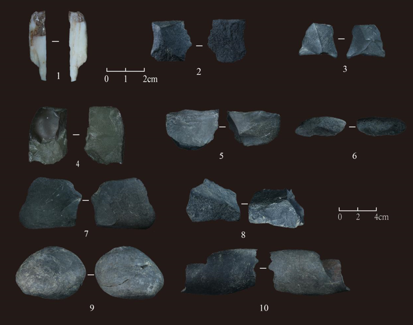
1.2025YGH1: 1, Personal ornament; 2.2025YGH7:1, Serrated tool; 3.2025YGH2: 2, Fragment; 4.2025YGH1: 2, Flake; 5.2025YGH2: 1, Single-platform core ; 6.2025YGH5: 2, Block fragment; 7.2025YGH5: 1, Flake; 8.2025YGH4: 1, Dual-platform core ; 9.2025YGH6: 2, Cobble ; 0.2025YGH6: 1, Dual-platform core
H1: N36°27'21.63", E103°22'8.83", elevation: 1,887 m. Located at the northwestern edge of the terrace, this pit opens below the disturbed soil layer, at a depth of 0.4–1 m from the ground surface. The profile is nearly circular, approximately 0.6 m in length and 0.6 m in thickness. The fill is relatively loose and grayish-brown. Based on the profile, the deposits can be divided into three layers: Layer 1: Loose, dark gray soil, 0–20 cm thick. Layer 2: Loose, lighter-colored soil, grayish-white, 20–40 cm thick. Layer 3: Loose, grayish-brown soil, containing abundant charcoal particles, animal bones, and pottery sherds. Artifacts collected include: One milky-white fragment, possibly jade, showing traces of workmanship; length 35.11 mm, width 8.98 mm, thickness 3.73 mm. Six pottery sherds: five are sand-tempered gray pottery with soot on the surface, likely utilitarian vessels, with similar characteristics suggesting they may belong to the same jar; one is a sand-tempered red pottery base fragment, with clear coil-building marks. One lithic artifact: a quartzite flake produced by hard-hammer direct percussion, relatively complete, with clear bulb of percussion and fracture lines. Two animal bone fragments. At 0.8 m from the edge of H1, a malachite fragment was discovered below the pit. The piece is relatively regular in shape and edges, with clear grinding traces; remaining length about 2.7 cm, width 1.52 cm, thickness 0.38–0.42 cm.
H2: N36°27'21.54", E103°22'8.90". Located 2 meters east of H1, this pit opens below the disturbed soil layer, at a depth of 1–1.6 m from the ground surface. The profile is strip-shaped, approximately 2.5 m long and 0.6 m wide. Based on the profile, the ash pit can be divided into four layers: Layer 1: Relatively compact, gray-white soil, containing a small amount of baked soil particles, pottery sherds, and other materials. Layer 2: Loose, gray-white sandy soil. Layer 3: Relatively compact, grayish-brown mottled soil, containing abundant baked soil, charcoal fragments, pottery sherds, and calcined bones. Layer 4: Loose, gray-white sandy soil, similar in texture to Layer 2. Artifacts collected from the pit include: Five pottery sherds: two sand-tempered gray pottery, including one jar rim with coil-building and slow-wheel finishing traces; three sand-tempered red pottery sherds, one of which has a yellowish-white slip. Two lithic artifacts: a quartzite single-platform core and one flake fragment, both produced by hard-hammer direct percussion. Two fragments of calcined animal bone.
H3: N36°27'21.00", E103°22'9.47". Located 20 meters southeast of H2, on the western edge of the site terrace. The pit opens below the disturbed soil layer, at a depth of 0.5–1 m from the ground surface. The profile is circular, approximately 1 m long and 1 m wide. The deposit can be divided into three layers: Layer 1 (0–15 cm): Loose, yellowish-brown soil. Layer 2 (15–30 cm): Loose, grayish-brown soil, containing abundant charcoal fragments and pottery sherds. Layer 3 (30–50 cm): Loose, yellowish-brown soil. Artifacts collected: One sand-tempered gray pottery sherd, a jar rim fragment with handle and stamped decoration; the interior wall shows slow-wheel finishing marks, and the surface has soot, suggesting it was a utilitarian vessel.
H4: N36°27'20.66", E103°22'9.35", elevation 1,883 m. Located 5 meters south of H3, on the western edge of the site terrace. The ash pit opens below the disturbed soil layer, at a depth of 1.2–1.8 m from the ground surface. The pit is roughly circular, about 1 m in width, and can be divided into two layers: Layer 1: Relatively compact, yellowish-brown soil, containing abundant charcoal fragments, animal bones, pottery sherds, and lime particles. Layer 2: Relatively compact, yellow-gray soil, containing a small amount of charcoal fragments. Artifacts collected: Three pottery sherds: two clay-based orange-yellow painted pottery with black and red broad-band decoration; the interior walls show slow-wheel finishing marks, and the vessels were likely jars, one of which has a handle; one sand-tempered gray pottery sherd, interior wall also showing slow-wheel finishing marks and surface soot, likely a utilitarian vessel fragment (body sherd). One lithic artifact: a dual-platform quartzite core, with flat platforms and clear flake scars, produced by hard-hammer direct percussion. One fragment of animal bone, species indeterminate.
H5: N36°27'16.23", E103°22'14.04", elevation 1,875 m. Located 100 meters southwest of H4, on the western edge of the site terrace. The ash pit opens below the disturbed soil layer, at a depth of 1.1–1.6 m from the ground surface. The profile is roughly circular, approximately 0.5 m long and 0.6 m wide, and can be divided into two layers: Layer 1 (0–30 cm): Loose, grayish-brown soil, containing abundant charcoal fragments, pottery sherds, animal bones, and lithic artifacts. Layer 2 (30–50 cm): Loose, gray-green soil, containing a small amount of charcoal fragments and white ash. Artifacts collected: Pottery sherds (7 pieces): Two clay-based orange-yellow painted pottery sherds: one decorated with red banded stripes and coated with white slip; the other with alternating black and red banded stripes. Five sand-tempered pottery sherds: one sand-tempered gray pottery with white slip and surface soot; four sand-tempered red pottery, two with white slip, one showing slow-wheel finishing marks, and one with observable coil-building traces. Lithic artifacts (2 pieces): one complete quartzite flake with distinct percussion point and conchoidal fracture lines; one broken quartz sandstone fragment with traces of burning. Both produced by hard-hammer direct percussion. Animal bone: one fragment, species indeterminate.
H6: N36°27'20.91", E103°22'17.23", elevation 1,876 m. Located 300 meters southeast of H5, on the eastern edge of the site terrace. The ash pit opens below the disturbed soil layer, at a depth of 1.2–1.45 m from the ground surface. The pit is strip-shaped, approximately 1.6 m long and 0.25 m thick, and can be divided into three layers: Layer 1 (0–10 cm): Loose, gray-green soil, containing pottery sherds, animal bones, lithic artifacts, and lime particles. Layer 2 (10–15 cm): Loose, yellow-gray sandy soil. Layer 3 (15–25 cm): Loose, grayish-brown soil, containing abundant charcoal fragments, lithic artifacts, and pottery sherds. Artifacts collected: Pottery sherds (14 pieces): all sand-tempered red pottery; one jar rim with soot and applied relief decoration, and four other sherds with surface soot, all exhibiting carbon-permeation firing; six sherds coated with yellowish-white slip, two with white encrustation; one painted pottery sherd decorated with black banded stripes. Lithic artifacts (2 pieces): one dual-platform core and one additional piece, both showing traces of burning. Animal bone: one fragment, species indeterminate.
H7: N36°27'23.04", E103°22'20.87", elevation 1,873 m. Located 300 meters northeast of H6, on the eastern edge of the site terrace. The ash pit opens below the disturbed soil layer, at a depth of 3.4–3.6 m from the ground surface. The pit is strip-shaped, approximately 0.4 m long and 0.2 m thick. No distinct layers are observed in the profile. The soil is relatively compact and yellow in color, containing a small amount of baked soil particles, charcoal fragments (baked soil and charcoal interspersed), gravel, pottery sherds, and lithic artifacts. Artifacts collected: Pottery sherd (1 piece): sand-tempered red pottery, vessel type indeterminate, showing slow-wheel finishing marks. Lithic artifact (1 piece): serrated tool made of quartz sandstone, with three small retouch scars on the left side and sharp serrated edges.
3.2. Artifact collection
3.2.1. Lithic artifacts
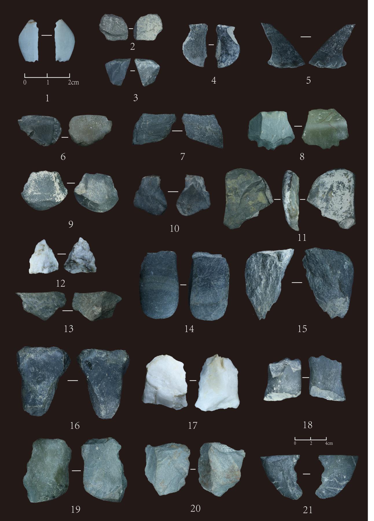
A total of 169 lithic artifacts were collected from the site, including 10 from archaeological features and 159 from the surface (partial, see Figure 4). The types include personal ornaments, stone tools, cores, flakes, and fragments. The raw materials are predominantly quartzite (45.56%), followed by quartz sandstone (30.77%), chert (18.34%), with minor amounts of vein quartz (4.7%) and malachite (0.59%). The surfaces of the lithic artifacts show little abrasion, with minor weathering and water erosion.
3.2.1.1. Ground stone artifacts
A total of three ground stone artifacts were collected, accounting for 1.8% of all lithic artifacts. Among them, two are vein quartz and one is malachite: 2025YGH1:1: Excavated from H1; vein quartz, showing clear finishing marks, produced by grinding; length 35.11 mm, width 8.98 mm, thickness 3.73 mm, weight 1.944 g. Well-shaped and finely worked, possibly a prehistoric jade artifact. 2025YGB:1: Surface find; malachite, showing clear finishing marks, produced by grinding; length 26.87 mm, width 15.08 mm, thickness 4.34 mm, weight 2.698 g. Well-shaped and finely worked, possibly a prehistoric ornament. 2025YGB:2: Surface find; vein quartz, showing clear finishing marks, produced by grinding; length 18.44 mm, width 8.63 mm, thickness 2.86 mm, weight 0.802 g. Well-shaped and finely worked, possibly a prehistoric jade artifact, similar to 2025YGH1:1. All three artifacts are fragments, and their complete forms are indeterminate, but all are finely manufactured and should be regarded as prehistoric ornaments.
3.2.1.2. Percussion-flaked stone artifacts
A total of nine percussion-flaked stone artifacts were collected, accounting for 3.6% of all lithic artifacts. All are made of quartzite: 2025YGH7:1: Excavated from H7; dark gray quartzite serrated tool; length 23.15 mm, width 23.34 mm, thickness 9.09 mm, weight 4.852 g. The edge is on the left side of the flake, edge length 14.21 mm, with three evenly distributed small retouch scars. Use-wear is not apparent. Manufactured using a single-layer, unidirectional technique, edge angle 107°–130°. 2025YGB:3: Surface find; light gray quartzite scraper; length 74.76 mm, width 38.1 mm, thickness 5.27 mm, weight 16.136 g. The edge is at the distal end of the flake, edge length 47.41 mm, with clear retouch scars. Use-wear is minimal. Manufactured using a single-layer, bidirectional technique, edge angle 70°–79°. 2025YGB:4: Surface find; dark gray quartzite scraper; length 54.59 mm, width 31.2 mm, thickness 4.75 mm, weight 10.276 g. Edge on left side of the flake, edge length 54.6 mm, with clear retouch scars. Use-wear is minimal. Single-layer, bidirectional manufacture; edge angle 72°–140°. 2025YGB:5: Surface find; dark gray quartzite chopping tool; length 83.37 mm, width 48.92 mm, thickness 22.77 mm, weight 153.747 g. Fracture points concentrated at the distal and right portions of the fragment, showing fish-scale pattern. Percussion marks and use-wear are clearly visible. 2025YGB:6: Surface find; yellow-green quartzite chopping tool; length 76.85 mm, width 60.82 mm, thickness 17.49 mm, weight 108.313 g. Fracture points distributed continuously along the fragment, percussion marks obvious, use-wear relatively evident. 2025YGB:7: Surface find; dark gray quartzite scraper; length 50.52 mm, width 32.84 mm, thickness 9.65 mm, weight 20.64 g. Edge on left side of the flake, edge length 31.46 mm, curved inward. Use-wear evident. Single-layer, bidirectional manufacture; edge angle 106°–116°. 2025YGB:8: Surface find; gray quartzite scraper; length 54.31 mm, width 39.25 mm, thickness 14.56 mm, weight 25.366 g. Edge at distal end of flake, edge length 37.59 mm, curved outward. Use-wear evident. Single-layer, unidirectional manufacture; edge angle 121°–125°. 2025YGB:9: Surface find; dark gray quartzite scraper; length 43.45 mm, width 34.85 mm, thickness 8.96 mm, weight 10.739 g. Edge on distal and left sides, likely a double-edged tool; left edge 32 mm, distal edge 33.36 mm. Use-wear minimal; retouch evident. Single-layer, bidirectional manufacture; edge angle 92°–94°. 2025YGB:10: Surface find; dark gray quartzite concave-edged tool; length 57.56 mm, width 48.29 mm, thickness 19.76 mm, weight 55.715 g. Edge on right-left side of fragment, with two consecutive, evenly sized notches; edge length 23.77 mm. Use-wear minimal; retouch evident. Single-layer, unidirectional manufacture; edge angle 116°–135°.
3.2.1.3. Stone cores
A total of 30 stone cores were collected, accounting for 17.75% of all lithic artifacts. All are hammer-struck cores and can be classified into single-platform, dual-platform, multi-platform, and discoidal cores. Raw materials include 6 chert, 14 quartzite, 8 quartz sandstone, and 2 vein quartz. Dimensions: length 35.48–84.35 mm (mean 60.449 mm), width 25.54–59.71 mm (mean 44.193 mm), thickness 12.39–54.98 mm (mean 28.691 mm), weight 17.149–318.731 g (mean 92.334 g). Platform angles range from 26°–147° (mean 93.6°).
Single-Platform Cores: 3 pieces, 10% of stone cores. Two quartzite, one quartz sandstone. 2025YGH2:1: Excavated from H2; original material dark gray quartzite cobble. Produced by hard-hammer direct percussion; length 55.39 mm, width 36.99 mm, thickness 20.55 mm, weight 48.712 g. Platform is natural, platform angles 98° and 113°.
Dual-Platform Cores: 23 pieces, 76.7% of stone cores. Five chert, ten quartzite, six quartz sandstone, two vein quartz. Two from archaeological features, others from surface collection. 2025YGH4:1: Excavated from H4; original material dark gray quartzite cobble. Produced by hard-hammer direct percussion; length 54.72 mm, width 46.64 mm, thickness 28.52 mm, weight 73.685 g. Platforms include natural and prepared surfaces; platform angles 93°–115°, mean 105.7°. 2025YGH6:1: Excavated from H6; original material dark gray quartzite cobble. Produced by hard-hammer direct percussion; length 82.79 mm, width 46.36 mm, thickness 29.11 mm, weight 141.105 g. Platform is natural; platform angles 73°–138°, mean 103°.
Multi-Platform Cores: 3 pieces, 10% of stone cores. One chert, one quartzite, one quartz sandstone. 2025YGB:34, 2025YGB:35, 2025YGB:36: Surface finds, produced by hard-hammer direct percussion; lengths 39.94 mm, 64.17 mm, 67.7 mm; widths 46.36 mm, 50.46 mm, 57.11 mm; thicknesses 22.61 mm, 19.65 mm, 33.17 mm; weights 56.506 g, 61.873 g, 127.149 g. Platforms include natural and prepared surfaces; platform angles 59°–147°, mean 98.2°.
Discoidal Core: 1 piece, 3.3% of stone cores. Quartzite. 2025YGB:37: Single-sided discoidal core, produced by hard-hammer direct percussion; length 62 mm, width 54.96 mm, thickness 25.53 mm, weight 102.356 g. Prepared platform; four complete flake scars radiating centripetally; platform angles 78°, 145°, 88°, and 87°, mean 99.5°.
3.2.1.4. Flakes
A total of 84 flakes were collected, accounting for 49.7% of all lithic artifacts. They are classified as complete flakes and incomplete flakes.
Complete Flakes: 46 pieces, 54.8% of all flakes. All are hammer-struck flakes: 8 chert, 22 quartzite, 15 quartz sandstone, 1 vein quartz. Dimensions: length 16.21–73.36 mm (mean 42.455 mm), width 8.32–52.97 mm (mean 29.84 mm), thickness 2.58–24.27 mm (mean 11.55 mm), weight 0.643–62.863 g (mean 11.55 g). Platform types include natural platform, prepared platform, and punctuated platform: 33 natural platforms (71.74%), 5 prepared platforms (10.87%), 8 punctuated platforms (17.39%). Flake angles range 30°–155° (mean 100.5°); exterior platform angles 39°–142° (mean 90.7°).
Incomplete Flakes: 38 pieces, 45.2% of all flakes: 8 chert, 18 quartzite, 11 quartz sandstone, 1 vein quartz. Dimensions: length 13.74–54.26 mm (mean 37.825 mm), width 10.97–50.84 mm (mean 25.833 mm), thickness 2.61–21.73 mm (mean 9.893 mm), weight 0.464–31.649 g (mean 10.583 g).
3.2.1.5. Fragments
A total of 43 fragments were collected, accounting for 25.4% of all lithic artifacts. Raw materials include 9 chert, 14 quartzite, 17 quartz sandstone, and 2 vein quartz. Dimensions: length 18.89–71.69 mm (mean 44.134 mm), width 14.18–62.24 mm (mean 29.76 mm), thickness 7.05–40.43 mm (mean 16.902 mm), weight 2.326–197.144 g (mean 25.295 g). Notably, 2025YGH5:2 and 2025YGH6:2 show clear evidence of burning.
3.2.2. Pottery shards
A total of 166 pottery shards were collected from the site: 37 from archaeological features and 129 from surface collection. Among them: 80 red sand-tempered pottery shards, accounting for 48.19%. 15 red clay pottery shards, 9.04%. 36 gray sand-tempered pottery shards, 21.69%. 36 painted pottery shards, 21.69%. Identifiable vessel forms from surface collection include double-handled jars, wide-mouthed jars, belly-handled jars, and bowls. Decorative motifs observed include applied raised decoration, mat impressions, punctate patterns, coarse cord impressions, strip patterns, wavy lines, meanders, zigzags, and bagua motifs. Based on the typological features and decorative patterns of the collected specimens, and through comparison with contemporary typical artifacts from surrounding areas, the cultural affiliation of the site is determined to be Majiayao Culture, Machang type.
4. Discussion
4.1. Sources of lithic and pottery raw materials
The Gejiawan site is situated on a secondary terrace on the west side of the Zhuanglang River. The terrace edge is steep, and the stratigraphy is clearly distinguishable. The lowermost layer consists of a gravel stratum formed during the terrace’s development, providing a natural base for the production of lithic artifacts. Systematic collection and analysis indicate that quartzite constitutes the majority of lithic raw materials at the site (45.56%), followed by quartz sandstone (30.77%) and chert (18.34%). Minor materials include vein quartz (4.7%) and malachite (0.59%). These primary raw materials—quartzite, quartz sandstone, chert, and vein quartz—are widely distributed in the nearby Zhuanglang River alluvial flats and within the gravel layer of the secondary terrace where the site is located. This abundant natural resource made it highly convenient for prehistoric inhabitants to obtain lithic materials.
To the south of the Gejiawan terrace, a modern brick factory is currently present. The clay used by the factory is sourced from a nearby river gully, located at the southwestern edge of the site’s terrace. The clay is reddish-brown, relatively pure, and can be directly used for pottery production after preliminary processing. Considering the characteristics and geographical location of this clay source, it is highly likely that this area served as an important raw material source for prehistoric pottery production, providing key evidence for understanding prehistoric ceramic technology.
4.2. Site function and subsistence patterns
The edges of the Gejiawan site contain numerous ash pits, from which pottery shards, lithic artifacts, and burnt bones were recovered. In addition to the abundant lithic artifacts, the terrace also yielded a rich assemblage of pottery shards, some showing traces of soot and other use-wear. This evidence indicates that the prehistoric inhabitants of Gejiawan made extensive use of stone tools and ceramics, suggesting that the site functioned as a residential settlement. The use of pottery and ground stone tools demonstrates that the Machang-type inhabitants during this period were settled at the site and that craft technologies were well developed. The community possessed both a specialized ceramic production system and refined lithic manufacturing techniques. Technologically, the Machang inhabitants were proficient in grinding, knapping, and composite tool production. The differentiation and combination of these techniques not only met the demands of dry-land agricultural production for durable and efficient tools but also supported the mobility and versatility required for foraging and hunting activities.
5. Conclusion
The Gejiawan site is located on a terrace on the west side of the Zhuanglang River, with an elevation difference of approximately 100 m between the terrace and the river. The terrace surface is relatively high and generally flat, and the cultural layer is shallowly buried. Based on the characteristics of the collected pottery shards and information from the Third National Cultural Relics Survey conducted by the Gansu Provincial Institute of Cultural Relics and Archaeology, the site is attributed to the Neolithic Majiayao Culture, Machang type, representing the mainstream prehistoric cultural type in this region. Unlike other contemporaneous Machang-type sites in the area, Gejiawan has yielded a significantly larger quantity of lithic artifacts. Both knapped and ground stone tools coexist at the site, and some lithic artifacts display fine workmanship resembling personal ornaments, highlighting the site’s prominent status in the region. The concurrent production and use of pottery and lithic tools, together with agricultural activities and craft processing, fully illustrate the complex subsistence and production pattern characteristic of the Machang-type Majiayao Culture.
Funding
This paper represents the phased results of the Gansu Provincial Social Science Planning Project “Research on Prehistoric Handicraft Technology and Regional Cultural Development in the Gan-Qing Area” (2024YB043), the Gansu Provincial Education and Science & Technology Innovation Project “Study on Prehistoric Pottery Technology and East–West Interaction of Regional Handicraft Technology in the Datong River–Zhuanglang River Basin” (2024A-014), and the Northwest Normal University 2024 Graduate Research Funding Project “Survey and Analysis of the Gejiawan Site in the Zhuanglang River Basin” (2024CXZX-LXS011).
References
[1]. Xu, W. (2019). Zhuanglang River Basin water resources assessment and water resources carrying capacity (Master’s thesis, Lanzhou University).
[2]. Gansu Provincial Institute of Cultural Relics and Archaeology. (2011). Prehistoric archaeological survey report of the Hexi Corridor (pp. 412–427). Beijing: Cultural Relics Press.
[3]. Zhang, P., Yang, Y. S., Zhang, S. J., & Yang, X. Y. (2025). Late Neolithic settlement location and prediction in the northeastern Tibetan Plateau: A case study of the Zhuanglang River Basin.Quaternary Research, 1, 267–282.
[4]. Gansu Provincial Institute of Cultural Relics and Archaeology. (2023). Prehistoric archaeological survey in areas near the left bank of the Yellow River in Gansu (pp. 104–108). Lanzhou: Gansu Education Press.
Cite this article
Zhang,X.;Xu,S.;Mu,Z.;Tan,F.;Shen,X. (2025). A brief survey report on the Gejiawan Site in the Zhuanglang River Basin. Advances in Humanities Research,12(5),122-130.
Data availability
The datasets used and/or analyzed during the current study will be available from the authors upon reasonable request.
Disclaimer/Publisher's Note
The statements, opinions and data contained in all publications are solely those of the individual author(s) and contributor(s) and not of EWA Publishing and/or the editor(s). EWA Publishing and/or the editor(s) disclaim responsibility for any injury to people or property resulting from any ideas, methods, instructions or products referred to in the content.
About volume
Journal:Advances in Humanities Research
© 2024 by the author(s). Licensee EWA Publishing, Oxford, UK. This article is an open access article distributed under the terms and
conditions of the Creative Commons Attribution (CC BY) license. Authors who
publish this series agree to the following terms:
1. Authors retain copyright and grant the series right of first publication with the work simultaneously licensed under a Creative Commons
Attribution License that allows others to share the work with an acknowledgment of the work's authorship and initial publication in this
series.
2. Authors are able to enter into separate, additional contractual arrangements for the non-exclusive distribution of the series's published
version of the work (e.g., post it to an institutional repository or publish it in a book), with an acknowledgment of its initial
publication in this series.
3. Authors are permitted and encouraged to post their work online (e.g., in institutional repositories or on their website) prior to and
during the submission process, as it can lead to productive exchanges, as well as earlier and greater citation of published work (See
Open access policy for details).
References
[1]. Xu, W. (2019). Zhuanglang River Basin water resources assessment and water resources carrying capacity (Master’s thesis, Lanzhou University).
[2]. Gansu Provincial Institute of Cultural Relics and Archaeology. (2011). Prehistoric archaeological survey report of the Hexi Corridor (pp. 412–427). Beijing: Cultural Relics Press.
[3]. Zhang, P., Yang, Y. S., Zhang, S. J., & Yang, X. Y. (2025). Late Neolithic settlement location and prediction in the northeastern Tibetan Plateau: A case study of the Zhuanglang River Basin.Quaternary Research, 1, 267–282.
[4]. Gansu Provincial Institute of Cultural Relics and Archaeology. (2023). Prehistoric archaeological survey in areas near the left bank of the Yellow River in Gansu (pp. 104–108). Lanzhou: Gansu Education Press.