


1. Introduction
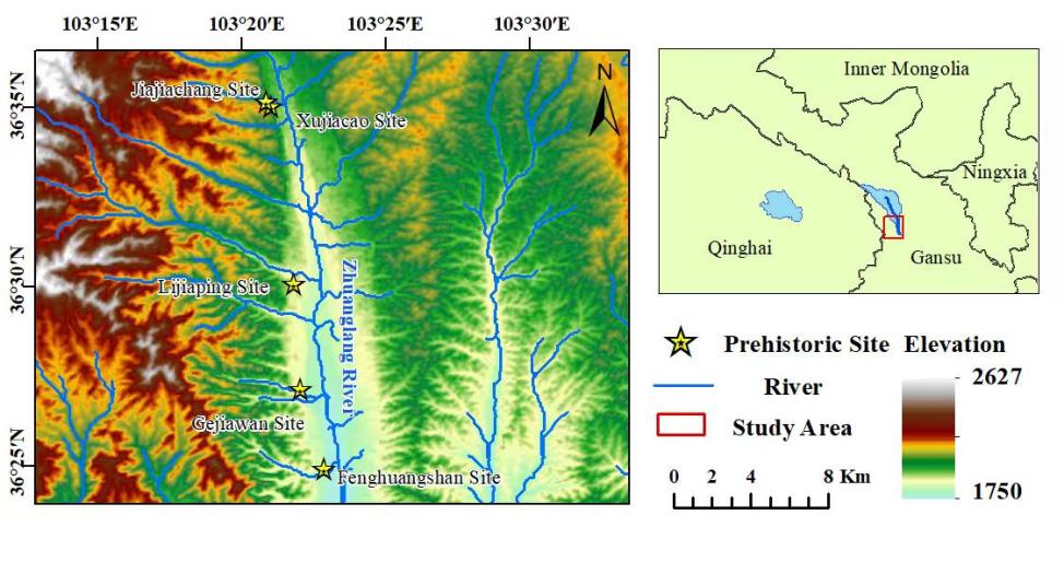
The Zhuanglang River Basin (ZRB) is located in the transitional zone between the northeastern Tibetan Plateau and the Loess Plateau of Longxi, with geographical coordinates ranging from 36°12′55″ to 36°56′36″ N and 102°57′22″ to 103°38′38″ E. The river originates from the southern slope of the Lenglongling Mountains, flows from north to south through the entirety of Yongdeng County, and eventually joins the main course of the Yellow River via the Huangshui River [1]. Based on topographical features, the river can be divided into four typical sections: the upper Fuqiangpu Gorge section, the middle Yongdeng wide-valley section, the lower Yehucheng-Kushui Gorge section, and the estuarine gorge section. Among these, the Yongdeng wide-valley section extends approximately 50 km and belongs to a typical temperate arid climate zone, with an annual average temperature of 5.9°C and total annual precipitation of only 339 mm [2]. The overall terrain is characterized by a north-high, south-low gradient, with a pronounced depression-type valley morphology formed under the uplift influence of adjacent mountains.
From a hydrogeological perspective, the main channel exhibits stable perennial runoff, whereas tributaries are mostly seasonal streams. Influenced by neotectonic movements, multi-level river terraces have developed within the basin. Together with the surrounding loess ridges and hills, these form a complex geomorphological assemblage that provided an ideal habitat for early human activities. Archaeological evidence indicates that the region preserves a complete sequence of prehistoric cultural development, including the Majiayao Culture (ca. 4,800-4,600 BP), Banshan Culture (ca. 4,500-4,300 BP), Machang Culture (ca. 4,200-4,000 BP), Qijia Culture (ca. 4,100-3,900 BP), and Xindian Culture (ca. 3,600-3,500 BP) [3-5]. This continuous accumulation of cultural layers, along with the co-evolution of local geomorphology and ecosystems, provides an important case study for exploring human-environment interactions in the upper Yellow River region during prehistoric times. This study focuses on the middle and lower reaches of the river, selecting representative Neolithic sites with stone artifacts discovered during field surveys. By analyzing lithic production techniques, it aims to explore ancient subsistence strategies and social development characteristics in the region (see Figure 1).
2. Site overview
In 2024, during the team’s survey of prehistoric sites in the Zhuanglang River Basin (ZRB), stone artifacts were collected from several sites. The artifacts are rich and diverse, including stone axes, stone knives, stone sickles, as well as scrapers, pointed tools, cores, flakes, and broken fragments. The lithic technologies comprise both percussion and ground stone techniques. The surveyed sites include the Gejiawan Site, Lijiaping Site, Jiajiachang Site, Xujia Caogou Site, and Fenghuangshan Site—five Late Neolithic sites in total—with their cultural attribution identified as Machang Culture.
Gejiawan Site: The Gejiawan Site is located on a terrace approximately 500 meters west of Gejiawan in Yushan Village, Hongcheng Town, Yongdeng County. It lies about 1,000 meters east of the Zhuanglang River, with a relative height of approximately 80 meters and an elevation of 1,883 meters. The site extends roughly 400 meters east-west and 300 meters north–south, covering an area of about 120,000 m². Its cultural attribution is Machang Culture, and the artifacts date to 4,200-4,000 BP [6].
Lijiaping Site: The Lijiaping Site is located approximately 200 meters west of Huajianzi in Yangjiaying Village, Longquansi Town, Yongdeng County, on a terrace south of Feijia Mountain Gully. It is about 900 meters east of the Zhuanglang River, with a vertical difference of roughly 40 meters and an elevation of 1,897 meters. The site extends approximately 700 meters east–west and 800 meters north–south, covering an area of about 560,000 m². Its cultural attribution is Machang Culture, with artifacts dating to 4,100-3,900 BP [6].
Jiajiachang Site: The Jiajiachang Site is situated west of Jiajiachang Village, Datong Town, Yongdeng County, on a ridge south of Jiajiachang Sand Gully. It is about 850 meters east of the Zhuanglang River, with a relative height of approximately 50 meters and an elevation of 1,977 meters. The site measures roughly 100 meters east–west and 80 meters north-south, covering an area of about 8,000 m². Its cultural attribution is Machang Culture, with artifacts dating to 4,100-3,900 BP [6].
Xujia Caogou Site: The Xujia Caogou Site is located approximately 1,000 meters northwest of Xujia Caogou, Jiajiachang Village, Datong Town, Yongdeng County, on a terrace west of the now-abandoned Datong No. 2 Brick Factory. It lies about 850 meters east of the Zhuanglang River, with a relative height of approximately 85 meters and an elevation of 2,011 meters. The site extends roughly 250 meters east-west and 130 meters north–south, covering an area of about 32,000 m². Its cultural attribution is Machang Culture [6].
Fenghuangshan Site: The Fenghuangshan Site is situated approximately 500 meters west of Tuojiazhuang, Fengshan Village, Hongcheng Town, Yongdeng County, on Fenghuangshan, a second-level terrace on the west bank of the Zhuanglang River. The site has a relative height of about 60 meters and covers an area of approximately 45,000 m². The terrain slopes from west to east in a stepped manner, exposing features such as ash pits and ash layers. The cultural layer is 2.5 meters thick, located 0.8 meters below the surface. Collected specimens include stone artifacts and pottery sherds. The cultural attribution is Machang Culture [6].
Both domestic and international research on Machang Culture has produced relatively abundant results regarding chronology and painted pottery studies (e.g., Ren Ruibo’s exploration of Machang Culture chronology and the Yangshan cemetery phenomenon). Research on stone artifacts has long been dominated by typological analysis, while systematic interpretation of artifact function and human subsistence patterns remains insufficient. This study takes representative Machang Culture sites in the Zhuanglang River Basin (including the Gejiawan, Lijiaping, Jiajiachang, Xujia Caogou, and Fenghuangshan sites) as its research objects. By constructing an integrated research framework of “stone artifact functional chain–environmental resource system—human behavioral patterns,” and employing traditional lithic research methods such as typological classification (percussion and ground stone tools) and use-wear analysis, this study analyzes prehistoric resource utilization and contemporary socio-economic structures. It focuses on the production and use chains of stone artifacts to elucidate the corresponding human behavioral patterns, thereby revealing regional characteristics and the evolution of subsistence strategies in the Machang Culture of the Zhuanglang River Basin.
3. Types of stone artifacts
|
Stone tool types |
Quartzite |
Quartz Sandstone |
Siliceous Rock |
Vein Quartz |
Slate |
Total |
Percentage |
|
|
Ground Stone Tools |
Stone Knife (Fragmentary) |
1 |
1 |
2.50% |
||||
|
Double-Holed Stone Knife (Fragmentary) |
1 |
1 |
2.50% |
|||||
|
Chipped Stone Tools |
Chopper |
1 |
1 |
2.50% |
||||
|
Scraper |
4 |
1 |
5 |
12.50% |
||||
|
Point |
1 |
1 |
2.50% |
|||||
|
Denticulate |
1 |
1 |
2.50% |
|||||
|
Hammerstone |
1 |
1 |
2.50% |
|||||
|
Core Types |
Multi-platform Core |
1 |
1 |
2.50% |
||||
|
Flake Types |
Percussion Flake |
12 |
4 |
3 |
19 |
47.50% |
||
|
Chunks and Fragments |
6 |
2 |
1 |
9 |
22.50% |
|||
|
Total |
27 |
6 |
4 |
1 |
2 |
40 |
100.00% |
|
|
Percentage |
67.50% |
15.00% |
10.00% |
2.50% |
5.00% |
100.00% |
A total of 41 stone artifacts were collected in this survey, including 38 from surface collection and 3 from archaeological features. Among these, 23 specimens were from the Gejiawan Site, 12 from the Lijiaping Site, three from the Jiajiachang Site, two from the Xujia Caogou Site, and one from the Fenghuangshan Site. The types include Ground Stone Tools, Chipped Stone Tools, Multi-platform Cores, Percussion Flakes, and Chunks and Fragments. The raw materials are dominated by quartzite (66%), followed by quartz sandstone (15%) and siliceous rock (12%), with minor occurrences of slate (5%) and vein quartz (2%). According to lithic production techniques, the collected stone artifacts can be divided into Ground Stone Tools and Chipped Stone Tools, with two Ground Stone Tools (5%) and 39 Chipped Stone Tools (95%) (see Table 1).
3.1. Percussion Flakes
A total of 19 Percussion Flakes were collected, accounting for 46% of all stone artifacts. All are percussion flakes, including 3 made of siliceous rock, 4 of quartz sandstone, and 12 of quartzite. Their lengths range from 24.56 to 71.87 mm, with an average of 44.19 mm; widths range from 23.94 to 67.85 mm, averaging 44.98 mm; thicknesses range from 7.09 to 22.86 mm, with an average of 13.45 mm; and weights range from 6.688 to 70.893 g, with an average of 27.887 g. The flake platform types can be divided into natural platforms and plain platforms, with 15 natural platforms (78.95%) and 4 plain platforms (21.05%) (see Figure 2).
3.2. Multi-platform Cores
A total of 1 Multi-platform Core was collected, accounting for 2% of all stone artifacts (2024ZLB: 8). It is a multi-platform core made of quartzite using hard-hammer direct percussion. Its length is 42.63 mm, width 64.05 mm, thickness 44.92 mm, and weight 112.152 g. The core exhibits both natural and plain platforms, with platform angles ranging from 81° to 143°, averaging 106.86° (see Figure 2).
3.3. Chunks and Fragments
A total of 10 Chunks and Fragments were collected, accounting for 24% of all stone artifacts. Among them, 1 is siliceous rock, 1 vein quartz, 2 quartz sandstone, and 6 quartzite. Their lengths range from 20.45 to 62.4 mm, with an average of 45.73 mm; widths range from 23.62 to 48.33 mm, averaging 36.23 mm; thicknesses range from 8.1 to 30.74 mm, with an average of 17.37 mm; and weights range from 4.09 to 82.105 g, with an average of 33.32 g (see Figure 2).
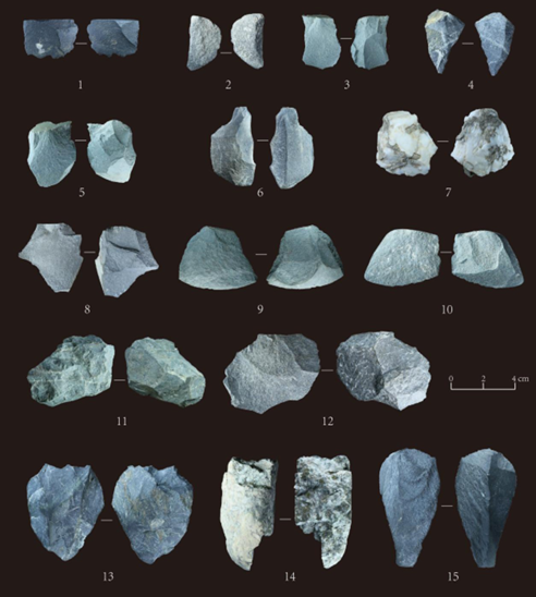
1.2024ZGB:9,Flake;2.2024ZLB:7,Flake;3.2024ZXB:1,Flake;4.2024ZGB:22,Chunk;5.2024ZFB:1,Flake;6.2024ZJB:2,Chunk;7.2024ZLB:9,Chunk;8.2024ZJB:1,Flake;9.2024ZGB:8,Flake;10.2024ZLB:5,Flake;;11.2024ZLB:8,Multi-platform Core;12.2024ZXB:2,Flake;13.2024ZGB:18,Chunk;14.2024ZLH2:2,Chunk;15.2024ZGB:10,Flake
3.4. Ground Stone Tools
A total of 2 Ground Stone Tools were collected, accounting for 5% of all stone artifacts. Both are made of slate and were collected from the Lijiaping Site; 2024ZLB: 1, Stone Knife (Fragmentary), surface collection from the Lijiaping Site. Length 77.2 mm, width 35.39 mm, thickness 2.17 mm, weight 6.292 g. Preserved edge length 47.66 mm, edge ground with clear grinding traces, processed by unidirectional grinding. 2024ZLB: 2, Double-Holed Stone Knife (Fragmentary), surface collection from the Lijiaping Site. Length 89.49 mm, width 37.76 mm, thickness 4.61 mm, weight 31.317 g. Preserved edge length 69.47 mm, fully ground with clear grinding traces. The upper right end of the blade has two circular perforations, diameter 4.2 mm (see Figure 3).
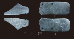
1.2024ZLB:1,Stone Knife (Fragmentary);2.2024ZLB:2,Double-Holed Stone Knife (Fragmentary)
3.5. Chipped Stone Tools
A total of 9 Chipped Stone Tools were collected, accounting for 22% of all stone artifacts; 2024ZGB: 1, Chopper, surface collection from the Gejiawan Site, made of quartzite, length 113.78 mm, width 45.34 mm, thickness 18.37 mm, weight 136.006 g, reshaped by hard-hammer percussion, clear use-wear traces, regular shape; 2024ZGB: 2, retouched scraper, surface collection from the Gejiawan Site, made of quartzite, length 43.6 mm, width 26.63 mm, thickness 11.61 mm, weight 14.599 g, raw material: long flake, produced by hard-hammer direct percussion, edge shows retouch traces, edge length 18.11 mm, clear use-wear traces; 2024ZGB: 3, Point, surface collection from the Gejiawan Site, made of quartzite, length 62.13 mm, width 50.14 mm, thickness 17.54 mm, weight 50.21 g, raw material: long flake, produced by hard-hammer direct percussion, edge shows retouch traces, edge lengths 62.24 mm, 38.99 mm, edge angle 74°, clear use-wear traces; 2024ZGB: 4, retouched scraper, surface collection from the Gejiawan Site, made of quartzite, length 56.98 mm, width 44.76 mm, thickness 17.43 mm, weight 58.563 g, raw material: long flake, produced by hard-hammer direct percussion, edge shows retouch traces, edge length 55.51 mm, clear use-wear traces; 2024ZGB: 5, retouched scraper, surface collection from the Gejiawan Site, made of quartzite, length 47.68 mm, width 52.26 mm, thickness 16.3 mm, weight 29.7 g, raw material: wide flake, produced by hard-hammer direct percussion, edge shows retouch traces, edge length 51 mm, clear use-wear traces; 2024ZLB: 3, retouched scraper, surface collection from the Lijiaping Site, made of siliceous rock, length 54.58 mm, width 51.86 mm, thickness 24.25 mm, weight 59.963 g, raw material: long flake, produced by hard-hammer direct percussion, edge shows retouch traces, edge length 57.27 mm, clear use-wear traces; 2024ZLB: 4, retouched scraper, surface collection from the Lijiaping Site, made of quartzite, length 39.91 mm, width 52.24 mm, thickness 15.91 mm, weight 34.29 g, raw material: wide flake, produced by hard-hammer direct percussion, edge shows retouch traces, edge length 42.8 mm, clear use-wear traces; 2024ZLH1: 1, Denticulate, collected from Lijiaping Site H1, made of quartzite, length 39.41 mm, width 45.83 mm, thickness 11 mm, weight 20.562 g, raw material: wide flake, produced by hard-hammer direct percussion, left end shows retouch traces forming a serrated edge, edge length 36.71 mm, clear use-wear traces; 2024ZLH2: 1, Hammerstone, collected from Lijiaping Site H2, made of quartzite, length 128.26 mm, width 40.69 mm, thickness 11 mm, weight 29.08 g, raw material: cobble, both ends show percussion traces, clear use-wear traces (see Figure 4).
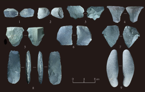
1.2024ZGB:2,retouched scraper;2.2024ZLH1:1,Denticulate;3.2024ZLB:4,retouched scraper;4.2024ZGB:5,retouched scraper;5.2024ZLB:3,retouched scraper;6.2024ZGB:4,retouched scraper;7.2024ZGB:3,Point;8.2024ZGB:1,Chopper;9.2024ZLH2:1,Hammerstone
4. Discussion
4.1. Technological features and functional analysis of stone artifacts
The raw materials of stone artifacts in the Zhuanglang River Basin are dominated by quartzite (66%), followed by quartz sandstone (15%) and siliceous rock (12%), with minor amounts of slate (5%) and vein quartz (2%). Surveys of raw material sources show that quartzite, quartz sandstone, siliceous rock, vein quartz, and slate can all be found in the riverbed and gravel layers of the terraces on both sides of the Zhuanglang River. Overall, these rock types are relatively homogeneous and of moderate hardness, sufficient to meet the requirements for stone artifact production. Based on the composition and types of stone artifacts, the initial conditions and targeted exploitation of different raw materials transported into the basin varied. Chipped stone tools were primarily made of quartzite, supplemented by quartz sandstone, siliceous rock, and vein quartz. The only two ground stone tools were made of slate, whose stratification and ease of grinding well suited the fine processing required for ground stone tool production. The coexistence of ground and chipped technologies in the surveyed artifacts indicates that during this period, the Machang communities of the Zhuanglang River Basin practiced dry-land agriculture with cutting and fire-making tools, supplemented by gathering and hunting to offset the effects of the Last Glacial Maximum on agricultural productivity.
4.2. Environmental basis of subsistence patterns
Settlement Location Characteristics: Proximity to water sources and avoidance of flooding by situating on terraces (e.g., most sites in the Zhuanglang River Basin are located on riverbank terraces). The five sites examined in this study are all situated on second-level terraces on the west side of the Zhuanglang River, within 500-1,000 meters of the river, with relative heights of 40-85 meters. The terraces are flat and open, providing a wide field of view. The proximity to water sources facilitated access to irrigation, fishing, hunting, and daily water use, while the river also enabled transportation and material exchange. In addition, terraces elevated above flood levels offered protection, with higher terraces benefiting from greater flood resistance, while the deep, fertile soils formed by river deposits provided a material basis for agriculture. Steep terrace edges also functioned as natural defensive barriers, creating a spatial pattern that integrated production, security, and comfort. This settlement strategy is grounded in the geographic mechanism of dynamic equilibrium between river erosion and deposition: intermittent crustal uplift caused river incision and the formation of stepped topography, while glacial–interglacial hydrological changes shaped the multi-level terrace structure. Higher terraces, being older, had significantly better flood control capabilities than lower terraces; lower terraces were closer to water sources, facilitating access to water for production and daily life. Therefore, balancing water accessibility with seasonal flood risk mitigation became a key factor influencing site selection during this period.
4.3. Regional characteristics and subsistence evolution of the Machang Culture
The Zhuanglang River Basin, as a key corridor connecting the Qinghai-Tibet Plateau and the Loess Plateau, served as an important channel for prehistoric cultural transmission and interaction. The Machang Culture represents a significant cultural type in the Late Neolithic of the Ganqing region, and research on its lithic technology and subsistence patterns is crucial for understanding the evolution of human-environment relationships in this area.
As an important Late Neolithic cultural type in northwest China’s Ganqing region, Machang Culture sites exhibit the coexistence of ground and chipped stone tools, revealing the complexity of technological development, economic strategies, and socio-cultural interactions. This “coexistence of old and new” artifact assemblage represents both a transitional technological stage and an adaptive strategy under environmental pressures. From a technological perspective, ground stone tools (wedges, stone knives) signify the pinnacle of Late Neolithic tool production, with refined manufacturing techniques serving the deep-tillage requirements of agricultural production. Chipped stone tools (choppers, retouched scrapers, flakes, etc.), on the other hand, continue the technological tradition from the Paleolithic, offering high processing efficiency and mainly supporting gathering, hunting, and coarse processing activities. The coexistence of these technologies was not only constrained by raw material properties—such as the hardness of quartzite, which hindered grinding and favored the continuation of chipping techniques, while more workable materials like sandstone promoted the spread of ground tools—but also reflects a practical “efficiency-cost” trade-off: ground stone tools, though durable and effective, required significant time and labor, whereas chipped stone tools could quickly meet temporary needs at lower cost.
From an economic and socio-cultural perspective, the coexistence of these two types of stone tools reflects the structural characteristics of a semi-agricultural, semi-pastoral mixed economy in the Machang Culture. Ground stone tools were closely associated with settled agriculture: stone axes were used for land clearance, while stone knives and sickles were employed in grain harvesting, indicating increased agricultural productivity. Chipped stone tools, however, supported the exploitation of wild resources: choppers processed animal bones and plant rhizomes, and retouched scrapers removed hides and fur, reflecting the instability of agricultural output under the background of climatic cooling (especially the global cooling event around 2,000 BCE), which compelled populations to supplement subsistence through intensified gathering and hunting. This complementary economic pattern further reflects the emergence of social differentiation: the production of ground tools required specialized skills, potentially giving rise to early artisan groups, whereas chipped tools could still be produced by ordinary members, suggesting that technological stratification and social complexity were in an incipient stage. Culturally, the Machang Culture inherited the technological system of the Majiayao Culture, with its chipping tradition possibly integrating elements of the Yangshao Culture and local indigenous techniques, forming a layered cultural continuity. At the same time, the Ganqing region, as a “technological frontier” between the Eurasian Steppe and the Central Plains, shows potential interaction between chipped stone technology and northern pastoralist cultures, while ground stone technology was influenced by agricultural civilizations of the Central Plains, highlighting the region’s cultural pluralism and hybridization.
5. Conclusion
As an important archaeological culture in the Late Neolithic of the upper Yellow River region, the Machang Culture’s lithic technology system profoundly reflects human subsistence strategies and adaptive patterns under specific ecological conditions. Field surveys indicate that the stone artifacts collected from Machang Culture sites are diverse in type and function, encompassing tools for agricultural production such as stone axes, sickles, and stone knives, as well as implements adapted for gathering and hunting, including points and retouched scrapers. This diversified tool assemblage typifies the mixed agricultural-foraging economy.
From a technological perspective, the Machang communities were proficient in ground, chipped, and composite stone tool production techniques. Large agricultural implements, such as stone axes and sickles, were predominantly ground, with sharp and durable edges, reflecting a high degree of adaptation to land clearance and crop cultivation. Smaller tools, such as points and retouched scrapers, were mainly produced by chipping, offering portability and flexibility suitable for gathering wild plants and hunting small animals. The differentiation and combination of these technological approaches not only met the demands of dry-land agriculture for tool stability and efficiency but also accommodated the mobility and versatility required for foraging and hunting, fully demonstrating the composite nature of Machang subsistence strategies.
In terms of environmental adaptation, the distribution area of the Machang Culture spans the transitional zone between the Loess Plateau and the Hexi Corridor, characterized by arid climate, uneven precipitation, and complex ecological conditions. Through innovation and application of lithic technology, Machang communities effectively exploited limited natural resources and constructed a mixed economic system with significant environmental adaptability. With dry-land agriculture at its core, they cultivated drought-resistant crops such as millet and sorghum, using stone agricultural implements to enhance land utilization and crop yield, ensuring basic food supply. Simultaneously, by exploiting surrounding mountain and grassland resources, they conducted gathering and hunting activities to obtain supplementary food such as wild fruits and meat, thereby mitigating ecological risks associated with reliance on a single agricultural strategy.
The Machang Culture’s dry-land agricultural subsistence strategy is well reflected in its lithic technology system. Agricultural tools account for a notable proportion of the collected stone artifacts, demonstrating fine workmanship and clear use-wear, indicating the significance of agriculture in their economic life. At the same time, the presence of gathering and hunting tools shows that foraging and hunting remained an important supplementary component of the subsistence system. Together, these complementary strategies formed a stable and resilient economic foundation, enabling the Machang Culture to persist in a complex and variable ecological environment, and providing crucial material evidence for studying the evolution of Late Neolithic human subsistence patterns and environmental adaptation mechanisms.
Funding project
This study represents the phased results of the Gansu Provincial Social Science Planning Project “Research on Prehistoric Craft Technology and Regional Cultural Development Process in the Ganqing Region” (2024YB043) and the Gansu Provincial Education and Science & Technology Innovation Project “Research on Prehistoric Pottery Techniques and the East-West Interaction of Regional Craft Technology in the Datong River-Zhuanglang River Basin” (2024A014).
References
[1]. Zhang, P., Yang, Y. S., Zhang, S. J., & Yang, X. Y. (2025). Late Neolithic settlement location and prediction in the northeastern Tibetan Plateau: A case study of the Zhuanglang River Basin.Quaternary Research, 2025(1), 267–282.
[2]. Pei, W. Z. (1987). Archaeological surveys in the Gansu Corridor and Qinghai region of northwest China. InCollected papers on prehistoric archaeologyby Pei Wenzhong (pp. 256–273). Beijing: Cultural Relics Press.
[3]. Gansu Provincial Institute of Cultural Relics and Archaeology. (2011).Prehistoric archaeological survey report of the Hexi Corridor (pp. 412–427). Beijing: Cultural Relics Press.
[4]. Ren, R. B. (2024). On the chronology and periodization of the Banshan and Machang cultures.Acta Archaeologica Sinica, 2024(3), 293–328.
[5]. Xu, W. (2019). Water resources assessment and carrying capacity research in the Zhuanglang River Basin (Master’s thesis). Lanzhou University.
[6]. Gansu Provincial Institute of Cultural Relics and Archaeology. (2023).Prehistoric archaeological survey of areas near the Yellow River in Gansu(pp. 104–108, 114–117, 120–123, 136–138, 150–151). Lanzhou: Gansu Education Press.
Cite this article
Zhang,X.;Mu,Z.;Tan,F.;Shen,X.;Xu,S. (2025). Study on stone artifacts and subsistence patterns of the Machang Culture in the Zhuanglang River Basin. Advances in Social Behavior Research,16(7),57-64.
Data availability
The datasets used and/or analyzed during the current study will be available from the authors upon reasonable request.
Disclaimer/Publisher's Note
The statements, opinions and data contained in all publications are solely those of the individual author(s) and contributor(s) and not of EWA Publishing and/or the editor(s). EWA Publishing and/or the editor(s) disclaim responsibility for any injury to people or property resulting from any ideas, methods, instructions or products referred to in the content.
About volume
Journal:Advances in Social Behavior Research
© 2024 by the author(s). Licensee EWA Publishing, Oxford, UK. This article is an open access article distributed under the terms and
conditions of the Creative Commons Attribution (CC BY) license. Authors who
publish this series agree to the following terms:
1. Authors retain copyright and grant the series right of first publication with the work simultaneously licensed under a Creative Commons
Attribution License that allows others to share the work with an acknowledgment of the work's authorship and initial publication in this
series.
2. Authors are able to enter into separate, additional contractual arrangements for the non-exclusive distribution of the series's published
version of the work (e.g., post it to an institutional repository or publish it in a book), with an acknowledgment of its initial
publication in this series.
3. Authors are permitted and encouraged to post their work online (e.g., in institutional repositories or on their website) prior to and
during the submission process, as it can lead to productive exchanges, as well as earlier and greater citation of published work (See
Open access policy for details).
References
[1]. Zhang, P., Yang, Y. S., Zhang, S. J., & Yang, X. Y. (2025). Late Neolithic settlement location and prediction in the northeastern Tibetan Plateau: A case study of the Zhuanglang River Basin.Quaternary Research, 2025(1), 267–282.
[2]. Pei, W. Z. (1987). Archaeological surveys in the Gansu Corridor and Qinghai region of northwest China. InCollected papers on prehistoric archaeologyby Pei Wenzhong (pp. 256–273). Beijing: Cultural Relics Press.
[3]. Gansu Provincial Institute of Cultural Relics and Archaeology. (2011).Prehistoric archaeological survey report of the Hexi Corridor (pp. 412–427). Beijing: Cultural Relics Press.
[4]. Ren, R. B. (2024). On the chronology and periodization of the Banshan and Machang cultures.Acta Archaeologica Sinica, 2024(3), 293–328.
[5]. Xu, W. (2019). Water resources assessment and carrying capacity research in the Zhuanglang River Basin (Master’s thesis). Lanzhou University.
[6]. Gansu Provincial Institute of Cultural Relics and Archaeology. (2023).Prehistoric archaeological survey of areas near the Yellow River in Gansu(pp. 104–108, 114–117, 120–123, 136–138, 150–151). Lanzhou: Gansu Education Press.