


1. Introduction
1.1. Research background
With the rapid development of WSN, WSN plays an increasingly important role in the field of agriculture. However, in the past, people's understanding of WSN in agriculture was limited to unilateral detection, which led to the failure to make full use of soil. In order to solve this problem, this paper based on WSN multi-dimensional soil detection, resource allocation. The solution of rational utilization of land resources is discussed deeply and put forward. The significance of this study is to enhance the knowledge and understanding of WSN, make an important contribution to the agricultural field, promote the sustainable development of resources, and promote the better implementation of precision agriculture.
1.2. Research significance
In this study, the soil detection method based on WSN was used to analyze the matching degree between soil and crops in multiple dimensions through in-depth exploration. Starting from the four perspectives of soil moisture content,PH value, pressure and temperature, WSN nodes cover a large area of land to obtain various data, and then transmit data from each node to the central node. Finally, the most suitable crops are obtained by comparing the data obtained through the central node with the resource network. This comprehensive analytical approach helps us to summarize and generalize experiences from different scopes and perspectives, thereby increasing crop yields and alleviating food crop crises. Therefore, this study is not only important to explore the internal mechanism of land resources and put forward optimization strategies, but also has important significance to realize the sustainable development of agriculture and save manpower and material resources.
1.3. Research content
Taking soil as the research object, this paper makes an in-depth analysis of the suitability of soil for crops, and focuses on the four aspects of soil moisture,PH value, temperature and pressure. This research aims to match the most suitable soil crops, so as to make efficient use of soil resources and improve crop yield. The design is based on the WSN multi-dimensional soil inspection resource allocation design method, and is realized by the following steps: Firstly, the sensor node is selected: The model requires the appropriate sensor, a microcontroller (MCU) that can eventually be powered by the energy harvesting device, and the power management integrated circuit (PMIC). At the same time, considering the communication distance and signal strength, node density is increased or decreased according to different scenarios. Then, the sensor debugging and WSN construction are carried out to ensure the normal operation of the network and the normal connection of nodes. Secondly, the central node debugging is carried out to ensure that the central node can collect messages from each node by sending data to each node. Finally, information analysis is carried out, and the collected information is analyzed and matched with the specific parameter values, ranges and distributed crops of different lands. After a year, the production of farm products is assessed, and the entire system is adjusted and improved.
1.4. Research methods
Through the analysis of typical cases of soil research conducted by WSN, the process and characteristics of its response are deeply understood, so as to constantly improve the understanding and grasp of soil problems detected by WSN. The analysis found that soil studies in the cases were all focused on a single index of soil without the combination of multi-dimensional information, so the multi-dimensional monitoring based on WSN was designed for land resource allocation.
1.5. Research innovation and deficiency
Due to the large agricultural scope and harsh environment, fact monitoring will consume a lot of human and material resources. WSN is used for real-time monitoring and information collection with low cost, high precision and strong flexibility. At the same time, WSN has the advantages of nodes, which can get rid of the limitations of line connection and arrange various collection points in the monitoring area at any time according to requirements. Previous workers focused on a single index of soil, and it was difficult to uniformly consider multi-dimensional information, and then design WSN multi-dimensional monitoring for land resource allocation. At the same time, by detecting crop yield one year later, the data is compared with the expectation to improve the model and improve the stability and reliability of the model.
1.6. Literature review
Wireless sensor networks (WSNs) can provide sensor measurement with high spatial and temporal resolution, which is an important technology for large-scale monitoring. It also has the characteristics of low cost and low power. Wireless sensor networks have been applied in many agricultural researches. Langendoen et al. [3] arranged a large sensor network with 150 sensor nodes to monitor air humidity and temperature in potato fields. Park et al. [4] connected WSN with air temperature and air humidity sensors to monitor leaf growth environment and prevent crop diseases. Liu et al. [5] designed a WSN system for greenhouses, and the experimental results show that the system works stably. The above research shows that wireless sensor networks can play an important role in crop growth management. Based on the monitoring requirements of wireless sensor networks, Narasimhan et al. [6] found that most of the research on modern agriculture focuses on the monitoring and control of the whole process of greenhouse production. The wireless sensor network System proposed by N. Sakthipriya et al. [7] will be able to communicate with each other with low power consumption, so as to pass the Global System for Mobile Communications (GSM). GSM technology transmits the real data collected to the farmer's mobile phone and activates the sprinklers during water shortages. Work by Krishnan and Arun Kumar [8], who analyzed the use of wireless sensor networks and different technologies in order to maximize crop yields. This shows the great role of WSN in agriculture. However, previous work focused on a single index of soil, and it was difficult to consider multi-dimensional information in a unified way. Therefore, we designed a land resource allocation system based on WSN multi-dimensional monitoring, and selected the best soil crops by using wireless sensors to detect soil PH value, humidity, temperature and pressure.
2. Exordial
This paper advocates soil testing from multiple dimensions. The following are the indicators we tested:
2.1. Water content of soil
Soil moisture directly affects plant growth, photosynthesis and root development. For crops, water is one of the important nutrients that nourish plants. From seed germination to plant nutrient uptake, water plays a crucial role. Under drought conditions, insufficient soil moisture will limit the seed germination and nutrient absorption capacity of crops, resulting in malnutrition and stunted growth. Too much water will lead to long-term water retention in the soil, and colloidal substances in the soil will be diluted and lost, affecting the formation of the aggregate structure, resulting in a decline in soil physical and chemical properties, easy bonding, and at the same time, aerobic microorganisms in the soil will die due to more water and less air, and fertility will decline. Different plants have different requirements for soil water content, such as rice, which is generally 5000-6000 cubic meters per hectare. Wheat is generally 3000-4000 cubic meters per hectare, etc.
2.2. Soil temperature
Soil temperature affects the conversion and absorption of nutritious crops, seed germination and root growth. If you are in a relatively cold environment, the growth rate of the plant may be slower, and there may be shrinkage, which affects the growth of the plant. If you are in a relatively hot environment, the growth rate of the plant may be relatively fast, and there will be a lot of sweating, and even affect the consumption of the plant. Generally, at 2 to 4°C, the root system of the crop begins to develop weakly, and the root system is more active when it is above 10°C. When temperatures exceed 30°C, root growth is stunted. The optimum temperature for root growth of various crops is different, such as 22~26℃ for leguminous crops. Winter wheat, spring wheat 12~16℃; Corn about 24℃; Sweet potato 18~19℃, etc.
2.3. Soil pressure
Soil stress affects biodiversity, soil nutrients, and soil structure. If the soil pressure is too high, it may damage the soil structure, resulting in increased soil density and reduced aeration and permeability, thus affecting the growth of plants and the stability of soil ecosystems. For example, the pressure of corn is 1000~1200 g/cm2.
2.4. Soil PH value
The PH in soil has a significant impact on plant growth. Both acidic soil and alkaline soil limit the normal growth and development of plants, while the proper pH value of soil is more favorable to the growth and development of plants. Soil overacid is easy to produce free Al3+ and organic acids, which directly harms crops. Soil alkalinity is too high, in which soluble salt reaches a certain amount, will directly affect the germination and normal growth of crops. Different crops have different pH values, such as between 5.8 and 6.5 (potatoes are slightly acidic to neutral), peanuts between 6.0 and 6.5 (peanuts are acidic), sweet potatoes between 5.2 and 6.9 (they are acidic), and so on
2.5. Method
Vijayakumar et al. [10] WSN technology was used to design a monitoring system for rice cultivation, which could monitor leaf water, soil water, soil pH and atmospheric pressure. At the same time, Yu Xiaoqing et al. [11] designed a monitoring system for soil temperature and humidity in farmland. The sensor node is developed in the form of single-chip microcomputer combined with RF module. Comprehensive analysis of the above application characteristics, fully advanced achievements and experience, the construction of farmland soil temperature and humidity intelligent system model structure. The monitoring system in the model consists of two parts: wireless sensor monitoring network and remote data processing center (as shown in Figure 1).
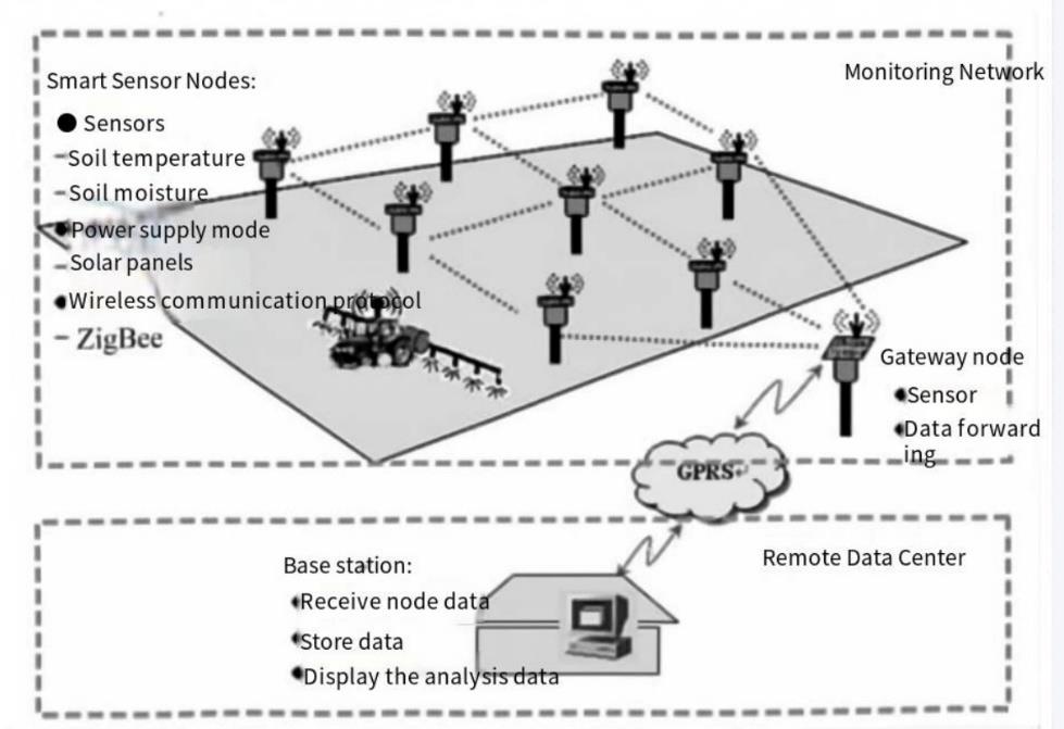
Figure 1. Each smart sensor transmits data to the central gateway node through the wireless communication protocol (ZigBee), and then the gateway node transmits data to the remote data center through GPRS for further storage and analysis of data.
The wireless sensor monitoring network is composed of a number of intelligent sensor nodes distributed in the field, in which the intelligent sensor node is a miniature embedded system with certain information processing and communication capabilities. Gateway node: The gateway node requires stronger processing power and running speed than the sensor node, so the ARM microprocessor with rich on-chip resources can be selected as the core, and the hardware communication interface can be extended according to the specific functional requirements. The functional design can be customized with the embedded Linux operating system. Real-time collection of soil temperature, soil moisture, soil pH and atmospheric pressure data. The Mesh network is built based on ZigBee wireless communication protocol. All node data are finally routed to the gateway node, which forwards all data to the remote data center through GPRS wireless communication transmission mode. The remote data center is a computer with a fixed public IP address. The main functions of the base station data management software running on it are: to realize the reception, storage, analysis and decision of data to complete the corresponding control process. Its functional modules can be divided into: data receiving module, database storage module, monitoring quantity time change analysis module, monitoring quantity spatial variation analysis module, can be provided with other agricultural machinery operation control module (such as control irrigation system unattended operation). All nodes in the detection network can be powered by solar panels, and the remote data center is responsible for receiving, storing and analyzing the data, and finally matching the obtained comprehensive data with the national information database to screen out the best soil for crops.
3. Conclusion
In this paper, by studying the crops most suitable for soil, the soil detection method based on WSN, Starting from the four perspectives of soil moisture content,PH value, pressure and temperature, WSN nodes cover a large area of land to obtain various data, and then transmit data from each node to the central node. Finally, the most suitable crops are obtained by comparing the data obtained through the central node with the resource network. Among them, data fusion technology [12] is used to process multiple pieces of data or information. It can reduce the amount of network data, reduce network congestion, and prolong the life of the network. The data source in this paper has certain limitations, and the precision matching of crops has certain errors. In the future, the continuous advancement of agricultural informatization will definitely make WSN technology truly become an essential tool for farmers' planting and breeding.
References
[1]. J. von Braun, “The food crisis isn't over,” Nature, vol. 456, Dec. 2008.
[2]. Ciba Foundation Symposium, Precision Agriculture: Spatial and Temporal Variability of Environmental Quality, John Wiley & Sons, Chichester (England), 1997.
[3]. P. Corke, T. Wark, R. Jurdak, Environmental wireless sensor networks, Proceedings of IEEE 98 (11) (2010) 1903–1917.
[4]. K. Langendoen, A. Baggio, O. Visser, Experience from a pilot sensor network deployment in precision agriculture, in: Parallel and Distributed Processing, IPDPS, 2006 20th IEEE International Symposium, 2006.
[5]. D.H. Park, B.J. Kang, K.R. Cho, A study on greenhouse automatic control system based on wireless sensor network, Wireless Personal Communications 56 (2011) 117–130.
[6]. Narasimhan, V. Lakshmi, Alex A. Arvind and Ken Bever, 2007. Greenhouse Asset Management Using Wireless Sensor-Actor Networks, Proceeding of Int. Conf. On Mobile Ubiquitous Computing, Systems, Services and Technologies, pp: 9-14.
[7]. N. Sakthipriya Middle-East Journal of Scientific Research 20 (9): 1127-1132, 2014
[8]. Krishnan S. R. S., & Arunkumar. T. (2023). Adaptive recommendation routing for node efficiency for wireless sensor network. International journal on emerging technologies, 10(4), 62-65
[9]. Bogena, H.R., Huisman, J.A., Oberdörster, C., Vereecken, H., 2007. Evaluation of a low-cost soil water content sensor for wireless network applications. Journal of Hydrology 344, 32–42
[10]. Vijayakumar S,Rosario JN. Preliminary design for crop monitoring involving water and fertilizer conservation using wireless sensor networks[C]/ / Communication Software and Networks ( ICCSN) [A]. Xi'an: 2011 IEEE 3rd International Conference.
[11]. Yu Xiaoqing, Wu Pute, Han Wenting, et al. Remote Monitoring System for Farmland irrigation based on Wireless Sensor Network [J]. Journal of Drainage and Irrigation Machinery Engineering, 2013,31 (6) : 67-80.
[12]. Kang Jian, Zuo Charter, Tang Liwei, et al. Wireless sensor network data fusion technology [J]. Computer Science, 2010,37 (4) : 31-35.
Cite this article
Wang,X. (2024). Resource allocation design method based on WSN multi-dimension soil inspection. Applied and Computational Engineering,82,77-81.
Data availability
The datasets used and/or analyzed during the current study will be available from the authors upon reasonable request.
Disclaimer/Publisher's Note
The statements, opinions and data contained in all publications are solely those of the individual author(s) and contributor(s) and not of EWA Publishing and/or the editor(s). EWA Publishing and/or the editor(s) disclaim responsibility for any injury to people or property resulting from any ideas, methods, instructions or products referred to in the content.
About volume
Volume title: Proceedings of the 2nd International Conference on Machine Learning and Automation
© 2024 by the author(s). Licensee EWA Publishing, Oxford, UK. This article is an open access article distributed under the terms and
conditions of the Creative Commons Attribution (CC BY) license. Authors who
publish this series agree to the following terms:
1. Authors retain copyright and grant the series right of first publication with the work simultaneously licensed under a Creative Commons
Attribution License that allows others to share the work with an acknowledgment of the work's authorship and initial publication in this
series.
2. Authors are able to enter into separate, additional contractual arrangements for the non-exclusive distribution of the series's published
version of the work (e.g., post it to an institutional repository or publish it in a book), with an acknowledgment of its initial
publication in this series.
3. Authors are permitted and encouraged to post their work online (e.g., in institutional repositories or on their website) prior to and
during the submission process, as it can lead to productive exchanges, as well as earlier and greater citation of published work (See
Open access policy for details).
References
[1]. J. von Braun, “The food crisis isn't over,” Nature, vol. 456, Dec. 2008.
[2]. Ciba Foundation Symposium, Precision Agriculture: Spatial and Temporal Variability of Environmental Quality, John Wiley & Sons, Chichester (England), 1997.
[3]. P. Corke, T. Wark, R. Jurdak, Environmental wireless sensor networks, Proceedings of IEEE 98 (11) (2010) 1903–1917.
[4]. K. Langendoen, A. Baggio, O. Visser, Experience from a pilot sensor network deployment in precision agriculture, in: Parallel and Distributed Processing, IPDPS, 2006 20th IEEE International Symposium, 2006.
[5]. D.H. Park, B.J. Kang, K.R. Cho, A study on greenhouse automatic control system based on wireless sensor network, Wireless Personal Communications 56 (2011) 117–130.
[6]. Narasimhan, V. Lakshmi, Alex A. Arvind and Ken Bever, 2007. Greenhouse Asset Management Using Wireless Sensor-Actor Networks, Proceeding of Int. Conf. On Mobile Ubiquitous Computing, Systems, Services and Technologies, pp: 9-14.
[7]. N. Sakthipriya Middle-East Journal of Scientific Research 20 (9): 1127-1132, 2014
[8]. Krishnan S. R. S., & Arunkumar. T. (2023). Adaptive recommendation routing for node efficiency for wireless sensor network. International journal on emerging technologies, 10(4), 62-65
[9]. Bogena, H.R., Huisman, J.A., Oberdörster, C., Vereecken, H., 2007. Evaluation of a low-cost soil water content sensor for wireless network applications. Journal of Hydrology 344, 32–42
[10]. Vijayakumar S,Rosario JN. Preliminary design for crop monitoring involving water and fertilizer conservation using wireless sensor networks[C]/ / Communication Software and Networks ( ICCSN) [A]. Xi'an: 2011 IEEE 3rd International Conference.
[11]. Yu Xiaoqing, Wu Pute, Han Wenting, et al. Remote Monitoring System for Farmland irrigation based on Wireless Sensor Network [J]. Journal of Drainage and Irrigation Machinery Engineering, 2013,31 (6) : 67-80.
[12]. Kang Jian, Zuo Charter, Tang Liwei, et al. Wireless sensor network data fusion technology [J]. Computer Science, 2010,37 (4) : 31-35.