


1. Introduction
Climate change is one of the most critical challenges confronting our world today, with far-reaching effects on ecosystems, weather patterns, and human health. As global temperatures increase, extreme weather events such as hurricanes, droughts, and heat waves are becoming more frequent and intense[1, 2, 3], which endanger natural ecosystems and present serious threats to agriculture, water resources, and public health. Earthquakes, on the other hand, inflict immediate damage to infrastructure and businesses, which results in lasting financial burdens. Environmentally, earthquakes can reshape landscapes and trigger natural disasters such as tsunamis. The interconnection between these impacts highlights the complexity of addressing the challenges posed by earthquakes and the climate [4, 5]. The interaction between climate change and earthquakes has been a challenge in the scientific community, as the two phenomena occur through different natural processes yet may have complex interconnections. While earthquakes are primarily driven by tectonic activity—such as the movement of the Earth's plates—there is increasing interest in understanding how climate change might influence seismic activity indirectly. For instance, rising global temperatures have led to the accelerated melting of glaciers and ice caps, which reduces pressure on the Earth's crust. This process, known as "glacial isostatic adjustment," can lead to shifts in tectonic plates and potentially trigger earthquakes in certain regions [6, 7]. On the other hand, changes in weather patterns amid global warming, such as increased precipitation or prolonged droughts, may affect fault lines. Heavy rainfall or flooding can cause water to seep into faults, altering the pressure and stability in the Earth's crust [8], while droughts can lead to the shrinking of underground reservoirs, also shifting pressure balances[9, 10]. Understanding these interactions is crucial for enhancing predictive models and developing adaptive strategies for communities living in earthquake-prone areas, especially as climate change continues to amplify extreme environmental conditions across the globe [11]. However, more research is needed to conclusively establish the scope and significance of these links, making this an evolving area of interdisciplinary scientific inquiry.
The main purpose of this research is to shed light on the compound impacts of severe earthquake-climate events and offer potential insights for operational forecasting, highlighting the intricate ways these phenomena interconnect to drive significant environmental disasters. The remainder of this manuscript is given as follows: in Section 2 we will address how earthquake impacts climate with and without volcanic eruptions. The influence of climate on earthquakes will be discussed in Section 3, followed by the conclusion and implications in Section 4.
2. Earthquakes’ impacts on climate
2.1. Earthquakes(without volcanic eruptions)impacts
Temperature rises after an earthquake: Before an earthquake occurs, stress within the Earth's crust continually accumulates. This stress accumulation can lead to changes in the microstructure of rocks, potentially creating microcracks [12]. The formation and expansion of these microcracks release heat, causing a local temperature increase. Additionally, fluids such as groundwater and natural gas may move before an earthquake due to crustal deformation. The movement of these fluids can alter the thermal conductivity properties of the surface, thereby affecting surface temperature. In some cases, the upward movement of hot fluids may directly cause a rise in surface temperature. Lastly, before an earthquake, minor slippage along fault planes may occur, and the frictional heat generated by this slippage can lead to a local increase in temperature [13,14,15].
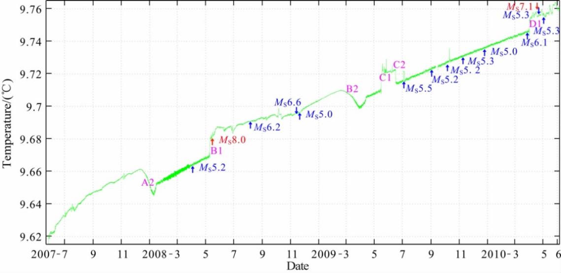
Figure 1: Temperature data curve recorded by Delingha Seismic Station (He et al., 2012). The Delingha Seismic Station is located in Delingha City, Haixi Prefecture, Qinghai Province (97.38°E, 37.37°N) in China.
A typical example of this argument is given by He et al. [16] show that, on the normal dynamic background of a long-term upward trend in Delingha well water temperature, there were three approximate "L"-shaped rapid rise processes (segments B1, C1, D1) and three regression processes (segments A2, B2, C2) indicating non-steady-state changes. For the three "L"-shaped rapid rise processes, the analysis revealed that, except for C1, which may have been due to external observational environmental factors, the other two had a clear correlation with seismic activity within a certain range during the same period. Systematic analysis results show that before the Wenchuan MS8.0 earthquake on May 12, 2008, and the Yushu MS7.1 earthquake on April 14, 2010, there were abnormal "L"-shaped rapid rises a few days prior. Thus, in two out of the three "L"-shaped rapid rises, earthquakes occurred. Among the 14 earthquakes that occurred during the observation period, this type of anomaly appeared before both earthquakes with MS≥7.0. Therefore, there is reason to believe that the "L"-shaped rapid rise in Delingha well water temperature may be an earthquake precursor anomaly related to major seismic activity in the region. This example supports the argument mentioned above, as the rapid temperature increase may be linked to seismic activity. However, in the long term, further in-depth research is required to fully understand this relationship and confirm any direct causal connections.
2.2. Earthquakes’ (with volcanic eruptions) impacts on the climate
Since earthquakes are sometimes accompanied by volcanic eruptions [17], considering the impact of volcanic eruptions on the climate is needed. When volcanic eruptions happen, significant amounts of sulfur dioxide (SO2) and hydrogen sulfide (H2S) will be injected into the stratosphere, where they react with hydroxyl radicals (OH) and water (H2O) to form H2SO4, forming sulfuric acid aerosols. This phenomenon is called Volcanic winter. These aerosols increase the Earth's albedo, thereby reducing global temperatures. This cooling effect is achieved as the sulfuric acid aerosols reflect solar radiation, cooling the Earth's surface, and this effect can last for several years. Moreover, feedback mechanisms among the atmosphere, ice, and oceans can sustain the cooling trend even after the volcanic aerosols dissipate. The cooling effect leads to a lowering of the snowline and rapid expansion of sea ice, ice caps, and continental glaciers, which further lowers ocean temperatures and increases surface albedo. These processes create a strong positive feedback loop, allowing the cooling trend to persist over centuries or even longer. [18,19,20,21]
This effect can be further explained by the example that happened in Mount Pinatubo. In April 1991, a series of small earthquakes began to occur near the volcano, gradually intensifying and becoming a precursor to the eruption. Before the major eruption in June, seismic activity increased further, ultimately leading to the catastrophic volcanic eruption. In June 1991, the Mount Pinatubo volcano in the Philippines experienced a massive eruption, releasing a large amount of ash and gases, significantly affecting the global climate[22]. PARKER et al. [22] analyzed temperature changes before and after the eruption, using various data sources, including air temperature records from ground meteorological stations and nighttime marine air temperature (NMAT) data, to calculate the average temperature after the volcanic eruption. In the 0-10 months following the eruption, the temperature decreased linearly, reaching a maximum drop of around -0.2 degrees Celsius, and it took until 40 months later for the temperature to return to its initial normal level, thereby providing clearer identification of the cooling effects caused by the volcanic event.
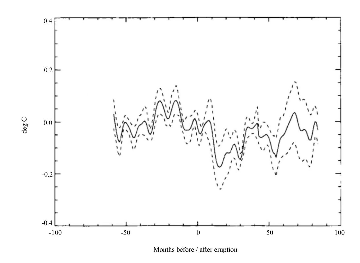
Figure 2: Temperature change after the Mount Pinatubo volcano eruption (PARKER et al., 1996); The dashed line refers to the predicted temperature; the full line refers to the real temperature.
In summary, earthquakes can impact the climate both with and without volcanic eruptions, though the mechanisms of these impacts differ significantly. Without volcanic eruptions, earthquakes primarily lead to localised increases in temperature due to stress accumulation, microcrack formation, fluid movement, and frictional heat along fault lines. The Delingha Seismic Station's observations, for example, show that local temperature rises are often correlated with seismic activity, though they are short-term. When earthquakes are accompanied by volcanic eruptions, the climate impact becomes more significant. The release of sulfur dioxide and other gases during eruptions results in the formation of sulfuric acid aerosols in the stratosphere, which can cause a "volcanic winter." This phenomenon cools the Earth's surface by reflecting solar radiation, as shown in the case of the Mount Pinatubo eruption.
2.3. Earthquakes’ Impacts on the climate in the polar region
Because there are large glaciers in polar regions and the environment is different from that in mid- to low-latitudes, earthquakes may have different impacts on the climate. Therefore, studying earthquakes in Antarctica is crucial. Antarctica's ice is composed of different types of glaciers: grounded glaciers that rest on bedrock, ice shelves that float on the ocean, and sea ice. An ice shelf is a floating ice mass attached to the front of a grounded glacier, which slides over bedrock into the ocean. Grounded glaciers rest on various types of rocks, including sedimentary, crystalline, or metamorphic, and their bases often lie below sea level. Near the coast, these glaciers predominantly rest on sedimentary rocks. Ice shelves, when stable, can act as a barrier, preventing the grounded glaciers behind them from sliding into the sea.[23,24]
Lobkovsky et al. [25] claim that the movement of glaciers can be understood through a simplified model that reflects their thermo-mechanical evolution over time (shown in the figure). Initially, a grounded glacier moves slowly along the bedrock, with its base fully adhering to the underlying sedimentary rock surface. The speed can vary significantly, ranging from a few meters to several hundred meters per year. For instance, during the "cold" phase of a glacier's slow movement, where it remains fully adhered to the bedrock, the glacier might only shift a few kilometres over a millennium.
The second phase, known as the "warm" stage, marks a significant change as melting zones develop at the glacier's base due to increased heat flow from beneath, a common phenomenon in large areas of West Antarctica. As the ice melts, the glacier begins to slide more freely along the bedrock. However, this stage does not lead to a rapid, catastrophic slide because the melting is uneven, caused by the irregular geometry of the base, pressure variations, and other physical and mechanical factors. "Dry" areas remain between the melting zones, maintaining adhesion between the glacier and the bedrock. This second stage can last for several decades until the third stage.
The third stage of the glacier locomotion occurs when these adhesion zones vanish, leading to the glacier detaching from the bedrock. This detachment is completed by the fracturing of the glacier's rear sections, resulting in faults and cracks. In this model, the third stage of block movement and the glacier disruption is triggered by tectonic deformation waves reaching Antarctica from large subduction earthquakes, which destroy the remaining adhesion zones. This seismogenic trigger mechanism sets off glacier collapse.
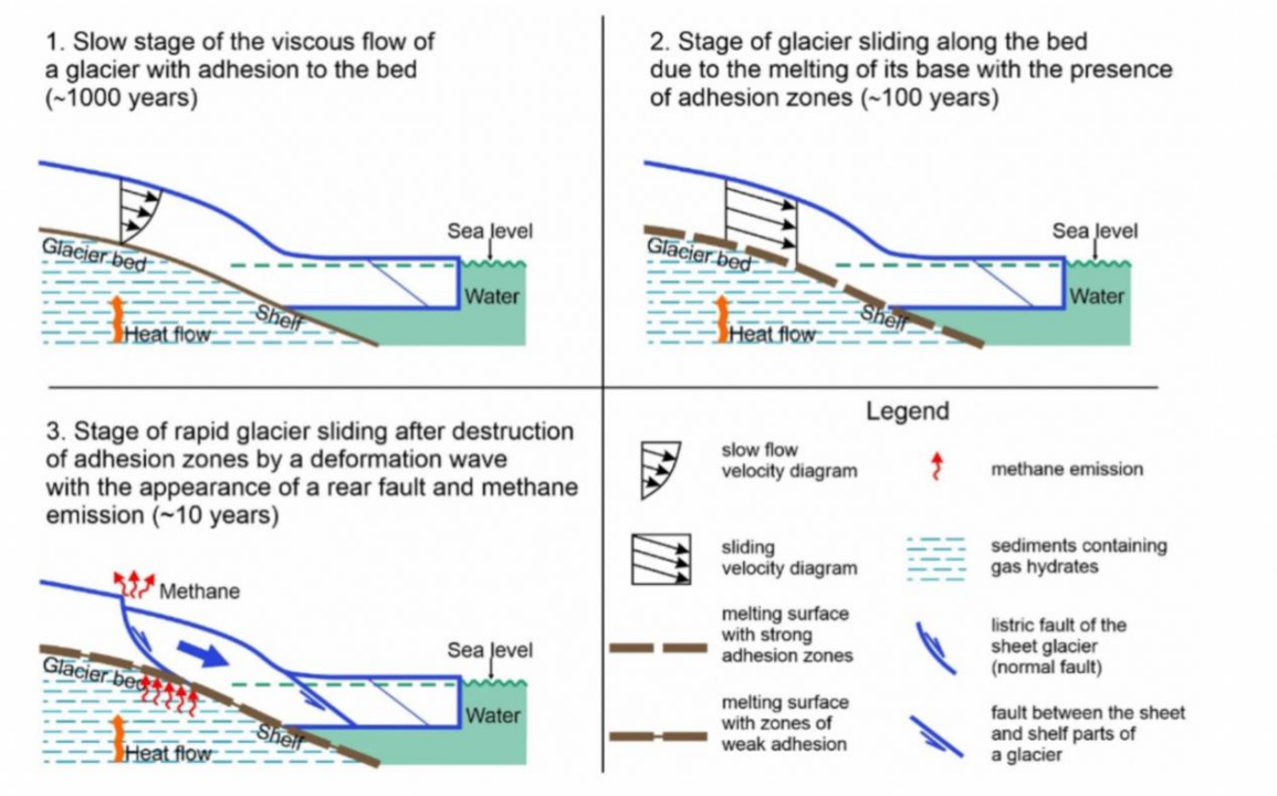
Figure 3: Movement of glaciers in the polar region [25]
The glacier movement and destruction in the third stage are closely linked to the rapid warming of Antarctica's climate. To understand this, we must consider the structure of the Antarctic crust, characterised by extensive sedimentary basins formed during its geological evolution. For example, the crust of West Antarctica underwent rifting, leading to the creation of sedimentary basins beneath the surrounding seas. Seismic and drilling data indicate that the upper layers of these sediments are composed of Cenozoic molasses and permafrost rocks, with shallow seas and ice shelves above them. Beneath the ice sheets of Antarctica, sedimentary rocks may contain significant amounts of gas hydrates, a form of methane gas. When the ice cover is destroyed, the release of methane from these gas hydrates can lead to atmospheric emissions and climate warming. Specifically, as glaciers slide rapidly, the hydrostatic pressure in the underlying sediments, which may contain gas hydrates, decreases in the rear fault and crack zones. This reduction in pressure destabilises the gas hydrates, releasing trapped methane from low-permeability frozen rocks and partially dissociated gas hydrate particles. The released free methane can then quickly filter through the fractured glacier and escape into the atmosphere. Since methane is a greenhouse gas with a warming effect nearly 20 times that of carbon dioxide, this process is considered a key mechanism for the sharp increase in methane emissions and climate warming in West Antarctica.
At the same time, the tectonic deformation waves that destroy the glaciers can affect the stability of the sedimentary rocks, further triggering the release of gas hydrates. When these deformation waves reach the sedimentary rock layers, they generate additional stress within the rocks, exacerbating the dissociation of gas hydrates. As gas is released and hydrostatic pressure decreases, the microstructure of the sedimentary rocks can be compromised, forming microcracks and microchannels that allow gas to permeate into the glacier. This phenomenon not only accelerates the release of methane but may also lead to broader environmental impacts, further driving climate warming in Antarctica and its surrounding areas. Additionally, climate warming can lead to more snowfall and glacier melting, resulting in decreased albedo in Antarctica, which in turn absorbs more solar radiation. This creates a positive feedback loop that causes temperatures to continue rising.
3. Climate effects on the earthquakes
3.1. Coulomb’s Theory
Before discussing how climate change affects earthquakes, we need to know the Coulomb Rupture Theory [8]:
τcrit = μ(σn – P) + So,
\( {τ_{crit}}=μ({σ_{n}}-P)+{S_{0}} \)
Where \( {τ_{crit}} \) is the critical shear stress needed for failure, \( μ \) is the coefficient of friction, \( {σ_{n}} \) is the normal stress across the fault, \( P \) is the pore-fluid pressure within the fault, and \( {S_{0}} \) is a constant related to the cohesive strength of the fault. Shear slip may thus be brought about by an increase in shear stress or pore-fluid pressure or by a reduction in normal stress or fault cohesion. Based on this theory, the trigger of earthquakes by the precipitation and the temperature can be explained.
3.2. How precipitation affects earthquakes
Precipitation plays a significant role in earthquakes. Wilson et al. [8] used this theory to report that rainfall can cause surface water to infiltrate the ground, increasing the pore water pressure in soil and rocks. This pressure change can reduce the effective stress on rocks, making faults in the Earth's crust more prone to slipping and potentially triggering earthquakes. Changes in pore fluid pressure caused by rainfall as low as 0.5 kPa can trigger earthquakes, a value much lower than the traditional threshold for earthquake triggering. The same principle applies to snowfall; surface water from melting snow can also more easily induce earthquakes. Here’s an example that happened in Peru that can further prove this idea proposed by Liu and Yao [26]. On May 26, 2019, an Mw 8.0 intermediate-depth earthquake occurred in Peru, with the epicentre located at the leading edge of the Nazca-South American subduction zone, at a depth of approximately 122.57 kilometres. Since the earthquake occurred in northern Peru, where annual precipitation is quite abundant, and considering that the region is in the Southern Hemisphere with the rainy season typically occurring from November to April, the influence of precipitation on this major earthquake cannot be overlooked according to the theory of precipitation's lagging effects.
3.3. How temperature affects earthquakes
Wilson et al. [8] mentioned that temperature changes can cause rocks and crustal materials to expand or contract thermally, leading to stress variations. This thermal stress may affect faults that are already in a critical state, making them more prone to slipping and potentially triggering earthquakes. Additionally, as temperatures rise, the strength of rocks may decrease, especially under high-temperature conditions. The plastic behaviour of rocks may make them more susceptible to deformation and fracturing under stress, and in many cases, some rocks may begin to melt. Melts, if sufficiently hot, the strength decreases with continued shear and heating, which increases melt volume and raises its temperature, reducing its viscosity and may lubricate faults, reducing dynamic friction. Finally, temperature changes, such as warming, can lead to glacier melting, resulting in rising groundwater levels. This can alter the stress on fault lines, reduce the friction coefficient, and induce earthquakes.
3.4. Earthquakes Occurrence and Interglacial Period
By analysing the mechanism by which temperature affects earthquakes, it is likely to speculate that major earthquakes are more likely to occur during interglacial periods.
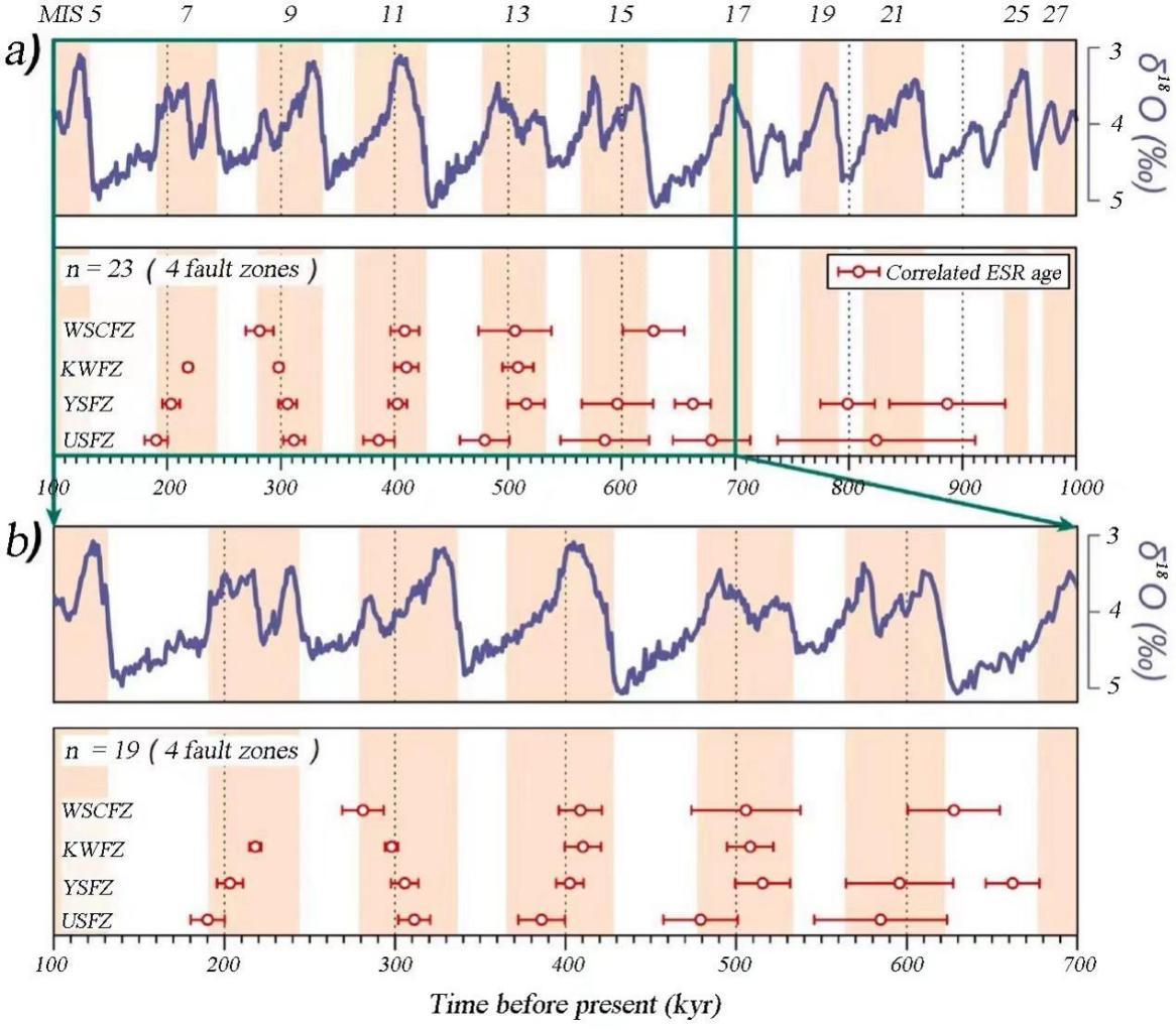
Figure 4: Comparison of the temporal pattern of Quaternary fault activity across the Korean Peninsula with the MIS. The time frames are (a) between 1000 and 100 ka, and (b) between 700 and 100k [27]
Kim and Lee [27] used electron spin resonance (ESR) age data from four major fault zones in the Korean Peninsula (Keumwang, Wangsukcheon, Yangsan, and Ulsan) to determine the timing of fault activity and seismic events. This data was compared with marine isotope stages (MIS) records to explore the impact of climate change on seismic activity. MIS describes the timeline of Earth's climate changes, primarily based on variations in oxygen isotope ratios in marine sediments. Changes in these isotope ratios reflect global climate cooling and warming cycles, typically corresponding to glacial and interglacial periods. The author measured the isotope (δ18O), with higher levels indicating warmer temperatures. Therefore, areas where the blue line rises or where the values are higher are shaded orange, representing interglacial periods. From Figure 4, it can be observed that, in both the a and b graphs, earthquakes predominantly occurred during interglacial periods across different time scales. This can directly show the strong relationship between the time of the interglacial period and the occurrence frequency of the earthquakes. During interglacial periods, global temperatures rise, leading to the melting of ice sheets and glaciers, which results in a significant influx of water into the oceans, causing sea levels to rise. As sea levels rise, seawater infiltrates the underground aquifers in coastal areas, leading to an increase in pore water levels and, consequently, an increase in pore pressure. This increase in pore pressure reduces the effective stress in soils or rocks, as described by Coulomb's Theory mentioned earlier.
4. Conclusion
This paper examines the intricate interactions between seismic activity and climate change, highlighting how each can influence the other. It discusses how earthquakes, even without volcanic eruptions, can lead to localised temperature rises through stress accumulation, microcrack formation, fluid movement, and frictional heat, as demonstrated by observations at the Delingha Seismic Station. When volcanic eruptions accompany earthquakes, sulfuric acid aerosols are released, reflecting solar radiation and causing long-term global cooling, as seen in the Mount Pinatubo eruption. In polar regions, earthquakes can trigger glacier movement, fracturing, and methane release, contributing to significant climate warming. The paper also explains how climate factors based on Columob’s theory, such as precipitation and temperature, can influence earthquake occurrence through mechanisms like increased pore pressure on fault lines. The research presents the innovative idea that major earthquakes may be more frequent during interglacial periods due to climatic conditions, adding a new dimension to understanding earthquake-climate interactions.
The implications of this research are significant for both the scientific community and society, as it deepens our understanding of the intricate connections between seismic activity and climate change, providing valuable insights for improving earthquake and climate prediction models, especially in the context of a warming world.
References
[1]. Mann, M. E., & Emanuel, K. A. (2006). Atlantic hurricane trends linked to climate change. Eos, Transactions American Geophysical Union, 87(24), 233-241.
[2]. Loukas, A., Vasiliades, L., & Tzabiras, J. (2008). Climate change effects on drought severity. Advances in Geosciences, 17, 23-29
[3]. Mukherjee, S., Mishra, A., & Trenberth, K. E. (2018). Climate change and drought: a perspective on drought indices. Current climate change reports, 4, 145-163.
[4]. Li, C., Wang, M., Liu, K., & Coulthard, T. J. (2020). Landscape evolution of the Wenchuan earthquake-stricken area in response to future climate change. Journal of Hydrology, 590, 125244.
[5]. Kanamori, H. (1972). Mechanism of tsunami earthquakes. Physics of the Earth and planetary interiors, 6(5), 346-359.
[6]. Abram, N. J., Mulvaney, R., Wolff, E. W., Triest, J., Kipfstuhl, S., Trusel, L. D., ... & Arrowsmith, C. (2013). Acceleration of snow melts in an Antarctic Peninsula ice core during the twentieth century. Nature Geoscience, 6(5), 404-411.
[7]. Steffen, R., Wu, P., Steffen, H., & Eaton, D. W. (2014). On the implementation of faults in finite-element glacial isostatic adjustment models. Computers & Geosciences, 62, 150-159.
[8]. Wilson, M. P., Foulger, G. R., Saville, C., Graham, S. P., & Julian, B. R. (2022). Earthquake weather and climate change: Should we stress about the forecast?
[9]. Famiglietti, J. S. (2014). The global groundwater crisis. Nature Climate Change, 4(11), 945–948. https://doi.org/10.1038/nclimate2425
[10]. Konikow, L. F. (2014b). Groundwater Depletion in the United States (1900? 2008). CreateSpace.
[11]. UNDP. (2024, January 30). What is climate change adaptation, and why is it crucial? UNDP Climate Promise. https://climatepromise.undp.org/news-and-stories/what-climate-change-adaptation-and-why-it-crucial
[12]. Inkenbrandt, P. (2017, October 1). 9 Crustal Deformation and Earthquakes – An Introduction to Geology. https://opengeology.org/textbook/9-crustal-deformation-and-earthquakes/
[13]. Aubry, J., Passelègue, F. X., Deldicque, D., Girault, F., Marty, S., Lahfid, A., ... & Schubnel, A. (2018). Frictional heating processes and energy budget during laboratory earthquakes. Geophysical Research Letters, 45(22), 12-274.
[14]. Mase, C. W., & Smith, L. (1987). Effects of frictional heating on the thermal, hydrologic, and mechanical response of a fault. Journal of Geophysical Research: Solid Earth, 92(B7), 6249-6272.
[15]. Patterson, J. W., Driesner, T., Matthai, S., & Tomlinson, R. (2018). Heat and fluid transport induced by convective fluid circulation within a fracture or fault. Journal of Geophysical Research: Solid Earth, 123(4), 2658-2673.
[16]. He, A. H., Zhao, G., Liu, C. L., & Fan, L. L. (2012). The anomaly characteristics before the Wenchuan earthquake and the Yushu earthquake in Qinghai Yushu and Delingha geothermal observation wells. Chinese Journal of Geophysics, 55(4), 1261-1268.
[17]. Seropian, G., Kennedy, B. M., Walter, T. R., Ichihara, M., & Jolly, A. D. (2021). A review framework of how earthquakes trigger volcanic eruptions. Nature Communications, 12(1), 1004.
[18]. Stothers, R. B., Rampino, M. R., Self, S., & Wolff, J. A. (1989). Volcanic winter? Climatic effects of the largest volcanic eruptions. In Volcanic Hazards: Assessment and Monitoring (pp. 3-9). Springer Berlin Heidelberg.
[19]. Self, S., & Rampino, M. R. (1988). The relationship between volcanic eruptions and climate change: Still a conundrum?. Eos, Transactions American Geophysical Union, 69(6), 74-86.
[20]. Robock, A. (2000). Volcanic eruptions and climate. Reviews of geophysics, 38(2), 191-219.
[21]. Wikipedia Contributors. (2019c, November 2). Volcanic winter. Wikipedia; Wikimedia Foundation. https://en.wikipedia.org/wiki/Volcanic_winter
[22]. PARKER, D. E., Wilson, H., Jones, P. D., Christy, J. R., & Folland, C. K. (1996). The impact of Mount Pinatubo on worldwide temperatures. International Journal of Climatology: A Journal of the Royal Meteorological Society, 16(5), 487-497.
[23]. Fretwell, P., Pritchard, H. D., Vaughan, D. G., Bamber, J. L., Barrand, N. E., Bell, R., ... & Zirizzotti, A. (2013). Bedmap2: improved ice bed, surface and thickness datasets for Antarctica. The cryosphere, 7(1), 375-393.
[24]. Christie, F. D., Benham, T. J., Batchelor, C. L., Rack, W., Montelli, A., & Dowdeswell, J. A. (2022). Antarctic ice-shelf advance driven by anomalous atmospheric and sea-ice circulation. Nature Geoscience, 15(5), 356-362.
[25]. Lobkovsky, L. I., Baranov, A. A., Ramazanov, M. M., Vladimirova, I. S., Gabsatarov, Y. V., Semiletov, I. P., & Alekseev, D. A. (2022). Trigger mechanisms of gas hydrate decomposition, methane emissions, and glacier breakups in polar regions as a result of tectonic wave deformation. Geosciences, 12(10), 372.
[26]. Liu, W., & Yao, H. (2020). Rupture process of the 26 May 2019 Mw 8.0 northern Peru intermediate‐depth earthquake and insights into its mechanism. Geophysical Research Letters, 47(4), e2020GL087167.
[27]. Kim, M. J., & Lee, H. K. (2023). Long-term patterns of earthquakes influenced by climate change: insights from earthquake recurrence and stress field changes across the Korean Peninsula during interglacial periods. Quaternary Science Reviews, 321, 108369.
Cite this article
Wang,R. (2025). The Interactions Between Earthquakes and Climate. Applied and Computational Engineering,124,156-164.
Data availability
The datasets used and/or analyzed during the current study will be available from the authors upon reasonable request.
Disclaimer/Publisher's Note
The statements, opinions and data contained in all publications are solely those of the individual author(s) and contributor(s) and not of EWA Publishing and/or the editor(s). EWA Publishing and/or the editor(s) disclaim responsibility for any injury to people or property resulting from any ideas, methods, instructions or products referred to in the content.
About volume
Volume title: Proceedings of the 5th International Conference on Materials Chemistry and Environmental Engineering
© 2024 by the author(s). Licensee EWA Publishing, Oxford, UK. This article is an open access article distributed under the terms and
conditions of the Creative Commons Attribution (CC BY) license. Authors who
publish this series agree to the following terms:
1. Authors retain copyright and grant the series right of first publication with the work simultaneously licensed under a Creative Commons
Attribution License that allows others to share the work with an acknowledgment of the work's authorship and initial publication in this
series.
2. Authors are able to enter into separate, additional contractual arrangements for the non-exclusive distribution of the series's published
version of the work (e.g., post it to an institutional repository or publish it in a book), with an acknowledgment of its initial
publication in this series.
3. Authors are permitted and encouraged to post their work online (e.g., in institutional repositories or on their website) prior to and
during the submission process, as it can lead to productive exchanges, as well as earlier and greater citation of published work (See
Open access policy for details).
References
[1]. Mann, M. E., & Emanuel, K. A. (2006). Atlantic hurricane trends linked to climate change. Eos, Transactions American Geophysical Union, 87(24), 233-241.
[2]. Loukas, A., Vasiliades, L., & Tzabiras, J. (2008). Climate change effects on drought severity. Advances in Geosciences, 17, 23-29
[3]. Mukherjee, S., Mishra, A., & Trenberth, K. E. (2018). Climate change and drought: a perspective on drought indices. Current climate change reports, 4, 145-163.
[4]. Li, C., Wang, M., Liu, K., & Coulthard, T. J. (2020). Landscape evolution of the Wenchuan earthquake-stricken area in response to future climate change. Journal of Hydrology, 590, 125244.
[5]. Kanamori, H. (1972). Mechanism of tsunami earthquakes. Physics of the Earth and planetary interiors, 6(5), 346-359.
[6]. Abram, N. J., Mulvaney, R., Wolff, E. W., Triest, J., Kipfstuhl, S., Trusel, L. D., ... & Arrowsmith, C. (2013). Acceleration of snow melts in an Antarctic Peninsula ice core during the twentieth century. Nature Geoscience, 6(5), 404-411.
[7]. Steffen, R., Wu, P., Steffen, H., & Eaton, D. W. (2014). On the implementation of faults in finite-element glacial isostatic adjustment models. Computers & Geosciences, 62, 150-159.
[8]. Wilson, M. P., Foulger, G. R., Saville, C., Graham, S. P., & Julian, B. R. (2022). Earthquake weather and climate change: Should we stress about the forecast?
[9]. Famiglietti, J. S. (2014). The global groundwater crisis. Nature Climate Change, 4(11), 945–948. https://doi.org/10.1038/nclimate2425
[10]. Konikow, L. F. (2014b). Groundwater Depletion in the United States (1900? 2008). CreateSpace.
[11]. UNDP. (2024, January 30). What is climate change adaptation, and why is it crucial? UNDP Climate Promise. https://climatepromise.undp.org/news-and-stories/what-climate-change-adaptation-and-why-it-crucial
[12]. Inkenbrandt, P. (2017, October 1). 9 Crustal Deformation and Earthquakes – An Introduction to Geology. https://opengeology.org/textbook/9-crustal-deformation-and-earthquakes/
[13]. Aubry, J., Passelègue, F. X., Deldicque, D., Girault, F., Marty, S., Lahfid, A., ... & Schubnel, A. (2018). Frictional heating processes and energy budget during laboratory earthquakes. Geophysical Research Letters, 45(22), 12-274.
[14]. Mase, C. W., & Smith, L. (1987). Effects of frictional heating on the thermal, hydrologic, and mechanical response of a fault. Journal of Geophysical Research: Solid Earth, 92(B7), 6249-6272.
[15]. Patterson, J. W., Driesner, T., Matthai, S., & Tomlinson, R. (2018). Heat and fluid transport induced by convective fluid circulation within a fracture or fault. Journal of Geophysical Research: Solid Earth, 123(4), 2658-2673.
[16]. He, A. H., Zhao, G., Liu, C. L., & Fan, L. L. (2012). The anomaly characteristics before the Wenchuan earthquake and the Yushu earthquake in Qinghai Yushu and Delingha geothermal observation wells. Chinese Journal of Geophysics, 55(4), 1261-1268.
[17]. Seropian, G., Kennedy, B. M., Walter, T. R., Ichihara, M., & Jolly, A. D. (2021). A review framework of how earthquakes trigger volcanic eruptions. Nature Communications, 12(1), 1004.
[18]. Stothers, R. B., Rampino, M. R., Self, S., & Wolff, J. A. (1989). Volcanic winter? Climatic effects of the largest volcanic eruptions. In Volcanic Hazards: Assessment and Monitoring (pp. 3-9). Springer Berlin Heidelberg.
[19]. Self, S., & Rampino, M. R. (1988). The relationship between volcanic eruptions and climate change: Still a conundrum?. Eos, Transactions American Geophysical Union, 69(6), 74-86.
[20]. Robock, A. (2000). Volcanic eruptions and climate. Reviews of geophysics, 38(2), 191-219.
[21]. Wikipedia Contributors. (2019c, November 2). Volcanic winter. Wikipedia; Wikimedia Foundation. https://en.wikipedia.org/wiki/Volcanic_winter
[22]. PARKER, D. E., Wilson, H., Jones, P. D., Christy, J. R., & Folland, C. K. (1996). The impact of Mount Pinatubo on worldwide temperatures. International Journal of Climatology: A Journal of the Royal Meteorological Society, 16(5), 487-497.
[23]. Fretwell, P., Pritchard, H. D., Vaughan, D. G., Bamber, J. L., Barrand, N. E., Bell, R., ... & Zirizzotti, A. (2013). Bedmap2: improved ice bed, surface and thickness datasets for Antarctica. The cryosphere, 7(1), 375-393.
[24]. Christie, F. D., Benham, T. J., Batchelor, C. L., Rack, W., Montelli, A., & Dowdeswell, J. A. (2022). Antarctic ice-shelf advance driven by anomalous atmospheric and sea-ice circulation. Nature Geoscience, 15(5), 356-362.
[25]. Lobkovsky, L. I., Baranov, A. A., Ramazanov, M. M., Vladimirova, I. S., Gabsatarov, Y. V., Semiletov, I. P., & Alekseev, D. A. (2022). Trigger mechanisms of gas hydrate decomposition, methane emissions, and glacier breakups in polar regions as a result of tectonic wave deformation. Geosciences, 12(10), 372.
[26]. Liu, W., & Yao, H. (2020). Rupture process of the 26 May 2019 Mw 8.0 northern Peru intermediate‐depth earthquake and insights into its mechanism. Geophysical Research Letters, 47(4), e2020GL087167.
[27]. Kim, M. J., & Lee, H. K. (2023). Long-term patterns of earthquakes influenced by climate change: insights from earthquake recurrence and stress field changes across the Korean Peninsula during interglacial periods. Quaternary Science Reviews, 321, 108369.