


1. Introduction
A sound ecological environment is the most equitable public good and the most universal form of public welfare. River and lake health is a crucial component of the ecological environment, and health assessments provide a scientific approach to comprehensively understanding the ecological status and sustainability of these water bodies. The results of such assessments offer a clear reflection of the state of the ecological environment and highlight existing issues [1][2]. With China’s economic development, water pollution has led to the deterioration of river, lake, and groundwater quality, exacerbating water resource shortages [3][4]. To address the challenges of pollution and water scarcity, the Ministry of Water Resources issued the Guidelines for River and Lake Health Assessment (Trial), establishing an evaluation system based on three dimensions: ecosystem structural integrity, resilience to disturbances, and the sustainability of social service functions. This framework provides a technical foundation for the scientific assessment of river and lake health in China [5]. The assessment of river and lake health integrates both domestic and international research findings and practical experiences, proposing a nationwide evaluation system and standards that serve as essential references for local river and lake management efforts [6]. Against the backdrop of the implementation of the river and lake chief system, health assessments not only serve as key criteria for evaluating waterbody management effectiveness but also encourage public participation in river and lake oversight [7]. Local governments across China have actively implemented the decisions of the central government, embraced new development concepts, and adopted modern water management strategies, responding proactively to the call for river and lake health assessments in various provinces and cities. On December 3, 2019, Jiangsu Province officially issued the Specification for the Evaluation of Ecological River and Lake Conditions (DB32/T 3674-2019), outlining evaluation indicators, methods, and procedures tailored to Jiangsu’s specific conditions, thereby providing technical support for advancing ecological river and lake assessments across the province. In February 2021, Suzhou City released the Specification for River and Lake Health Assessment (DB3205/T1016-2021). As various provinces and cities refined their assessment methodologies, the river and lake health assessment initiative formally commenced in 2021, collecting evaluation results nationwide [8]. According to the Notice on Strengthening River and Lake Health Assessment in Suzhou (Suzhou Water Affairs [2021] No. 79), counties and districts within Suzhou have conducted health assessments based on the newly established standards. The project team employed on-site surveys, sample collection, data gathering, drone aerial photography, and questionnaire surveys to evaluate the health of rivers and lakes within Suzhou from four perspectives: ecological health, service functions, disturbance levels, and management effectiveness. This comprehensive and systematic approach enabled a precise diagnosis of deficiencies and issues, strengthening river and lake protection efforts and fostering the creation of healthy water bodies that benefit the public.
2. Overview of the study area
2.1. Overview of rivers and lakes
Qingyang Port originates from Wusong River in the south and extends north to Loujiang River, flowing through LuJia Town and Yushan Town, with a total length of 8.2 km and a water surface area of 1.01 km². The current riverbed elevation is -1 m, with a bottom width of 80 m and a surface width of approximately 95–120 m. Formerly known as Xinyang Port, also referred to as Xinyang River, or Qingyang River, it is a key regional river in the Yangchengdianmao area of the Taihu Basin. It is part of the Shen-Zhang Navigation Line and serves multiple functions, including drainage, water supply, and landscape enhancement.
Changqianlu Port is an essential county-level river in the Yangchengdianmao area of the Taihu Basin. It originates in the west from Chenghu Lake and extends eastward to Mingjingdang, with a total length of 2.97 km. Its primary functions include flood control and water supply.
Wangyang Lake is administratively divided between Jinxi Town in Kunshan City and Shanghai. The lake has a meandering shoreline with numerous bays, an uneven lakebed, and significant depth variations. Field measurements indicate an average lakebed elevation of -0.93 m, with the lowest point at -3.34 m, located at the northern entrance where Chenmu Port flows into the lake.
Changbaidang is located in the southwest of Kunshan City, connecting to Mingjingdang in the west and Wangyang Lake and Dianshan Lake in the east. Administratively, it falls under Jinxi Town and Zhouzhuang Town. The lake has a perimeter of 15,715 m and a surface area of 4.30 km².
Mingjingdang is situated in the western part of Kunshan City, linking with Chenghu Lake in the west and connecting to Changbaidang and Dianshan Lake in the east. The surrounding terrain is low-lying, with an elevation ranging from 2.0 to 3.5 m. Field measurements show an average lakebed elevation of -0.934 m, with the deepest point reaching -1.93 m at the lake’s center, which is also the lowest lakebed elevation.
Tianhuadang, located in the western part of Kunshan City, connects to Chenghu Lake in the west and Mingjingdang in the east. The lake’s shoreline is in a low-lying area within the Dianmao region, with ground elevations between 2.0 and 3.5 m. Field measurements indicate an average lakebed elevation of -0.47 m, with the deepest point reaching -1.20 m at the southeastern shoreline.
Dianshan Lake falls under the administrative jurisdictions of Dianshan Lake Town and Jinxi Town in Kunshan City, as well as Qingpu District in Shanghai. Within Kunshan City, its geographical coordinates range from 120°55’38”–121°01’05” E longitude and 31°07’55”–31°11’25” N latitude. The lake has a perimeter of 33,211 m and a surface area of 13.99 km². Dianshan Lake possesses excellent ecological, aquaculture, and scenic attributes. It receives water from Taihu Lake through Jiushui Port and other channels, eventually discharging into the Huangpu River through various southeastern ports. It is also connected to multiple waterways such as Maochaijing and Qiandengpu, highlighting its significant role in regional navigation. Additionally, with its expansive water surface and substantial storage capacity, the lake plays a crucial role in flood regulation for Taihu Lake.
For details on the primary river and lake systems in Kunshan City and the locations of assessed water bodies, see Figure 1.
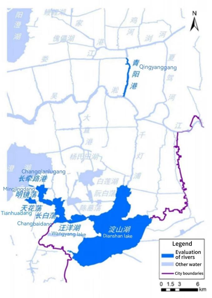
Figure 1. Kunshan City’s Primary River and Lake Systems and Assessment Locations
3. Research methods
3.1. Data collection and sampling site selection
Four field monitoring sessions were conducted in May (spring), July (summer), October (autumn), and December (winter) of 2023 to assess river water quality and biological indicators, as well as to investigate river characteristics such as vegetation and bank slopes. Additionally, in the July survey, sediment samples were collected and monitored at each sampling site. During the investigation period, monitoring data from river water function zone stations and hydrometeorological data were collected simultaneously.
According to DB3205/T 1016-2021, river assessment units should be divided into segments based on different levels of development, habitat characteristics, biological factors, and water function zoning. Monitoring sections should be established accordingly. For lake assessment units, lakes should be partitioned based on these same characteristics, with designated monitoring points set up.
Qingyang Port, which is approximately 8.2 km long, was analyzed based on its hydrological characteristics. One monitoring section was planned approximately every 3 km, ensuring that each section represented different river habitat types (such as varied bank slope morphologies and differences between urban and suburban bank development). Sampling sections were adjusted according to topographical features, ultimately leading to the establishment of three monitoring sections in Qingyang Port. For Changqianlu Port, which is about 2.97 km long, three monitoring sections were also set up. The distribution of river health assessment sampling points in Kunshan City is shown in Figure 2.
For lake assessments, Wangyang Lake (1.79 km²) was assigned three monitoring points; Changbaidang (4.30 km²), three points; Mingjingdang (2.99 km²), three points; Tianhuadang (0.81 km²), three sections; and Dianshan Lake (13.99 km²), four points. The distribution of lake health assessment sampling points in Kunshan City is shown in Figure 3.
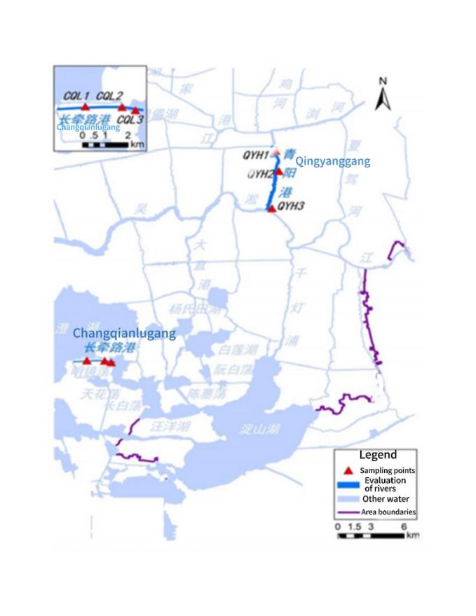
Figure 2. Distribution of River Health Assessment Sampling Points in Kunshan City
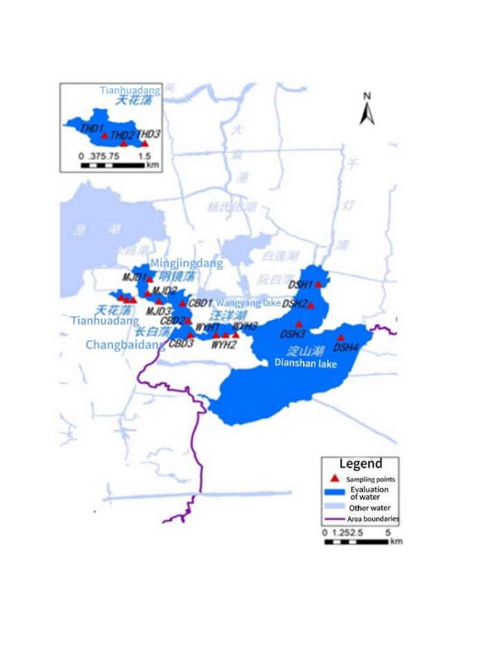
Figure 3. Distribution of Lake Health Assessment Sampling Points in Kunshan City
3.2. Indicator selection
The selected rivers and lakes were assessed in terms of natural ecology, service functions, disturbance levels, and management effectiveness. The assessment covered 13 key elements: river morphology, hydrology and water resources, water quality, aquatic organisms, flood control, water supply security, cultural landscape, public perception, development and utilization, water pollution, spatial regulation, environmental governance, and ecological restoration.
The investigation mainly included the following aspects:
① Water Quality Monitoring and Assessment at Each Sampling Site: Water quality parameters included total nitrogen (TN), total phosphorus (TP), dissolved oxygen (DO), water temperature, ammonia nitrogen, permanganate index, five-day biochemical oxygen demand (BOD₅), transparency, and chlorophyll—a total of nine indicators. In autumn, sediment monitoring was conducted, analyzing TN, TP, total organic matter, and the heavy metals Pb, Zn, Cd, Hg, As, and Cr—nine indicators in total (sediment monitoring was conducted once).
② Biological Survey and Sampling: The study analyzed the distribution structure, biomass, and diversity of plankton, benthic organisms, and periphytic algae (for river sections), evaluating their ecological structure and functional characteristics.
③ Bank Slope and Vegetation Survey: During field investigations, riverbank slope morphology, riparian vegetation, river cross-sections, and plant distribution along the riverbanks and riparian zones were surveyed. The morphological characteristics of riverbank utilization, bank stability, and bank types were recorded. Additionally, the surface water coverage and aquatic plant distribution in lakes were assessed.
④ Drone Aerial Survey: During field investigations, drones were deployed at each river section to capture aerial images, assisting in the assessment of riverbank morphology, vegetation distribution, and bank management conditions.
3.3. Testing methods
3.3.1. Water quality indicators
The testing and analysis methods for water quality samples are shown in Table 1.
Table 1. Overview of Water Quality Indicator Analysis Methods
No. | Item | Testing Method |
1 | Dissolved Oxygen | Electrochemical Probe Method for Water Quality [HJ506-2009] |
2 | Ammonia Nitrogen | Nessler’s Reagent Spectrophotometry for Water Quality [HJ535-2009] |
3 | Total Phosphorus | Ammonium Molybdate Spectrophotometry for Water Quality [GB/T11893-1989] |
4 | Total Nitrogen | Alkaline Persulfate Digestion UV Spectrophotometry for Water Quality [HJ636-2012] |
5 | Permanganate Index | Acidic Potassium Permanganate Method for Water Quality [GB/T11892-1989] |
6 | Chlorophyll-a | Spectrophotometry for Chlorophyll Determination [SL88-2012] |
7 | Transparency | Secchi Disk Method for Transparency Measurement [SL87-1994] |
3.3.2. Sediment indicators
The testing and analysis methods for sediment samples are shown in Table 2.
Table 2. Overview of Sediment Indicator Analysis Methods
No. | Item | Testing Method |
1 | Total Phosphorus | Total Phosphorus Determination in Soil [NY/T88-1988] |
2 | Total Nitrogen | Total Nitrogen Determination in Soil [NY/T53-1987] |
3 | Lead (Pb) | Determination of Lead and Cadmium in Soil by Graphite Furnace Atomic Absorption Spectrophotometry [GB/T17141-1997] |
4 | Cadmium (Cd) | Determination of Lead and Cadmium in Soil by Graphite Furnace Atomic Absorption Spectrophotometry [GB/T17141-1997] |
5 | Zinc (Zn) | Determination of Copper and Zinc in Soil by Flame Atomic Absorption Spectrophotometry [GB/T17141-1997] |
6 | Chromium (Cr) | Determination of Total Chromium in Soil by Flame Atomic Absorption Spectrophotometry [HJ491-2009] |
7 | Mercury (Hg) | Soil Testing - Part 10: Determination of Total Mercury in Soil [NY/T1121.10-2006] |
8 | Arsenic (As) | Soil Testing - Part 11: Determination of Total Arsenic in Soil [NY/T1121.11-2006] |
3.3.3. Biological indicators
The testing and analysis methods for biological samples are shown in Table 3.
Table 3. Overview of Biological Indicator Analysis Methods
No. | Item | Testing Method |
1 | Phytoplankton Density & Biomass | Technical Regulations for Phytoplankton Monitoring in Inland Waters [SL733-2016] |
2 | Periphyton Algae Density & Biomass | Specifications for Reservoir Fishery Resource Investigation [SL167-2016] |
3 | Benthic Macroinvertebrate Density & Biomass | Specifications for Reservoir Fishery Resource Investigation [SL167-2016] |
4 | Macrophyte Biomass | Specifications for Reservoir Fishery Resource Investigation [SL167-2016] |
4. Evaluation results
According to the operability principle outlined in the Guidelines, the health assessment of rivers and lakes is conducted from four perspectives: “Basin,” “Water,” Biology, and Social Service Functions.
4.1. River assessment
4.1.1. Evaluation values and health ratings
For the “Basin” criterion layer, the selected indicators include the natural condition of the shoreline (stability of riverbanks and vegetation coverage) and the degree of unauthorized development and utilization of shoreline areas. Under the “Water” criterion layer, the indicators include the extent to which water levels meet ecological requirements, water quality conditions, sediment pollution levels, and the self-purification capacity of the water body. The biological criterion layer considers large benthic invertebrate biological indices and aquatic plant community conditions as indicators. The social service function criterion layer includes indicators such as flood control compliance rate, water supply guarantee level, shoreline utilization management index, and public satisfaction. In the health assessment system for two rivers within Kunshan—Qingyang Port and Changqianlu Port—12 evaluation indicators were selected across the four criterion layers: “Basin,” “Water,” Biology, and Social Service Functions.
Based on the comprehensive assessment of these 12 river health indicators, both Qingyang Port and Changqianlu Port were rated as “Healthy.” The specific evaluation results are presented in Table 4.
Table 4. Comprehensive River Health Assessment Results
Criterion Layer | Indicator Layer | Qingyang Port | Changqianlu Port | ||||
Indicator Value | Evaluation Result | Indicator Value | Evaluation Result | ||||
“Basin” | Natural Condition of Shoreline | Bank Stability | 97 | Very Healthy | 92 | Healthy | |
Vegetation Coverage | 84.24 | Healthy | 90.25 | Very Healthy | |||
Degree of Unauthorized Shoreline Utilization | 98 | Very Healthy | 85 | Healthy | |||
“Water” | Ecological Water Level Compliance (Water Volume) | 100 | Very Healthy | 100 | Very Healthy | ||
Water Quality Condition (Water Quality) | 85.5 | Class III | 92 | Class II | |||
Sediment Pollution Condition (Water Quality) | Pollution Index | 0.92 | Healthy | 0.91 | Healthy | ||
Heavy Metal Ecological Risk Index | 38.36 | Very Healthy | 39.11 | Very Healthy | |||
Self-Purification Capacity (Water Quality) | 94.53 | Class II | 100 | Class II | |||
Biology | Large Benthic Invertebrate Biological Index | S-W Diversity Index | 1.225 | Unhealthy | 1.559 | Unhealthy | |
OI Index | 0.015 | Very Healthy | 0.016 | Very Healthy | |||
Aquatic Plant Community Condition | Phytoplankton Biological Index | 1.29 | Unhealthy | 1.32 | Unhealthy | ||
Periphyton Biological Index | 2.34 | Subhealthy | 2 | Subhealthy | |||
Social Service Functions | Flood Control Compliance Rate | 100 | Very Healthy | 100 | Very Healthy | ||
Water Supply Guarantee Level | 100 | Very Healthy | 100 | Very Healthy | |||
Shoreline Utilization Management Index | Shoreline Development and Utilization Rate | 31.82 | Unhealthy | 29.03 | Subhealthy | ||
Public Satisfaction | 94.93 | Very Healthy | 95.78 | Very Healthy | |||
4.1.2. Existing issues
The assessment results indicate that Qingyang Port and Changqianlu Port in Kunshan were rated as “Healthy” in 2023. However, several issues and influencing factors persist. Qingyang Port exhibits biodiversity deficiencies, a high shoreline development and utilization rate, and a low proportion of ecological riverbanks. Similarly, Changqianlu Port faces challenges related to poor hydrodynamic connectivity, biodiversity deficiencies, a low proportion of ecological riverbanks, degraded riverbank environments in some sections, and insufficient landscape comfort.
4.2. Lake assessment
4.2.1. Evaluation values and health ratings
For the “Basin” criterion layer, the selected indicators include the natural condition of the lake shoreline and the degree of unauthorized development and utilization of shoreline areas. Under the “Water” criterion layer, the indicators include minimum ecological water level compliance, water quality condition, trophic state of the lake, sediment pollution levels, and the self-purification capacity of the water body. The biological criterion layer considers phytoplankton density and the biological integrity index of large benthic invertebrates as indicators. The social service function criterion layer includes indicators such as flood control compliance rate, shoreline utilization management index, and public satisfaction. In the health assessment system for five lakes within Kunshan, 12 evaluation indicators were selected across the four criterion layers: “Basin,” “Water,” Biology, and Social Service Functions.
Based on the comprehensive assessment of these 12 lake health indicators, Wangyang Lake and Dianshan Lake were rated as “Healthy,” while Changbaidang, Mingjingdang, and Tianhuadang were rated as “Very Healthy.” The specific evaluation results are presented in Table 5.
Table 5. Comprehensive Assessment Results of Lake Health
Criterion Level | Indicator Level | Wangyang Lake | Changbaidang | Mingjingdang | Mingjingdang | Dianshan Lake | ||||||
Indicator Value | Assessment Result | Indicator Value | Assessment Result | Indicator Value | Assessment Result | Indicator Value | Assessment Result | Indicator Value | Assessment Result | |||
“Basin” | Shoreline Natural Conditions | Vegetation Coverage | 85.65 | Healthy | 88.11 | Healthy | 84.06 | Healthy | 83.39 | Healthy | 88.81 | Healthy |
Degree of Unauthorized Shoreline Development | 95 | Very Healthy | 92 | Very Healthy | 94 | Very Healthy | 93 | Very Healthy | 98 | Very Healthy | ||
“Water” | Minimum Ecological Water Level Satisfaction (Water Quantity) | 100 | Very Healthy | 100 | Very Healthy | 100 | Very Healthy | 100 | Very Healthy | 100 | Very Healthy | |
Water Quality Condition (Water Quality) | 61.9 | Class IV | 62.82 | Class IV | 62.91 | Class IV | 65.98 | Class IV | 58.68 | Class IV | ||
Lake Nutritional Status | Nutrient Status Index | 48.61 | Healthy | 49.84 | Healthy | 50.88 | Subhealthy | 51.74 | Subhealthy | 49.98 | Healthy | |
Sediment Pollution Condition (Water Quality) | Pollution Index | 0.87 | Healthy | 0.77 | Healthy | 0.84 | Healthy | 0.64 | Healthy | 0.84 | Healthy | |
Heavy Metal Ecological Risk Index | 21.34 | Very Healthy | 23.22 | Very Healthy | 31.88 | Very Healthy | 31.35 | Very Healthy | 36.12 | Very Healthy | ||
Water Self-Purification Capacity (Water Quality) | 100 | Class I | 100 | Class Ⅰ | 100 | Class I | 100 | Class I | 100 | Class I | ||
Biological | Integrity Index of Macrozoobenthos | S-W Diversity Index | 1.584 | Unhealthy | 1.51 | Unhealthy | 1.431 | Unhealthy | 1.527 | Unhealthy | 1.531 | Unhealthy |
OI Index | 0.046 | Very Healthy | 0.018 | Very Healthy | 0.117 | Very Healthy | 0.137 | Very Healthy | 0.118 | Very Healthy | ||
Phytoplankton Density | Cyanobacteria Density | 31.4 | Very Healthy | 178.33 | Very Healthy | 17.2 | Very Healthy | 34.65 | Very Healthy | 77.3 | Very Healthy | |
Social Service Functions | Flood Control Compliance Rate | 100 | Very Healthy | 100 | Very Healthy | 100 | Very Healthy | 100 | Very Healthy | 100 | Very Healthy | |
Shoreline Utilization Management Index | Shoreline Development Utilization Rate | 10.58 | Subhealthy | 6.07 | Healthy | 11.14 | Subhealthy | 13.95 | Subhealthy | 10.75 | Subhealthy | |
Public Satisfaction | 96.19 | Very Healthy | 96.04 | Very Healthy | 97.11 | Very Healthy | 95.5 | Very Healthy | 96.03 | Very Healthy | ||
4.2.2. Existing issues
The lake assessment results indicate that Wangyang Lake and Dianshan Lake are classified as “Healthy,” while Changbaidang, Mingjingdang, and Tianhuadang are categorized as “Very Healthy.” The factors affecting the health status of these five lakes are largely common. Notably, low values of benthic biodiversity (Shannon-Wiener index) and water quality indicators are significant influencing factors. Additionally, both Mingjingdang and Tianhuadang exhibit mild eutrophication, which also plays a crucial role. Some lakes show slightly higher levels of shoreline development. Wangyang Lake experiences a higher presence of floating oil slicks in summer, and Dianshan Lake has a low proportion of ecological shorelines.
5. Conclusion
5.1. Rivers
The assessed Qingyang Port and Changqianlu Port serve critical functions in flood control, drainage, navigation, and landscape enhancement, playing an important role in regional economic development. The assessment indicates that both rivers share common issues, including low aquatic biodiversity and a low proportion of ecological shore slopes. Additionally, Changqianlu Port has limited water flow, with some riverbanks experiencing encroachment for farming, minor littering, and small-scale poultry enclosures. Based on field investigations and assessment results, the following recommendations are proposed:
(1) Increase the coverage of riparian aquatic vegetation to improve riverbank ecological conditions and enhance the riparian habitat.
Field surveys show that Qingyang Port is navigable, with its banks predominantly consisting of hardened shorelines, while Changqianlu Port also has a high proportion of hardened shorelines and limited riparian aquatic vegetation. However, both rivers contain patches of aquatic vegetation, with shallow waters along Qingyang Port’s riverbanks supporting aquatic plants. It is recommended to restore aquatic vegetation in shallow riparian areas while ensuring the navigability and flood discharge functions of the rivers, thereby rehabilitating riparian ecological habitats.
(2) Strengthen the environmental management of Changqianlu Port’s shore slopes to improve river aesthetics and enhance environmental comfort.
Some sections of Changqianlu Port pass through densely populated residential areas, making environmental management challenging. While the overall water and shoreline conditions are satisfactory, some riverbanks still suffer from unauthorized farming, littering, and poultry enclosures. It is recommended to enhance routine management efforts, including riverbank monitoring, patrols, maintenance, and surface water cleaning, particularly in concealed areas such as under bridges and in densely populated residential zones. Additionally, efforts should focus on highlighting cultural landscapes, incorporating appropriate water-friendly facilities, and maintaining waterbank sanitation. Public awareness campaigns on the importance of river conservation should be conducted to foster environmental consciousness among residents and encourage community participation in river protection.
(3) Improve water flow conditions in Changqianlu Port.
The assessment indicates that Changqianlu Port has limited water flow, with lower water transparency observed in densely populated sections. Due to localized pollution and water stagnation in these areas, there is a risk of further ecological degradation. It is recommended to increase ecological water flow where feasible, ensuring that flood discharge functions remain unaffected. Additionally, aeration techniques or similar measures could be implemented in densely populated river segments to enhance water circulation and improve dynamic aquatic habitat conditions.
5.2. Lakes
The five assessed lakes—Wangyang Lake, Changbaidang, Mingjingdang, Tianhuadang, and Dianshan Lake—offer essential functions such as flood control, water storage, ecological conservation, aquaculture, and scenic value. Some of these lakes feature picturesque landscapes and have been developed into water conservancy scenic areas. The assessment identifies key concerns, including high nitrogen (N) and phosphorus (P) concentrations (particularly high total nitrogen levels in Dianshan Lake), inadequate surface water cleanliness in certain lakes (e.g., oil pollution in Wangyang Lake during summer), eutrophication issues, and a low proportion of ecological shore slopes in Dianshan Lake. Based on field investigations and assessment findings, the following recommendations are proposed:
(1) Continue implementing water pollution prevention measures to reduce N and P concentrations and mitigate lake eutrophication.
The assessment shows that total phosphorus (TP) levels in all five lakes correspond to Class IV water quality, with total nitrogen (TN) in Dianshan Lake classified as Class V and the remaining four lakes as Class IV. Mingjingdang and Tianhuadang exhibit mild eutrophication. To curb further eutrophication, stringent control measures on nitrogen and phosphorus inflow are necessary. Apart from Dianshan Lake, the lakeshores of the remaining four lakes are largely surrounded by farmland, necessitating stronger control over rural domestic pollution and non-point source pollution. Given the predominant agricultural land use around the lakes and the complex connectivity of surrounding water systems, particular attention should be paid to intercepting pollutants from inflowing rivers and agricultural runoff. Additionally, efforts should continue to improve wastewater interception systems in nearby rural settlements.
(2) Enhance shoreline environmental management to restore the ecological buffering capacity of lakefront areas.
Although the overall shoreline conditions of the five lakes are relatively good, some areas exhibit unauthorized farming and straw accumulation along the banks. While most lake shorelines have well-preserved aquatic vegetation and wetlands, these disturbances still significantly affect water quality and habitat conditions. Strengthening shoreline and wetland conservation and restoration efforts is recommended, with particular attention to reducing shoreline farming activities. Dianshan Lake has a high proportion of hardened shorelines and limited aquatic vegetation. Therefore, efforts should be made to restore aquatic plant coverage along the lakefront and promote the development of surrounding ecological wetlands. Establishing a comprehensive green ecological corridor around the lake would help restore riparian buffering functions while complementing local development initiatives, ultimately integrating ecological conservation with tourism and cultural landscape enhancement.
(3) Address the issue of floating oil pollution in Wangyang Lake.
During the assessment, significant floating oil pollution was observed in parts of Wangyang Lake during summer. Given the complexity of surrounding water system connectivity, residential activities, shoreline development, and industrial factors, further investigation is needed to identify potential sources of pollution input and internal contamination. Strengthened measures should be taken to ensure long-term lake ecological protection and improvement.
References
[1]. Wang, X., Fu, J., Dai, J., et al. (2020). Case analysis of river and lake healthy evaluation. China Water Resources, (20), 11-13.
[2]. Liu, J. (2024). A brief discussion on the construction of river and lake water ecology healthy system. In Proceedings of the 12th China Water Ecology Conference (pp. 6). River and Estuary Research Institute of Hohai University, Zhejiang Provincial Water Conservancy Society. https://doi.org/10.26914/c.cnkihy.2024.039763
[3]. Wang, S. (2010). The issue of water resource security in China and countermeasures. Geography Teaching, (01), 4-7.
[4]. Yu, Z., Hu, Z., Wu, J., et al. (2019). Research on the current situation, hazards, and treatment measures of water pollution in China. Environmental Protection and Development, 31(06), 61+63. https://doi.org/10.16647/j.cnki.cn15-1369/X.2019.06.038
[5]. Li, Y., Li, C., Wang, X., et al. (2020). The construction and reflection of the river and lake healthy evaluation index system. China Water Resources, (20), 4-7.
[6]. Liu, L., Li, Y., & Wang, X. (2020). The background and significance of the implementation of the “River and Lake Healthy Evaluation Guidelines (Trial)”. China Water Resources, (20), 1-3.
[7]. Chen, J., He, X., Cai, G., et al. (2021). The work goals and countermeasures of river and lake healthy evaluation based on the river and lake chief system. Water Resources Development Research, 21(06), 34-37. https://doi.org/10.13928/j.cnki.wrdr.2021.06.008
[8]. Yu, K., Cai, Q., Zhao, W., et al. (2024). The application of river and lake healthy archives in the healthy evaluation of Yangcheng Lake. Jiangsu Water Resources, (07), 21-24. https://doi.org/10.16310/j.cnki.jssl.2024.07.003
Cite this article
Bo,Y.;Hu,J.;Wang,W.;Cai,Q.;Liang,T. (2025). 2023 Kunshan river and lake health assessment. Advances in Engineering Innovation,16(1),76-84.
Data availability
The datasets used and/or analyzed during the current study will be available from the authors upon reasonable request.
Disclaimer/Publisher's Note
The statements, opinions and data contained in all publications are solely those of the individual author(s) and contributor(s) and not of EWA Publishing and/or the editor(s). EWA Publishing and/or the editor(s) disclaim responsibility for any injury to people or property resulting from any ideas, methods, instructions or products referred to in the content.
About volume
Journal:Advances in Engineering Innovation
© 2024 by the author(s). Licensee EWA Publishing, Oxford, UK. This article is an open access article distributed under the terms and
conditions of the Creative Commons Attribution (CC BY) license. Authors who
publish this series agree to the following terms:
1. Authors retain copyright and grant the series right of first publication with the work simultaneously licensed under a Creative Commons
Attribution License that allows others to share the work with an acknowledgment of the work's authorship and initial publication in this
series.
2. Authors are able to enter into separate, additional contractual arrangements for the non-exclusive distribution of the series's published
version of the work (e.g., post it to an institutional repository or publish it in a book), with an acknowledgment of its initial
publication in this series.
3. Authors are permitted and encouraged to post their work online (e.g., in institutional repositories or on their website) prior to and
during the submission process, as it can lead to productive exchanges, as well as earlier and greater citation of published work (See
Open access policy for details).
References
[1]. Wang, X., Fu, J., Dai, J., et al. (2020). Case analysis of river and lake healthy evaluation. China Water Resources, (20), 11-13.
[2]. Liu, J. (2024). A brief discussion on the construction of river and lake water ecology healthy system. In Proceedings of the 12th China Water Ecology Conference (pp. 6). River and Estuary Research Institute of Hohai University, Zhejiang Provincial Water Conservancy Society. https://doi.org/10.26914/c.cnkihy.2024.039763
[3]. Wang, S. (2010). The issue of water resource security in China and countermeasures. Geography Teaching, (01), 4-7.
[4]. Yu, Z., Hu, Z., Wu, J., et al. (2019). Research on the current situation, hazards, and treatment measures of water pollution in China. Environmental Protection and Development, 31(06), 61+63. https://doi.org/10.16647/j.cnki.cn15-1369/X.2019.06.038
[5]. Li, Y., Li, C., Wang, X., et al. (2020). The construction and reflection of the river and lake healthy evaluation index system. China Water Resources, (20), 4-7.
[6]. Liu, L., Li, Y., & Wang, X. (2020). The background and significance of the implementation of the “River and Lake Healthy Evaluation Guidelines (Trial)”. China Water Resources, (20), 1-3.
[7]. Chen, J., He, X., Cai, G., et al. (2021). The work goals and countermeasures of river and lake healthy evaluation based on the river and lake chief system. Water Resources Development Research, 21(06), 34-37. https://doi.org/10.13928/j.cnki.wrdr.2021.06.008
[8]. Yu, K., Cai, Q., Zhao, W., et al. (2024). The application of river and lake healthy archives in the healthy evaluation of Yangcheng Lake. Jiangsu Water Resources, (07), 21-24. https://doi.org/10.16310/j.cnki.jssl.2024.07.003