


1. Introduction
Under the dual-carbon policy framework, the carbon sink capacity of urban ecosystems has emerged as a critical focus in global climate governance. As a key component of natural carbon sinks, urban green spaces not only provide vital ecosystem services such as microclimate regulation and air purification but also play an irreplaceable role in balancing carbon emissions within dense urban areas [1]. However, existing carbon sink estimation methods face significant challenges in addressing the spatiotemporal heterogeneity, complex land composition, and rapid land-use transitions of urban environments [2]. On one hand, traditional ground-based surveys and empirical regression approaches suffer from high labor costs, limited spatial coverage, and unstable estimation accuracy [3]. On the other hand, although remote sensing technologies offer multi-source, multi-scale, and multi-temporal observations, most mainstream models rely heavily on vegetation indices or statistical learning techniques, lacking the capacity to capture nonlinear dynamics and temporal evolution of urban carbon storage [4]. This is particularly problematic in urban settings where green spaces are fragmented, have ambiguous boundaries, and are subject to frequent anthropogenic disturbance. As a result, simple methods often fail to deliver high-resolution and high-confidence carbon sink estimates. There is thus an urgent need for an intelligent estimation framework capable of joint spatiotemporal modeling and deep feature extraction from heterogeneous remote sensing data, to support accurate carbon sink accounting in urban green spaces and enable the operationalization of carbon asset management.
2. Literature review
2.1. Current studies on urban carbon sinks
Studies on urban green carbon sinks primarily focus on the function of urban green space, especially carbon sinks. This kind of ability is achieved by biomass estimation and carbon stock simulation, which are attained from field surveys [5]. For example, carbon concentration can be calculated from stem diameter or crown width by empirical formulas. It is unsuitable to widely apply this method for its low-efficiency and high-input [6]. Meanwhile, cities have different types of land use cover and complicated human intervention, thus the suitability of empirical formulas in cities is low. Studies have tried to import GIS databases like NDVI, Urban Green Space Map to evaluate the carbon concentration of urban green space. Even though they address the weakness of manual measurement, they remain constrained by several issues like slow temporal updates, insufficient resolution and poor model adaptability [7]. However, they lack the capacity to model spatiotemporal dynamics across heterogeneous urban environments.
2.2. Applications of remote sensing in carbon estimation
Remote sensing can extract large-scale variation of urban green space from satellite imaginary, including vegetation health, distribution density and coverage area. It also enables large-scale ecological monitoring through vegetation indices like NDVI and EVI [8]. Yet, these indices merely reflect the plant situation, instead of how much carbon does plant intake. Research used linear regression to study the relationship between NDVI and carbon storage, but this model is easily affected by outliers and has limited applicability [9]. Also, these approaches depend on empirical parameters and lack robustness in complex urban settings.
2.3. Deep learning for remote sensing fusion
Recent advances in CNNs, LSTMs, and fusion networks have improved remote sensing interpretation. CNNs help to extract more diverse spatial characteristics from satellite imaginary, while temporal models like LSTM do help to understand the tendency of carbon stock in certain areas as time goes by [10]. Multi-source fusion models enhance prediction accuracy and temporal resolution, offering new opportunities for carbon sink modeling. More importantly, deep learning models are capable of non-linear mapping and end-to-end mapping, without the need for extensive manual definition of rules. Instead, they automatically identify the underlying pattern of urban green space carbon sequestration through training, which make a difference in complicated landform, urban micro-climate and seasonal variation [11]. As a result, it is important to immerge remote sensing and deep learning to achieve high-accurate carbon storage evaluation
3. Experimental methods
3.1. Data collection and preprocessing
In this study, the city of Guangzhou, China, is taken as the study area. Controlled by subtropical monsoon climate, Guangzhou has high greening rates, including encompassing parklands, protective forest belts, roadside vegetation, ancillary greenspaces and natural wetlands. It is an ideal research subject for land type diversity and temporal variation. The remote sensing data sources include Landsat-8 OLI/TIRS, Sentinel-2 MSI, and MODIS Terra/Aqua, with the temporal range covering 2018 to 2023, and the spatial resolutions of 30m, 10m, and 500m, respectively. The data are unified by atmospheric corrections (using Sen2Cor and LEDAPS), resampling and geometric alignment, and the analysis area is divided based on the ecological green map of Guangzhou, which provides a consistent and high data basis for the subsequent modelling. Through atmospheric correction (using Sen2Cor and LEDAPS), resampling and geometric alignment, the temporal frequency and spatial scale of the multi-source images are unified, and the analysis area is divided based on the ecological green map of Guangzhou City, which provides a consistent database for subsequent modelling.
3.2. Model architecture
The proposed model adopts a deep spatiotemporal fusion framework consisting of three components: (1) a spatial feature extraction module based on Convolutional Neural Networks (CNNs), (2) a temporal modeling module based on Temporal Convolutional Networks (TCNs), and (3) a final regression layer for carbon sink estimation. The CNN module uses multiscale convolution kernels to extract spatial patterns such as vegetation texture, boundary morphology, and patch connectivity from satellite images. Let the input remote sensing image at region rrr and time ttt be Xr,t, the spatial feature output can be formulated as:
Where wi represents the weight of the i-th convolutional filter, b is the bias term, and Fs denotes the resulting spatial feature map.
The extracted spatial features are then passed to a 1D dilated TCN module, which is capable of modeling long-range temporal dependencies across multiple years and seasons. The temporal feature extraction is expressed as:
Where
The fusion of spatial and temporal representations is fed into a fully connected regression layer, which outputs the predicted carbon sink value per pixel in units of tons of carbon per hectare. The overall framework supports end-to-end training and allows efficient handling of large-scale, heterogeneous, and multi-temporal remote sensing inputs. It is particularly suitable for dynamic estimation of urban green space carbon sink capacity with high spatiotemporal fidelity.
3.3. Training and evaluation
This model is trained using a supervised learning framework, with the objective of minimizing the error between the predicted carbon sink values and the actual observed values. The samples are generated through spatial stratified random sampling to maintain category diversity and spatial independence, and are divided into training set, validation set and test set in a ratio of 7:2:1.
Model training is conducted using the Adam optimizer with an initial learning rate of 1×10⁻⁴, and an L2 regularization weight decay factor of 1×10⁻⁵ to mitigate overfitting. Early stopping is employed based on the validation loss to avoid unnecessary iterations. The primary loss function is Mean Squared Error (MSE), expressed as:
Where
To comprehensively evaluate the performance of the model, four indicators were introduced: root mean square error (RMSE), mean absolute error (MAE), coefficient of determination (R2), and structural similarity index (SSIM). These indicators were used to assess the model from multiple dimensions such as error magnitude, fitting ability, and image consistency. Additionally, to test the stability and generalization ability of the model, group experiments were conducted under different types of green spaces (such as parks, forest belts, and affiliated green spaces), different seasons (spring, summer, autumn, winter), and different remote sensing sources (Sentinel-2 and MODIS).
4. Results
4.1. Estimation accuracy and interpretability
In the experiment of carbon sink estimation for urban green spaces, the CNN-TCN deep fusion model proposed in this paper demonstrated excellent performance across multiple evaluation metrics, showcasing high estimation accuracy and stable spatiotemporal modeling capabilities. In the test set, the overall root mean square error (RMSE) of the model was 2.71 tC/ha, the mean absolute error (MAE) was 1.94 tC/ha, the determination coefficient (R²) was 0.926, and the structural similarity index (SSIM) was 0.841, indicating that the model has a high fitting ability and spatial consistency. The carbon storage dynamic change trend of the model in different periods was highly consistent with the actual vegetation growth cycle in Guangzhou, and it could capture the typical seasonal characteristics of spring growth, summer plateau, and autumn-winter decline.
From the land use classification perspective, there were significant differences in the estimation accuracy of different types of green spaces. Urban park green spaces had the highest prediction accuracy due to their regular shapes and stable vegetation coverage, with an RMSE of 1.63 tC/ha; ecological protection forest belts were relatively continuous in space, with an RMSE of 2.09 tC/ha; while traffic isolation belts had a lower coverage rate, ambiguous boundaries, and mixed with non-green space pixels, resulting in relatively larger errors, with an RMSE of 3.21 tC/ha. Table 1 shows the main evaluation index performance of the model under different green space types.
|
Green Space Type |
RMSE (tC/ha) |
MAE (tC/ha) |
R² |
SSIM |
|
Urban Park Green Space |
1.63 |
1.25 |
0.945 |
0.864 |
|
Shelterbelt Forest |
2.09 |
1.68 |
0.918 |
0.832 |
|
Wetland Green Area |
2.54 |
2.03 |
0.902 |
0.811 |
|
Auxiliary Green Space |
2.78 |
2.22 |
0.881 |
0.793 |
|
Roadside Isolation Belt |
3.21 |
2.64 |
0.856 |
0.751 |
|
Overall Average |
2.71 |
1.94 |
0.926 |
0.841 |
4.2. Model comparison
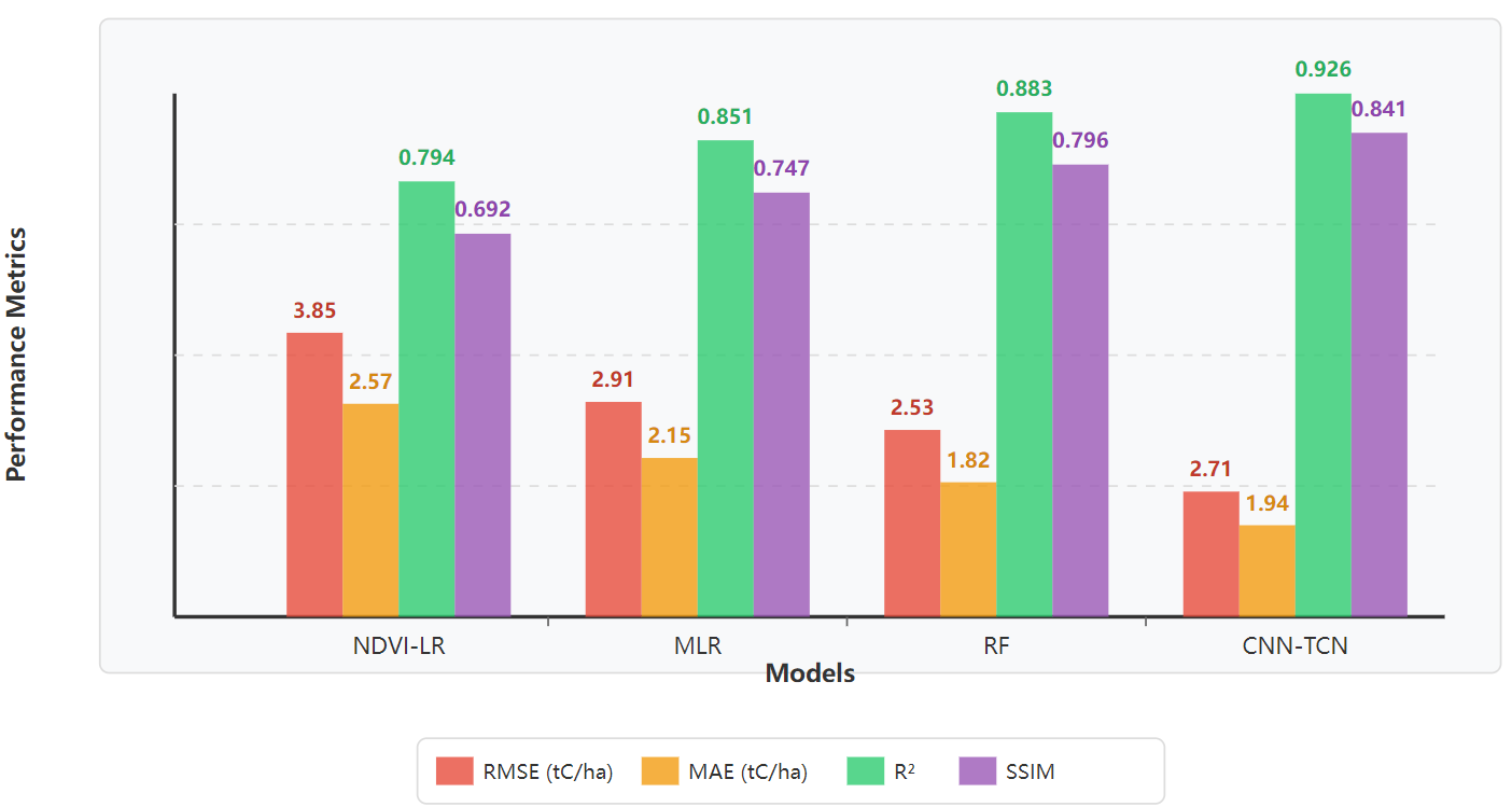
To fully verify the advantages of the CNN-TCN model proposed in this paper in estimating urban green space carbon sequestration, a comparative experiment was designed against three benchmark models: the vegetation index regression model (NDVI-LR), the multiple linear regression model (MLR), and the random forest regression model (RF). The comparison mainly focused on four performance indicators. All tests were conducted under the same remote sensing samples and time periods to ensure fairness and comparability. The results showed that the CNN-TCN model achieved the best performance in all four indicators: RMSE was 2.71 tC/ha, MAE was 1.94 tC/ha, R² was 0.926, and SSIM was 0.841. In contrast, NDVI-LR had RMSE and MAE of 3.85 and 2.57 respectively, and R² was only 0.794, which was significantly lower than the deep model. While MLR and RF showed some improvement, they still performed inadequately in handling temporal changes and heterogeneous land types. Figure 1 shows the performance change curves of each model under the four indicators. It can be seen that the CNN-TCN model was always in the best performance position, and the improvement on the SSIM curve was particularly significant, indicating its strong advantage in restoring the spatial structure of carbon sequestration.
5. Discussion
The proposed deep spatiotemporal fusion model demonstrates high accuracy, stability, and adaptability in estimating urban green-space carbon sink capacity. Experimental results show that it consistently outperforms traditional statistical and machine learning models in terms of error control (RMSE, MAE), and achieves superior structural similarity (SSIM), indicating enhanced capacity in capturing green-space boundaries and morphological features within heterogeneous urban environments. Particularly in fragmented urban interiors and diverse suburban forest belts, the model effectively recognizes spatial heterogeneity and supports multi-scale ecological planning. However, prediction fluctuations persist in low-coverage or highly disturbed regions such as roadside belts and temporary vegetation zones, suggesting that future work could incorporate higher-resolution imagery (e.g., WorldView-3 or GF-series) for localized refinement. Additionally, although the model is trained on a five-year multi-temporal dataset and shows strong seasonal response, it remains fundamentally data-driven and lacks integration with ecological process models. Future research may explore hybrid frameworks that integrate data-driven learning with mechanistic models (e.g., CASA or InVEST), enhancing interpretability and decision support for urban ecological management and policy formulation.
6. Conclusion
This study proposes a deep spatiotemporal remote-sensing fusion framework that integrates Convolutional Neural Networks (CNN) and Temporal Convolutional Networks (TCN) to achieve high-precision, dynamic estimation of urban green-space carbon sink capacity. Using Guangzhou as the case study, a multi-source dataset combining Sentinel-2, Landsat-8, and MODIS imagery was constructed. The model leverages end-to-end spatial feature extraction and temporal modeling to significantly improve estimation accuracy and spatial consistency. It demonstrates strong robustness and generalizability across diverse land cover types and seasonal conditions, particularly excelling in structural preservation and dynamic carbon response. Compared to traditional statistical and machine learning methods, the proposed framework achieves superior performance in error control, structural fidelity, and regional adaptability, validating its practical value in complex urban environments. Future applications may include carbon neutrality trajectory simulations, ecological compensation assessments, and fine-scale green infrastructure management, particularly when integrated with ecological process models and policy-oriented parameters to support intelligent carbon asset governance.
References
[1]. Wang, R.-Y., Wu, Z., Li, X., Shi, T. M., Liu, X., Chen, L., ... & Ye, Z. (2024). Comparison of the CASA and InVEST models’effects for estimating spatiotemporal differences in carbon storage of green spaces in megacities.Scientific Reports, 14(1), 5456.
[2]. Wu, Z., Jiang, M., Li, H., Shen, Y., Song, J., Zhong, X., & Ye, Z. (2023). Urban carbon stock estimation based on deep learning and UAV remote sensing: a case study in Southern China.All Earth, 35(1), 272–286.
[3]. Li, X., Wu, Z., Wang, R.-Y., Huang, J., Pan, B., Zurita, J. V. S., ... & Tuzikov, A. (2024). The impact of landscape spatial morphology on green carbon sink in the urban riverfront area.Cities, 148, 104919.
[4]. Shi, T. M., Wu, Z., Li, X., Wang, R.-Y., Liu, X., Chen, L., ... & Ye, Z. (2025). Evaluation of Urban Composite Carbon Sink Value: A Case Study of Shenyang.Landscape Architecture, 32, 57–66.
[5]. Liu, X., Wu, Z., Li, X., Wang, R.-Y., Shi, T. M., Chen, L., ... & Ye, Z. (2025). Research on Carbon Sequestration Capacity of Urban Park Green Space in the Central Urban Area of Beijing and Driving Factors Thereof.Landscape Architecture, 32(1), 32–40.
[6]. Chen, L., Wu, Z., Li, X., Wang, R.-Y., Shi, T. M., Liu, X., ... & Ye, Z. (2024). Carbon storage estimation and strategy optimization under low carbon objectives for urban attached green spaces.Science of The Total Environment, 923, 171507.
[7]. Wu, Z., Jiang, M., Li, H., Shen, Y., Song, J., Zhong, X., & Ye, Z. (2023). Urban carbon stock estimation based on deep learning and UAV remote sensing: a case study in Southern China.All Earth, 35(1), 272–286.
[8]. Li, R., Ye, S., Bai, Z., Nedzved, A., & Tuzikov, A. (2024). Moderate Red-Edge vegetation index for High-Resolution multispectral remote sensing images in urban areas.Ecological Indicators, 167, 112645.
[9]. Huang, J., Wu, Z., Li, X., Wang, R.-Y., Shi, T. M., Liu, X., ... & Ye, Z. (2024). Carbon Sequestration and Landscape Influences in Urban Greenspace Coverage Variability: A High-Resolution Remote Sensing Study in Luohe, China.Forests, 15(11), 1849.
[10]. Zurita, J. V. S., Wu, Z., Li, X., Wang, R.-Y., Shi, T. M., Liu, X., ... & Ye, Z. (2024). Economic valuation of carbon sequestration in Quito’s Metropolitan Park using Sentinel-2 and neural networks.Sapienza: International Journal of Interdisciplinary Studies, 5(3), e24059.
[11]. Pan, B., Wu, Z., Li, X., Wang, R.-Y., Shi, T. M., Liu, X., ... & Ye, Z. (2023). A CNN–LSTM machine-learning method for estimating particulate organic carbon from remote sensing in lakes.Sustainability, 15(17), 13043.
Cite this article
Jiang,P. (2025). High-precision estimation of urban green-space carbon sink capacity via deep spatiotemporal remote-sensing fusion. Advances in Engineering Innovation,16(10),9-13.
Data availability
The datasets used and/or analyzed during the current study will be available from the authors upon reasonable request.
Disclaimer/Publisher's Note
The statements, opinions and data contained in all publications are solely those of the individual author(s) and contributor(s) and not of EWA Publishing and/or the editor(s). EWA Publishing and/or the editor(s) disclaim responsibility for any injury to people or property resulting from any ideas, methods, instructions or products referred to in the content.
About volume
Journal:Advances in Engineering Innovation
© 2024 by the author(s). Licensee EWA Publishing, Oxford, UK. This article is an open access article distributed under the terms and
conditions of the Creative Commons Attribution (CC BY) license. Authors who
publish this series agree to the following terms:
1. Authors retain copyright and grant the series right of first publication with the work simultaneously licensed under a Creative Commons
Attribution License that allows others to share the work with an acknowledgment of the work's authorship and initial publication in this
series.
2. Authors are able to enter into separate, additional contractual arrangements for the non-exclusive distribution of the series's published
version of the work (e.g., post it to an institutional repository or publish it in a book), with an acknowledgment of its initial
publication in this series.
3. Authors are permitted and encouraged to post their work online (e.g., in institutional repositories or on their website) prior to and
during the submission process, as it can lead to productive exchanges, as well as earlier and greater citation of published work (See
Open access policy for details).
References
[1]. Wang, R.-Y., Wu, Z., Li, X., Shi, T. M., Liu, X., Chen, L., ... & Ye, Z. (2024). Comparison of the CASA and InVEST models’effects for estimating spatiotemporal differences in carbon storage of green spaces in megacities.Scientific Reports, 14(1), 5456.
[2]. Wu, Z., Jiang, M., Li, H., Shen, Y., Song, J., Zhong, X., & Ye, Z. (2023). Urban carbon stock estimation based on deep learning and UAV remote sensing: a case study in Southern China.All Earth, 35(1), 272–286.
[3]. Li, X., Wu, Z., Wang, R.-Y., Huang, J., Pan, B., Zurita, J. V. S., ... & Tuzikov, A. (2024). The impact of landscape spatial morphology on green carbon sink in the urban riverfront area.Cities, 148, 104919.
[4]. Shi, T. M., Wu, Z., Li, X., Wang, R.-Y., Liu, X., Chen, L., ... & Ye, Z. (2025). Evaluation of Urban Composite Carbon Sink Value: A Case Study of Shenyang.Landscape Architecture, 32, 57–66.
[5]. Liu, X., Wu, Z., Li, X., Wang, R.-Y., Shi, T. M., Chen, L., ... & Ye, Z. (2025). Research on Carbon Sequestration Capacity of Urban Park Green Space in the Central Urban Area of Beijing and Driving Factors Thereof.Landscape Architecture, 32(1), 32–40.
[6]. Chen, L., Wu, Z., Li, X., Wang, R.-Y., Shi, T. M., Liu, X., ... & Ye, Z. (2024). Carbon storage estimation and strategy optimization under low carbon objectives for urban attached green spaces.Science of The Total Environment, 923, 171507.
[7]. Wu, Z., Jiang, M., Li, H., Shen, Y., Song, J., Zhong, X., & Ye, Z. (2023). Urban carbon stock estimation based on deep learning and UAV remote sensing: a case study in Southern China.All Earth, 35(1), 272–286.
[8]. Li, R., Ye, S., Bai, Z., Nedzved, A., & Tuzikov, A. (2024). Moderate Red-Edge vegetation index for High-Resolution multispectral remote sensing images in urban areas.Ecological Indicators, 167, 112645.
[9]. Huang, J., Wu, Z., Li, X., Wang, R.-Y., Shi, T. M., Liu, X., ... & Ye, Z. (2024). Carbon Sequestration and Landscape Influences in Urban Greenspace Coverage Variability: A High-Resolution Remote Sensing Study in Luohe, China.Forests, 15(11), 1849.
[10]. Zurita, J. V. S., Wu, Z., Li, X., Wang, R.-Y., Shi, T. M., Liu, X., ... & Ye, Z. (2024). Economic valuation of carbon sequestration in Quito’s Metropolitan Park using Sentinel-2 and neural networks.Sapienza: International Journal of Interdisciplinary Studies, 5(3), e24059.
[11]. Pan, B., Wu, Z., Li, X., Wang, R.-Y., Shi, T. M., Liu, X., ... & Ye, Z. (2023). A CNN–LSTM machine-learning method for estimating particulate organic carbon from remote sensing in lakes.Sustainability, 15(17), 13043.