


1 Introduction
Minister Henri Eyebe Ayissi wants to mark a real qualitative leap in terms of modernization of the land sector. Several actions have already been carried out, in particular discussions aimed at facilitating land management. The latter gives a glimpse of the rehashing, reveals an abundant literature and a concrete implementation, in sharp contrast with what is observed in land in Cameroon. From then on, it is easy to understand that the question of land management quickly became the subject of significant reflection with various contributions, being the subject of several seminar proceedings. This is how the Cameroonian State, through the strategy document for growth and employment 2010-2020, known as DSCE (Strategy Document for Growth and Employment), takes a setof measures which will make it an emerging country in 2035 with emphasis on land management and protection. However, land asset management in Cameroon suffers from many problems such as the complexity of organizing the storage and updating of data, as well as reliable access to land information. Faced with this observation and aiming to strengthen the management of land assets within MINDCAF premises, and allow external users to have access to land information, a GIS visualization tool and a web platform have been set up. Furthermore, a centralized platform for dissemination and access to geospatial data which brings together the functionalities of a Geographic Information System (GIS) consultable by ArcGIS, QGIS and online software has been set up. It allows interactive visualization of maps, search and analysis of specific data from the cadastral map, access to various geographic layers and its detailed information. GIS facilitates informed decision-making and its use within MINDCAF by providing users with valuable geographic tools and information. Consequently, the main objective of this study aims to design and develop a Database making it possible to centralize information on the Land Title, the position geographical, on all Land Titles held by MINDCAF by providing a user-friendly interface for spatial analysis, this tool aims to strengthen the visibility of land assets. easy and quick consultation of information according to authorizations, updating of data, downloading in different formats, visualization and analysis on interactive maps, detection of anarchic occupations and land risks, spatial and attribute queries, generating custom maps, as well as editing reports and statistics using dynamic dashboards and charts.
2 Methodology
The methodology adopted began with the choice of the pilot area and the identification of needs. Then, we proceeded with the acquisition and processing of the data, as well as their modeling. Subsequently, we chose the appropriate technologies and architecture. Finally, we have started the development of GIScartography and GISweb.
2.1 Choice of site.
In order to carry out this study, it is necessary to choose a pilot area to test and evaluate the effectiveness of our GIS. The selection criteria include the availability and quality of Land data, the diversity of the assets, the interest for the stakeholders and the technical and financial feasibility. The TALLA District located in the Kribi I district, Ocean Department, SOUTH Region was chosen as a pilot area because of its size, its accessibility, the diversity of its land assets and the availability of data Cadastral.
2.2 Identification of needs.
To identify the key functionalities to integrate into our GIS, it is important to collect and analyze the needs of the actors involved in land asset management. We therefore conducted interviews with the various services concerned (land conservation and Land Registry). At the end of these exchanges, the main needs are as follows: to have a centralized, reliable and up-to-date database on MINDCAF's land assets, allowing easy and rapid consultation of information according to authorizations, updating update of the data, the speed in the output of certificates of property, improves the information provided by the certificate of ownership, downloading in different formats, visualization and analysis on interactive maps, facilitating the dissemination of data on the web, detection of risks and land problems, spatial queries and attributes, the generation of personalized maps, as well as the edition of reports.
2.3 Acquisition and processing.
The spatial data used in the acquisition process to implement our GIS comes from the cadastral map of the Kribi updating office. The spatial data source required specific processing such as the restructuring of the data into layers of our cadastral map, the information of the TFs in the ArcGIS attribute table, the design of a Database, the configuration of our cartography space. Once this spatial data has been acquired, attributes are added to provide information about the geographic objects. These attributes are extracted from land registers and include cadastral information for each land title or element occupied in the cadastral map.
2.4 Data modelling.
From the data collected, data modeling was carried out firstly using Autocad and ArcGIS software to implement our cartographic space and secondly, we used the MERISE method which manages the spatial data. and non-spatial, the GeoServer map server to distribute spatial data stored in PostgreSQL, the Apache http Server web server to host the map space and manage the data, and sublime text to develop the SIGWEB user interface. As for programming languages, HTML was used for page structure, CSS with Bootstrap for formatting, JavaScript with jQuery and OpenLayers for web and map interactivity, PHP for server side and interact with the database, SQL for managing queries and data manipulations, and AJAX for dynamic content updates without page reloading characterized by a four-level approach including the data dictionary, the Conceptual Data Model, the Logical Data Model and the Physical Data Model.
3 RESULTS
3.1 Presentation of the area of study.
Our study area is located about 10 minutes from the city center, south of the Diocese, 1 km from the Main Axis Mboamanga, Talla, Pangoue, it is located between Mpangou and Mboamanga de Kribi at a place called Talla, in the district of Kribi 1st, Ocean Department, South Region. The project site is located within the perimeter of the Urban Community of Kribi.
Locate in the UTM 32N system in:
Latitude: 2° 56’ 44.5891’’
Longitude: 9° 56’ 10.2178’’
Latitude: 2.94571919
Longitude: 9.9361716 Easting: 604040.37 m Northing: 325637.04m
Available area of the site to be studied
: 400m2, 700m2, 800m2, 10000m2 and more Number of Plots: More than 10000 lots Level of equipment: Asphalted roads, Drinking water supply network, Electricity supply network, Buildings, Pope line linen, schools, etc.
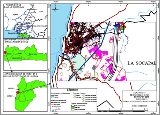
Figure 1: Location plan of the study area (TALLA).
3.2 Developed features.
Thanks to the collection of needs expressed by stakeholders, the identified functionalities that the GIS should offer to enable effective management of MINDCAF's land assets are summarized in Table 1
Table 1: GIS functionalities.
FUNCTIONALITY |
Management of cadastral data and land ownership information |
Cartographic visualization of plots and property boundaries. |
Spatial analysis for the identification of risk areas, the evaluation of real estate values, etc. |
Monitoring of land transactions and changes in ownership. |
Management of land use rights and easements. |
Integration with other information systems (e.g. cadastral database, information system national geographic). |
Spatial analysis for the identification of risk areas, the evaluation of |
Generation of reports and documents linked to land ownership. |
Monitoring of land transactions. |
Collaboration between the different actors involved in land management (e.g. administrations public authorities, notaries, surveyors). |
Monitoring and management of land disputes. |
Integration of external data such as urban plans or environmental data for informed decision-making. |
Tableau 1: Fonctionnalités du SIG.
FONCTIONNALITE |
Gestion des données cadastrales et des informations sur la propriété foncière |
Visualisation cartographique des parcelles et des limites de propriété. |
Analyse spatiale pour l'identification des zones à risque, l'évaluation des valeurs immobilières, etc. |
Suivi des transactions foncières et des changements de propriété. |
Gestion des droits d'utilisation du sol et des servitudes. |
Intégration avec d'autres systèmes d'information (ex: base de données cadastrales, système d'information géographique national). |
Génération de rapports et de documents liés à la propriété foncière. |
3.3 Data acquired and processed.
All data from different methods have been harmonized and grouped under different layers. Ultimately, the database brings together more than
1000 geographical entities on the
The map and web GIS is an application that allows you to manage, visualize and query spatial and attribute data relating to Talla's land heritage. The Interface is reserved for MINDCAF agents and other stakeholders and allows you to consult general information on land assets such as the location of the plots, the surface area, the number of plots available, information on the
Land heritage of Talla with their detailed attributes. Figure 2 shows the collection of all data in a single ArcGIS project.
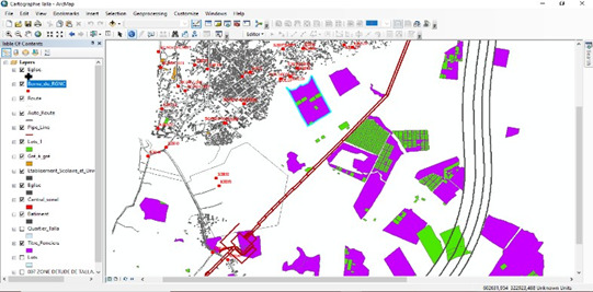
Figure 2: Spatial data acquired, processed and home page of our GIS Cartography.
The map and web GIS is an application that allows you to manage, visualize and query spatial and attribute data relating to Talla's land heritage. The Interface is reserved for MINDCAF agents and other stakeholders and allows you to consult general information on land assets such as the location of the plots, the surface area, the number of plots available, information on the property of the TF, etc. It also offers the possibility of searching for a plot of land according to geographical or thematic criteria, and of viewing the results in the form of a map or list. It also makes it possible to carry out.

Figure 2: localization plan of the study zone
3.4.0 Developed features. Thanks to the collection of needs expressed by stakeholders, the identified functionalities that the GIS should offer to enable effective management of MINDCAF's land assets are summarized in Table 1.
Table 1: GIS functionalities.
FONCTIONNALITE |
Management of cadastral data and land ownership information |
Cartographic visualization of plots and property boundaries.. |
Spatial analysis for the identification of risk areas, the evaluation of real estate values, etc. |
Monitoring of land transactions and changes in ownership. |
Management of land use rights and easements. |
Integration with other information systems (e.g. cadastral database, information system national geographic). |
Generation of reports and documents linked to land ownership. |
Collaboration between the different actors involved in land management (e.g. administrations public authorities, notaries, surveyors). |
Monitoring and management of land disputes. |
Integration of external data such as urban plans or environmental data for informed decision-making. |
3.4.1 Data acquired and processed. All data from different methods have been harmonized and grouped under different layers. Ultimately, the database brings together more than 1000 geographical entities on the

Figure 2: Spatial data acquired, processed and home page of our GISCartography.
3.4.2 Presentation of SIGCartographic and GISWEB
3.4.3 Data acquired and processed. All data from different methods have been harmonized and grouped under different layers. Ultimately, the database brings together more than 1000 geographical entities on the map and web GIS is an application that allows you to manage, visualize and query spatial and attribute data relating to Talla's land heritage. The Interface is reserved for MINDCAF agents and other stakeholders and allows you to consult general information on land assets such as the location of the plots, the surface area, the number of plots available, information on the land heritage of Talla with their detailed attributes. Figure 2 shows the collection of all data in a single ArcGIS project.
Property of the TF, etc. It also offers the possibility of searching for a plot of land according to geographical or thematic criteria, and of viewing the results in the form of a map or list. It also makes it possible to carry out spatial analyses, in order to evaluate trends, identify needs and opportunities and plan the actions to be taken. Finally, it allows you to generate reports and dashboards to facilitate the monitoring and control of land assets.
The map and web GIS is an application that allows you to manage, visualize and query spatial and attribute data relating to Talla's land heritage. The Interface is reserved for MINDCAF agents and other stakeholders and allows you to consult general information on land assets such as the location of the plots, the surface area, the number of plots available, information on the
Land heritage of Talla with their detailed attributes. Figure 2 shows the collection of all data in a single ArcGIS project.
The user is redirected to the home page which presents all the GIS functionalities at a glance. The figure 3 presents the GIs Cartography home page and figure 6 presents the opening of Google Earth, which allows users to visualize and analyze the land heritage of the ocean. It offers a range of features such as searching with filters, natural language queries, data visualization on an interactive map, dynamic table of general information, dynamic visuals and charts. the opening of Google Earth, which allows users to visualize and analyze the land heritage of the ocean. It offers a range of features such as searching with filters, natural language queries, data visualization on an interactive map, dynamic table of general information, dynamic visuals and charts.
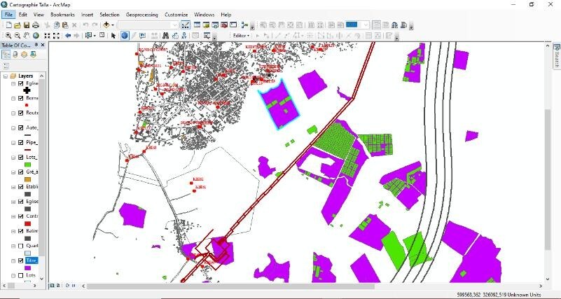
Figure 3: The SIGCartography home page.
The implementation of our GIS will make it easier for us to carry out searches just by typing a keyword such as the number of a land title.
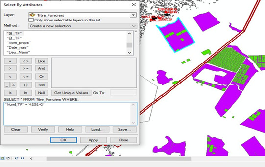
Figure 4: SQL query to facilitate the search for an element in our GIS.
With the geographic identification tool, we can click on our geographic entity and display information relating to the ownership of this plot as mentioned in the land book.
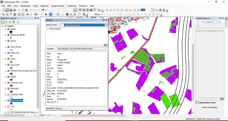
Figure 5: Navigation and taking information on a T.F.
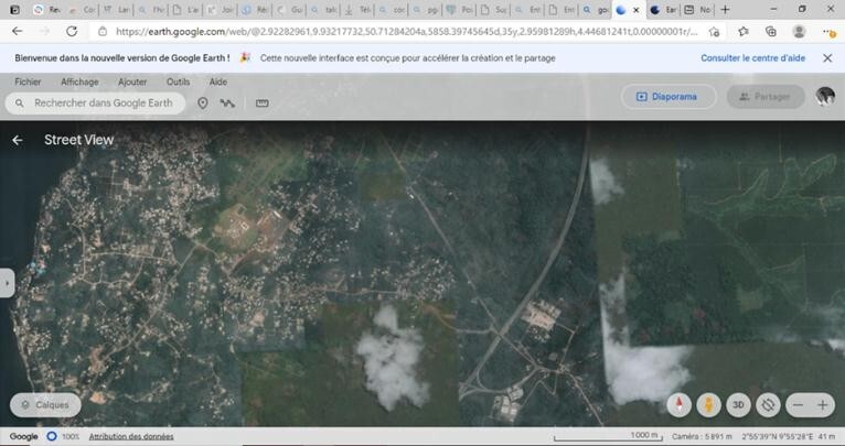
Figure 6: Opening Google Earth.
The online distribution of data relating to land ownership was an option for us to explore because it helps promote transparency, improve access to information, facilitate real estate transactions and strengthen land governance. With this option, it is easier for players to view free spaces and make a purchase in complete security.
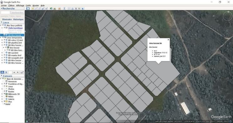
Figure 7: Consultation of plots via the Google Earth platform.
3.4.4 Discussion and recommendations. Given the limits of current management of land assets at MINDCAF, particularly in terms of rapid accessibility of information, efficiency in the archiving of files, and data, the GIS developed in the TALLA study area is a solution that meets the needs expressed by the different stakeholders involved in the management of land assets.
This solution more specifically presents advantages which have made it possible to improve the management and monitoring of real estate by centralizing and rationalizing information relating to land data, helping with decision-making and planning by facilitating analysis and visualization. geographical data, optimize the management of land assets by making it possible to carry out spatial analyzes of data and detection of anomalies which will optimize the management of land assets, putting data online enhance land assets in the eyes of investors and partners by facilitating access to information on the areas concerned and modernize the image of MINDCAF by demonstrating technological innovation and data transparency. Although GIS offers many advantages for land asset management, its use poses some challenges. These include collecting all land information and updating it, managing data privacy and security, integrating different data sources, standardizing data from different jurisdictions, and training staff in the use of GIS.
Furthermore, avenues for improving GIS for better management of land assets include:
Improving data quality: Establishing quality control mechanisms for land data, by encouraging regular updating, verification and validation of information;
Strengthen data collection: Establish partnerships with relevant institutions, such as cadastral services, to facilitate the collection and sharing of land data;
Invest in training: Providing continuing education to professionals working with GIS, in order to strengthen their technical skills and understanding of issues related to land management;
Promote interoperability: Develop standards and protocols for exchanging geospatial data to ensure interoperability between different systems and facilitate the integration of land information;
Raise awareness and engage stakeholders: Organize workshops, seminars and awareness campaigns to inform landowners, policymakers and the general public about the importance of effective land data management.
For example, the sectoral held at KRIBI on September 23, 2023 on land management; Encourage collaboration: Foster collaboration between different entities involved in land management, including local administrations, government agencies, development organizations and community organizations; Promote open access to data: Encourage the free and open provision of land data, while respecting confidentiality and security, in order to promote transparency and citizen participation.
4 Conclusion
The objective of this study was to establish a GIS in the Ocean department in order to facilitate access to land information for its management. In the specific case of the MINDCAF of the ocean, it has been demonstrated that manual management in terms of the conservation of its land assets leads to problems such as slowness in the provision of information, complexity in the organization storage, financial losses, loss of documents, land conflicts and unreliable access to land information. The establishment of a GIS dedicated to the management of land assets was proposed as a solution to remedy these problems. The results obtained following the implementation of GIS in the Talla zone demonstrated its effectiveness and relevance for land asset management. The functionalities of our cartography space (interactive cartography, spatial and alphanumeric navigation, multi-criteria and spatial analysis, editing, attribute queries and reporting) were presented as well as the data acquired and the data models designed. However, challenges such as training users in new tools and the constant evolution of technologies have been identified and require significant efforts to ensure the data reliability, facilitate user adaptation and keep the system up to date. Furthermore, improvements can be considered such as developing tools to automate digitization processes, setting up a real-time web portal for better management of information extracted from the MINDCAF database and making it accessible to the general public, carry out a digitization of all the plans still stored in the archives service, and carry out the connection of the information obtained to the Cameroonian National Geodetic Network (RGNC) for their superposition with other current data layers. At the end of this work, a question remains: is it prudent to completely abandon the physical archiving system in favor of a digital archiving system?
References
[1]. Jean Denègre, François Salgé, Geographic information systems, PUF, Paris, France, 2004.
[2]. PAUTHONNIER Alexandre, GIS and information and communication technologies, Paris, France, 2010.
[3]. El Mostapha ELFATIHI, El Hassane, Implementation of a S.I.G. multi-use for the management of cadastral and urban data and its deployment on the Internet (Case of the municipality of Anfa).
[4]. Brand KAMGA, the land war, Investigation show on Naya TV. In 2022
[5]. Ambang Martin, Land title, Right to clarity, CRTV, Yaoundé, May 8, 2014.
[6]. JG ELONG, AND FM Obam, Land tensions between exogenous actors and local communities in the forest massif of eastern Kribi.
[7]. African Development Bank, Cadastre: The impact of the AfDB on land reform
[8]. Africa Renewal: AfDB, AU Commission and ECA commit to financing land governance in Africa December 2021 - November 11
[9]. OBSERVATORY OF LAND ACQUISITION A LARGE SCALE IN CAMEROON BY THE PAUL ANGO ELA FOUNDATION(FPAE). Written by Olivier IYEBI MANDJEK (FPAE), Philippe KARPE (CIRAD/FPAE) and Stéphane Akoa (FPAE).
[10]. “Report on the progress and effects of cholera in Paris and the Seine department. Year 1832 » [archive], Gallica (accessed May 10, 2012).
Cite this article
Anicet,B.G.;Kevine,M.P.Y.;MUNONGO,M.E. (2023). Implementation of a GIS for management effectiveness of data relating to land property, in the department of the ocean (Kribi location). Advances in Engineering Innovation,4,52-61.
Data availability
The datasets used and/or analyzed during the current study will be available from the authors upon reasonable request.
Disclaimer/Publisher's Note
The statements, opinions and data contained in all publications are solely those of the individual author(s) and contributor(s) and not of EWA Publishing and/or the editor(s). EWA Publishing and/or the editor(s) disclaim responsibility for any injury to people or property resulting from any ideas, methods, instructions or products referred to in the content.
About volume
Journal:Advances in Engineering Innovation
© 2024 by the author(s). Licensee EWA Publishing, Oxford, UK. This article is an open access article distributed under the terms and
conditions of the Creative Commons Attribution (CC BY) license. Authors who
publish this series agree to the following terms:
1. Authors retain copyright and grant the series right of first publication with the work simultaneously licensed under a Creative Commons
Attribution License that allows others to share the work with an acknowledgment of the work's authorship and initial publication in this
series.
2. Authors are able to enter into separate, additional contractual arrangements for the non-exclusive distribution of the series's published
version of the work (e.g., post it to an institutional repository or publish it in a book), with an acknowledgment of its initial
publication in this series.
3. Authors are permitted and encouraged to post their work online (e.g., in institutional repositories or on their website) prior to and
during the submission process, as it can lead to productive exchanges, as well as earlier and greater citation of published work (See
Open access policy for details).
References
[1]. Jean Denègre, François Salgé, Geographic information systems, PUF, Paris, France, 2004.
[2]. PAUTHONNIER Alexandre, GIS and information and communication technologies, Paris, France, 2010.
[3]. El Mostapha ELFATIHI, El Hassane, Implementation of a S.I.G. multi-use for the management of cadastral and urban data and its deployment on the Internet (Case of the municipality of Anfa).
[4]. Brand KAMGA, the land war, Investigation show on Naya TV. In 2022
[5]. Ambang Martin, Land title, Right to clarity, CRTV, Yaoundé, May 8, 2014.
[6]. JG ELONG, AND FM Obam, Land tensions between exogenous actors and local communities in the forest massif of eastern Kribi.
[7]. African Development Bank, Cadastre: The impact of the AfDB on land reform
[8]. Africa Renewal: AfDB, AU Commission and ECA commit to financing land governance in Africa December 2021 - November 11
[9]. OBSERVATORY OF LAND ACQUISITION A LARGE SCALE IN CAMEROON BY THE PAUL ANGO ELA FOUNDATION(FPAE). Written by Olivier IYEBI MANDJEK (FPAE), Philippe KARPE (CIRAD/FPAE) and Stéphane Akoa (FPAE).
[10]. “Report on the progress and effects of cholera in Paris and the Seine department. Year 1832 » [archive], Gallica (accessed May 10, 2012).