


1. Introduction
River is an intermediate link connecting the process of tectonic uplift and surface erosion in the orogenic zone, and it is an important geomorphic unit to record the information of external driving forces such as tectonic activities and climate change [1-4]. In recent years, many tectonic geomorphology scholars have devoted themselves to extracting past structural information at different time scales from the longitudinal profiles of river channels in orogenic belts [5-7]. However, in the alpine canyon area, landslides dominate the erosion process of the hillslope, and large landslides often fill the valley, forming a barrier dam, causing channel siltation upstream, thus changing the shape of the river longitudinal profile [8]. Landslide dam affects the landscape process of mountainous areas by affecting the river longitudinal profile. Most of the existing river barrier related studies focus on the high mountains and valleys around the Qinghai-Tibet Plateau, for example, analyze its persistent effects on river sedimentation and erosion in southeast Tibet, Karakoram mountains and other areas [9-11], and the stability of the landslide dam and its geomorphic environmental effects [12]. Previous studies have discussed the effects of multiple dams on the comprehensive effect of the longitudinal profile of trunk rivers from the perspective of large watershed scale, such as the eastern and western margin [13], and there is no systematic research on the response of medium scale watershed to damming events.
The topographic rapid change belt on the eastern edge of the Qinghai-Tibet Plateau has the landscape, structure and climatic conditions of the landslide barrier lake, and is also a potential area for frequent high-energy outburst floods [14]. The Jinsha River pass through the Hengduan mountain area with high valley depth, the geological structure is active, and the river drop is large, leading to the frequent damminging events, which has a huge effect and influence on the evolution of the valley landscape, and makes the study of the landscape evolution of the Jinsha River more complicated. Many scholars, through field trips and indoor analysis, to identify the residual dam and the scale of dam, the identification of dammed lake sediment, sediment dating and other indicators [15-17], Combined with the regional tectonic activities to reconstruct the river damming event in the geological period, explore its effect and influence on the landscape evolution of Jinsha River Valley [18-19].
This paper mainly obtains the spatial distribution of the landslide dam, using the TopoToolbox to extract the river knickpoint, steepness index and excess topography, systematically analyzes the effect of landslide on channel and hillslope, and provides new ideas for the study of landscape evolution in this region.
2. Study Area
The Jinsha River is located on the eastern edge of the Qinghai-Tibet Plateau, which is belong high elevation, low-relief landscape [20]. The Jinsha River is 3481 km long from the source of Yushu, Qinghai province to Yibing, Sichuan province, covering a basin area of 502000 km2, It is located in the upstream of the Yangtze River. The Jinsha River has an elevation difference of 3300 m and have a rich water resource, accounting for more than 40% of the water resources in the Yangtze River. The Jinsha river flows through the high mountain and deeply valley, and it is within the range of the secondary fault, three river parallel fault and Jinsha River fault in the northern region of Gutetes, such as active fault block extrusion, differential lifting and fracture sliding activities lead to frequent river damming events.
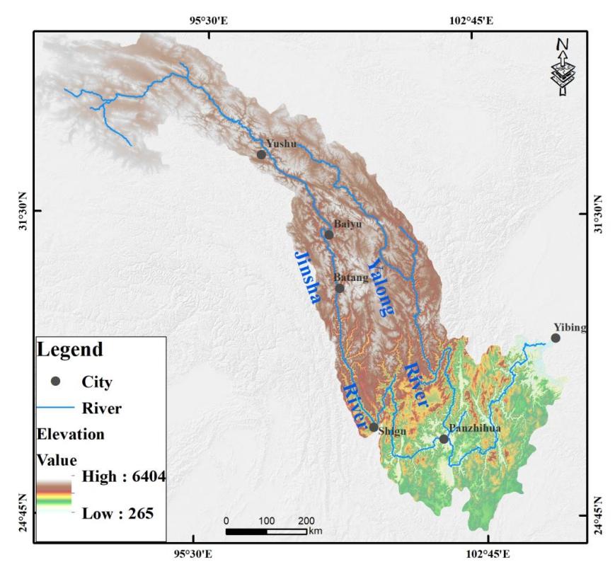
Figure 1. Overview of the study area in the Jinsha River
3. Methods
3.1. Remote Sensing Interpretation of landslide dams
Landslide is generally interpreted by three more recognizable elements: landslide accumulation, landslide back wall and landslide boundary. The visual interpretation of landslide is mainly performed by identifying the shape, size, color, shadow, texture and other characteristics of the remote sensing images of landslide [21]. The remote sensing images show the color and vegetation development different from the surrounding environment. There are obvious landslide remains in the river, and the river width will narrow due to the barrier event; there will be closed depressions between the landslide and the rear wall, and the above are interpretation marks of landslide interpretation. Second, we verified and modified the partially translated landslides through field investigation (Figure 2). In addition, this paper also draws the general boundary of the landslide, estimates the area of the landslide, and then using volume‐area scaling relationship to estimate landslide volume [22],
\( V=α{A^{γ}} \ \ \ (1) \)
Where V represents the landslide volume (m3), A represents the landslide area(m2), and α and γ are power-law scaling parameters, in this study , we use the α=0.23 and γ=1.41 to calculate landslide volume[18].
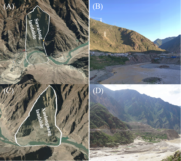
Figure 2. Remote sensing interpretation of landslide dams
3.2. Digital Terrain Analysis
The SRTM DEM data at the 30m spatial resolution used in this paper are all obtained from the US Geological Survey United States Geological Survey (USGS) data sharing platform (https://earthexplorer.usgs.gov/). In this paper, the TopoToolbox was used to extract the river geomorphic parameters [23-24], and the TopoToolbox to extract the DEM containing projection information as the input data (https:// topotoolbox.wordpress.com/). Considering the geographical location of the transection area, the projection coordinate system used in this study is WGS_1984_UTM_zone_47 N.
3.2.1. Excess Topography Extraction. Excess topography refers to a potentially unstable hillslope with a slope greater than the threshold hillslope. Assuming that the threshold hillslope always exists, the excess topography can be used to represent all the large bedrock landslides within the region. The site-specific threshold hillslope surface extraction excess topography process is performed as follows [25],
\( \dot{z}(x,y)=\underset{(s,t)∈(-∞,∞)}{min}{\lbrace z(x+s,y+t)+{s_{t}}\sqrt[]{{s^{2}}+{t^{2}}}\rbrace }\ \ \ (2) \)
where z represents the real elevation of the topography, \( x,y \) represents coordinates, and \( s,t \) represents the filter coefficient, which refers to the distance from the center of the filter to the point \( (x,y) \) .
The elevation of excess topography zE can be extracted by subtracting the elevation of the threshold hillslope surface from the real surface elevation as follows:
\( {z_{E}}(x,y)=z(x,y)-\dot{z}(x,y) \ \ \ (3) \)
3.2.2. Steepness Index Extraction. To obtain the effect of the landslide dam on the river longitudinal profile in the Jinsha River, we used the Stream-Power River Incision Model, it can be quantified by relationship between upstream catchment area and channel gradient [3]:
\( S={k_{s}}{A^{-θ}} \ \ \ (4) \)
where S is channel slope, °; ks is the steepness index, m0.9; A is the upstream catchment area, m2; in
This study we fixed concavity index of θ = 0.45 to extract the normalized steepness index (ksn) to facilitate the comparison of the differences between of more reaches[26].
3.2.3. River Knickpoint Extraction. The river knickpoint refers to the position where the channel gradient changes significantly and the river longitudinal profile appears obviously convex [27]. In this study, the improved longitudinal profile elevation steep descent method was used to extract river knickpoint. Then we used the knickpoint finder function in TopoToolbox to automatically extract the smooth river longitudinal profile from the 30m STRM DEM to reduce the artificial subjective error [23]. Knickpoint Finder adjusts the strictly concave upward profile to the actual profile until offsets fall below a specified tolerance value (Figure 3) [24]. In this paper, the tolerance value was set to 30m to extract the knickpoint in the Jinsha River, and knickpoint height was used to directly quantify of knickpoint magnitude.
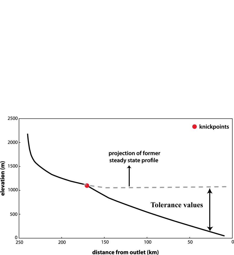
Figure 3. Schematic diagram of the knickpoint tolerance values
4. Result
4.1. Relationship between landslide dam and excess topography
Through remote sensing interpretation and field investigation, we found a total of 660 landslide dams in the Jinsha River (Figure 4), and we obtained the landslide volume by using empirical formulas. We divided the landslide into four types according to the volume of the landslide (Table 1), respectively small, medium, large, giant. 12 small landslides, mainly distributed in the upper reaches of the plateau surface of the Jinsha River. 37 medium landslides, mainly distributed in the small tributaries of the Jinsha River.111 large landslides, mainly distributed in big tributaries of the Jinsha River, and 500 giant landslide, mainly in the upper and middle reaches of the Jinsha River, it indicates that blocking river are require large or giant volume landslide. Among the 660 landslides, 626 landslides are located in the excess topography with a threshold hillslope of 30°, more than 90%, indicating that landslide is one of the important manifestations of hillslope erosion, and also one of the most common and efficient hillslope erosion events.
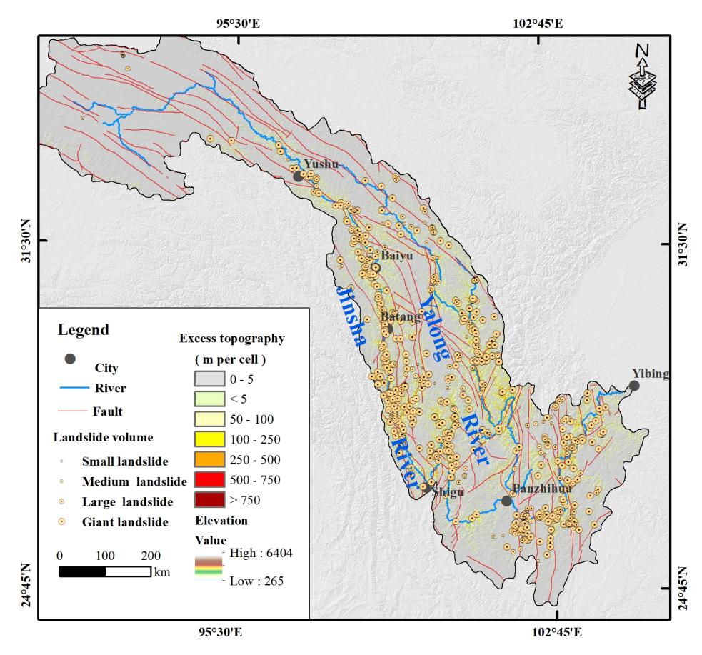
Figure 4. Distribution map of landslide and excess topography
Table 1. Classification of landslide types
Landslide type | Landslide volume(m3) | Number | Percent |
Small landslide | < 10×104 | 12 | 2% |
Medium landslide | 10×104 - 100×104 | 37 | 5% |
Large landslide | 100×104 - 1000×105 | 111 | 17% |
Giant landslide | > 1000×104 | 500 | 76% |
4.2. Distribution of river knickpoint and ksn
We extracted a total of 418 river knickpoint in the Jinsha River, It is mainly concentrated in the tributaries of the and middle and downstream reaches (Figure5). We made preliminary statistics of the height and elevation distribution of the knickpoints (Table 2). Among the 418 knickpoint, 271 knickpoints between the 30 m to 50 m in height difference distributed in the middle reach of the Jinsha river. 141 knickpoints between the 50 m to 100 m in height difference distributed in the small tributaries. 31 knickpoints between the 100 m to 150 m in height difference distributed near the big tributaries. 22 knickpoints between the 150 m to 250 m in height difference distributed near the upstream of tributary valley. 16 knickpoints are above 250 m in height difference distributed near the fault line. Through the comparison of spatial relations, it is found that in these 481 river knickpoints, there are 70 knickpoints overlapping with the landslide dam space, among which the maximum knickpoint height can reach 478m(Figure 6).
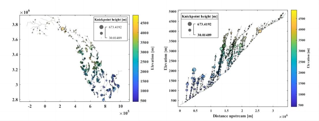
Figure 5. Distribution of river knickpoints in the Jinsha River.
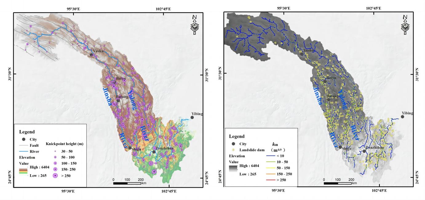
Figure 6. Relationship between landslide dam, faults, ksn in the Jinsha River.
Table 2. Distribution characteristics of knickpoints in the Jinsha River.
Knickpoint height (m) | Number | Knickpoint elevation (m) | Number |
30-50 | 271 | <1000 | 81 |
50-100 | 141 | 1000-2000 | 132 |
100-150 | 31 | 2000-3000 | 152 |
150-250 | 22 | 3000-4000 | 130 |
>250 | 16 | >4000 | 40 |
5. Discussion
From the perspective of the long-term evolution process of landscape, river erosion and hillslope erosion are coupled in the development process of river evolution. The river continues to erode the hillslope, leading to the steeper foot. When the slope reaches a certain steep degree, the slope becomes unstable, and the earthquake and heavy rainfall events will quickly adjust to the original balance in the form of landslide [25]. The occurrence of landslide is the instantaneous response of the slope process to the erosion of rivers. The rapidly moving landslide can accumulate in the narrow channels within minutes or even seconds to form a barrier dam . Through DEM, we extracted the river longitudinal profile and ksn, and superimposed the landslide dam with the them (Figure 7). We found that the landslide dam has can effect river landscape elevation. In the densely distributed river channel of the landslide dam, the ksn with the relatively high values, and the corresponding river longitudinal profile is steeper in the Jinsha River. Fan et al. (2020) [28] extracted 666 knickpoint in the Min River basin, and found that most of the knickpoint were related to the debris or landslides.
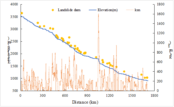
Figure 7. The spatial relationship between the landslide dam and ksn in the Jinsha River
6. Conclusion
By using TopoToolbox, we extracted the longitudinal profile, knickpoints and ksn values of the Jinsha River basin, and compared them with the field survey and remote sensing interpretation. There are 481 knickpoints and 660 landslide dams were identified, more than 90% landslides dams are located in the excess topography with a threshold hillslope of 30°. Our analysis reveals that the locations of 70 landslide dams and river knickpoints with heights above 30 m are spatially consistent. Among these landslide dams, the influence of 6 landslide dams on the channel can reach more than 100m, they can have knickpoint maximum height of over 478 m. Overall, By comparing the relationship between the landslide dam, ksn, excess topography and knickpoint, They were found to have a good spatial correlation in the Jinsha River, it can indicate landslide dams play an important role in the landscape evolution with hillslope and channel.
Funding
This work was financially supported by the by the Second Tibetan Plateau Scientific Expedition and Research Program (STEP, Grant Nos. 2019QZKK0903, STEP, Grant Nos. 2019QZKK0906 )
References
[1]. Whipple K X. (2004). Bedrock rivers and the geomorphology of active orogens. Annual Review of Earth and Planetary Sciences, 32: 151-185.
[2]. Zhao, X., Zhang, H., Hetzel, R., Kirby, E., Duvall, A. R., Whipple, K. X., ... & Zhang, P. (2021). Existence of a continental-scale river system in eastern Tibet during the late Cretaceous–early Palaeogene. Nature communications, 12(1): 7231.
[3]. Kirby E., Whipple K X. (2001). Quantifying differential rock-uplift rates via stream profile analysis. Geology, 29(5): 415-418.
[4]. Kirby E., Whipple K X. (2012). Expression of active tectonics in erosional landscapes. Journal of Structural Geology, 44: 54-75.
[5]. Scheingross, J.S., Limaye, A.B., McCoy, S.W., Whittaker, A.C. 2020. The shaping of erosional landscapes by internal dynamics. Nat Rev Earth Environ, 1, 661–676.
[6]. Willett, S.D., McCoy, S.W., Perron, J.T., Goren, L., Chen, C.-Y. 2014. Dynamic Reorganization of River Basins. Science, 343(6175), 1248765.
[7]. Zhao, X., Zhang, H., Lease, R. O., Wang, Y., Pang, J., Li, Y., & Zhang, P. (2023). Early Cenozoic drainage evolution and surface uplift of the eastern Tibetan Plateau: Insights from the Ninglang Basin. Geophysical Research Letters, 50(19), e2023GL105499.
[8]. Korup O., Densmore A L., Schluneger F. (2010). The role of landslides in mountain range evolution[J]. Geomorphology, 120(1/2): 77-90.
[9]. Wang, H., Cui, P., Liu, D., Liu, W., Bazai, N. A., Wang, J., ... & Lei, Y. (2019). Evolution of a landslide-dammed lake on the southeastern Tibetan Plateau and its influence on river longitudinal profiles. Geomorphology, 343: 15-32.
[10]. Hewitt, K. (2006). Disturbance regime landscapes: mountain drainage systems interrupted by large rockslides. Progress in Physical Geography, 30: 365–393.
[11]. Ouimet, W.B., Whipple, K.X., Royden, L.H., Sun, Z., Chen, Z. (2007). The influence of large landslides on river incision in a transient landscape: Eastern margin of the Tibetan Plateau (Sichuan, China). Geol. Soc. Am. Bull, 119: 1462-1476.
[12]. Li, Y., Chen, J., Yan, J., Zhou, F., Wang, Q., Li, Z., & Zhang, Y. (2022). Formation and evolution of a giant old deposit in the First Bend of the Yangtze River on the southeastern margin of the Qinghai-Tibet Plateau. Catena, 213, 106138.
[13]. Korup O., Montgomery D R., Hewitt K. (2010). Glacier and landslide feedbacks to topographic relief in the Himalayan syntaxes. Proceedings of the National Academy of Sciences of the United States of America, 107(12): 5317-5322.
[14]. Liu, W., Carling, P. A., Hu, K., Wang, H., Zhou, Z., Zhou, L., Liu, D., Lai, Z., and Zhang, X. (2019). Outburst floods in China: A review. Earth-Science Reviews 197, 102895
[15]. Zhang, Y., Chen, J., Zhou, F., Bao, Y., Yan, J., Zhang, Y., & Wang, Q. (2022). Combined numerical investigation of the Gangda paleolandslide runout and associated dam breach flood propagation in the upper Jinsha River, SE Tibetan Plateau. Landslides, 2022, 19(4): 941-962.
[16]. Xu, H., Chen, J., Chen, R., Cui, Z., Mi, D., & Shi, L. (2023). Evolution process of the Yinduba paleolandslide-dammed lake in the upper **sha River, SE Tibetan Plateau. Frontiers in Earth Science, 11, 1144992.
[17]. Bao, Y., Zhai, S., Chen, J., Xu, P., Sun, X., Zhan, J., & Zhou, X. (2020). The evolution of the Samaoding paleolandslide river blocking event at the upstream reaches of the Jinsha River, Tibetan Plateau. Geomorphology, 351, 106970.
[18]. Liu, W., Hu, K., Carling, P.A., Lai, Z., Cheng, T., & Xu, Y. (2018). The establishment and influence of Baimakou paleo-dam in an upstream reach of the Yangtze River, southeastern margin of the Tibetan Plateau. Geomorphology 321: 167-173.
[19]. Wang, H., Tong, K., Hu, G., Wang, P., & Chen, J. (2020). Dam and megafloods at the First Bend of the Yangtze River since the Last Glacial Maximum. Geomorphology 373, 107491.
[20]. Ding, Y., Zhang, X., He, Z., Lu, C., & Bao, S. (2021). Sedimentary environment of a dammed lake buried in the modern riverbed of the Yalong River during the Last Glacial Maximum and its implication for fluvial geomorphic evolution. Geomorphology, 378, 107588.
[21]. Zhou, L., Liu, W., Chen, X., Wang, H., Hu, X., Li, X., & Schwanghart, W. (2021). Relationship between dams, knickpoints and the longitudinal profile of the Upper Indus River. Frontiers in Earth Science, 9, 660996.
[22]. Larsen, I.J., Montgomery, D.R., Korup, O. (2010). Landslide erosion controlled by hillslope material. Nature Geosci. 3: 247-251.
[23]. Schwanghart, W., and Scherler, D. (2014). Short Communication: TopoToolbox 2 - MATLAB-Based Software for Topographic Analysis and Modeling in Earth Surface Sciences. Earth Surf. Dynam. 2 (1): 1 –7.
[24]. Schwanghart, W., and Scherler, D. (2017). Bumps in River Profiles: Uncertainty Assessment and Smoothing Using Quantile Regression Techniques. Earth Surf. Dynam. 5 (4): 821–839.
[25]. Blöthe J, Korup O, Schwanghart W. (2025). Large landslides lie low: Excess topography in the Himalaya-Karakoram ranges. Geology, 43(6): 523-526.
[26]. Hu, X. D., Zhou, L. Q., Liu, W. M., Wang, H., & Cui, L. (2021). Geomorphic effect of debris-flow sediments on the Min River, Wenchuan Earthquake region, western China. Journal of Mountain Science, 18(9): 2427-2440.
[27]. Gailleton, B., Mudd, S. M., Clubb, F. J., Peifer, D., and Hurst., M. D. (2019). A Segmentation Approach for the Reproducible Extraction and Quantification of Knickpoints from River Long Profiles. Earth Surf. Dynam. 7: 211–230.
[28]. Fan, X., Yunus, A. P., Jansen, J. D., Dai, L., Strom, A., & Xu, Q. (2022). Comment on ‘Gigantic rockslides induced by fluvial incision in the Diexi area along the eastern margin of the Tibetan Plateau’by Zhao et al. (2019) Geomorphology 338, 27–42. Geomorphology, 402: 106963.
Cite this article
Zhou,L.;Liu,W.;Zhou,Y. (2024). Geomorphic effect of landslide dam on the Jinsha River. Applied and Computational Engineering,66,178-186.
Data availability
The datasets used and/or analyzed during the current study will be available from the authors upon reasonable request.
Disclaimer/Publisher's Note
The statements, opinions and data contained in all publications are solely those of the individual author(s) and contributor(s) and not of EWA Publishing and/or the editor(s). EWA Publishing and/or the editor(s) disclaim responsibility for any injury to people or property resulting from any ideas, methods, instructions or products referred to in the content.
About volume
Volume title: Proceedings of the 2nd International Conference on Functional Materials and Civil Engineering
© 2024 by the author(s). Licensee EWA Publishing, Oxford, UK. This article is an open access article distributed under the terms and
conditions of the Creative Commons Attribution (CC BY) license. Authors who
publish this series agree to the following terms:
1. Authors retain copyright and grant the series right of first publication with the work simultaneously licensed under a Creative Commons
Attribution License that allows others to share the work with an acknowledgment of the work's authorship and initial publication in this
series.
2. Authors are able to enter into separate, additional contractual arrangements for the non-exclusive distribution of the series's published
version of the work (e.g., post it to an institutional repository or publish it in a book), with an acknowledgment of its initial
publication in this series.
3. Authors are permitted and encouraged to post their work online (e.g., in institutional repositories or on their website) prior to and
during the submission process, as it can lead to productive exchanges, as well as earlier and greater citation of published work (See
Open access policy for details).
References
[1]. Whipple K X. (2004). Bedrock rivers and the geomorphology of active orogens. Annual Review of Earth and Planetary Sciences, 32: 151-185.
[2]. Zhao, X., Zhang, H., Hetzel, R., Kirby, E., Duvall, A. R., Whipple, K. X., ... & Zhang, P. (2021). Existence of a continental-scale river system in eastern Tibet during the late Cretaceous–early Palaeogene. Nature communications, 12(1): 7231.
[3]. Kirby E., Whipple K X. (2001). Quantifying differential rock-uplift rates via stream profile analysis. Geology, 29(5): 415-418.
[4]. Kirby E., Whipple K X. (2012). Expression of active tectonics in erosional landscapes. Journal of Structural Geology, 44: 54-75.
[5]. Scheingross, J.S., Limaye, A.B., McCoy, S.W., Whittaker, A.C. 2020. The shaping of erosional landscapes by internal dynamics. Nat Rev Earth Environ, 1, 661–676.
[6]. Willett, S.D., McCoy, S.W., Perron, J.T., Goren, L., Chen, C.-Y. 2014. Dynamic Reorganization of River Basins. Science, 343(6175), 1248765.
[7]. Zhao, X., Zhang, H., Lease, R. O., Wang, Y., Pang, J., Li, Y., & Zhang, P. (2023). Early Cenozoic drainage evolution and surface uplift of the eastern Tibetan Plateau: Insights from the Ninglang Basin. Geophysical Research Letters, 50(19), e2023GL105499.
[8]. Korup O., Densmore A L., Schluneger F. (2010). The role of landslides in mountain range evolution[J]. Geomorphology, 120(1/2): 77-90.
[9]. Wang, H., Cui, P., Liu, D., Liu, W., Bazai, N. A., Wang, J., ... & Lei, Y. (2019). Evolution of a landslide-dammed lake on the southeastern Tibetan Plateau and its influence on river longitudinal profiles. Geomorphology, 343: 15-32.
[10]. Hewitt, K. (2006). Disturbance regime landscapes: mountain drainage systems interrupted by large rockslides. Progress in Physical Geography, 30: 365–393.
[11]. Ouimet, W.B., Whipple, K.X., Royden, L.H., Sun, Z., Chen, Z. (2007). The influence of large landslides on river incision in a transient landscape: Eastern margin of the Tibetan Plateau (Sichuan, China). Geol. Soc. Am. Bull, 119: 1462-1476.
[12]. Li, Y., Chen, J., Yan, J., Zhou, F., Wang, Q., Li, Z., & Zhang, Y. (2022). Formation and evolution of a giant old deposit in the First Bend of the Yangtze River on the southeastern margin of the Qinghai-Tibet Plateau. Catena, 213, 106138.
[13]. Korup O., Montgomery D R., Hewitt K. (2010). Glacier and landslide feedbacks to topographic relief in the Himalayan syntaxes. Proceedings of the National Academy of Sciences of the United States of America, 107(12): 5317-5322.
[14]. Liu, W., Carling, P. A., Hu, K., Wang, H., Zhou, Z., Zhou, L., Liu, D., Lai, Z., and Zhang, X. (2019). Outburst floods in China: A review. Earth-Science Reviews 197, 102895
[15]. Zhang, Y., Chen, J., Zhou, F., Bao, Y., Yan, J., Zhang, Y., & Wang, Q. (2022). Combined numerical investigation of the Gangda paleolandslide runout and associated dam breach flood propagation in the upper Jinsha River, SE Tibetan Plateau. Landslides, 2022, 19(4): 941-962.
[16]. Xu, H., Chen, J., Chen, R., Cui, Z., Mi, D., & Shi, L. (2023). Evolution process of the Yinduba paleolandslide-dammed lake in the upper **sha River, SE Tibetan Plateau. Frontiers in Earth Science, 11, 1144992.
[17]. Bao, Y., Zhai, S., Chen, J., Xu, P., Sun, X., Zhan, J., & Zhou, X. (2020). The evolution of the Samaoding paleolandslide river blocking event at the upstream reaches of the Jinsha River, Tibetan Plateau. Geomorphology, 351, 106970.
[18]. Liu, W., Hu, K., Carling, P.A., Lai, Z., Cheng, T., & Xu, Y. (2018). The establishment and influence of Baimakou paleo-dam in an upstream reach of the Yangtze River, southeastern margin of the Tibetan Plateau. Geomorphology 321: 167-173.
[19]. Wang, H., Tong, K., Hu, G., Wang, P., & Chen, J. (2020). Dam and megafloods at the First Bend of the Yangtze River since the Last Glacial Maximum. Geomorphology 373, 107491.
[20]. Ding, Y., Zhang, X., He, Z., Lu, C., & Bao, S. (2021). Sedimentary environment of a dammed lake buried in the modern riverbed of the Yalong River during the Last Glacial Maximum and its implication for fluvial geomorphic evolution. Geomorphology, 378, 107588.
[21]. Zhou, L., Liu, W., Chen, X., Wang, H., Hu, X., Li, X., & Schwanghart, W. (2021). Relationship between dams, knickpoints and the longitudinal profile of the Upper Indus River. Frontiers in Earth Science, 9, 660996.
[22]. Larsen, I.J., Montgomery, D.R., Korup, O. (2010). Landslide erosion controlled by hillslope material. Nature Geosci. 3: 247-251.
[23]. Schwanghart, W., and Scherler, D. (2014). Short Communication: TopoToolbox 2 - MATLAB-Based Software for Topographic Analysis and Modeling in Earth Surface Sciences. Earth Surf. Dynam. 2 (1): 1 –7.
[24]. Schwanghart, W., and Scherler, D. (2017). Bumps in River Profiles: Uncertainty Assessment and Smoothing Using Quantile Regression Techniques. Earth Surf. Dynam. 5 (4): 821–839.
[25]. Blöthe J, Korup O, Schwanghart W. (2025). Large landslides lie low: Excess topography in the Himalaya-Karakoram ranges. Geology, 43(6): 523-526.
[26]. Hu, X. D., Zhou, L. Q., Liu, W. M., Wang, H., & Cui, L. (2021). Geomorphic effect of debris-flow sediments on the Min River, Wenchuan Earthquake region, western China. Journal of Mountain Science, 18(9): 2427-2440.
[27]. Gailleton, B., Mudd, S. M., Clubb, F. J., Peifer, D., and Hurst., M. D. (2019). A Segmentation Approach for the Reproducible Extraction and Quantification of Knickpoints from River Long Profiles. Earth Surf. Dynam. 7: 211–230.
[28]. Fan, X., Yunus, A. P., Jansen, J. D., Dai, L., Strom, A., & Xu, Q. (2022). Comment on ‘Gigantic rockslides induced by fluvial incision in the Diexi area along the eastern margin of the Tibetan Plateau’by Zhao et al. (2019) Geomorphology 338, 27–42. Geomorphology, 402: 106963.