


1. Introduction
With human and social development, urban planning is essential for planners to build sustainable and green cities. Urban planning is a broad word and topic which includes transportation, environmental, and landscaping planning. For example, transportation development and planning play a decisive role in urban development and a civilized environment. Landscaping planning such as urban green spaces could improve the environment, culture, and education functions. Urban centers were frequently ill-planned and carelessly constructed in the past without technology and data. However, planners can better decide urban planning to build inclusive communities by using contemporary technologies and open data. Remote sensing (RS) technology, a practical and progressive technology with non-contact and long ranges detection, can help modern human society to solve problems in the cities or rural place. For example, RS technology can be used on probes and electronic eyes on the road to monitor people’s behavior in the vehicle to protect people’s safety. Besides that, RS technology can positively influence the environment and green space protection, planning and development, and help people objectively evaluate the landscape.
This study analyzes the application of RS technologies in urban transportation, landscaping planning, and environmental protection.
2. Application of remote sensing technology in landscaping planning
The green space system acts as an indispensable role in cities. With the development of cities, urban green space has become an important urban infrastructure that undertakes the historical mission of maintaining urban ecological balance and bringing better settlement for citizens. Nowadays, with the deterioration of the urban environment, countries worldwide are looking at the construction of urban green spaces as an important part of urban construction [1]. Also, it contains many benefits for people, such as making the air fresher, and maintaining soil and water balance.
It is important to evaluate the value of the green space before making plans. The traditional manual field investigation combined with mathematical and statistical analysis methods is a huge consumption of manpower and financial resources. It is difficult to ensure scientific and accurate data and often has artificial errors and slow updates. In this case, RS technology could increase the evaluation efficiency when searching and determining the value of green space. Researchers mostly use RS and GIS technology as support when evaluating landscape patterns and landscape evaluation indicators such as patch density, landscape diversity, landscape dominance, and landscape fragmentation [2]. With the help of satellite images of the same region at different points in time or different regions at the same time, the landscape pattern of the urban green space system could be analyzed to provide a reference for its optimization. For evaluating the value of the green space in a city, RS provides the clear satellite images, while GIS technology could help process images.
2.1. Calculation of green coverage and space rates by remote sensing technology
Usually, RS provides satellite images, while the GIS processes the image and compares the target region for analysis. But the evaluation could be more accurate by QIS connected with quantification RS technology. Comparing color patches makes it easy for people to know the increase in green space for a city with quantification RS technology. For example, the two-rate quantification formula could be used for calculating the rates of green coverage and space.
\[\begin{array}{r} Rgl = \frac{\left\lbrack Sgc - Sstc + Lst \times Wst + Spw + \frac{Spl}{2} + Spf \right\rbrack}{Sub}\#(1) \end{array}\]
Where Rgl (%) is the rate of green coverage, Sgc (m2) is the square of green cover, Sstc (m2) is the square of street tree belt green cover, Lst (m) is the length of street tree belt, Wst (m) is the width of street tree belt, Spw (m2) is the square of park water, Spl (m2) is square of parkland, Spf (m2) is square of park floor, Sub (m2) is square of urban built-up.
Based on the urban green coverage rate calculation, the urban green space rate can be obtained through the following five steps.
The first is to outline the urban sidewalk tree cover source data and urban green cover under the QGIS software platform. The cover source data is intersected and clipped to obtain the urban green cover source data of removing the green coverage area of street trees.
The second is to outline the elements of the street tree line and calculate the length of the green belt of the street tree. According to the field measurement data, the average width of the street tree green belt can be calculated.
The third is to outline the water bodies in the park green space by visually interpreting the park green space containing water bodies. The surface source of the park water decent data (SPW) could be obtained. Outlining the land in the green space of the water-bearing park and constructing the land non-point source data (SPL) of the water-bearing park could be used for measuring the relationship between SPW and SPL. It is essential to construct park water into source data and partial inclusion that need to be fully included in the green space rate statistics and park water surface source data for green space rate statistics.
Next, the area source data (SPF) of the park paving is constructed by visually interpretation and outline of the large-scale paving in the park.
Finally, the parameters, including Sgc, Sstc, Lst, Wst, Spw, Spl, and Spf, could be input into Formula 1 to calculate the final rate of urban green space [3].
For example, RS data obtained from drones could observe the green space more accurate. It can provide low-attitude remote sensing images with the characteristics of high efficiency, lower cost, and high resolution [4].
2.2. Methods of remote sensing and GIS technologies in urban green space planning
With the continuous improvement in RS and GIS technologies in urban green space accessibility research, they are applied to more relevant urban green space layout research.
2.2.1. Voronoi diagram Method In the Voronoi diagrams, the distance of any point within a Voronoi polygon to that polygon generator is less than its to other Voronoi polygon generators distance. The polygons in the Voronoi diagram can be used as the service range of the place in the green park area. The polygon generation element within the Voronoi diagram is considered urban green space, while the Voronoi multi-sided shape is regarded as the spatial influence area of urban green space. The Voronoi diagrams can be even more scientifically and reasonably determine the spatial influence area of different urban green spaces, providing reliable data support for the service scope of urban green space.
2.2.2. Buffer parsing method After the research objects, it is determined that the land type of parks and squares in urban green spaces is expressed in the form of points, lines, and polygons in GIS, and then according to its different types of green space are delineated with different distance ranges and are located accordingly. Then, GIS makes the corresponding buffer map.
2.2.3. The internet analysis method The internet analysis method is based on complete vector data of urban road network system and is a kind of city-premised municipal green space layout analysis method. It could calculate the service scope of urban green space circumference based on a certain mode of traffic at a certain resistance value. This approach can be more realistic to reflect the process of citizens entering green spaces.
3. Application of remote sensing technology in urban environment evaluation
With multidisciplinary focus on combining environmental challenges with urban and regional growth, the sustainability of urban environmental protection is crucial for maintaining and improving the environment for coming generations. Thus, the idea of urban environmental protection planning becomes a necessary condition for developing a sustainable built environment. Wetlands are an essential part of the urban environment; thus, the management of urban wetlands is a crucial topic. With the help of RS technology, Landsat could be used to observe the area change of wetlands or virescence in cities.
3.1. Application of remote sensing technology in evaluation of the wetland area changes
Wetland is a natural status with water system and land, and it has more positive results in protecting the ecological environment in lots of cities.
In the research and data of wetland area change and RS monitoring analysis in Beijing between 2016 and 2018, the geography and area change of wetlands in Beijing could be obtained. Beijing is near from 40 degrees north latitude and the climate type is a temperate continental climate. In 2016, the area of wetland in downtown Beijing was 5497.09 hm^2 and occupied more than 2% of the downtown area in Beijing. But two years later, in 2018, the area of wetland in downtown of Beijing was 5370.5 hm^2, it decreased about 126.58 hm^2 than two years ago, especially in the area between 4th ring road and 6th ring road in Beijing [5]. The wetland area decreased because it was a zone of transition between urban and rural, but in recent years, lots of developers and real estate companies have been interested in the zone between 4th ring road and 6th ring road, and they want to use that zone to build more administration buildings, supermarkets, some residential districts or another form a complete set of resources. As a result, a lot of wetlands in that zone have been destroyed. With the RS technology for greening and wetland area evaluation, city planners and real estate developers should think highly of environmental conditions and problems when building or developing their cities. Otherwise, the environment of the city could suffer a great crisis.
3.2. Application of remote sensing technology in monitoring natural disasters
RS can also be used to monitor some natural disasters, such as fire disasters or water disasters. In the mid-month of August 2022, mountain fires broke out in some parts of Chongqing, like ‘Beipei’, ‘Banan’, and ‘Fuling’, the fire was very big and spread very fast in this fire disaster. It was easy to cause a huge destruction to the salary, people’s safety and vegetation around Chongqing area, so many firemen from all over the China would like to help Chongqing to put out the fire. But in the process of putting out the fire, firefighters use a kind of RS technology equipment to put out the fire, like Yunnan Forest Fire Brigade. Firefighters also use the unmanned aerial vehicle (UAV) with RS technology to measure the images of the place where fire disaster happened and the geographic character of that place, then use more efficient ways to put out fire according to the climate, wind direction, and other natural factors.
Even after the fire disaster, Chongqing’s local fire department also uses RS technology and gets the 3D 720-degree satellite analysis map. In the 3D 720-degree satellite analysis map, some of basic facilities, like mountains, pylons on the hill, buildings, roads water systems, were very clear to see, even the exact point of ignition and the level of smoke could be seen very easy after the firefighters know more about the area of fire disaster happened, they use more efficient way and less time to put off the fire. Because RS technology has been used very spread, firefighters can know the current place where a fire disaster happened very fast, the size of the fire and the extent of fire spread, and then firefighters can choose the most scientific, the most practical way to put off the fire fast to protect people’s safety and property security [6].
4. Application of remote sensing technology in RS and Artificial intelligence smart video technologies in urban transportation planning.
Artificial intelligence (AI) smart video technology is widely used in transportation planning and remote sensing technology.
4.1. Observation of highway traffic violations
AI smart video technology combined with remote sensing can be used to observe highway traffic violations by capturing videos or images. For example, it is used on electronic camera on many cities' roads. It can perform AI analysis to show the remotion of objects on the roads or streets, such as people and vehicles. The AI smart video technology attached to a surveillance camera in the cab can clearly see the driver's state. If the AI smart video sees the driver not being careful to drive the subway train, the AI smart video technology could send the image or video to the superiors and let superiors remind the driver to drive carefully. In the south part of China, Shenzhen, many AI smart videos were installed on every road or street. They can do AI assists in law enforcement and decide fast according to the big data. AI smart video technology can deal with more than 10 million photos of illegal vehicles and the accuracy rate is not lower than 95% in every time. As a result, AI smart video technology) always be put to use, the rate of illegal to identify improved by at least 10 times, so it can let the vehicle drivers obey the traffic rules, and decrease the illegal behaviors and the road accident happened [7]
4.2. Observation and protection of subway train safety
AI smart video technology also can protect the subway train safety or locate the subway train in time when the accident happened [8,9]. In some old subways line, because it was built in about 50 years ago and the engineers who built the subway line not consider built safety gates, in some times and some reasons, some passengers could enter the track operation main line. In April 27, 2017’ s morning, in Beijing subway line 2, one passenger entered the main line of the subway track in ‘Hepingmen’ subway station. At this time, the subway train was in the tunnel and arrived at ‘Hepingmen’ station, which was very dangerous. However, the AI smart video technology detected that one passenger entered the main track at ‘Hepingmen’ subway station quickly, and notified the staff at Hepingmen subway station and the subway driver. After that, the subway driver did the emergency brake on the subway train. The staff did their best to power off the track and rescued the passenger who was entered the track. In this case, the passenger’s safety can be guaranteed because of the rapid AI smart video technology reaction.
4.3. Application in subway operating system
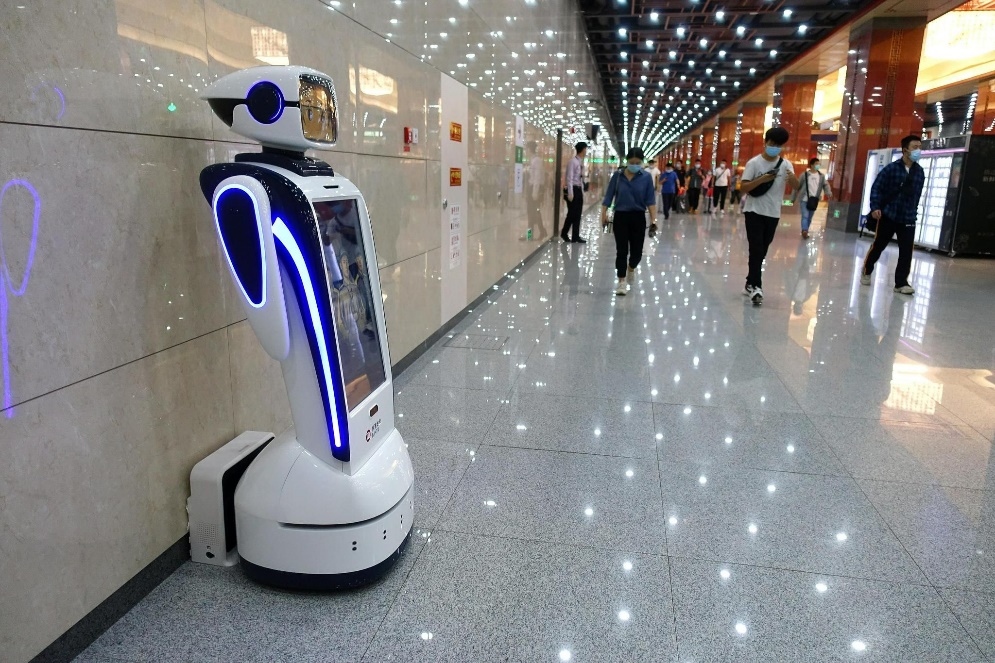
AI smart video technology can help the subway operating system. For example, Beijing ‘Fuxingmen’, ‘Hujialou’ or ‘Sihui’ subway stations all use AI smart video technology to do high-precision navigation. Because it has a very complex structure in some of Beijing subway stations and the area of subway stations is massive, passengers can use the Beijing subway intelligent service robot with the AI smart video technology to realize the navigation in the subway station with no extra signal. All Beijing subway stations have safety inspection systems to protect the passenger or subway station staff’s safety. The AI smart video technology is installed on the safety inspection system, so security inspectors can quickly complete the security checks and let all the passengers enter the subway station quickly. As a result, it can improve the efficiency of the passenger entering the subway station (Figure 1).
 |
|
|---|---|
| Figure 1. An intelligent service robot on the Beijing subway [10]. | |
5. Conclusion
This study analyzes the application of RS technologies in urban landscaping planning, environmental protection and transportation.
For urban landscaping planning, the RS and GIS technologies combining the qualification and three methods of organising green land brings a lot of convenience to urban landscaping planning. With the help of the RS and GIS technologies, it can monitor the change in area of wetland and the natural disasters and connect with AI technology to keep transportation safe.
For urban transportation, RS technology combined with AI smart video technology is widely used. It could help people solve problems of bad driving habits, prevent traffic accidents, and then decrease the loss of life safety property as soon as possible.
For environmental protection, RS technology is also important because RS technology can monitor the area change of wetlands in the city and help people to put out mountain fires. It is equal to remind people not to forget to protect the natural environment when they plan and build city and always notice the disasters that happen or will happen around the city.
Here are many RS technology methods in urban planning. However, different approaches have different benefits and disadvantages, and it is essential to make plans by combining other techniques.
References
[1]. Chen Jialu 2017. Comprehensive evaluation of urban green space system and construction of ecological green space System based on RS and GIS technologies-- A case study of Xi 'an City. Shandong Jianzhu University. 7
[2]. Mang Shen 2017. Comprehensive evaluation of urban green space system and construction of ecological green space system based on RS and GIS technologies-- Take Xi 'an City as an example. Shandong Jianzhu University. 13 16
[3]. Yin Peizhuo 2019. Quantitative study on the correlation between urban green land rate and green coverage rate--Take the main urban area of Rizhao City in Shandong Province as an example. Shandong Jianzhu University. 50-51
[4]. Xiang Biyin 2017. Research on Application of low altitude remote sensing image of UAV. Low Carbon World. 90
[5]. Zhang Qiang, Lu Hai-feng, Zhao Wen-Hui, Zhang Li-kun, LI Ling-jun. 2019. Analysis of remote sensing monitoring of urban wetlands in Beijing from 2016 to 2018. Environmental Monitoring and Early Warning, 11(5): 91-95.
[6]. The cloud to earth, 2022-09-01 Chongqing’s mountain fire review! Drone remote sensing is behind the scenes.
[7]. Shenzhen Traffic Police: Joint innovation with Huawei to create Pengcheng traffic intelligence, so that travel can be foreseen, from https://e.huawei.com/.
[8]. Ai B, Molisch AF, Rupp M, Zhong ZD. 2020. 5G key technologies for smart railways. Proceedings of the IEEE. 108(6):856-93.
[9]. Han P, Wang Z, Zhou C. 2022. Talking About the Application of Artificial Intelligence in Urban Rail Transit. InProceedings of 2021 Chinese Intelligent Systems Conference (pp. 219-228). Springer, Singapore.
[10]. An intelligent service robot on the Beijing subway has been unveiled. September 30, 2021 09:40 form https://t.cj.sina.com.cn/.
Cite this article
Sun,S.;Xiong,T. (2023). Application of Remote Sensing Technology in Sustainable Urban Planning and Development. Applied and Computational Engineering,3,283-288.
Data availability
The datasets used and/or analyzed during the current study will be available from the authors upon reasonable request.
Disclaimer/Publisher's Note
The statements, opinions and data contained in all publications are solely those of the individual author(s) and contributor(s) and not of EWA Publishing and/or the editor(s). EWA Publishing and/or the editor(s) disclaim responsibility for any injury to people or property resulting from any ideas, methods, instructions or products referred to in the content.
About volume
Volume title: Proceedings of the 3rd International Conference on Materials Chemistry and Environmental Engineering (CONF-MCEE 2023)
© 2024 by the author(s). Licensee EWA Publishing, Oxford, UK. This article is an open access article distributed under the terms and
conditions of the Creative Commons Attribution (CC BY) license. Authors who
publish this series agree to the following terms:
1. Authors retain copyright and grant the series right of first publication with the work simultaneously licensed under a Creative Commons
Attribution License that allows others to share the work with an acknowledgment of the work's authorship and initial publication in this
series.
2. Authors are able to enter into separate, additional contractual arrangements for the non-exclusive distribution of the series's published
version of the work (e.g., post it to an institutional repository or publish it in a book), with an acknowledgment of its initial
publication in this series.
3. Authors are permitted and encouraged to post their work online (e.g., in institutional repositories or on their website) prior to and
during the submission process, as it can lead to productive exchanges, as well as earlier and greater citation of published work (See
Open access policy for details).
References
[1]. Chen Jialu 2017. Comprehensive evaluation of urban green space system and construction of ecological green space System based on RS and GIS technologies-- A case study of Xi 'an City. Shandong Jianzhu University. 7
[2]. Mang Shen 2017. Comprehensive evaluation of urban green space system and construction of ecological green space system based on RS and GIS technologies-- Take Xi 'an City as an example. Shandong Jianzhu University. 13 16
[3]. Yin Peizhuo 2019. Quantitative study on the correlation between urban green land rate and green coverage rate--Take the main urban area of Rizhao City in Shandong Province as an example. Shandong Jianzhu University. 50-51
[4]. Xiang Biyin 2017. Research on Application of low altitude remote sensing image of UAV. Low Carbon World. 90
[5]. Zhang Qiang, Lu Hai-feng, Zhao Wen-Hui, Zhang Li-kun, LI Ling-jun. 2019. Analysis of remote sensing monitoring of urban wetlands in Beijing from 2016 to 2018. Environmental Monitoring and Early Warning, 11(5): 91-95.
[6]. The cloud to earth, 2022-09-01 Chongqing’s mountain fire review! Drone remote sensing is behind the scenes.
[7]. Shenzhen Traffic Police: Joint innovation with Huawei to create Pengcheng traffic intelligence, so that travel can be foreseen, from https://e.huawei.com/.
[8]. Ai B, Molisch AF, Rupp M, Zhong ZD. 2020. 5G key technologies for smart railways. Proceedings of the IEEE. 108(6):856-93.
[9]. Han P, Wang Z, Zhou C. 2022. Talking About the Application of Artificial Intelligence in Urban Rail Transit. InProceedings of 2021 Chinese Intelligent Systems Conference (pp. 219-228). Springer, Singapore.
[10]. An intelligent service robot on the Beijing subway has been unveiled. September 30, 2021 09:40 form https://t.cj.sina.com.cn/.