


1. Introduction
Bishan-Ang Mo Kio Park (BAP), completed in 2012, represents a natural based solution (NbS) for river parks in Singapore, introducing innovative hydrological management in tropical urban settings [1]. As a flagship of the ABC Water Programme, it exemplifies the integration of water supply, flood control, population density, and ecological prosperity with nature-based solutions[2-3]. The ASLA 2016 jury praised its flood management: "The hydrological and ecological pulses beat through this"[4]. Yet, this success was not immediate but the result of navigating the complexities of modernization and the interplay of socio-economic, political, and technological factors. Public awareness and education played crucial roles, as the government addressed pollution, germ spread due to hygiene education gaps, and business resistance to policy with regulations and educational campaigns in the late 20th century.
1.1. Early Settlements
The Kallang River, home to Bishan-Ang Mo Kio Park (BAP), is Singapore's longest river, historically providing both drinking water and fertile soil through seasonal floods. The Orang Kallang tribe settled in the Kallang Basin's mangroves "since time immemorial"[5-6]. The riverbanks once supported rice paddies and fishponds, as shown in an 1836 map, but shifted to higher-value crops like coconuts. Toa Payoh's agricultural lands lasted until the 1960s. The river basin saw the rise of sugar businesses, brick kilns, Gas Works, and later, dockyards and farms, playing a key role in commodity production and transportation[7-9]. However, the basin became highly polluted during the 19th and 20th centuries due to urbanization, population growth, industrial expansion, and uncontrolled discharge[9].
1.2. Indulgent Urbanization, Pollution, Virus and Flood
Bishan-Ang Mo Kio Park (BAP) stands on a site that has retained its original character as a vast, untouched swamp, despite the urbanization of the Kallang River basin[10]. Established in 1910, the Lower Peirce Reservoir is a crucial source of fresh water for Singapore, located near BAP. The area, including Peck San Theng, has a rich history, with the Kampong San Teng community emerging since 1870.
Urbanization, driven by population growth and industrialization, led to significant pollution in the Kallang River basin, earning it the nickname "Dead Chicken River" due to fish farm pollution and improper waste disposal[11]. This environmental degradation heightened the risk of epidemics, underlining the need for policy and ecological awareness.
Cholera, associated with untreated water systems, has a long history in Singapore, with major outbreaks in the 19th century. The link between cholera and contaminated water was only revealed after John Snow's study in 1854[12]. Poor public hygiene, like eating unwashed produce and shellfish from the Singapore River, contributed to cholera infections[13]. The absence of a sewage treatment system until 1889 worsened this, leading to contaminated water sources and disease spread[14].
Floods have been a persistent threat, with the severe flood in 1964 and the catastrophic flood in December 1978 (Figure 1), which caused an estimated $3 million in losses[15], highlighting the inadequacy of human-made systems against natural disasters[11]. These historical accounts underscore the critical role of policy, infrastructure, and public awareness in managing water resources, preventing disease, and implementing effective flood mitigation strategies in urban environments.
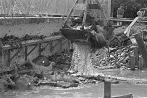
Figure 1: Fishing up dead pigs from Kallang River after the 1978 Flood [15].
1.3. Modern River Policy in Singapore
In 1969, Singapore's government initiated policies for river management, with Prime Minister Lee Kuan Yew directing the Public Works Department and Public Utilities Board to develop a plan to clean waterways and curb pollution[8]. The 'Ten-Year Clean Rivers' plan, launched in 1977, aimed to improve environmental health and support socio-economic development, also addressing water security due to Singapore's reliance on Malaysian water imports[16]. Implementation faced challenges, including the resettlement of households, farms, and industries, and resistance from the lighterage industry and shipyards, which only began relocating after an industry downturn in 1983[17-18]. The Clean Rivers Education Programme, launched in 1986, aimed to change public perceptions and promote environmental protection through education and legal measures[19].
The technical renovation of the river space is crucial, with the government ensuring recreational access for the public. Bishan Park, a precursor to BAP, was built as a buffer between Bishan and Ang Mo Kio from 1983 to 1988. The Housing Development Board (HDB) introduced satellite residential developments in these areas, marking a departure from the typical HDB brutalism design, with houses designed for aesthetic appeal and equipped with amenities[20]. The Kallang River's improvement was part of regional visions and national policies, and the new park provided green spaces for residents to enjoy nature, as highlighted by The Straits Times (Figure 2).
"Loh Peng Wah, a senior architect from HDB, said Bishan Park, which is situated among the high-rise residences, will serve as a buffer zone between Ang Mo Kio and Bishan New Town ...... (The first phase of the project) will include jogging and cycling trails; a palm court, a garden with palm trees and colorful shrubs; a pond; a multi-purpose court; a lake; a floating amphitheater; a fitness corner; and a soccer field. ......"[21].
Despite criticisms of Bishan Park (BP), its contributions to Singapore's parks system, initiated in 1992, should be recognized. The park was part of a vision to create an island-wide corridor network along drainage canals for continuous outdoor activities[22]. Although the Kallang River was channelized, it was not concealed; instead, it featured ponds and lakes that invited scenic and tactile engagement, reflecting a shift towards leisure and nature appreciation. This integration of natural and cultural elements marked a significant evolution in urban design. However, Bishan Park had limited accessibility from the south, with bridge distances over 400 meters, indicating a need for future improvements.

Figure 2: Plan of Bishan Park, from the The Straits Times, 1986, edited by author.
The Active, Beautiful, and Clean Waters Programme (ABC), initiated by PUB in 2006, marked a transformation for Bishan Park and its canal, which reopened in 2012. The park's revamp showcased contemporary landscape ideals with technological innovations, such as widening the river for floodable zones, using soil bioengineering to secure riverbanks, and prioritizing natural biological evolution without chemical intervention in water purification[22]. The ABC Water program aimed to enrich the living environment, cater to recreational needs, and enhance water quality, building on prior river policies. Initially piloted on a small scale with three canal projects and an ecological testbed, the program confirmed the feasibility of using natural processes for rainwater purification. Subsequently, PUB expanded the program to 30 sites nationwide, with Bishan-Ang Mo Kio Park as a flagship, and engaged the public through exhibitions to raise awareness about waterways' value and development potential.
The government's initiative with the Active, Beautiful, and Clean Waters Programme (ABC Waters) sought public support and confidence, recognizing the importance of integrating water spaces into daily life and encouraging community involvement in maintaining cleanliness[23]. Bishan Park's redesign facilitated closeness to water, with meandering waterways and floodable areas enhancing accessibility and addressing previous disconnections. The park enabled direct interaction with water through platforms and stepping stones, promoting a hands-on approach to water activities. Local stakeholders were also engaged through initiatives like ABC Waters Learning Trails, fostering community and sustainable projects.
Technologically, the park integrated dynamic systems—focusing on soil, hydrology, and vegetation—with techniques like river widening, floodable zones, soil bioengineering, and chemical-free water purification. This approach demonstrated a commitment to urban resilience, especially in disaster scenarios.
To conclude, in this chapter, we will use the landscape along Kallang River as a guide to explore how human societies within the watershed perceive, utilize, and impact rivers. We are trying to encompass a hidden array of public and commercial interests, the evolving dynamics of technological advancements, and the interplay of water relationships.
2. The case study of Bishan-Ang Mo Kio Park
2.1. Concept generation
Looking at the Kallang River in the 21st century, it is easy to see that the management and maintenance system of the Kallang River has the shadow of the 20th century. But at the same time, new policies and programs have been implemented to rehabilitate the Kallang River, including the construction of Bishan-Ang Mo Kio Park.
Launched in 2006, by Singapore’s national water agency Public Utilities Board (PUB), the Active, Beautiful and Clean (ABC) Waters Program seamlessly transforms the country’s network of utility drains, canals and reservoirs into vibrant and beautiful Streams, rivers and lakes are integrated with their adjacent land development, allowing space near the Kallang River to be used for recreation and community connections.
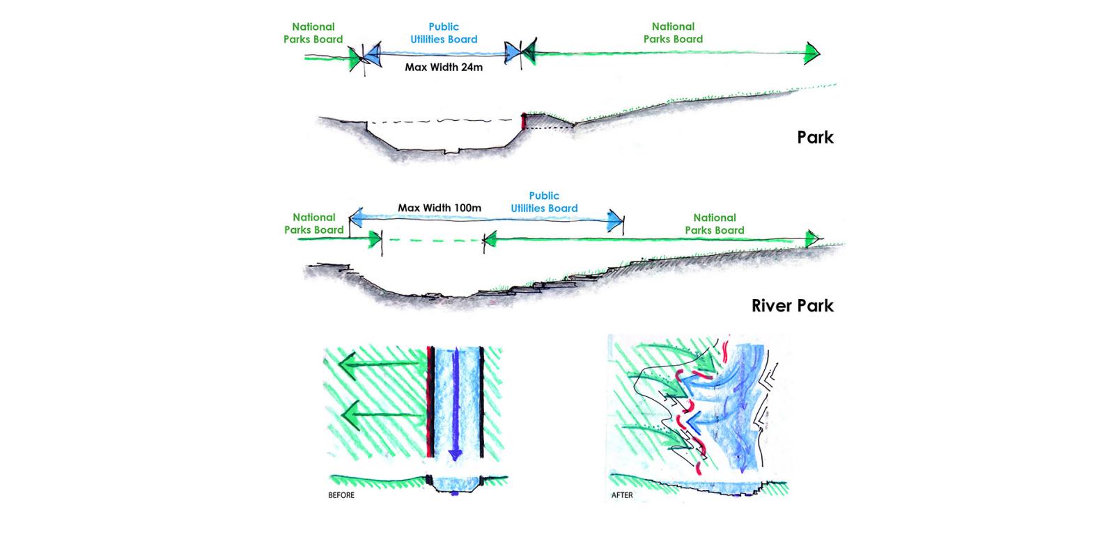
Figure 3: Multi-agency collaboration[1]
The restoration of Park through a joint partnership between PUB and the National Parks Board (NParks) illustrates how government agencies and different disciplines such as parks and water can work together to address current challenges and opportunities (Figure 3)[4]. Also proved that the simple act of "getting closer to the water" not only allows the community to experience the rhythms of nature but also has a profound impact on social perceptions and the sense of stewardship of the surrounding environment.
2.2. Process of the Project
The meticulous planning by Atelier Dreiseitl and CH2M Hill transformed Bishan-Ang Mo Kio Park through a species diversity study and soil bioengineering techniques[4]. A river simulation model was key in understanding water dynamics, enhancing flood protection, and segregating park space for varying water levels[24]. The "learning-by-doing" approach minimized construction risks. Community engagement through Friends of Kallang River @ Bishan-Ang Mo Kio Park boosted public enjoyment and stewardship[25]. Ecological purification, using vegetation-based filtration, supported biodiversity and ecosystem resilience. The park's design also serves as an educational space for children, promoting water conservation. Community involvement, including children's contributions and monitoring river health, highlights the park's role in fostering environmental responsibility (Figure 4)[26].
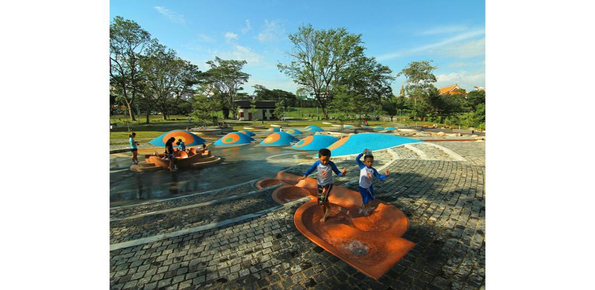
Figure 4: Children splashing in the completed park[4]
Community involvement will be a highlight of the completed project, as children will draw lovely designs for the park, will help pick up litter from the river, monitor the health of the river's waters, and make it a teaching pathway. In addition, this park has become home to a family of otters. Their presence attracted the attention of the local media and residents[4]. It was a testament to the re-naturalisation of the river. The resulting responsible use of water by social groups makes future water sources potentially much more costly than current ones (PUB 2011) to ensure their long-term responsible use[26].
2.3. Summary
Bishan-Ang Mo Kio Park exemplifies the successful application of nature-based solutions (NbS) in the Kallang River's restoration[4]. The project's triumph stems from government policies, meticulous design, and community engagement in water management. Public involvement transcends planning, extending to implementation and active learning, which shapes attitudes and behaviors towards sustainable practices. This collective stewardship has been pivotal from inception to current management, highlighting the importance of diverse community participation.
3. Conclusion
The management of Singapore's Kallang River has advanced through policy and design innovations, embodying the city-state's urbanization and quest for integrated water management[4]. Political leadership and water governance have underpinned Singapore's achievements, with ongoing public engagement in conservation.
A cooperative model involving diverse stakeholders has become integral to water resources management, promoting inclusive decision-making and collaborative governance[4]. Nature-based Solutions (NbS) address urban flood risks and enhance socio-cultural services, as illustrated by Bishan-Ang Mo Kio Park. This park exemplifies effective water purification, plant selection, and the promotion of species diversity, aiming to restore natural ecology and avoid excessive artificialization[1].
Public education strategies, such as those at Bishan-Ang Mo Kio Park, are designed to encourage sustainable water use by influencing societal attitudes and behaviors[26]. The park's design facilitates learning about hydrology and water management activities, setting a precedent for educational initiatives.
Ultimately, Bishan Ang Mo Kio Park stands out as a model of ecological infrastructure in urban parks, integrating water resources, flood control, biodiversity, and recreation. It fosters an emotional bond with water and a sense of civic duty towards water resource stewardship.
References
[1]. Cui, Mengmeng, Filipa Ferreira, Tze Kwan Fung, and José Saldanha Matos. "Tale of Two Cities: How Nature-Based Solutions Help Create Adaptive and Resilient Urban Water Management Practices in Singapore and Lisbon." Sustainability (Basel, Switzerland) 13, no. 18 (2021): 10427.
[2]. Padigala, Bhaskar. "Exploring City Branding as a Tool to Conserve Urban Green Infrastructure in Developing Countries." 1406-33: IGI Global, 2017.
[3]. "Collaboration on Nature-Based Solutions Is Key to Resilient City Infrastructure." World Resources Institute, Updated 29 June, 2020, https://www.preventionweb.net/news/collaboration-nature-based-solutions-key-resilient-city-infrastructure
[4]. "2016 Asla Professional Awards: Bishan-Ang Mo Kio Park." 2016, https://www.asla.org/2016awards/169669.html.
[5]. Benjamin, Geoffrey, and Cynthia Chou. Tribal Communities in the Malay World : Historical, Cultural and Social Perspectives. Singapore: Institute of Southeast Asian Studies, 2002.
[6]. Sather, Clifford. "The Sea Nomads: A Study Based on the Literature of the Maritime Boat People of Southeast Asia . David E. Sopher." American anthropologist 69, no. 1 (1967): 111-12.
[7]. Yi, Tan Jia. "Kallang: A Trailblazer." MuseSG Volume 11 Issue 1 - 2018 (2018).
[8]. "Clean-up of Singapore River and Kallang Basin." National Library Board, https://www.nlb.gov.sg/main/article-detail?cmsuuid=21837345-389f-4856-a82d-a5415c7bb55b#:~:text=Without%20proper%20sewage%20facilities%2C%20squatters,farms%20adding%20to%20the%20problem.
[9]. Chan, David, and Mui Teng Yap. 50 Years of Social Issues in Singapore. World Scientific Series on Singapore: 50 Years of Nation-Building. Singapore ;: World Scientific, 2015.
[10]. Choi, Chi-cheung. "Ancestors Are Watching: Ritual and Governance at Peck San Theng, a Chinese Afterlife Care Organization in Singapore." Religions (Basel, Switzerland ) 11, no. 8 (2020): 382.
[11]. "The Cleaning up of Singapore River and Kallang Basin (1977-1987)." 2012, 2023, https://otterman.wordpress.com/2012/09/23/the-cleaning-up-of-singapore-river-and-kallang-basin-1977-1987/.
[12]. Gandy, Matthew. The Fabric of Space: Water, Modernity, and the Urban Imagination. The Mit Press. 1 ed. Cambridge: The MIT Press, 2014.
[13]. Lee, Yong Kiat. The Medical History of Early Singapore. Publication ; No. 14. Tokyo: Southeast Asian Medical Information Center, 1978.
[14]. Yeoh, Brenda S. A. "Urban Sanitation, Health and Water Supply in Late Nineteenth and Early Twentieth Century Colonial Singapore." South East Asia research 1, no. 2 (1993): 143-72.
[15]. (SPH), SINGAPORE PRESS HOLDINGS. "Fishing up Dead Pigs from Kallang River after the 1978 Flood." In National Archives of Singapore, edited by Picture of 1978 Flood. Singapore: SINGAPORE PRESS HOLDINGS (SPH), 1978.
[16]. Cheam, J. Forging a Greener Tomorrow: Singapore's Environmental Journey from Slum to Eco-City. Straits Times Press, 2012.
[17]. Sustainable Environment : Balancing Growth with the Environment. Singapore: Cengage Learning Asia Pte Ltd., 2013.
[18]. Hon, J., and Singapore. Ministry of the Environment. Tidal Fortunes: A Story of Change, the Singapore River and Kallang Basin. Landmark Books, 1990.
[19]. Joshi, Yugal Kishore, Cecilia Tortajada, and Asit K. Biswas. "Cleaning of the Singapore River and Kallang Basin in Singapore: Human and Environmental Dimensions." Ambio 41, no. 7 (2012): 777-81.
[20]. GIOK, OEI SIN. "Unique Hdb Designs for Bishan." Singapore Monitor, 30 Nov. 1984, 1.
[21]. Tan, Judy. "$8.5 M Park for Ang Mo Kio and Bishan." The Straits, 1986, 1.
[22]. Dhanabalan, S. "Speech by S Dhanabalan, Minister for National Development at the Opening of the Park Network System, Kallang River Phase I on Friday 14 Aug 92 at 5.00 Pm at Kallang River Park Connector (Bishan Road)." Singapore: National Achives of Singapore.
[23]. Centre for Liveable Cities, Singapore. The Active, Beautiful, Clean Waters Programme: Water as an Environmental Asset. Centre for Liveable Cities, Singapore, 2017.
[24]. Ahern, Jack.“From Fail-Safe to Safe-to-Fail: Sustainability and Resilience in the New Urban World.”Landscape and urban planning 100, no. 4 (2011): 341–343.
[25]. River, Kallang. "Integrating River and Park in an Urban World."
[26]. Tortajada, Cecilia, and Yugal K. Joshi. “Water Demand Management in Singapore: Involving the Public.” Water resources management 27, no. 8 (2013): 2729–2746.
Cite this article
Wang,X.;Li,H. (2024). Enhancing Public Education of Water Resource Conservation Through Urban Landscape: A Case Study of Bishan-Ang Mo Kio Park in Singapore. Communications in Humanities Research,45,25-31.
Data availability
The datasets used and/or analyzed during the current study will be available from the authors upon reasonable request.
Disclaimer/Publisher's Note
The statements, opinions and data contained in all publications are solely those of the individual author(s) and contributor(s) and not of EWA Publishing and/or the editor(s). EWA Publishing and/or the editor(s) disclaim responsibility for any injury to people or property resulting from any ideas, methods, instructions or products referred to in the content.
About volume
Volume title: Proceedings of the 3rd International Conference on Art, Design and Social Sciences
© 2024 by the author(s). Licensee EWA Publishing, Oxford, UK. This article is an open access article distributed under the terms and
conditions of the Creative Commons Attribution (CC BY) license. Authors who
publish this series agree to the following terms:
1. Authors retain copyright and grant the series right of first publication with the work simultaneously licensed under a Creative Commons
Attribution License that allows others to share the work with an acknowledgment of the work's authorship and initial publication in this
series.
2. Authors are able to enter into separate, additional contractual arrangements for the non-exclusive distribution of the series's published
version of the work (e.g., post it to an institutional repository or publish it in a book), with an acknowledgment of its initial
publication in this series.
3. Authors are permitted and encouraged to post their work online (e.g., in institutional repositories or on their website) prior to and
during the submission process, as it can lead to productive exchanges, as well as earlier and greater citation of published work (See
Open access policy for details).
References
[1]. Cui, Mengmeng, Filipa Ferreira, Tze Kwan Fung, and José Saldanha Matos. "Tale of Two Cities: How Nature-Based Solutions Help Create Adaptive and Resilient Urban Water Management Practices in Singapore and Lisbon." Sustainability (Basel, Switzerland) 13, no. 18 (2021): 10427.
[2]. Padigala, Bhaskar. "Exploring City Branding as a Tool to Conserve Urban Green Infrastructure in Developing Countries." 1406-33: IGI Global, 2017.
[3]. "Collaboration on Nature-Based Solutions Is Key to Resilient City Infrastructure." World Resources Institute, Updated 29 June, 2020, https://www.preventionweb.net/news/collaboration-nature-based-solutions-key-resilient-city-infrastructure
[4]. "2016 Asla Professional Awards: Bishan-Ang Mo Kio Park." 2016, https://www.asla.org/2016awards/169669.html.
[5]. Benjamin, Geoffrey, and Cynthia Chou. Tribal Communities in the Malay World : Historical, Cultural and Social Perspectives. Singapore: Institute of Southeast Asian Studies, 2002.
[6]. Sather, Clifford. "The Sea Nomads: A Study Based on the Literature of the Maritime Boat People of Southeast Asia . David E. Sopher." American anthropologist 69, no. 1 (1967): 111-12.
[7]. Yi, Tan Jia. "Kallang: A Trailblazer." MuseSG Volume 11 Issue 1 - 2018 (2018).
[8]. "Clean-up of Singapore River and Kallang Basin." National Library Board, https://www.nlb.gov.sg/main/article-detail?cmsuuid=21837345-389f-4856-a82d-a5415c7bb55b#:~:text=Without%20proper%20sewage%20facilities%2C%20squatters,farms%20adding%20to%20the%20problem.
[9]. Chan, David, and Mui Teng Yap. 50 Years of Social Issues in Singapore. World Scientific Series on Singapore: 50 Years of Nation-Building. Singapore ;: World Scientific, 2015.
[10]. Choi, Chi-cheung. "Ancestors Are Watching: Ritual and Governance at Peck San Theng, a Chinese Afterlife Care Organization in Singapore." Religions (Basel, Switzerland ) 11, no. 8 (2020): 382.
[11]. "The Cleaning up of Singapore River and Kallang Basin (1977-1987)." 2012, 2023, https://otterman.wordpress.com/2012/09/23/the-cleaning-up-of-singapore-river-and-kallang-basin-1977-1987/.
[12]. Gandy, Matthew. The Fabric of Space: Water, Modernity, and the Urban Imagination. The Mit Press. 1 ed. Cambridge: The MIT Press, 2014.
[13]. Lee, Yong Kiat. The Medical History of Early Singapore. Publication ; No. 14. Tokyo: Southeast Asian Medical Information Center, 1978.
[14]. Yeoh, Brenda S. A. "Urban Sanitation, Health and Water Supply in Late Nineteenth and Early Twentieth Century Colonial Singapore." South East Asia research 1, no. 2 (1993): 143-72.
[15]. (SPH), SINGAPORE PRESS HOLDINGS. "Fishing up Dead Pigs from Kallang River after the 1978 Flood." In National Archives of Singapore, edited by Picture of 1978 Flood. Singapore: SINGAPORE PRESS HOLDINGS (SPH), 1978.
[16]. Cheam, J. Forging a Greener Tomorrow: Singapore's Environmental Journey from Slum to Eco-City. Straits Times Press, 2012.
[17]. Sustainable Environment : Balancing Growth with the Environment. Singapore: Cengage Learning Asia Pte Ltd., 2013.
[18]. Hon, J., and Singapore. Ministry of the Environment. Tidal Fortunes: A Story of Change, the Singapore River and Kallang Basin. Landmark Books, 1990.
[19]. Joshi, Yugal Kishore, Cecilia Tortajada, and Asit K. Biswas. "Cleaning of the Singapore River and Kallang Basin in Singapore: Human and Environmental Dimensions." Ambio 41, no. 7 (2012): 777-81.
[20]. GIOK, OEI SIN. "Unique Hdb Designs for Bishan." Singapore Monitor, 30 Nov. 1984, 1.
[21]. Tan, Judy. "$8.5 M Park for Ang Mo Kio and Bishan." The Straits, 1986, 1.
[22]. Dhanabalan, S. "Speech by S Dhanabalan, Minister for National Development at the Opening of the Park Network System, Kallang River Phase I on Friday 14 Aug 92 at 5.00 Pm at Kallang River Park Connector (Bishan Road)." Singapore: National Achives of Singapore.
[23]. Centre for Liveable Cities, Singapore. The Active, Beautiful, Clean Waters Programme: Water as an Environmental Asset. Centre for Liveable Cities, Singapore, 2017.
[24]. Ahern, Jack.“From Fail-Safe to Safe-to-Fail: Sustainability and Resilience in the New Urban World.”Landscape and urban planning 100, no. 4 (2011): 341–343.
[25]. River, Kallang. "Integrating River and Park in an Urban World."
[26]. Tortajada, Cecilia, and Yugal K. Joshi. “Water Demand Management in Singapore: Involving the Public.” Water resources management 27, no. 8 (2013): 2729–2746.