


1. Introduction
The rapid advancement of computer technologies, such as artificial intelligence, big data, and digital twins—is driving a profound paradigm shift in smart city planning concepts. Traditional urban planning methods encounter limitations, such as static modeling, challenges in integrating multi-source data, and inadequate public participation. In contrast, emerging technologies offer systematic solutions to these issues. Employing a three-dimensional analytical framework—"technological empowerment, spatial evolution, and governance innovation"—this paper reviews current technological approaches for reconstructing urban spatial structures, governance models, and public engagement mechanisms. The focus includes BIM 5D [1], digital twins, GIS/CIM integration, knowledge graphs, and integrated human-machine collaboration systems. Through case studies, dynamic modeling experiments, social network analysis, and Delphi investigations, this paper assesses the multidimensional impacts of technological innovation on planning efficiency, governance synergy, and ethical risks. Studies indicate that smart city development must transcend the limitations of "instrumental rationality," emphasizing scientific rigor, inclusivity, and interpretability [2]. Thus, the future of smart cities depends not only on advanced computer technologies but also on effectively integrating spatial design with ethical frameworks and meaningful human participation. Consequently, establishing an interdisciplinary governance mechanism is recommended to facilitate the coordinated evolution of technical standards, spatial policies, and ethical norms, thereby fostering future cities characterized by greater humanistic care and social resilience.
2. Reconstruction and upgrading of the urban planning tool chain system
2.1. Construction of a new generation toolchain
China's "Smart Construction Site + BIM" system has emerged relatively late. Currently, traditional large-scale urban planning projects primarily utilize two-dimensional (2D) data images for process management. However, these images cannot intuitively reflect existing issues or real-time project progress, consequently affecting the overall efficiency of management and problem-solving in urban planning. With advancements in BIM technology, BIM5D has introduced practice and cost dimensions on top of the existing 3D BIM. BIM5D technology innovations significantly enhance supervision efficiency, mitigate issues, such as information loss and poor communication, and substantially reduce supervision costs. According to the China Construction Industry BIM Application Analysis Report (2023), over 86% of general contracting enterprises in construction develop their own BIM models. Among those enterprises utilizing BIM technology for over three years, 60.84% have continually increased investment annually, while 20.51% maintain steady annual investment [3].
According to the survey, approximately 37% of construction enterprises currently use BIM technology, while around 42% have previously applied it. Therefore, genuinely popularizing BIM5D technology in major municipal planning projects and comprehensively reconstructing urban planning toolchains, rather than merely promoting them superficially, has become imperative. As BIM technology rapidly advances, complementary developments in Geographic Information System (GIS) technology continue apace. Integrating BIM and GIS data into a unified database is critical to fundamentally enhancing decision-making and data management efficiency in planning projects [4]. The advantage of GIS lies in providing and integrating large-scale macro geographic information data, such as analyzing various geographic data information in urban planning, disaster prediction and environmental detection. Conversely, BIM excels in processing refined micro-scale information within buildings or construction sites. Therefore, it is an important step to solve the coordination problem between the two in planning projects to promote the reconstruction of the planning tool chain system. Several studies have proposed methods for integrating GIS and BIM data [5]. Collaboration between BIM and GIS typically involves Industry Foundation Classes (IFC) or proprietary data formats alongside the 3D Tiles standard, aiming for seamless integration and efficient use of data through standardized conversion processes. Research and development efforts focus on efficient IFC or proprietary-to-3D Tiles conversion tools and algorithms, ensuring data integrity and consistency throughout the conversion process. During the transformation process, key issues include precise representation of geometric information, structured storage of attribute data, and optimization of data structures.Smart cities are progressively digitizing urban basic information and optimizing operational and management efficiency through various advanced computational techniques. However, extensive digitalization has resulted in complex and diverse urban digital information. Additionally, due to a lack of technical standardization across various software and technologies, there are significant differences in the types and accuracy of generated data. Thus, unifying and integrating multi-source, heterogeneous, and massive data in smart cities is an urgent issue requiring attention. Several studies have proposed methods for processing multi-source heterogeneous data in smart cities using knowledge graph technology [6].
The specific methods are as follows: (1) First, data preprocessing is performed by eliminating characteristic differences in preliminary cleaned redundant data using Z-score standardization. Subsequently, field identifiers from different data sources are unified to ensure semantic consistency. (2) Second, a knowledge graph is constructed by identifying entities (e.g., traffic and environmental monitoring data) from text and establishing semantic associations using relationship extraction models. These entity relationships are then stored in graph structures to resolve entity heterogeneity. (3) Third, data fusion is achieved by calculating the semantic similarity between entities using the knowledge graph. Similarities guide the matching of entities from various sources, selecting optimal entities, merging redundant data, and dynamically aligning data schemas to ensure consistency. By addressing multi-source heterogeneous data via knowledge graphs, data redundancy is reduced to less than 2% across numerous areas, including transportation, environment, public transit, public safety, business activities, and social media. However, this proposed method still faces challenges, including the need for more intelligent mapping techniques to improve matching accuracy, as well as privacy protection measures to safeguard sensitive information potentially exposed during data fusion. The development of deep learning capabilities may enhance data fusion accuracy, standardize and generalize knowledge graphs, and expand their applications beyond smart city data management to broader urban humanities fields.
2.2. Digital twin and spatial simulation
Digital twin technology employs digital methods to create virtual models that accurately correspond to their physical counterparts. It enables full-cycle monitoring and optimization of physical entities through real-time, efficient data interaction. Leveraging this capability, digital twin technology significantly benefits smart city development. Smart city construction is a long-term and complex systems engineering project. Digital twins can notably enhance smart city engineering by virtue of timely data interaction, efficient operational interactions, and flexible technological scalability. The traditional concept of geospace focuses primarily on physical and human spaces; however, advancements in digital technology and information networks have expanded spatial dimensions from purely physical areas to digital dimensions [7]. Driven by digital twin technology, digital, geographical, and human dimensions closely intertwine, forming a three-dimensional digital twin city. In a digital twin city, the geographical dimension describes environmental and physical states, the human dimension analyzes urban functions and social behaviors, and the digital dimension enables real-time, bidirectional virtual-real interaction through data integration and algorithmic modeling. These three dimensions mutually map onto each other, ensuring accurate digital twin simulations, supporting intelligent optimization, continuous evolution of digital cities, and facilitating comprehensive collaborative representation within this ternary space (see Figure 1).
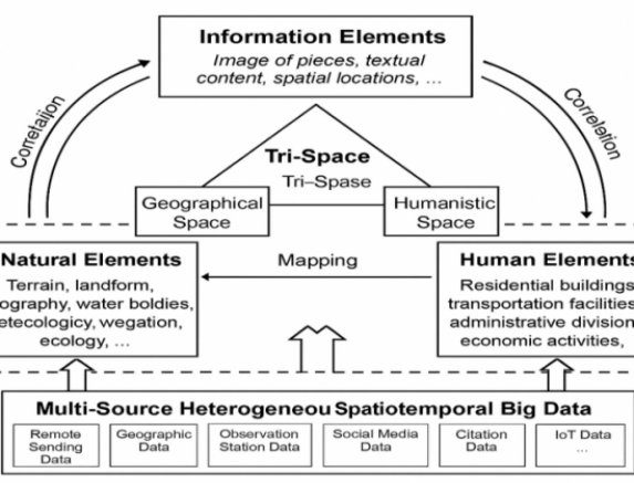
Thus, digital twin cities effectively reflect geographical, humanistic, and informational spaces of real physical cities. In this ternary space, the full spectrum of a smart city's information is comprehensively represented. However, conventional scanning methods for visualizing digital twin cities often capture only exterior surfaces within this ternary space. Due to differences in materials and geometric models, these methods are generally unsuitable for visualizing interior spaces, underground pipelines, and subsurface infrastructure. To address this technical challenge, recent research has achieved breakthroughs by developing multi-level, multi-type collaborative index structures and hierarchical filtering mechanisms for fast and accurate querying. Specifically, the multi-level, multi-type hybrid 3D spatial indexing method employs a quadtree grid as the primary index to rapidly locate local 3D model objects. Subsequently, improved R-tree and K-D tree structures serve as secondary indices to accurately retrieve both above-ground and underground targets while considering their Level of Detail (LOD) characteristics. A structurally balanced 3D R-tree expansion method is applied to above- and below-ground building models characterized by discrete distributions, varying geometries, and multiple levels of detail. By incorporating Level of Detail (LOD) models, intermediate nodes simultaneously support both target querying and detail-level selection. A global node selection algorithm combining bottom-up and top-down strategies ensures uniform node sizes, regular geometries, and reduced spatial overlap. To accommodate the hierarchical continuity, irregular morphology, complex topology, and rich attribute sets of geological models, a topology-aware 3D spatial indexing method is employed to enhance data query and retrieval efficiency [7].
A digital twin city platform functions as a centralized data hub, storing massive amounts of multi-source, heterogeneous data from smart city systems. Based on this foundation, processes, such as filtering, computation, association, sharing, and integration of heterogeneous multi-source data, can be effectively implemented. These processes form a critical component of the future development of smart cities. Once this extensive technological framework is fully developed, it will enable greater public participation in urban development through diverse visualization methods. Currently, Shenzhen, China, is actively developing a digital twin city, and the technologies discussed in this article serve as valuable references for constructing its digital twin platform.
3. Human-machine collaboration technologies
Throughout history, across all eras and societies, vulnerable groups have consistently required attention and should never be overlooked. Vulnerable groups can be defined from various perspectives, including physiological, cultural, and institutional dimensions. From the perspective of urban planning, vulnerable groups are of particular importance. In urban contexts, vulnerable groups typically include individuals with limited economic resources and reduced physical resilience. When social challenges escalate, these populations often experience the greatest instability and are most susceptible to adverse impacts [8]. Prioritizing the needs of vulnerable populations in smart city development not only reflects a human-centered planning philosophy but also significantly mitigates their social instability.
With continuous advancements in human–machine collaboration mechanisms and data acquisition systems, both public participation in urban design and the quality of data related to vulnerable groups have been significantly enhanced. This paper focuses on physiologically vulnerable populations who face difficulties using public transportation due to physical impairments. Public transportation is an essential component of urban development and plays a critical role in addressing the growing transportation demands associated with urban expansion. However, individuals with physical impairments frequently encounter significant barriers when accessing public transportation systems. This issue has received growing academic attention. To address the mobility challenges faced by these vulnerable populations, researchers have leveraged modern technologies to optimize bus stop allocation and design intelligent, convenient, and efficient public transit environments tailored to their characteristics and individual needs. For example, by integrating big data and digital platforms, functions such as real-time bus updates, vehicle congestion indicators, and barrier-free vehicle recognition have been implemented. Using AI and algorithmic analysis of data uploaded by disabled users, researchers can identify specific pain points and generate optimized public transit routes for each individual [9].
4. Regulation and governance of smart city construction
The application of technology has always been a double-edged sword for humanity. Technological advancements have undeniably brought great convenience and elevated human civilization to new heights. From the perspective of smart city construction and planning, this paper outlines various technologies that have transformed traditional urban planning methods and concepts. However, while these technologies advance urban systems, they often overlook an equally vital component of the city—its people. Ultimately, the core purpose of urban development and planning is to serve the needs of its inhabitants [10]. Overemphasizing technological development risks neglecting fundamental human needs in favor of superficial progress. Therefore, the tension between technological implementation and humanistic care is a critical issue that warrants attention in the development of smart city technologies.
According to the literature, humanistic care refers to concern for individuals' living conditions, and attention to their well-being, life, and health. It emphasizes deep concern for individuals' mental states and human nature, respect for emotions, will, and values; affirmation of human dignity and living conditions aligned with human nature; pursuit of personal freedom and liberation; protection of fundamental rights; and recognition of independent thought and individuality [11]. From a literature perspective, the integration of artificial intelligence and big data into smart city systems may result in unfair or negligent decisions toward vulnerable populations due to algorithmic bias, potentially exacerbating social tensions. In terms of personal privacy, the advancement of urban surveillance technologies and data networking systems is intensifying the conflict between data transparency and privacy protection. Therefore, it is essential to ensure that the application and development of all technologies are conducted under the oversight of ethical standards and fairness. As monitoring technologies evolve, identity authentication systems have also been progressively developed and refined. These technologies can be deployed across various Internet of Things (IoT) nodes and service sites within smart cities to safeguard core urban data and ensure accurate identity verification [12]. At the same time, urban administrators particularly government entities must carefully determine which data can be made public and which requires restricted access. They are also responsible for enhancing oversight of emerging technologies and improving the cybersecurity defenses such as firewall resilience provided by network operators.
5. Conclusion
As computer technologies such as big data, artificial intelligence, and digital twins integrate into smart city planning systems, the paradigm is shifting from technical rationality to cognitive collaboration. This paper focuses on how computer and human–machine collaborative technologies reconstruct the urban planning toolchain, while also emphasizing the need to enhance public participation. Future research should center on the themes of technological ethics and governance innovation, and this paper proposes and illustrates three key dimensions: technological reconstruction, collaborative empowerment, and ethical response [13]. First, technologies such as BIM 5D, GIS, knowledge graphs, and digital twins collaboratively construct the dynamic toolchain of smart cities. These tools enable a transition from two-dimensional static design to three-dimensional spatial simulation, and from isolated data collection to semantic integration—significantly improving planning accuracy and operational feasibility [14]. Second, next-generation participation platforms—enabled by human–machine collaboration—are facilitating a shift in the role of the public, especially vulnerable groups, from passive recipients to active co-creators. Technologies such as intelligent perception and multi-modal interaction are breaking down the barriers of technical elitism in traditional urban governance, thereby enhancing the authenticity and inclusivity of public participation. Finally, rapid technological advancement has brought ethical challenges to urban governance—including data privacy concerns, algorithmic bias, and the digital divide—which urgently require institutional responses and innovative governance mechanisms. Building interdisciplinary governance mechanisms, public oversight platforms, and ethical evaluation frameworks is essential to achieving the organic integration of scientific advancement and humanistic care in smart city development. In summary, the future of smart city planning depends not only on the advancement of cutting-edge computer technologies, but also on robust public participation and a sound ethical governance system. Only through the integration of technology, spatial planning, and humanistic values can we establish a new paradigm for smart cities that are both sustainable and socially responsive.
References
[1]. Xiaoli Zhao. Research on the whole process management of large-scale smart city construction projects based on BIM 5D technology [J]. Shanxi Institute of Technology and Business, Taiyuan, 030006.
[2]. Tianhu Deng, Keren Zhang, Zuojun (Max) Shen. A systematic review of a digital twin city: A new pattern of urban governance toward smart cities [J]. Journal of Management Science and Engineering, 2021(6): 125-134.
[3]. Editorial Board of China's Construction Industry BIM Application Analysis Report (2021). China's Construction Industry BIM Application Analysis Report (2021) [M]. Beijing: China Architecture & Building Press, 2021.
[4]. Jie Zheng, Wenqiang Chen. Analysis of Obstacles and Countermeasures in the Promotion and Application of BIM in the Construction Industry [J] Shanxi architecture, 2020, 46(21): 187-192.
[5]. Kun Wu. Research on data collaboration system based on BIM and GIS [J]. Internet Weekly, 2024, 15(12): 15.
[6]. Xuan Zhou. Research on the fusion method of smart city and multi-source heterogeneous big data under knowledge graph technology [J]. Records of information2025, 26(1): 232-237.
[7]. Jun Zhao, Chenghua Yu, Yonghua Lu, Yebin Chen. Multi-source data fusion of 3D digital base for digital twin city [J/OL].New Urban Construction Technology, August 2024, 33(8).
[8]. Song Wang, Jingnan Huang, Cunsong Wang, Junzhao Zhou. Assumption of Urban Spatial Evolution under the Influence of Artificial Intelligence: A Perspective Based on Urban Futurology [J]. Urban Development Studies, 2023, 30 12: 1-7.
[9]. Wan Jiang. Research on the design of bus stops for the needs of disadvantaged groups in the context of smart city [D]. Tianjin: Tianjin Polytechnic University, 2022.
[10]. Binyan Yang, Ningyue Zhang. Cognition and Empowerment: AI Cognition and Use of Chinese Urban Residents [J]. Journal of Literature and Data, 2024, 06(3): 24-35.
[11]. Guanghua Sun. On the Practical Meaning of Humanistic Care [J]. Lanzhou Academic Journal, 2006 (11): 4-5.
[12]. Cui, L., Xie, G., Qu, Y., Gao, L., & Yang, Y. (2018). Security and Privacy in Smart Cities: Challenges and Opportunities. IEEE Access, 6, 46134–46145.
[13]. Álvarez, F., Cleary, F., et al. (Eds.). (2012). The Future Internet: Future Internet Assembly 2012: From Promises to Reality. Lecture Notes in Computer Science, Vol. 7281, Springer.
[14]. Peter Smith. Project cost management with 5D BIM [J]. Procedia - Social and Behavioral Sciences, 2016, 226: 193-200.
Cite this article
Yi,Y. (2025). The Impact of Computer Technology Innovation on the Transformation of Smart City Planning Concepts. Communications in Humanities Research,74,1-7.
Data availability
The datasets used and/or analyzed during the current study will be available from the authors upon reasonable request.
Disclaimer/Publisher's Note
The statements, opinions and data contained in all publications are solely those of the individual author(s) and contributor(s) and not of EWA Publishing and/or the editor(s). EWA Publishing and/or the editor(s) disclaim responsibility for any injury to people or property resulting from any ideas, methods, instructions or products referred to in the content.
About volume
Volume title: Proceedings of ICADSS 2025 Symposium: Art, Identity, and Society: Interdisciplinary Dialogues
© 2024 by the author(s). Licensee EWA Publishing, Oxford, UK. This article is an open access article distributed under the terms and
conditions of the Creative Commons Attribution (CC BY) license. Authors who
publish this series agree to the following terms:
1. Authors retain copyright and grant the series right of first publication with the work simultaneously licensed under a Creative Commons
Attribution License that allows others to share the work with an acknowledgment of the work's authorship and initial publication in this
series.
2. Authors are able to enter into separate, additional contractual arrangements for the non-exclusive distribution of the series's published
version of the work (e.g., post it to an institutional repository or publish it in a book), with an acknowledgment of its initial
publication in this series.
3. Authors are permitted and encouraged to post their work online (e.g., in institutional repositories or on their website) prior to and
during the submission process, as it can lead to productive exchanges, as well as earlier and greater citation of published work (See
Open access policy for details).
References
[1]. Xiaoli Zhao. Research on the whole process management of large-scale smart city construction projects based on BIM 5D technology [J]. Shanxi Institute of Technology and Business, Taiyuan, 030006.
[2]. Tianhu Deng, Keren Zhang, Zuojun (Max) Shen. A systematic review of a digital twin city: A new pattern of urban governance toward smart cities [J]. Journal of Management Science and Engineering, 2021(6): 125-134.
[3]. Editorial Board of China's Construction Industry BIM Application Analysis Report (2021). China's Construction Industry BIM Application Analysis Report (2021) [M]. Beijing: China Architecture & Building Press, 2021.
[4]. Jie Zheng, Wenqiang Chen. Analysis of Obstacles and Countermeasures in the Promotion and Application of BIM in the Construction Industry [J] Shanxi architecture, 2020, 46(21): 187-192.
[5]. Kun Wu. Research on data collaboration system based on BIM and GIS [J]. Internet Weekly, 2024, 15(12): 15.
[6]. Xuan Zhou. Research on the fusion method of smart city and multi-source heterogeneous big data under knowledge graph technology [J]. Records of information2025, 26(1): 232-237.
[7]. Jun Zhao, Chenghua Yu, Yonghua Lu, Yebin Chen. Multi-source data fusion of 3D digital base for digital twin city [J/OL].New Urban Construction Technology, August 2024, 33(8).
[8]. Song Wang, Jingnan Huang, Cunsong Wang, Junzhao Zhou. Assumption of Urban Spatial Evolution under the Influence of Artificial Intelligence: A Perspective Based on Urban Futurology [J]. Urban Development Studies, 2023, 30 12: 1-7.
[9]. Wan Jiang. Research on the design of bus stops for the needs of disadvantaged groups in the context of smart city [D]. Tianjin: Tianjin Polytechnic University, 2022.
[10]. Binyan Yang, Ningyue Zhang. Cognition and Empowerment: AI Cognition and Use of Chinese Urban Residents [J]. Journal of Literature and Data, 2024, 06(3): 24-35.
[11]. Guanghua Sun. On the Practical Meaning of Humanistic Care [J]. Lanzhou Academic Journal, 2006 (11): 4-5.
[12]. Cui, L., Xie, G., Qu, Y., Gao, L., & Yang, Y. (2018). Security and Privacy in Smart Cities: Challenges and Opportunities. IEEE Access, 6, 46134–46145.
[13]. Álvarez, F., Cleary, F., et al. (Eds.). (2012). The Future Internet: Future Internet Assembly 2012: From Promises to Reality. Lecture Notes in Computer Science, Vol. 7281, Springer.
[14]. Peter Smith. Project cost management with 5D BIM [J]. Procedia - Social and Behavioral Sciences, 2016, 226: 193-200.