


1. Introduction
In the ever-evolving landscape of urban development, the integration of Geographic Information Systems (GIS) has emerged as a pivotal tool in shaping modern cities. This technology, transcending its origins as a mere mapping instrument, now stands at the forefront of urban planning, architecture, and environmental management. This paper delves into the multifaceted applications of GIS, exploring how its advanced spatial analysis capabilities significantly enhance urban layout and design, traffic management, environmental impact assessments, infrastructure planning, and disaster response strategies.
The first section, “GIS in Spatial Planning and Analysis,” outlines how GIS aids architects and planners in creating efficient, sustainable, and aesthetically pleasing urban environments. It highlights the role of GIS in land use analysis, zoning regulations, and architectural aesthetics, particularly emphasizing its importance in integrating environmental considerations into urban design. In the subsequent sections, the paper explores the extensive applications of GIS in managing urban dynamics. This includes traffic flow optimization and accessibility planning, where GIS supports the creation of more navigable, pedestrian-friendly, and less congested urban spaces. The crucial role of GIS in conducting comprehensive Environmental Impact Assessments (EIAs) is also examined, showcasing its ability to assess and mitigate the ecological footprint of construction projects. The paper then transitions to discuss GIS’s role in infrastructure and utility management, emphasizing how it aids in designing efficient transportation networks, sewage systems, and electricity grids. The importance of GIS in disaster management and response, as well as in the preservation of historical and cultural heritage within urban contexts, is also highlighted [1]. However, the implementation of GIS in urban planning is not without challenges. The paper addresses key issues such as data accuracy, interoperability, and the need for specialized training and skill development among professionals. The final section envisions the future of GIS in urban development, looking at technological advancements, integration with smart city concepts, and the need for supportive policy and governance frameworks.
By providing a comprehensive overview of the multifarious applications and challenges of GIS in urban development, this paper aims to underscore the technology’s indispensable role in crafting the sustainable, resilient, and livable cities of the future.
2. GIS in Spatial Planning and Analysis
2.1. Urban Layout and Design
The utilization of GIS in urban layout and design extends beyond basic mapping; it provides architects and urban planners with a multifaceted toolkit for spatial analysis. For instance, in the realm of land use, GIS aids in analyzing the spatial distribution of different land types, identifying suitable areas for residential, commercial, or industrial development based on various criteria such as proximity to infrastructure, environmental sensitivity, and existing urban patterns. Figure 1 shows the application of GIS in the distribution of traditional villages in Hebei Province, China in 2022. Zoning analysis through GIS involves assessing the compatibility of different land uses, predicting potential conflicts, and proposing zoning regulations that maximize land use efficiency while minimizing adverse impacts [2].
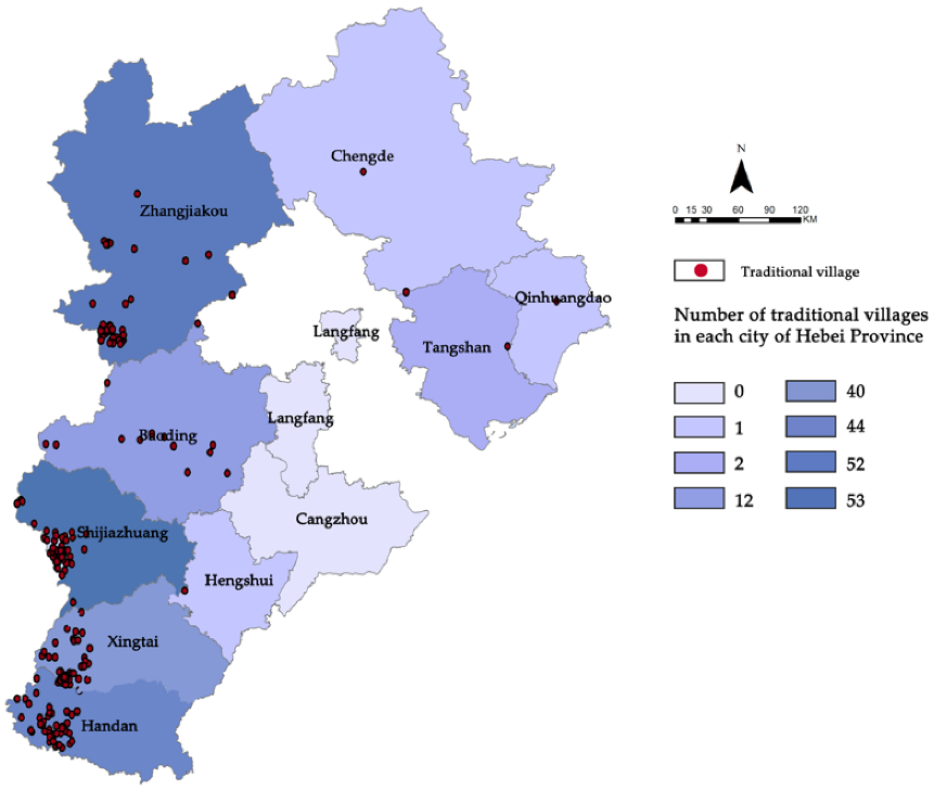
Figure 1. GIS in the distribution of traditional villages in Hebei, China in 2022(Source: mdpi.com)
2.2. Traffic Flow and Accessibility
GIS technology plays a pivotal role in the analysis and management of traffic flow and urban accessibility. By integrating data from various sources, such as traffic sensors, GPS tracking, and transport models, GIS provides a comprehensive view of current traffic patterns and potential bottlenecks. This integration enables urban planners to simulate various traffic scenarios, including peak hour flows, the impact of road closures, and the effectiveness of traffic diversion strategies. For example, GIS can be used to analyze the impact of a new public transportation route on local traffic conditions, helping planners optimize routes and stops for maximum efficiency and accessibility. The technology also supports the planning of pedestrian-friendly spaces by analyzing foot traffic patterns and identifying areas that require improved pedestrian infrastructure, such as sidewalks, crossings, and public squares. Additionally, GIS tools aid in designing cycling networks by identifying the most suitable routes that ensure safety and connectivity for cyclists [3]. By providing a data-driven approach to traffic management, GIS helps in creating urban spaces that prioritize accessibility and minimize congestion, enhancing the overall quality of urban life.
2.3. Environmental Impact Assessments
In conducting environmental impact assessments (EIAs), GIS emerges as an indispensable tool, providing a robust framework for analyzing and visualizing the environmental consequences of architectural projects. Through GIS, planners can integrate various environmental datasets, such as soil quality, water resources, vegetation cover, and wildlife habitats, to assess the potential impacts of construction projects on the local ecosystem. This analysis is crucial for identifying and mitigating adverse effects on biodiversity, water quality, and natural habitats. GIS-enabled shadow studies are another significant aspect of EIAs, allowing for the assessment of how new structures will cast shadows throughout the day and across seasons, thereby understanding their impact on neighboring buildings and public spaces in terms of light access and thermal comfort. Wind flow analysis through GIS helps in evaluating how new constructions will alter local wind patterns, which is essential for ensuring ventilation in urban areas and assessing potential impacts on microclimates. Table 1 summarizes the use of GIS in environmental and assessment [4]. Furthermore, GIS is instrumental in noise pollution modeling, enabling planners to map noise levels and identify areas where mitigation measures, such as sound barriers or building insulation, are necessary. By providing a comprehensive and integrated approach to environmental assessment, GIS ensures that architectural and urban planning projects are developed with a minimal ecological footprint and in harmony with the natural environment.
Table 1. GIS Applications in Environmental and Assessments
GIS Application | Purpose | Impact on Urban Planning |
Environmental Datasets Integration | Assess impacts of construction on local ecosystem, including soil quality, water resources, vegetation, and wildlife habitats. | Identifies and mitigates adverse effects on biodiversity, water quality, and natural habitats. |
Shadow Studies | Analyze how new structures will cast shadows, affecting light access and thermal comfort in neighboring buildings and public spaces. | Ensures balanced light access and thermal comfort, enhancing living conditions in urban areas. |
Wind Flow Analysis | Evaluate alterations in local wind patterns due to new constructions, crucial for urban ventilation and microclimate assessment. | Assists in maintaining adequate ventilation and assessing impacts on local microclimates. |
Noise Pollution Modeling | Map noise levels and identify areas requiring mitigation measures like sound barriers or building insulation. | Aids in creating quieter, more comfortable urban environments through effective noise management. |
3. GIS in Infrastructure and Utility Management
3.1. Urban Infrastructure Planning
The utilization of GIS in urban infrastructure planning transcends conventional approaches, offering a data-driven and analytical perspective. For instance, in transportation network design, GIS facilitates the integration of various data layers, including population density, existing road networks, and land use patterns. This integration allows planners to identify areas with high traffic demand and plan road expansions or public transportation routes accordingly. In the case of sewage systems, GIS helps in mapping the topography and existing infrastructure, which is crucial for designing gravity-based drainage systems and minimizing the need for pumping stations. Furthermore, GIS plays a vital role in electricity grid management [5]. It enables utility companies to overlay electrical grid maps with urban growth projections, allowing for the anticipation of increased demand and planning for grid expansion or upgrades. By providing a holistic view of the urban fabric, GIS ensures that infrastructure planning is not only efficient but also sustainable, taking into account future growth and environmental impacts.
3.2. Disaster Management and Response
In the realm of disaster management, the application of GIS is transformative, particularly in risk assessment and emergency response. GIS enables the analysis of geographic data related to natural hazards such as flood zones, earthquake fault lines, and areas prone to wildfires. By overlaying this data with population density maps and infrastructure layouts, planners can identify high-risk areas and prioritize resource allocation for emergency preparedness. During disaster response, GIS becomes a critical tool for coordination. Real-time GIS data can track the progression of a disaster, such as the spread of a wildfire or the path of a hurricane, enabling timely evacuation orders and resource deployment. Additionally, post-disaster, GIS assists in damage assessment by comparing pre and post-event satellite imagery, thereby facilitating a targeted and efficient recovery process. This application of GIS not only minimizes the impact of disasters but also enhances the resilience of communities against future events.
3.3. Historical and Cultural Preservation
GIS’s role in historical and cultural preservation is increasingly recognized as an essential tool for conservators and urban planners. By creating detailed spatial databases of historical sites, GIS enables the analysis of factors such as urban encroachment, environmental threats, and the impact of tourism. For example, GIS can be used to monitor the structural integrity of historical buildings by integrating data from ground-penetrating radar and laser scanning. This technology aids in identifying areas of a structure that are at risk of deterioration, allowing for timely restoration efforts. Additionally, GIS facilitates the planning of buffer zones around heritage sites, ensuring that new development does not adversely affect these landmarks. In urban contexts, where historical sites are often surrounded by modern infrastructure, GIS assists in reconciling the needs of preservation with urban development. By providing detailed spatial information, GIS empowers planners and conservationists to make decisions that respect the historical and cultural significance of these sites while accommodating the needs of a growing city [6].
4. Challenges in Implementing GIS in Urban Planning
4.1. Data Accuracy and Reliability
Ensuring the accuracy and reliability of spatial data is paramount in GIS applications for urban planning. Inaccurate data can lead to suboptimal decision-making and potentially costly mistakes in project execution. The primary sources of data inaccuracy stem from outdated information, errors in data collection, and the inherent limitations of spatial resolution in GIS datasets. For instance, outdated aerial imagery may not accurately reflect current land-use patterns, leading to erroneous zoning decisions. Similarly, errors in data collection, whether from field surveys or automated sensors, can propagate through the planning process, resulting in flawed urban designs. The challenge is further compounded by the varying spatial resolutions of GIS data, which can limit the detail and granularity available for analysis, particularly in complex urban environments. To mitigate these risks, urban planners must employ rigorous data validation and verification processes, incorporating cross-referencing techniques and continuously updating GIS datasets with the latest available information.
4.2. Interoperability and Integration
Interoperability between different GIS platforms and their integration with other urban planning tools is a significant technical hurdle. Urban planning involves various stakeholders, each potentially using different GIS software and data formats. This diversity can lead to compatibility issues, hindering the seamless exchange of data and collaboration. For example, a GIS system used by a municipal planning department may not be compatible with the software used by a transportation agency, complicating efforts to coordinate urban infrastructure projects [7]. Similarly, the integration of GIS with Building Information Modeling (BIM) systems, which is crucial for detailed architectural planning, often faces challenges due to differences in data structures and standards, as shown in Figure 2. Addressing these issues requires the adoption of common data standards and protocols, along with the development of middleware and translation tools that facilitate data exchange and integration across diverse platforms. Additionally, fostering collaborations and partnerships among software developers, urban planners, and architects is essential to enhance the interoperability of GIS tools in urban planning.
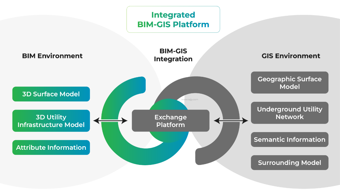
Figure 2. BIM and GIS Integration Applications & Benefitsn (Source: tejjy.com)
5. The Future of GIS in Urban Development
5.1. Technological Advancements
The future of Geographic Information Systems (GIS) in urban planning and architecture is inextricably linked to the continuous evolution of technology, particularly the advances in Artificial Intelligence (AI) and machine learning. AI and machine learning algorithms can significantly augment the capabilities of GIS by enabling more sophisticated spatial analysis and predictive modeling. For instance, AI can be employed to automatically analyze vast amounts of geographic data, identifying patterns and trends that would be imperceptible to human analysts. This can lead to more accurate predictions about urban growth, traffic patterns, and environmental impacts. Machine learning, on the other hand, can be used to improve the accuracy of GIS tools by constantly refining algorithms based on new data. This continuous learning process can be instrumental in areas such as predictive maintenance of urban infrastructure, where machine learning models can analyze historical data to predict future failures or maintenance needs. The integration of AI and machine learning with GIS will also facilitate the development of more intuitive and user-friendly interfaces, making GIS tools more accessible to planners and architects without specialized training.
5.2. Integration with Smart City Concepts
GIS is poised to play a central role in the development and functioning of smart cities. The integration of GIS with Internet of Things (IoT) and other smart technologies will be pivotal in creating an interconnected urban ecosystem. For example, when combined with IoT devices, GIS can provide real-time data on various urban parameters such as traffic flow, air quality, and energy consumption. This data can then be used to optimize traffic signals, plan efficient public transportation routes, and manage energy distribution more effectively. Furthermore, GIS can assist in spatial planning for the installation of IoT sensors and devices, ensuring optimal coverage and data collection. Smart city initiatives also involve the creation of digital twins - virtual models of physical cities. GIS is crucial in building these models, providing the spatial framework on which other data layers are overlaid. This integration facilitates scenario planning and impact analysis, allowing city planners to simulate and evaluate the effects of different urban development strategies.
6. Conclusion
In conclusion, Geographic Information Systems (GIS) have emerged as indispensable tools in urban planning and architecture, offering unparalleled insights and capabilities in spatial analysis and decision-making. From shaping urban layouts to managing environmental impacts, GIS applications have profoundly influenced contemporary urban planning practices. However, the implementation of GIS is not without challenges, requiring accurate data, interoperability among various systems, and ongoing skill development. Looking forward, the integration of GIS with emerging technologies like AI and the Internet of Things, aligned with supportive policy frameworks, will further enhance its role in developing smart, sustainable cities. This paper reaffirms the vital role of GIS in urban planning, emphasizing its potential to shape future urban landscapes while addressing modern-day challenges.
References
[1]. Supriadi, Andri, and Teddy Oswari. “Analysis of Geographical Information System (GIS) design aplication in the Fire Department of Depok City.” Technium Soc. Sci. J. 8 (2020): 1.
[2]. Tomaszewski, Brian. Geographic information systems (GIS) for disaster management. Routledge, 2020.
[3]. Mandel, Lauren Heather, Bradley Wade Bishop, and Ashley Marie Orehek. “A new decade of uses for geographic information systems (GIS) as a tool to research, measure and analyze library services.” Library Hi Tech 41.4 (2023): 1022-1038.
[4]. Adimalla, Narsimha, and Ajay Kumar Taloor. “Hydrogeochemical investigation of groundwater quality in the hard rock terrain of South India using Geographic Information System (GIS) and groundwater quality index (GWQI) techniques.” Groundwater for Sustainable Development 10 (2020): 100288.
[5]. Ogato, Gemechu Shale, et al. “Geographic information system (GIS)-Based multicriteria analysis of flooding hazard and risk in Ambo Town and its watershed, West shoa zone, oromia regional State, Ethiopia.” Journal of Hydrology: Regional Studies 27 (2020): 100659.
[6]. Bashir, Nusrat, et al. “Water quality assessment of lower Jhelum canal in Pakistan by using geographic information system (GIS).” Groundwater for sustainable development 10 (2020): 100357.
[7]. Aykut, Tunahan. “Determination of groundwater potential zones using geographical information systems (GIS) and analytic hierarchy process (AHP) between Edirne-Kalkansogut (northwestern Turkey).” Groundwater for Sustainable Development 12 (2021): 100545.
Cite this article
Chen,L.;Li,J.;Xu,M.;Xing,W. (2024). Navigating urban complexity: The role of GIS in spatial planning and urban development. Applied and Computational Engineering,65,282-287.
Data availability
The datasets used and/or analyzed during the current study will be available from the authors upon reasonable request.
Disclaimer/Publisher's Note
The statements, opinions and data contained in all publications are solely those of the individual author(s) and contributor(s) and not of EWA Publishing and/or the editor(s). EWA Publishing and/or the editor(s) disclaim responsibility for any injury to people or property resulting from any ideas, methods, instructions or products referred to in the content.
About volume
Volume title: Proceedings of Urban Intelligence: Machine Learning in Smart City Solutions - CONFSEML 2024
© 2024 by the author(s). Licensee EWA Publishing, Oxford, UK. This article is an open access article distributed under the terms and
conditions of the Creative Commons Attribution (CC BY) license. Authors who
publish this series agree to the following terms:
1. Authors retain copyright and grant the series right of first publication with the work simultaneously licensed under a Creative Commons
Attribution License that allows others to share the work with an acknowledgment of the work's authorship and initial publication in this
series.
2. Authors are able to enter into separate, additional contractual arrangements for the non-exclusive distribution of the series's published
version of the work (e.g., post it to an institutional repository or publish it in a book), with an acknowledgment of its initial
publication in this series.
3. Authors are permitted and encouraged to post their work online (e.g., in institutional repositories or on their website) prior to and
during the submission process, as it can lead to productive exchanges, as well as earlier and greater citation of published work (See
Open access policy for details).
References
[1]. Supriadi, Andri, and Teddy Oswari. “Analysis of Geographical Information System (GIS) design aplication in the Fire Department of Depok City.” Technium Soc. Sci. J. 8 (2020): 1.
[2]. Tomaszewski, Brian. Geographic information systems (GIS) for disaster management. Routledge, 2020.
[3]. Mandel, Lauren Heather, Bradley Wade Bishop, and Ashley Marie Orehek. “A new decade of uses for geographic information systems (GIS) as a tool to research, measure and analyze library services.” Library Hi Tech 41.4 (2023): 1022-1038.
[4]. Adimalla, Narsimha, and Ajay Kumar Taloor. “Hydrogeochemical investigation of groundwater quality in the hard rock terrain of South India using Geographic Information System (GIS) and groundwater quality index (GWQI) techniques.” Groundwater for Sustainable Development 10 (2020): 100288.
[5]. Ogato, Gemechu Shale, et al. “Geographic information system (GIS)-Based multicriteria analysis of flooding hazard and risk in Ambo Town and its watershed, West shoa zone, oromia regional State, Ethiopia.” Journal of Hydrology: Regional Studies 27 (2020): 100659.
[6]. Bashir, Nusrat, et al. “Water quality assessment of lower Jhelum canal in Pakistan by using geographic information system (GIS).” Groundwater for sustainable development 10 (2020): 100357.
[7]. Aykut, Tunahan. “Determination of groundwater potential zones using geographical information systems (GIS) and analytic hierarchy process (AHP) between Edirne-Kalkansogut (northwestern Turkey).” Groundwater for Sustainable Development 12 (2021): 100545.