


1. Introduction
Transport is an important infrastructure for cities, it defines the access of these city dwellers to wealth and well-being [1], and information modeling can help people analyze existing traffic quickly. With the development of building information modeling, the rapid establishment of a city’s information model has become increasingly important, while most of the existing research in China focuses on the specific analysis of a region and lacks the analysis of the most suitable urban traffic layout for each terrain. Although these methods can carry out a detailed and accurate analysis, they are time-consuming and inefficient, not conducive to the rapid establishment of the building model, and also difficult to match the use of a large scale.
In this paper, we will analyze and compare existing urban layout plans to select the better urban layout for the plain regions. Section 2 shows the impact of the plains on the transport layout. Section 3 demonstrates the analysis of existing urban layouts in China. Section 4 presents the choice of the most suitable transport layout for the plain areas.
The purpose of this paper is to help readers build a city model in the plains rapidly when constructing information models. Also, it can fill in the lack of domestic research on the general urban traffic layout analysis of a specific terrain. In addition, this research also allows for the rebuilding of severely damaged cities in a short time and the return to the normal operation of urban traffic.
2. The impact of the plains on traffic layout
2.1. The topography of China’s major plains and their climatic varieties
2.1.1. Northeast China Plain. The Northeast China Plain can be divided into three parts, the Songnen Plain in the north, the Liao River Plain in the south, and the Songliao Watershed in the middle. The overall terrain is relatively flat and there are many swamps and wetlands. Drainage is inconvenient here [2].
Besides, it is in the temperate and warm-temperate ranges and is characterized by continental and monsoon-type climates. Summers are short and warm with lots of rain, winters are long, cold, and lack snow while the monsoon alternates between winter and summer. In addition, low temperatures in spring and frosts in autumn are frequent. The banks of rivers and depressions are often flooded during the flood season [2].
2.1.2. North China Plain. The North China Plain is flat, with many lakes and rivers, and is a contiguous Great Plain [3].
Most of the region has a warm, temperate, semi-humid climate, with little rain and drought in winter and spring and rainy and humid in summer. Furthermore, it has frequent drought and flood disasters [3].
2.1.3. Yangtze Plain, Middle and Lower. The Yangtze Plain, Middle and Lower consists of the Dongting-Jianghan Plain, the Poyang Lake Plain, the Jiangsu and Anhui Plain along the Yangtze River, the Plain between Li and Xia River and the Yangtze River Delta Plain, with low terrain and a dense water network [4].
As for the climatic characteristics, it has a favorable climate, a relatively even seasonal distribution, and moderate precipitation, but will experience drought in the summer months [4].
2.2. Influence of regional topography and climate on transportation layout
We divide the transportation layout into rail (including high-speed rail and subway) and road transportation (i.e., bus routes and private car routes), each of them will be discussed.
2.2.1. Rail transportation. Due to technical, economic, or social factors, the laying of railroads will be constrained by the topography of the terrain. Routes are generally laid along gently sloping areas, which means that engineers need to consider the slope and curvature of the terrain to avoid disrupting the surrounding populations during the construction process, and routes requiring bridges and tunnels need to be chosen as little as possible since they are expensive.
Moreover, when a train travels on a hill, it needs to overcome the greater resistance caused by the gradient, which leads to a reduction in operating speed and an increase in travel time, which affects passenger comfort and reduces traffic flow, while the vehicle also needs more power to travel on the road, that means an increase in operating and maintenance costs.
2.2.2. Road transportation. Special topography can make the city densely built up and the roads available for access can become narrower, which can constrain road design, and arterial roads with high volumes of traffic need to avoid these neighborhoods. Furthermore, narrow roads may cause some safety hazards. The need for a vehicle to change lanes when going from a wide road to a narrow road may cause it to collide with vehicles already in the roadway. Cars on a narrow route will have less clearance, which also leads to more accidents.
The road system, topography, and other barriers also affect the location and spacing of public transport stopping places. Closer spacing of bus stops is required in steeper areas or areas with topographic barriers to prevent splitting impacts and ensure coverage [5]. This requirement increases dwell time and reduces overall operating speeds, passengers may be upset by this.
3. Case studies on urban design
3.1. Grid City
The grid city means the whole city will be divided into small square shapes, and buildings will be placed in these squares. Many cities in the United States have adopted this design, such as Washington, D.C., New York, and San Francisco.
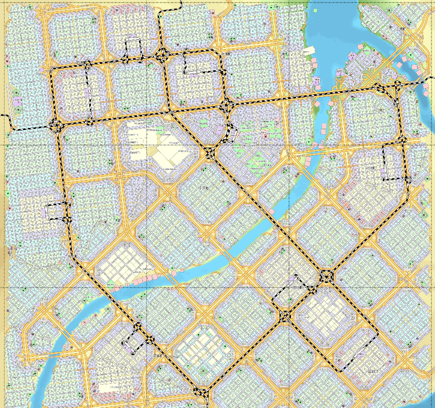
Figure 1. A model of the grid city [6].
Figure 1 shows a typical grid city model where buildings are densely packed together and the city is connected through main roads.
Although this design approach makes urban design easy and convenient, it is more constrained by topography. It can be easily blocked by irregular terrain such as valleys, rivers, and rocks, which create intermittent paths. These kinds of terrains are often difficult to destroy, or the costs involved in destroying them are significantly high. Also, dense construction narrows the access roads, and transportation for those residents who are far from the main roads can become extremely inconvenient. Moreover, dense traffic lights slow down the flow of traffic, causing congestion in the city.
3.2. Linear City
The linear city means the urban development relies on transportation lines extending in bands, the city should have a wide road as a spine, there should be a limit to the width of the city, but the length can be unlimited, and buildings are constructed along the sides of the roads [7].
This urban model is less affected by the terrain since the shape of the city can change with the terrain, making it adaptable to all types of terrain. However, ‘‘low connectivity of the urban body due to the lack of high-speed modes and highways. The so-called high-speed tram cannot replace rail types of high-speed transport with those really needed by the city [8].’’ In addition, since the width of the city is fixed and its length is always extending, as the population grows, the connectivity of the city will be drastically reduced, and people located at the two ends of the city will have difficulties reaching the center of the city, which is very inconvenient for the citizens’ life.
On the other hand, the diversity of design models and scales suggests that transit route-based development has a general potential to leverage and prioritize the proximity of public transportation and to address sustainability challenges such as urban sprawl, automobile dependence, pollution, social inequality, lack of urban health, and disconnection from the natural environment [9]. There is no doubt that this design brings citizens closer to public transportation, their short trips will be more convenient, and because most of the vehicles are traveling on one main road, there will be fewer diversions, which means less congestion.
3.3. Garden City
This design concept was first proposed by the British urban planner Ebenezer Howard in his book “Garden Cities of To-morrow” in 1898. This urban structure is like a spider’s web, expanding outward from the center and forming a series of concentric circles, dividing the city into functional zones, with the city surrounded by green belts.
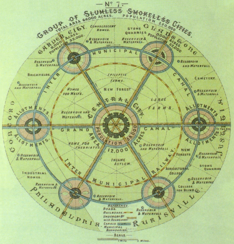
Figure 2. The theoretical model of a garden city [10].
According to Figure 2, it can be seen that many small cities were connected by railroads to form a large city.
The biggest advantage of a garden city is sustainability. This type of city has very little impact on the environment and the abundance of greenery makes it eco-friendly [11]. It focuses more on public transportation than private cars, which effectively reduces traffic jams, and this produces a lower carbon footprint.
However, too much space in the city is used for greenery, which results in it not being able to accommodate population growth. There is not enough space in the city to build extra housing. This situation results in an increase in house prices and many people will be displaced due to the unaffordable house prices. In conclusion, this type of urban design is too idealistic and does not cater to the growth of the population.
4. Selection of urban transportation layouts suitable for cities in the plains
From section 2.1, we can find that most of China’s plains are at risk of flooding. To solve this issue, the transportation layout needs to have a good drainage system. Also, China has the largest population in the world and most people do not have high incomes, so city managers have to control the price of land to cope with the demand for housing. In order to do this, buildings must be densely packed to keep prices down and to accommodate enough residents.
Additionally, the traffic problems associated with a high population are noteworthy as well. Residents of large cities will expect public transport to be fast, efficient, affordable, safe, and environmentally friendly [12]. To face this requirement, city designers should pay more attention to public transportation, which can improve health and health equity by reducing traffic accidents and air pollution, increasing physical activity, and improving access to health care, healthy food, vital services, employment, and social connections [13]. Public transport can significantly reduce car use, thereby reducing traffic accidents and environmental pollution. At the same time, public transport is more convenient and quicker than private modes of travel, as the use of public transport reduces traffic flow, making traffic jams almost impossible to occur.
Despite linear city and garden city’s respective shortcomings, they still have some things to offer. The theory of the linear city states that cities develop along transport routes, which makes it easier to get around even though the connectivity of the city suffers, we can modify this theory to say that transport routes develop along the city since the transport routes should serve the city. The advantage of the linear city is that it essentially brings the citizens closer to the transport hubs, so we just need to use this point in the design. In terms of the garden city, this type of outward urban expansion is worthwhile. The only problem is that it is a waste of space, but green areas can be converted into residential areas; in this way, the advantages of garden cities in favor of public transport can be preserved without wasting space. Meanwhile, the structure of a garden city is also more conducive to the functional zoning of the city due to the cobweb-like structure that divides the city into smaller parts.
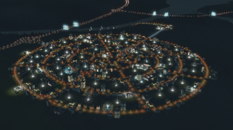
Figure 3. An architectural model of a garden city
The city is made up of concentric circles, which are connected by several main roads. Public transport and drainage systems can be laid directly along the road, allowing for quick and easy design as well as ensuring their practicality. Citizens have access to public transport as soon as they leave their homes and can quickly reach any part of the city through a network of transport links throughout the city. The city government is located at the center of the city so that it can radiate its dominance throughout the city, and each area of the city should be equipped with functional buildings, such as hospitals, police stations, fire stations, and schools, to meet the needs of the residents of the area, and buildings that radiate over a large area can be equipped with one for multiple areas. Obviously, the closer you are to the center, the better the city services are. Comparatively, the price of land is highest in the center and decreases outwards, so people can choose the area to live in according to their own needs and financial ability. The area outside the city limits is used for buildings that cause pollution or need to be kept away from people, for example, factories, rubbish dumps, cemeteries, etc. This will go a long way in preventing them from affecting the normal life of the inhabitants while keeping them at the service of the city. Most importantly, urban designers can choose the number of concentric circles and main roads according to the needs of the city’s population development. The number of concentric circles corresponds to the number of people that the city can accommodate, while the number of main roads corresponds to the accessibility of the traffic in the city.
5. Conclusion
By analyzing the existing plains in China and several urban design concepts, the grid city can solve the problem of population development and simplify the design. The only disadvantage of this type of urban design is that it is not adapted to the topography of the undulating terrain, but in the plains, this is not a serious problem. When modeling a city, the designer can simply apply this design, which is applicable to most situations, and this will greatly save time throughout the design process. Similarly, when rebuilding a city, this design can help people get back to the basics in a short time.
However, if there are only a few small rivers in the city then this does not pose a problem, whereas when the city needs to cross larger rivers this design can be problematic, with concentric circles being cut off by the river, leading to a discontinuous city. Also, this design does not take into account the human impact on the city, the comfort level of the citizens in this city is not yet known, people may not like the shape or it may make them uncomfortable to drive on a circular road for a long period of time. In future work, perhaps questionnaires or modeling will be used to address this issue.
References
[1]. Tsay, S. P., & Herrmann, V. (2013). Rethinking urban mobility: sustainable policies for the century of the city (pp. 68-p). Washington, DC, USA: Carnegie Endowment for International Peace.
[2]. Institute of Geographic Sciences and Natural Resources Research, CAS. (2007) Northeast China Plain. http://www.igsnrr.cas.cn/cbkx/kpyd/zgdl/cndm/202009/t20200910_5692361.html
[3]. Institute of Geographic Sciences and Natural Resources Research, CAS. (2007) North China Plain. http://www.igsnrr.cas.cn/cbkx/kpyd/zgdl/cndm/202009/t20200910_5692360.html
[4]. Institute of Geographic Sciences and Natural Resources Research, CAS. (2007) Yangtze Plain, Middle and Lower. http://www.igsnrr.cas.cn/cbkx/kpyd/zgdl/cndm/202009/ t20200910_ 5692359.html
[5]. Daniels, R., & Mulley, C. (2012). Planning public transport networks—the neglected influence of topography. Journal of Public Transportation, 15(4), 23-41.
[6]. Msoeg. (2022) No one knows Plaid City better than I do. https://zhuanlan.zhihu.com/p/541709663
[7]. Luo X, W. (2004) History of Modern and Contemporary Foreign Architecture. China Architecture & Building Press. Beijing.
[8]. Antyufeev, A. V., & Antyufeeva, O. A. (2019, December). Linear cities: controversies, challenges and prospects. In IOP Conference Series: Materials Science and Engineering (Vol. 687, No. 5, p. 055025). IOP Publishing.
[9]. Tufek-Memisevic, T. (2023, June). Understanding the Linear City.(Mis) interpretation, Categorization, and Realization. In International Symposium on Annual Days of BHAAAS in Bosnia and Herzegovina (pp. 73-96). Cham: Springer Nature Switzerland.
[10]. Susanna Moreira. (2021) What Are Garden Cities? What Are Garden Cities? | ArchDaily
[11]. Marlena Angermann. (2023) Garden City Movement: History, Examples and Criticism. Garden City Movement: History, Examples and Criticism - Utopia
[12]. Intelligent Transport. (2021) Population growth and public transport: what is the future of ridership? Population growth and public transport. What is the future of ridership? (intelligenttransport.com)
[13]. Wendy Heaps, Erin Abramsohn, Elizabeth Skillen. (2021) Public Transportation In The US: A Driver Of Health And Equity. Public Transportation In The US: A Driver Of Health And Equity | Health Affairs
Cite this article
Deng,R. (2024). Analyzing the urban transport layout in the plains of China. Applied and Computational Engineering,66,1-7.
Data availability
The datasets used and/or analyzed during the current study will be available from the authors upon reasonable request.
Disclaimer/Publisher's Note
The statements, opinions and data contained in all publications are solely those of the individual author(s) and contributor(s) and not of EWA Publishing and/or the editor(s). EWA Publishing and/or the editor(s) disclaim responsibility for any injury to people or property resulting from any ideas, methods, instructions or products referred to in the content.
About volume
Volume title: Proceedings of the 2nd International Conference on Functional Materials and Civil Engineering
© 2024 by the author(s). Licensee EWA Publishing, Oxford, UK. This article is an open access article distributed under the terms and
conditions of the Creative Commons Attribution (CC BY) license. Authors who
publish this series agree to the following terms:
1. Authors retain copyright and grant the series right of first publication with the work simultaneously licensed under a Creative Commons
Attribution License that allows others to share the work with an acknowledgment of the work's authorship and initial publication in this
series.
2. Authors are able to enter into separate, additional contractual arrangements for the non-exclusive distribution of the series's published
version of the work (e.g., post it to an institutional repository or publish it in a book), with an acknowledgment of its initial
publication in this series.
3. Authors are permitted and encouraged to post their work online (e.g., in institutional repositories or on their website) prior to and
during the submission process, as it can lead to productive exchanges, as well as earlier and greater citation of published work (See
Open access policy for details).
References
[1]. Tsay, S. P., & Herrmann, V. (2013). Rethinking urban mobility: sustainable policies for the century of the city (pp. 68-p). Washington, DC, USA: Carnegie Endowment for International Peace.
[2]. Institute of Geographic Sciences and Natural Resources Research, CAS. (2007) Northeast China Plain. http://www.igsnrr.cas.cn/cbkx/kpyd/zgdl/cndm/202009/t20200910_5692361.html
[3]. Institute of Geographic Sciences and Natural Resources Research, CAS. (2007) North China Plain. http://www.igsnrr.cas.cn/cbkx/kpyd/zgdl/cndm/202009/t20200910_5692360.html
[4]. Institute of Geographic Sciences and Natural Resources Research, CAS. (2007) Yangtze Plain, Middle and Lower. http://www.igsnrr.cas.cn/cbkx/kpyd/zgdl/cndm/202009/ t20200910_ 5692359.html
[5]. Daniels, R., & Mulley, C. (2012). Planning public transport networks—the neglected influence of topography. Journal of Public Transportation, 15(4), 23-41.
[6]. Msoeg. (2022) No one knows Plaid City better than I do. https://zhuanlan.zhihu.com/p/541709663
[7]. Luo X, W. (2004) History of Modern and Contemporary Foreign Architecture. China Architecture & Building Press. Beijing.
[8]. Antyufeev, A. V., & Antyufeeva, O. A. (2019, December). Linear cities: controversies, challenges and prospects. In IOP Conference Series: Materials Science and Engineering (Vol. 687, No. 5, p. 055025). IOP Publishing.
[9]. Tufek-Memisevic, T. (2023, June). Understanding the Linear City.(Mis) interpretation, Categorization, and Realization. In International Symposium on Annual Days of BHAAAS in Bosnia and Herzegovina (pp. 73-96). Cham: Springer Nature Switzerland.
[10]. Susanna Moreira. (2021) What Are Garden Cities? What Are Garden Cities? | ArchDaily
[11]. Marlena Angermann. (2023) Garden City Movement: History, Examples and Criticism. Garden City Movement: History, Examples and Criticism - Utopia
[12]. Intelligent Transport. (2021) Population growth and public transport: what is the future of ridership? Population growth and public transport. What is the future of ridership? (intelligenttransport.com)
[13]. Wendy Heaps, Erin Abramsohn, Elizabeth Skillen. (2021) Public Transportation In The US: A Driver Of Health And Equity. Public Transportation In The US: A Driver Of Health And Equity | Health Affairs