


1. Introduction
Drone is a remote-controlled or autonomous flight system equipped with sensors and cameras, which can complete various tasks; while artificial intelligence is a technology that simulates human intelligence and can achieve autonomous decision-making and learning through algorithms. When drones and AI are integrated, drones can collect a large amount of data by carrying various sensors and cameras, and AI technology can analyze and process this data to achieve more applications.
The rapid advancement of technology has significantly influenced various sectors, and the field of drones is one such area that has seen remarkable progress. Drones, also known as unmanned aerial vehicles (UAV), have evolved from simple remote-controlled aircraft to sophisticated machines capable of performing complex tasks. Central to this evolution is the integration of Artificial Intelligence (AI), which has transformed drones into intelligent and autonomous systems.
Pattern recognition technology for drones is an important area of research. Currently, the core of object recognition is based on distinguishable features. Advanced algorithms and machine learning techniques are employed to detect and classify objects by their identifiable characteristics. These methods involve analyzing images to extract features using convolutional neural networks (CNNs) and other deep learning models. This approach allows drones to recognize patterns and features with high precision, enhancing their ability to navigate complex environments and adapt to dynamic conditions. By leveraging these technologies, drones can effectively analyze spontaneous events and terrain changes, resulting in the creation of accurate and appropriate site plans.
AI algorithms enable drones to process real-time data, make decisions, and adapt to dynamic environments without human intervention. This capability is particularly beneficial in SAR operations, where time is critical, and accessing remote or hazardous areas can be challenging. The combination of AI and drones offers numerous advantages, such as improved situational awareness, faster response times, and increased mission success rates [1].
In addition, the combination of drones and AI can also build a complete monitoring system. At the same time, drones can also be equipped with various sensors to detect and collect parameters, and then analyze and process them through AI algorithms to provide decision makers with accurate and reliable monitoring data. The primary motivation behind this paper is to explore the transformative potential of integrating AI with drone technology across various fields. By analyzing these areas, the paper contributes to the field by exploring the integration of AI in drone technology, focusing on significant advancements and practical applications. It examines how AI enhances autonomous navigation, optimizes package delivery systems, improves warehouse inventory management, and supports disaster response efforts. By analyzing these areas, the paper demonstrates the transformative potential of AI in enhancing the efficiency and capabilities of drones.
2. Autonomous Navigation and Target Tracking
2.1. Automated Package Delivery Systems
With the booming development of e-commerce and the increasing demand of consumers for faster delivery, traditional delivery methods are no longer sufficient to meet customer expectations. Drones have gradually become a highly anticipated delivery tool with advantages such as high efficiency, low cost, environmental protection and flexibility. For example, companies such as JD.com and SF Express have launched drone logistics pilot projects in rural areas, which greatly reduced delivery costs and time through drone delivery.
JD.com reported a reduction in delivery costs by up to 70% in some rural areas, while delivery times were cut from several hours to just 20-30 minutes. Similarly, SF Express has seen a 50% improvement in delivery efficiency in their pilot projects. Specifically, drones can optimize delivery routes, avoid obstacles, and land accurately at designated locations, thereby improving delivery efficiency and accuracy (Figure 1) [2,3]

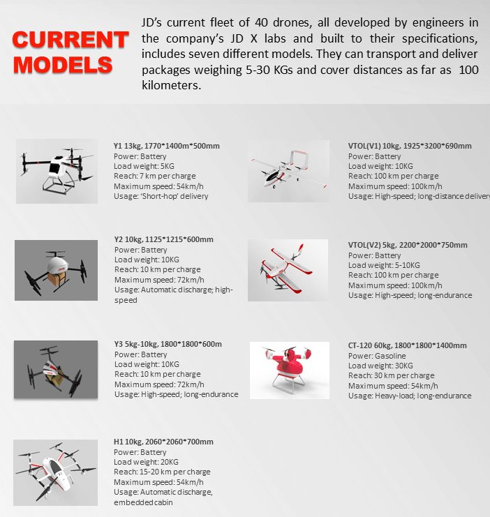
Figure 1. Current Models of JD [2]
2.2. Inventory Management in Warehouses
2.2.1. Inventory Tracking Traditional manual inventory management is labor-intensive and prone to errors. AI automation technologies like Robotic Process Automation (RPA) and sensor shelves enable real-time inventory updates, improving accuracy and transparency. The integration of CNN and Transformer-based object detection algorithms can significantly enhance the performance of inventory management systems [4].
Recent research proposed a drone image object detection algorithm combining CNN and Transformer to address issues such as dense targets, complex backgrounds, and difficulties in detecting small targets in drone images. This algorithm builds upon the YOLOv5 network by integrating the Transformer structure, which overcomes the limitations of CNN's receptive field through the self-attention mechanism to capture global dependencies. Additionally, it employs a large-scale feature map and a weighted bidirectional feature pyramid network (BiFPN) to enhance feature propagation and reuse, significantly improving the network's ability to detect small targets. Furthermore, the use of dimensionality reduction and sliding window methods reduces memory consumption and computational load, making the algorithm more efficient.
For instance, the application of this advanced detection algorithm in a warehouse setting allows for the precise tracking of inventory items. The CNN and Transformer-based approach can accurately detect the location and quantity of items stored on shelves, ensuring real-time inventory data is always accurate (Figure 2). This reduces the likelihood of overstocking and stockouts, optimizing inventory levels and improving overall warehouse efficiency [5].
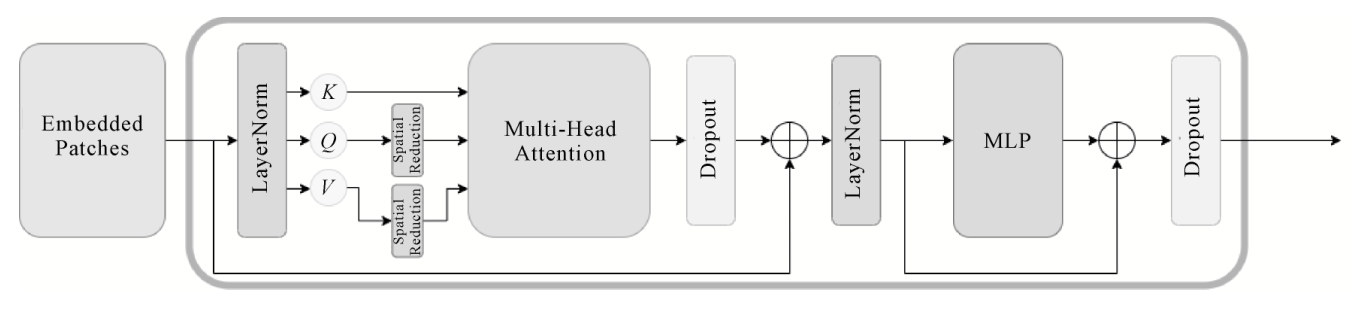
Figure 2. The Structure of the modules of Transformer [5]
2.2.2. Order Fulfillment AI systems significantly enhance order picking efficiency by optimizing routes and batch orders. Machine learning algorithms analyze order data to determine the optimal picking sequence, reducing incomplete orders and process bottlenecks. The advanced object detection algorithm combining CNN and Transformer improves detection accuracy in complex environments.
Table 1 shows the performance of different modifications on the VisDrone2021 validation set. These results highlight the impact of integrating Transformer modules and BiFPN structures on improving detection accuracy and processing capabilities. By embedding lightweight Transformer modules within the network, the algorithm captures extensive contextual information, addressing issues such as varying target sizes, occlusions, and complex backgrounds. The BiFPN structure allows effective feature fusion from different layers, enhancing the detection of small and densely packed objects. Additionally, advanced image augmentation techniques like MixUp and Mosaic create enriched training samples, boosting the model's robustness and accuracy.
Table 1. The performance of different modifications
Method | mAP/% | \( {AP_{50}} \) /% |
YOLOv5 | 35.71 | 57.23 |
YOLOv5+TTA | 36.72 | 59.05 |
YOLOv5+TTA+P2 | 38.74 | 61.28 |
YOLOv5+TTA+P2+BiFPN | 40.26 | 62.24 |
YOLOv5+TTA+P2+BiFPN+Transformer | 42.52 | 64.63 |
In a warehouse environment, these advancements optimize the order picking process by accurately detecting and identifying item locations on shelves. This enables dynamic adjustment of picking routes and prioritization of tasks based on real-time inventory data, significantly improving order fulfillment efficiency.
2.3. Disaster Response and Emergency Services
2.3.1. Search and Rescue Operations Autonomous drones equipped with deep learning algorithms for image processing and dynamic flight-path adaptation can effectively locate individuals in dense environments such as forests. These drones use real-time onboard computation to enhance search efficiency and reduce data transmission needs.
UAVs integrated with high-precision sensors and machine learning algorithms collect and analyze large amounts of data in real-time. This improves situational awareness and mission success rates in SAR operations. For example, drones equipped with CNNs analyze images to identify humans by detecting specific features like body shapes and movements. The system then provides real-time data to rescue teams, significantly improving response times and accuracy in locating victims in disaster-stricken areas [6,7]
2.3.2. Early Warning Systems Researchers have developed early warning systems that use drones and artificial intelligence to detect natural disasters such as earthquakes, floods, and wildfires. These systems often combine wireless sensor networks and cloud infrastructure to efficiently collect and analyze data. For example, one study discussed the use of IoT networks and cloud computing to enhance earthquake early warning systems (EEWS). Machine learning algorithms, including deep learning frameworks such as CNNs, are used to process earthquake data and predict earthquakes, enabling timely alerts and coordinated disaster response efforts.
AI and drones are also used in flood monitoring and detection. One study highlights the development of an AI-based flood disaster detection system using wireless sensor networks. The system observes changes in weather conditions and compares them to historical data to predict floods. Key technologies include dynamic scheduling algorithms and real-time data analysis through cloud computing. This allows for efficient resource allocation and timely evacuation measures, thereby mitigating the impact of floods.
Drones can quickly reach accident sites, providing instant images and video data to help emergency response teams assess the situation. AI algorithms can automatically detect the severity of accidents from the images captured by drones and suggest optimal emergency response strategies. This not only improves the efficiency of emergency responses but also reduces secondary injuries caused by accidents.
3. AI Applications in Object and Person Recognition
3.1. Traffic management and monitoring
3.1.1. Real-Time Traffic Monitoring And Management Systems AI-powered drones are transforming traffic management by offering real-time monitoring and immediate analysis of traffic flow. Equipped with high-resolution cameras and various sensors, these drones capture detailed images and videos of road conditions. Advanced computer vision and image processing algorithms such as the You Only Look Once (YOLO) algorithm are employed to analyze these images, detect vehicles, identify congestion points, and recognize traffic incidents or anomalies in real-time [8]
In traffic management, the combination of CNN and the YOLO algorithm can significantly enhance the accuracy and speed of traffic data analysis. For instance, YOLOv3 is widely used in object detection tasks, achieving rapid and accurate target recognition through efficient feature extraction and multi-scale prediction. However, YOLOv3 still faces challenges in detecting complex scenes, such as low recall rate and inaccurate bounding box positioning.
To improve YOLOv3's performance, researchers have introduced modifications. By incorporating SE-ResNext to replace Darknet53 as the feature extraction network and using CIOU as the loss function, the improved YOLOv3 shows significant improvements in accuracy and recall rate while reducing the number of model parameters. This enhanced YOLOv3, combined with the Facenet face recognition algorithm, not only improves robustness to occlusion and blurred images but also performs better in reducing missed and false detections in UAV images.
In traffic management, these improved algorithms can help drones monitor traffic flow in real-time, identify and analyze traffic incidents. For example, during the 2022 Winter Olympics in Beijing, AI drones were used for traffic monitoring, providing real-time traffic updates, optimizing traffic light timings, and reducing congestion. Through precise real-time data analysis, AI drones can quickly respond to emergencies, enhancing the efficiency and accuracy of traffic management.
By integrating the improved YOLOv3 and Facenet algorithms, the application of drones in traffic management not only enhances detection accuracy and speed but also improves adaptability to complex traffic environments. This provides strong technical support for urban traffic management and serves as a reference for future applications of drones in other fields. Table 2 Comparison of face recognition results of the three model combinations on CASIA-FaceV5 dataset [9]
Table 2. Comparison of face recognition results
Test number | Detecting Alignment | Alignment rate | Correct number | Accuracy | |
Improved YOLOv3 + Facenet | 2500 | 2500 | 100.00 | 1863 | 74.52 |
YOLOv3 + Facenet | 2500 | 2499 | 99.96 | 1779 | 71.16 |
MTCNN + Facenet | 2500 | 2498 | 99.92 | 1655 | 66.20 |
3.1.2. Parking Management In parking management, drones can fly over large parking lots to monitor the usage of parking spaces in real-time. AI systems can process the data collected by drones to identify available parking spots and provide this information to drivers. This not only improves the efficiency of parking lots but also reduces the time and fuel spent searching for parking.
3.2. Tracking Animal Movements
3.2.1. Real-Time Tracking AI algorithms, such as machine learning and deep learning, are utilized to classify animal movement behavior and predict movement paths. These algorithms help build stochastic movement models that simulate animal behavior in scenarios where collecting actual movement data is laborious [10]. For example, in aquatic environments, drones have been used to track the movement and behavior of marine animals like sharks. High-resolution images captured by drones enable researchers to analyze movement patterns, speed, and behavior in real-time.
The AnimalTrack benchmark is designed for dense multi-animal tracking in the wild. It provides a dataset for evaluating the performance of multi-object tracking (MOT) algorithms in scenarios where animals move in dense groups. This benchmark helps improve the accuracy and robustness of tracking algorithms in real-world conditions.
3.2.2. Radio-Telemetry Integration Drones equipped with radio-telemetry technology can track animals fitted with VHF radio tags, allowing researchers to monitor multiple tagged animals simultaneously and providing real-time location data. This method significantly reduces the time and effort required for fieldwork, especially in vast and inaccessible terrains. The integration of drones with radio telemetry offers a practical solution for wildlife monitoring and conservation efforts.
AI algorithms, such as Kalman filters and particle filters, are employed to process the telemetry data, improving the accuracy of tracking and predicting the animals' movement paths. Kalman filters help in estimating the current position of the animals based on previous location data and movement patterns, while particle filters are used for more complex, non-linear motion tracking. This combination of technologies ensures precise and reliable tracking, even in challenging environments.
3.3. Use in Agricultural Monitoring
Drones equipped with advanced sensors and AI technologies play a crucial role in agricultural monitoring, enhancing precision and efficiency in various farming activities.
3.3.1. Crop Health and Pest Monitoring Drones with multispectral and hyperspectral cameras capture high-resolution images of crops. AI algorithms analyze these images to assess crop health by identifying stress factors such as diseases, pests, and nutrient deficiencies. This real-time monitoring allows farmers to take timely actions to mitigate these issues, thereby increasing crop yield and reducing losses.
A comprehensive framework combining IoT and UAV technologies allows drones to collect real-time environmental data (e.g., temperature, humidity) and aerial images. AI processes this data to detect and predict the occurrence of pests and diseases. This enables targeted interventions, improving pest and disease management and further enhancing crop health.
3.3.2. Soil and Irrigation Management Drones equipped with thermal and multispectral sensors monitor soil moisture levels across large fields. AI algorithms provide detailed maps of soil moisture variations, helping farmers optimize irrigation schedules and improve water usage efficiency. This ensures adequate water for crops, promoting better growth and yield.
In addition, drones used for precision spraying of fertilizers, herbicides, and pesticides, controlled by AI systems, apply these inputs precisely where needed. This targeted approach reduces the quantity of chemicals used, minimizes environmental impact, and cuts costs associated with excessive use of agricultural inputs.
3.3.3. Yield Prediction and Environmental Monitoring AI-driven drones analyze historical data and current field conditions to predict crop yields accurately. This information aids farmers in planning and logistics, supporting informed decisions about harvesting and market supply. Accurate yield predictions are crucial for effective resource management and market planning.
For environmental monitoring, drones with sensors collect real-time data on air quality and noise pollution. AI systems analyze this data to identify pollution sources and assess their impact on crops. This helps in developing effective pollution control measures, ensuring a healthier growing environment for crops.
4. Conclusion
This paper has explored the significant advancements and practical applications of AI-integrated drones across various fields, including autonomous navigation, package delivery, warehouse inventory management, and disaster response. By integrating AI technologies such as computer vision and machine learning, drones have evolved into intelligent systems capable of performing complex tasks with high efficiency and accuracy. Despite the remarkable progress in the field, several significant challenges persist that necessitate continued research. Issues surrounding data privacy and security are paramount as drones gather extensive amounts of data. Additionally, the robustness and reliability of AI algorithms require enhancement, particularly in complex and unpredictable environments. The proliferation of drones also brings about regulatory and ethical considerations, calling for cooperative efforts from authorities and relevant entities to set forth guidelines and standards. Future research should be directed towards improving algorithm performance to ensure more efficient real-time data processing and decision-making, exploring cross-domain applications in areas like environmental protection and urban planning, advancing multi-drone coordination through refined communication technologies, and collaborating with stakeholders to develop comprehensive regulations and standards for drone operations.
References
[1]. Vincenzo L., Angelo T., Marta Z., et. al, 2023, Natalia Díaz-Rodríguez Intelligent Drone Swarm for Search and Rescue Operations at Sea ,1-11.
[2]. Gao, D.; Sun, Q.; Hu, B.; Zhang, S. 2020, A Framework for Agricultural Pest and Disease Monitoring Based on Internet-of-Things and Unmanned Aerial Vehicles. Sensors 20, 1487.
[3]. Tsouros, D.C.; Bibi, S.; Sarigiannidis, P.G. 2019, A Review on UAV-Based Applications for Precision Agriculture. Information, 10, 349.
[4]. Albayrak Ünal, Ö., Erkayman, B. & Usanmaz, B. 2023, Applications of Artificial Intelligence in Inventory Management: A Systematic Review of the Literature. Arch Computat Methods Eng 30, 2605-2625 .
[5]. Zhu X.,Jiang Q.. 2022 Research on Object Detection for UAV Images Based on CNN and Transformer, 1-11.
[6]. Lyu, M. Zhao, Y. Huang, C.; Huang, H. 2023, Unmanned Aerial Vehicles for Search and Rescue: A Survey. Remote Sens. 15, 3266.
[7]. Schedl, D.C. Kurmi, I. Bimber O. 2021, An Autonomous Drone for Search and Rescue in Forests using Airborne Optical Sectioning. 1-10
[8]. Vohra, D.S., Garg, P.K. and Ghosh, S. 2023, Real-time vehicle detection for traffic monitoring by applying a deep learning algorithm over images acquired from satellite and drone, International Journal of Intelligent Unmanned Systems, Vol. 11 No. 4, pp. 441-452.
[9]. Gao J F, Chen Y, Wei Y M, et al. 2023. Unmanned aerial vehicle image face recognition based on improved YOLOv3 and Facenet. Journal of University of Chinese Academy of Sciences,40(1):93-100.
[10]. Li C., Zhang H., Xu Y., Ye X., Lv L.. 2024, Exploration of Curriculum Reform for "UAV Mapping Technology under the Background of Artificial Intelligence. Science and Innovation, (5): 146-148.
Cite this article
Chen,J. (2024). Applications of artificial intelligence in the field of drones. Applied and Computational Engineering,86,196-203.
Data availability
The datasets used and/or analyzed during the current study will be available from the authors upon reasonable request.
Disclaimer/Publisher's Note
The statements, opinions and data contained in all publications are solely those of the individual author(s) and contributor(s) and not of EWA Publishing and/or the editor(s). EWA Publishing and/or the editor(s) disclaim responsibility for any injury to people or property resulting from any ideas, methods, instructions or products referred to in the content.
About volume
Volume title: Proceedings of the 6th International Conference on Computing and Data Science
© 2024 by the author(s). Licensee EWA Publishing, Oxford, UK. This article is an open access article distributed under the terms and
conditions of the Creative Commons Attribution (CC BY) license. Authors who
publish this series agree to the following terms:
1. Authors retain copyright and grant the series right of first publication with the work simultaneously licensed under a Creative Commons
Attribution License that allows others to share the work with an acknowledgment of the work's authorship and initial publication in this
series.
2. Authors are able to enter into separate, additional contractual arrangements for the non-exclusive distribution of the series's published
version of the work (e.g., post it to an institutional repository or publish it in a book), with an acknowledgment of its initial
publication in this series.
3. Authors are permitted and encouraged to post their work online (e.g., in institutional repositories or on their website) prior to and
during the submission process, as it can lead to productive exchanges, as well as earlier and greater citation of published work (See
Open access policy for details).
References
[1]. Vincenzo L., Angelo T., Marta Z., et. al, 2023, Natalia Díaz-Rodríguez Intelligent Drone Swarm for Search and Rescue Operations at Sea ,1-11.
[2]. Gao, D.; Sun, Q.; Hu, B.; Zhang, S. 2020, A Framework for Agricultural Pest and Disease Monitoring Based on Internet-of-Things and Unmanned Aerial Vehicles. Sensors 20, 1487.
[3]. Tsouros, D.C.; Bibi, S.; Sarigiannidis, P.G. 2019, A Review on UAV-Based Applications for Precision Agriculture. Information, 10, 349.
[4]. Albayrak Ünal, Ö., Erkayman, B. & Usanmaz, B. 2023, Applications of Artificial Intelligence in Inventory Management: A Systematic Review of the Literature. Arch Computat Methods Eng 30, 2605-2625 .
[5]. Zhu X.,Jiang Q.. 2022 Research on Object Detection for UAV Images Based on CNN and Transformer, 1-11.
[6]. Lyu, M. Zhao, Y. Huang, C.; Huang, H. 2023, Unmanned Aerial Vehicles for Search and Rescue: A Survey. Remote Sens. 15, 3266.
[7]. Schedl, D.C. Kurmi, I. Bimber O. 2021, An Autonomous Drone for Search and Rescue in Forests using Airborne Optical Sectioning. 1-10
[8]. Vohra, D.S., Garg, P.K. and Ghosh, S. 2023, Real-time vehicle detection for traffic monitoring by applying a deep learning algorithm over images acquired from satellite and drone, International Journal of Intelligent Unmanned Systems, Vol. 11 No. 4, pp. 441-452.
[9]. Gao J F, Chen Y, Wei Y M, et al. 2023. Unmanned aerial vehicle image face recognition based on improved YOLOv3 and Facenet. Journal of University of Chinese Academy of Sciences,40(1):93-100.
[10]. Li C., Zhang H., Xu Y., Ye X., Lv L.. 2024, Exploration of Curriculum Reform for "UAV Mapping Technology under the Background of Artificial Intelligence. Science and Innovation, (5): 146-148.