


1. Introduction
Urbanization and urban renewal around the world have integrated sustainable development into their governance and planning as a fundamental goal. The rapid expansion of urbanization has led to consequences such as insufficient urban infrastructure, traffic congestion, and environmental deterioration. Concepts of sustainable, green, and harmonious urban renewal have gained widespread attention across all sectors of society. Transit-Oriented Development (TOD) is defined as an integrated development model of transportation systems and land use, and it is an effective sustainable planning strategy [1].
In recent decades, TOD planning has begun to gain popularity globally, with many TOD projects emerging in North America, Europe, and the Asia-Pacific region. Similarly, the TOD model is also thriving in China. Shenzhen is one of the first Chinese cities to introduce and implement the TOD development model. According to the "Transit-Oriented Development Framework and Planning Strategies in Shenzhen" released by the Shenzhen Urban Transport Planning Center, as early as 2011, Shenzhen had established a complete TOD framework system and planning strategy [2]. Over the past decade, Shenzhen's TOD model has mainly gone through three development stages: a rapid urban construction phase driven by TOD, a Special Economic Zone integrated development phase promoted by TOD and a stage of guiding the development of key areas with TOD [3]. Since the "Thirteenth five-year plan," Shenzhen has built a high-quality comprehensive transportation system, setting a new benchmark for the charm of mega-city transportation governance [4].
Shenzhen has now entered a new phase of development with the "Fourteenth five-year plan." In the past five years, most research on Shenzhen's TOD development model has focused on subways, buses, and the urban slow traffic system, with less emphasis on Shenzhen's railway construction and railway hubs. In the studies on Shenzhen's railway system, there is little mention of the TOD development model based on railway hubs. Issues such as the insufficient positioning of passenger hubs, the imperfect functioning of external passages, and the weak railway services in the western part of Shenzhen exist [5]. In the "Shenzhen Metropolitan Area Development Planning" document, the Shenzhen government explicitly proposed the construction requirements for vigorously promoting the integrated development of rail stations and cities [6]. Therefore, discussing the TOD development model of Shenzhen's railway transportation system is significant to the future development of Shenzhen's comprehensive transportation system.
This study is based on the Shenzhen Rail Transit Network Planning [7] and the Shenzhen National Land and Space Master Plan [8], among other related materials, to sort out the overall development pattern of Shenzhen's railway transportation, combining the railway network planning with Shenzhen's urban development planning. Employing the SWOT analysis method, the study investigates the urban planning pattern of Shenzhen and the development pattern of its railways, analyzing the strengths and weaknesses, opportunities, and threats of Shenzhen's railway transportation TOD development model. The study also offers suggestions for the future comprehensive development of Shenzhen's railway transportation in conjunction with the TOD model.
2. Introduction to Shenzhen's TOD Development Model Based on Railway Transportation Hubs
2.1. Introduction to the Current State and Spatial Structure of Shenzhen's Railway System
Shenzhen currently has eight existing railway lines: the Guangzhou-Shenzhen Railway, the Guangzhou-Shenzhen-Hong Kong Railway, the Guangzhou-Shenzhen Intercity, the Shenzhen-Dongguan Intercity, the Shenzhen-Shanwei Intercity, the Shenzhen-Maoming Railway, the Shenzhen-Huizhou Railway, and the Xiamen-Shenzhen Railway. There are nine railway passenger stations in total: Shenzhen Station, Futian Station, Shenzhen North Station, Shenzhen East Station, Guangmingcheng Station, Xili Station, Airport East Station, Yantian Station, and Pingshan Station, as shown Figure 1. The two most central railway lines in Shenzhen are the Guangzhou-Shenzhen Railway and the Guangzhou-Shenzhen-Hong Kong Railway. The Guangzhou-Shenzhen Railway runs approximately 24 kilometers within the Shenzhen territory and is a national first-class trunk line with a mainline consisting of four tracks (two quasi-high-speed tracks and two conventional-speed tracks); the Guangzhou-Shenzhen-Hong Kong Railway spans 32 kilometers within Shenzhen and is a trunk railway line connecting Guangzhou, Shenzhen, and Hong Kong, forming part of the national railway's main thoroughfare.
From the perspective of stations, the Shenzhen railway network is centered around Shenzhen Station, expanding, and building outwards towards the east, west, and north, while simultaneously promoting the construction of stations in surrounding satellite cities within the core urban area. From the railway lines, the Shenzhen railway network uses the Guangzhou-Shenzhen Railway and the Guangzhou-Shenzhen Intercity as its vertical axis, linking the lateral Shenzhen-Maoming Railway, Xiamen-Shenzhen Railway, and Shenzhen-Shanwei Intercity, thus constructing a multi-centered, radial railway network.
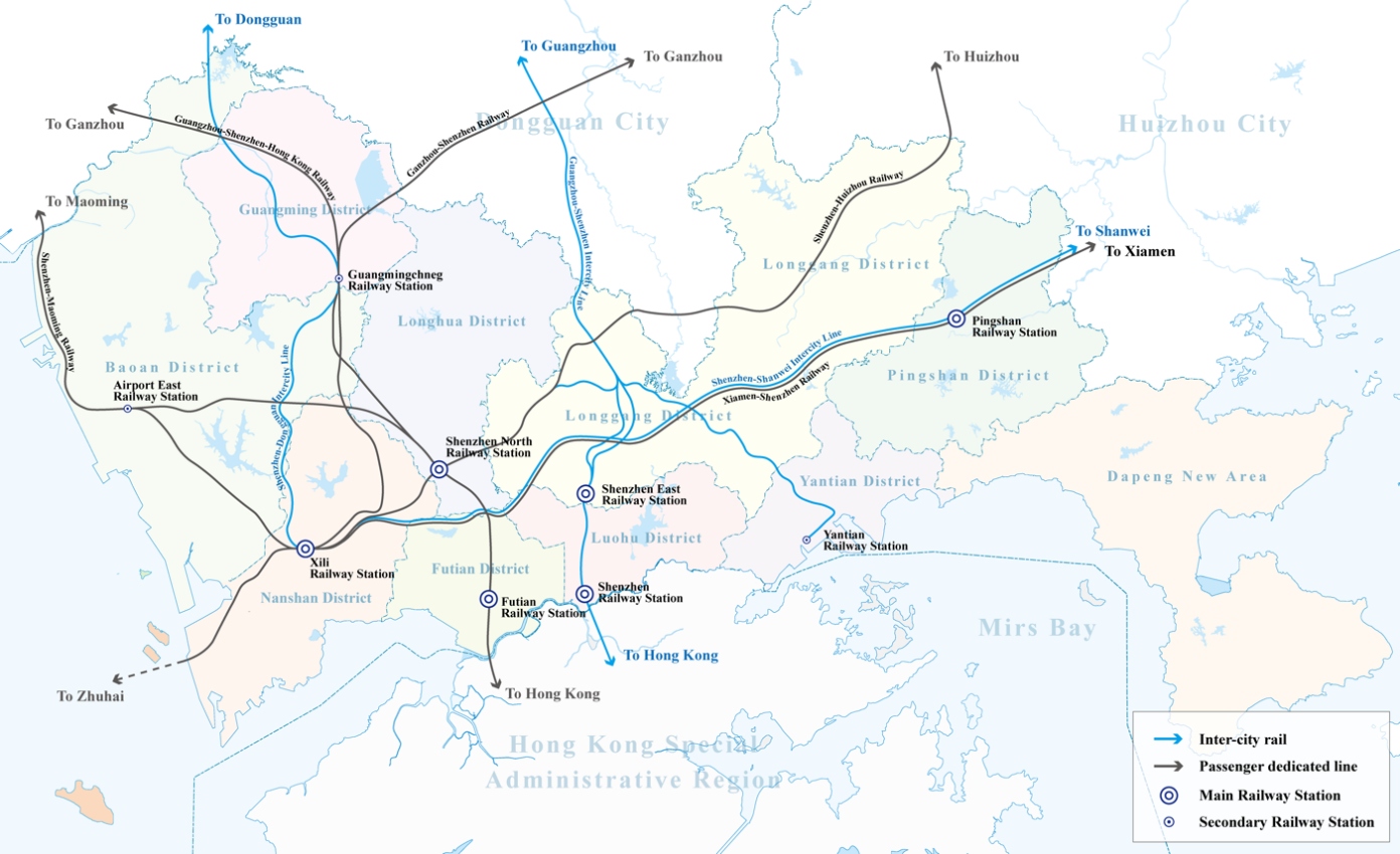
Figure 1: Shenzhen passenger rail network.
2.2. Shenzhen's Multi-Centric Urban Development Pattern
Shenzhen City has long insisted on a multi-centric spatial structure in urban spatial planning [9]. The earliest version of the "Shenzhen Special Economic Zone Master Plan" from 1986 established a spatial structure of "multiple points advancing together" and "belt-based clusters". Later, the 1996 "Shenzhen Urban Master Plan" introduced a development strategy of "expanding across the territory and advancing in gradients", constructing a "network-based cluster" spatial structure. The 2010 "Shenzhen Urban Master Plan" proposed a "north-south penetration, east-west expansion" spatial structure with "three axes, two belts, and multiple centers". The latest round of land and space planning introduces a "multi-centric, networked, and clustered" spatial structure. Ultimately, Shenzhen has formed a spatial development pattern of "north-south penetration, east-west expansion, central polarization, and wings stretching", dividing the urban space into five differentiated development zones, creating a three-tiered center system composed of the main center, sub-centers, and cluster centers, as shown figure 2, composed of clusters radiating between various urban centers [10].
After years of exploration, Shenzhen has essentially formed a consensus on using hubs as the focal points for urban development elements to promote the formation of cluster centers, allowing industry, land, population, capital, and other urban development elements to aggregate and disperse in different regions. Under the requirements of successive urban planning layouts, the development of Shenzhen's railway system TOD model has become a significant factor in supporting the formation of a multi-centric system.
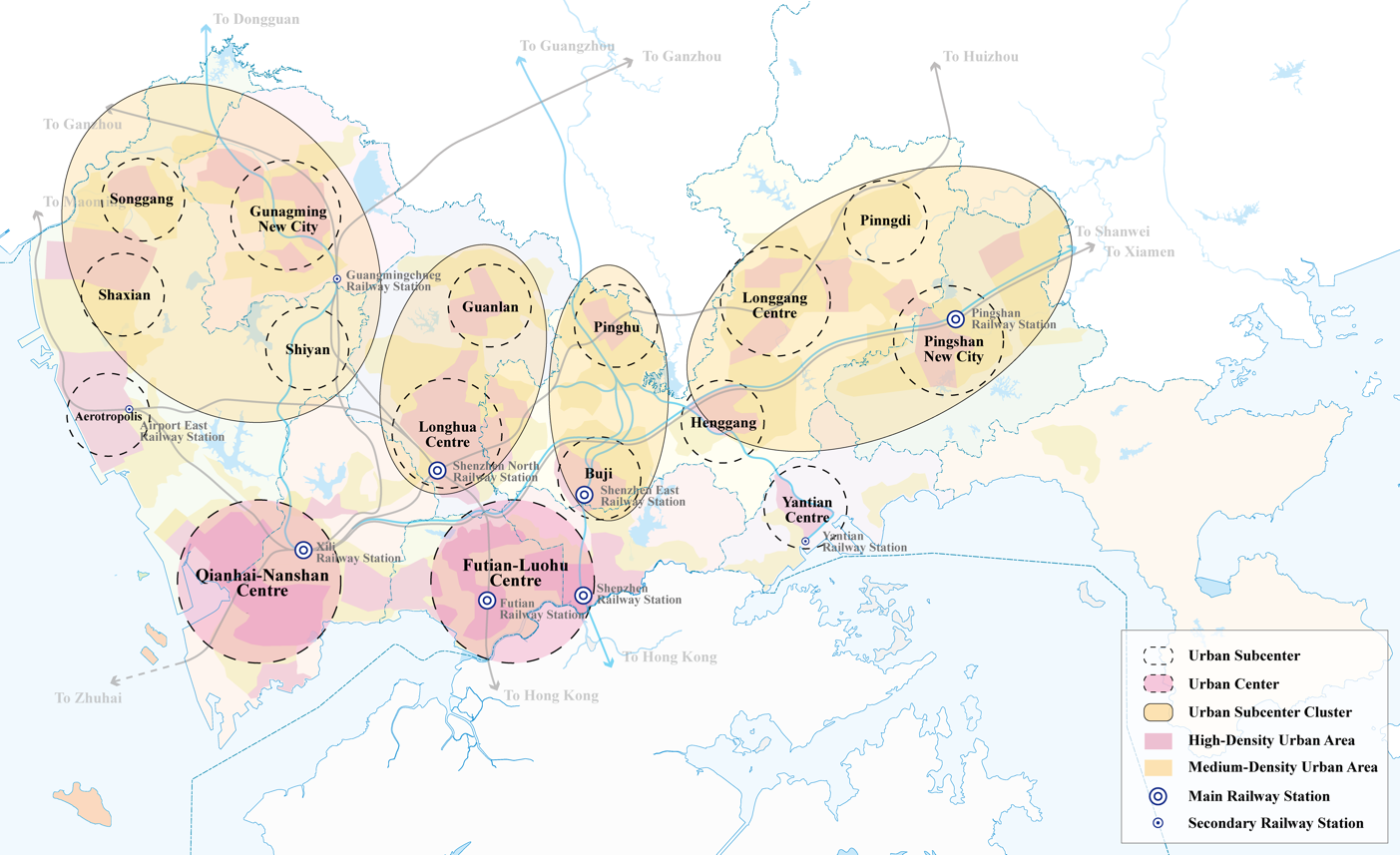
Figure 2: Shenzhen urban spatial structure.
2.3. Shenzhen Railway TOD Development Strategy Integrating Urban Layout
As a central city in the Guangdong-Hong Kong-Macao Greater Bay Area (hereinafter referred to as "the Greater Bay Area"), Shenzhen's main urban center should have the capability to radiate across the Pearl River Delta region encompassing the Guangzhou-Shenzhen-Hong Kong metropolis. Therefore, the regional intercity railway hub's anchoring in the main urban center is particularly vital [11]. Shenzhen's urban sub-centers should serve as specialized functional service agglomerations and cover the surrounding secondary urban areas; sub-centers are also regions where a large influx of population aggregates, hence national railway hubs should be prioritized in these areas. The functions of other secondary urban cluster centers and some key areas are to serve the city's internal production and life, driven by small railway hubs and the layout of other transportation facilities [11].
According to the aforementioned planning principles, the layout of Shenzhen's railway hubs presents a hierarchy of "main hubs - sub-hubs". The main urban centers, such as Bao'an, Luohu, and Futian, feature regional passenger stations like Airport East Station, Shenzhen Station, and Futian Station as railway hubs. They connect intercity railways that radiate across the Greater Bay Area with medium and short-distance conventional railways, taking on the function of business transfers between cities. Sub-centers such as Buji, Longhua, and Pingshan New City, serviced by national passenger stations like Shenzhen East, Shenzhen North, and Pingshan Station, and combined with the Xiamen-Shenzhen, Shenzhen-Maoming, and Guangzhou-Shenzhen railways, form comprehensive railway transfer functions that serve the nation. The remaining secondary city centers are mainly served by city-wide passenger stations that undertake hub functions, focusing on serving the city's internal passenger flow, mainly undertaking the transfer functions of the city's internal rail transit and bus passenger flow. They are coupled with the city's main and sub-centers and some key areas, undertaking the nurturing function of cluster centers and key regions [11].
Therefore, it is evident that the development layout of Shenzhen's various urban centers fundamentally reflects the integrated development concept of rail and city, achieving the city's railway TOD development model. Constructing railway hubs at different radiation scale levels drives the coordinated and stable development of Shenzhen's three-tiered urban layout.
3. Exploring the TOD Development Model of Shenzhen's Railway Transportation Based on the SWOT Model
3.1. Strength Analysis
3.1.1. Central Railway Hub Position in the Greater Bay Area
The Greater Bay Area, located in the Pearl River Delta region, is one of China's three major city clusters alongside the Yangtze River Delta and the Beijing-Tianjin-Hebei region. Currently, the Greater Bay Area's urban planning structure mainly presents Guangzhou and Shenzhen as dual centers, with the eastern and western banks of the Pearl River mouth being the focus. In terms of railway hubs, a dual-center railway network layout centered around Guangzhou and Shenzhen is evident. From the perspective of the Greater Bay Area, Shenzhen's railway hub is the convergence point for various railway lines on the eastern bank of the Pearl River, introducing coastal railway corridors and inland rail networks into the Pearl River Delta in a Y-shaped structure and extending west across the Pearl River to connect with the southwest corridor. At the same time, Shenzhen's railway hub is situated midway along the railway connection between mainland China and Hong Kong, serving as an important port of entry into Hong Kong. Therefore, Shenzhen occupies a central railway hub position within the city cluster of the Greater Bay Area, linking north to south and east to west, with significant strategic importance, thus bringing great advantages to its railway TOD development.
3.1.2. Relatively Developed Passenger Railway Infrastructure
Over the years since the Reform and Opening Up, Shenzhen has developed a relatively complete passenger railway network. Shenzhen has three main railway lines: the Guangzhou-Shenzhen Railway, the Guangzhou-Shenzhen-Hong Kong Railway, and the Xiamen-Shenzhen Railway, as well as two railway branch lines; the Shenzhen-Maoming Railway and the Shenzhen-Huizhou Railway, forming a "double cross" hub. In addition, the Ganzhou-Shenzhen High-Speed Railway and the Guangzhou-Dongguan-Shenzhen Intercity Railway are under construction. Spatially, the Guangzhou-Shenzhen Railway and the Guangzhou-Shenzhen-Hong Kong Railway run north-south, while the Xiamen-Shenzhen Railway runs east-west, converging at the Xili Railway Station through the Shenzhen-Maoming Railway and the Shenzhen-Huizhou Railway branch lines. In terms of railway stations, Shenzhen Station and Shenzhen North Station are the main passenger stations within the hub, with Shenzhen East Station, Shenzhen West Station, Futian Station, and Xili Station serving as auxiliary passenger stations. Furthermore, the intercity railway lines within the Shenzhen metropolitan area are shorter in length, designed for lower speeds, and feature smaller average distances between stations, which is more conducive to urban development along the railway lines. In summary, Shenzhen has a comprehensive railway planning structure, a long operational mileage, numerous railway stations, and a wide coverage area, providing a solid foundation for railway TOD development and a significant advantage.
3.1.3. Mature TOD Development Planning Experience
Shenzhen was one of the first cities in China to introduce and implement the TOD development model and possesses mature TOD planning concepts. Around 2010, Shenzhen established new districts such as Longhua, Guangming, and Dapeng, incorporating the TOD comprehensive development model into the construction of these districts. In 2011, leveraging the opportunity of hosting the 26th Summer Universiade, Shenzhen promoted the city-wide connectivity of its subway network, with five lines totaling 178 kilometers, effectively driving the development of urban sub-centers such as Bao'an Central District, Longgang Central District, and Longhua New Town. In 2014, Shenzhen proposed the important development concept that "building rail transit is equivalent to building a city," adopting the TOD model as a strategic urban transportation development approach.
Based on the fundamental network of urban rail transit, Shenzhen timely promoted the adjustment of the third phase of rail construction and the planning of the fourth phase, beginning to focus on supporting the guided development of key areas. Based on these key areas, the city implemented the integration and coordination of urban rail with urban space and activities, supporting TOD construction in key areas such as Qianhai Cooperation Zone, Shenzhen Bay Tech-Eco Park, Shenzhen Bay Headquarters Base, Liuxiandong Headquarters Base, and the International Low Carbon City [3]. In conclusion, Shenzhen has widely applied the TOD development concept in its planning and construction over the past decade and has gained valuable successful experiences from various aspects, bringing experience advantages to the TOD development of Shenzhen's railways.
3.2. Weaknesses Analysis
3.2.1. Fragmented Urban Planning Pattern
Over the past 30 years, Shenzhen has been committed to promoting a multi-center, group-style spatial layout, which has alleviated the traffic pressure in the city center to some extent. However, an analysis of the city's land development and traffic operations shows that due to the excessive concentration of commercial and office formats in the central urban area, the built-up area of the city presents a development trend that accumulates in the center and advances along the west, central, and east radial axes in gradients. This has resulted in a three-tier center system of the city's main center, secondary centers, and group centers, which form relatively independent urban clusters, leading to a fragmented urban development situation.
Under these conditions, a large commuter flow within the urban area needs to transfer at the boundaries of the clusters, which are usually urban ecological land or low-density development zones. This leads to a mismatch between the core development areas of the city and transportation hubs. On one hand, the core development areas outside the original Special Economic Zone lack transportation infrastructure support, and on the other hand, it concentrates a large commuter flow in bottleneck areas, causing traffic congestion during commuting periods [11]. Such a fragmented urban pattern brings considerable inconvenience to Shenzhen's overall transportation planning.
3.2.2. Many Restrictions on Urban Spatial Expansion
Shenzhen is surrounded by mountains on the west, north, and east sides. Within the urban area of Shenzhen, there are many hills such as Nanshan, Tanglang Mountain, Yinhu Mountain, Wutong Mountain, Maluan Mountain, Yangtai Mountain, and Phoenix Mountain, which account for 62.8% of the city's total land area. They are all urban parks or forest parks, dividing Shenzhen into multiple distinct blocks. Nanshan Park occupies the core section where Bao'an District meets Nanshan District, while Tanglang Mountain Park completely separates the overall north and south of Shenzhen, causing spatial isolation and independence between the southern core urban clusters of Nanshan, Futian, and Luohu and the northern secondary clusters, which is a great inconvenience for the integrated development of the urban area.
To the southwest and southeast of Shenzhen lies the sea. To the west, it faces the Pearl River Estuary, and to the east, it neighbors Daya Bay. To the southwest, Shenzhen Bay is across the water from Hong Kong, and it borders Hong Kong directly to the south. Under these conditions, Shenzhen has undergone large-scale reclamation, reaching nearly 120 square kilometers by 2020, accounting for 6% of the total area of Shenzhen. However, due to the severe ecological damage caused by reclamation, future large-scale land reclamation will no longer take place, and the urban area cannot expand outward anymore.
In summary, Shenzhen is situated between the northern mountains and the southern coast, only able to plan the city along the narrow coastal strip at the foot of the mountains and the small flat spaces between the mountains. As the urban land planned within the ecological protection framework is almost exhausted, Shenzhen's potential for outward expansion and inward development is extremely limited, severely constraining the future development space of the city.
3.2.3. Many Restrictions on Urban Spatial Expansion
Based on the multi-center urban planning pattern, Shenzhen's railway hub layout presents a "main hub - secondary hub" hierarchical structure. The main railway hubs, which handle long-distance passenger transportation nationwide, are primarily located in the city's secondary centers, while the hubs that handle short-distance intercity transportation are mainly situated in the city's primary center, serving to disperse transportation functions and alleviate operational pressure. However, such a station planning structure has significant flaws: when people in the city center and far suburbs need to travel long distances, they need to gather and board at the main hubs in the secondary centers, which means a long journey to and from the stations. Meanwhile, suburban residents who need to commute intercity have to travel to the railway secondary hubs in the city's main center to take the intercity railway, often resulting in a roundabout journey of departing from the suburbs, boarding in the city center, and disembarking in the neighboring city, facing a dilemma for suburban residents when using railway transportation.
Furthermore, Shenzhen's railway passenger service also suffers from uneven distribution. The western development axis of Shenzhen runs through the Qianhai Nanshan central area, Bao'an central cluster, and western industrial cluster, which are densely populated and economically developed, with a huge demand for long-distance railway services. However, the western region currently only has the Xili Station, and the hub station layout does not fully match the city's spatial layout and passenger flow demand, making the railway service function in the west weak. These flaws in the railway station planning also limit the further development of the railway TOD system.
3.3. Opportunity Analysis
3.3.1. Growing Demand for Intercity Rail Passenger Transport
With the booming development of the Greater Bay Area, there is a strong growth trend in the demand for rail passenger transport in the Shenzhen metropolitan area and its surrounding urban agglomerations. Due to the serious impact of the COVID-19 pandemic on people's mobility after 2020, this paper uses the railway passenger flow data from 2019. In 2019, the railway passenger volume in the Greater Bay Area of the Shenzhen metropolitan circle was 170 million, accounting for a market share of 24.6%, with a rail passenger transport demand intensity of 3.58 trips/person year, which is higher than the national average level (2.24 trips/person year). Over the past decade, the average annual growth rate of intercity rail passenger volume in the Greater Bay Area has been 7.3% from 2010 to 2018, with the volume in the Shenzhen metropolitan circle doubling, showing an extremely large demand for railway operation [12].
As the Shenzhen metropolitan area gradually develops, the cooperation between industries upstream and downstream within cities is strengthening, generating a large amount of intercity business travel demand. According to the annual travel surveys of Shenzhen residents, the demand for business and official trips is growing year by year, which brings long-term development opportunities for the Shenzhen railway TOD model [13].
3.3.2. Strong Support from Government Planning and Policies
The "Development Plan for the Shenzhen Metropolitan Circle" issued by the Guangdong Provincial Development and Reform Commission explicitly proposes to build an urban circle on the rail track, accelerate the construction of a national high-speed railway corridor centered in Shenzhen, with multi-directional radiation, internal networking, and interconnectivity [6]. It also emphasizes the vigorous promotion of integrated development of rail stations and cities, aiming to achieve unified planning, design, construction, and land space control of comprehensive transportation hubs, that is, the Shenzhen metropolitan circle TOD development model based on the railway system [6].
Under the national policy supporting the development of the intercity railway TOD model in the Shenzhen metropolitan circle, the Shenzhen government strongly supports the construction and operation of the intercity railway, building an urban circle on the rail track. Guided by passenger flow demand, it aims to create a first-class three-dimensional rail transit network, achieve efficiency in transport organization and operation services, and a networked passenger experience, bringing new opportunities for the development of Shenzhen's railway transportation TOD.
3.3.3. Development Potential of Surrounding Cities' Synergy
The coordinated development of various city groups and metropolitan circles will become the core of the economic development strategy of the Greater Bay Area. The focus is on leveraging the pivotal role of Shenzhen as a core city to promote the integrated development of Shenzhen-Dongguan-Huizhou, further stimulating the development potential of cities surrounding Shenzhen. This will bring new development opportunities to the intercity railway system centered on Shenzhen, as an increasing number of businesspeople and migrant workers will commute between Shenzhen and its neighboring cities, thereby further driving the TOD development and construction along the railway nodes.
3.4. Threats Analysis
3.4.1. Balance between Railway Stations and Urban Development
There is a certain degree of contradiction between the spacing of railway stations and the scope of urban development. Railways and their stations are planned linearly, requiring a certain distance between stations, whereas urban areas based on railway stations are planned on a flat plane, where the distance between stations should not be too far. Otherwise, the railway’s Transit-Oriented Development (TOD) function cannot be utilized effectively. Therefore, the planning of railway stations along the route necessitates comprehensive and rigorous considerations and trade-offs.
According to the standard speed of 350 km/h for China's high-speed railways, the minimum distance between stations is calculated to be approximately 25 km under conditions allowing trains to reach their maximum operating speed. Reviewing domestic high-speed railways that also serve intercity functions, the minimum station spacing ranges from 10-25 km [14]. With Shenzhen's jurisdiction spanning about 92 km from east to west and about 44 km from north to south, planning railway stations with a 25 km interval in such an urban space is a major challenge for TOD system planning. It involves balancing the development and transportation needs of various urban areas while avoiding competition between new and existing lines.
3.4.2. Difficulty in Transforming High-Density Urban Spaces
Shenzhen has a land area of about 1997 km², with the new round of national land space master planning proposing a total of 1105 km² for construction use. By 2019, the area for construction use had reached 974 km². Since 2012, the city’s land stock supply has exceeded incremental supply, indicating that the city has fully entered the stock development phase [14]. Statistics show that in 2018, Shenzhen's average gross floor area ratio for construction land exceeded 1.1, which is higher than the recognized high-intensity development in cities like Hong Kong at 0.97 (2019 data) and Tokyo at 0.8 (2020 data). Both central and non-central areas of the city exhibit an ultra-high-density growth spatial pattern [14]. In such a high-density urban space, how to transform existing stations into TOD, open new railway passages and stations, and coordinate complex land development issues and property rights is an urgent problem that needs to be addressed for the future development of the railway TOD model.
3.4.3. Government Subsidies and Corporate Investment Risks are Significant
Railway construction projects usually require substantial initial investment and have a long payback period, demanding a stable financial chain and presenting certain economic risks. Due to the public welfare nature of China's railway transportation, the investment in construction and operational subsidies are generally borne by government finances, but the economic benefits generated often do not sufficiently feedback to the investors and operators, leading to fiscal pressures on local governments. Hence, it is imperative to establish a comprehensive model for financing the development of rail transit, encompassing government capital investment projects, along with enterprises leveraging bank loans to cover residual funding. This model should facilitate the repayment of principal and interest as well as compensate for operational losses, aiming at the integrated development of underground, aboveground, and linear attributes. In the context of a slowing economy, how to avoid local fiscal debt risks, alleviate fiscal burdens, strengthen the comprehensive development of subway-related properties, and maximize economic returns are major challenges that the development of railway TOD will continue to face in the future.
3.5. Summary of Shenzhen's Railway Transit TOD Model
Upon conducting a comprehensive SWOT analysis of Shenzhen's railway transportation TOD development model, as presented in Table 1, it is evident that Shenzhen holds substantial advantages in the pursuit of a TOD model. These advantages are rooted in Shenzhen's pivotal position as a railway hub, its robust foundation in railway construction, and its matured experience in developmental planning. However, the fragmentation of the urban layout, limited expansion space, and the irrational setting of railway stations are all detrimental to the future development of Shenzhen's railway TOD model. Despite these disadvantages, Shenzhen's railway TOD model still has considerable development opportunities. The continuous economic growth of the Greater Bay Area has brought about an increasing demand for passenger transport, and the supportive planning policies of the government, along with the potential for interconnected development with neighboring cities, provide new market opportunities and greater development space for regional cooperation for the TOD model. Nevertheless, these opportunities also come with potential threats, such as balancing railway and urban planning, the transformation and renewal of high-density cities, along with the risks associated with government subsidies and corporate investments. These could pose challenges to the future TOD development in terms of coordination, cost, and financial stability.
Table 1: SWOT Analysis of the Development of Shenzhen Railway TOD.
Internal Factors | External Factors | |
1. City's key strategic position 2. Solid urban construction foundation 3. Multi-centric urban pattern 4. City's geographical environment 5. Issues continuously arising in development practice | 1. Sustained economic growth of the Greater Bay Area 2. Higher-level planning and concepts proposed by the government 3. City development space limitations 4. Economic environment impacts and investment model constraints | |
Advantages | Strengths | Opportunities |
1. Central railway hub status 2. Well-established railway construction foundation 3. Mature development planning experience | 1. Increasing demand for railway passenger transport 2. Strong support from government planning policies 3. Development potential of synergies with surrounding cities | |
Disadvantages | Weaknesses | Opportunities |
1. Fragmented urban pattern 2. Limited urban expansion space 3. Unreasonable railway station settings | 1. Balancing railway and city planning 2. Remodeling and renewal of high-density cities 3. Risks associated with government subsidies and corporate investments |
4. Conclusion
This study based on the urban structure of Shenzhen, railway layout, and development strategies, and through the SWOT analysis of Shenzhen's railway traffic TOD (Transit-Oriented Development) model, reveals that Shenzhen's railway TOD possesses significant potential for development, while also facing numerous challenges. Due to a solid foundation in construction and long-term urban planning, Shenzhen enjoys considerable advantages in terms of its urban hub status, railway construction foundation, and development planning experience. However, geographic constraints and deviations in construction practices mean that Shenzhen has certain disadvantages in urban planning structure, urban expansion space, and railway station settings. In the current environment of increasing railway passenger demand, government policy support, and the integrated development of surrounding urban areas, Shenzhen's railway TOD has favorable development opportunities. Yet, with issues concerning the planning of railway stations, land development in high-density cities, and the economic risks to project investors, Shenzhen faces many challenges.
This study assesses the status and prospects of Shenzhen's railway TOD development, providing a reference for future planning by the Shenzhen municipal government and relevant railway departments. It aids urban planners in identifying and evaluating various factors, thereby formulating more effective development strategy plans. In the context of Shenzhen's railway system, there is a need to appropriately enhance the station density of existing lines and to flexibly organize and operate stoppage schemes for various passenger rail lines. This includes interconnecting key stations to facilitate railway connections between the primary and secondary urban centers. Furthermore, the implementation of new technologies such as smart city and intelligent dispatching should be employed to manage train operations, aiming to digitize and intelligentize Shenzhen's railway system. This approach aims to mitigate the developmental constraints caused by the dispersal of the urban landscape and promote the shared prosperity and development of various urban centers. The Shenzhen government needs to build on its existing advantageous foundation, seize development opportunities, overcome current disadvantages, and meet new challenges more actively and flexibly. By doing so, it will turn Shenzhen into a rational, efficient, and sustainable TOD city based on rail transit, achieving the integrated development of the Shenzhen metropolitan area through rail transit.
References
[1]. Wang, Y.P., Deng, Z.H. (2022) SWOT Analysis of the TOD Mode of Urban Rail Transit in Tianjin. Value Engineering, (09), 42-44.
[2]. Zhang, X.C., Tian, F., Lu, G.L., Shao, Y. (2011) The TOD Framework and Planning Strategies of Shenzhen City. Urban Transport of China, (03), 37-44.
[3]. Urban Planning and Design Institute of China. (2022) TOD Development Case Study of Shenzhen: A Domestic Demonstration City TOD Development Case Study by the Project Management Office of the Ministry of Housing and Urban-Rural Development.
[4]. Shao, Y., Huang, Q.X., Yi, C.Y., Jiang, J. (2022) Conception of the Comprehensive Transportation "Fourteenth Five-Year" Plan in Shenzhen City. Urban Transport of China, (01), 44-51.
[5]. Lin, Y. (2019) Reflections on the Overall Planning of Shenzhen Railway Hub. World of Transport, (23), 27-28.
[6]. The People's Government of Guangdong Province. (2023) Development Plan of Shenzhen Metropolitan Circle.
[7]. Shenzhen City Planning and Land Resources Committee. (2017) Shenzhen Urban Planning and Land Resources Development Research Center. Shenzhen Urban Rail Transit Network Plan.
[8]. Planning And natural Resources Bureau of Shenzhen Municipal People’s Government. (2021) Territorial Spatial Master Planning of Shenzhen.
[9]. Guo, L., Sun, Y.H., Peng, K.K. (2015) Traffic Assessment of Shenzhen City's Spatial Structure under Multiple Scenarios. Urban Transport of China, (02), 19-25.
[10]. Zou, B. (2017) The Evolution of Shenzhen's Urban Spatial Structure and the Evaluation of Planning Effectiveness. Urban and Rural Planning, (06), 69-79.
[11]. Deng, Q., Guo, L., Yang, T. (2015). Passenger Transport Organization under the Multi-Center Spatial Structure of Shenzhen City. Urban Transport of China, (02), 26-33+77.
[12]. Xiong, C. (2022) Shenzhen Metropolitan Circle Intercity Railway Train Operation Scheme (Dissertation, China Academy of Railway Sciences).
[13]. Liu, Y.P., Yan, Y., Zhong, S.M. (2021) Optimization Strategy and Key Issues of Intercity Railway Planning in the Shenzhen Metropolitan Circle. Urban Rail Transit Studies, (08), 17-22.
[14]. Tang, W., Zeng, X. (2023) Research on the Planning of High-Speed Railway Lines Introduced into a Super Large City: A Case Study of the Shenzhen-Shanwei High-Speed Railway. 468-477.
Cite this article
Zhu,H. (2024). TOD Development in Shenzhen Rail Transit Based on SWOT Model. Advances in Economics, Management and Political Sciences,95,8-18.
Data availability
The datasets used and/or analyzed during the current study will be available from the authors upon reasonable request.
Disclaimer/Publisher's Note
The statements, opinions and data contained in all publications are solely those of the individual author(s) and contributor(s) and not of EWA Publishing and/or the editor(s). EWA Publishing and/or the editor(s) disclaim responsibility for any injury to people or property resulting from any ideas, methods, instructions or products referred to in the content.
About volume
Volume title: Proceedings of the 2nd International Conference on Management Research and Economic Development
© 2024 by the author(s). Licensee EWA Publishing, Oxford, UK. This article is an open access article distributed under the terms and
conditions of the Creative Commons Attribution (CC BY) license. Authors who
publish this series agree to the following terms:
1. Authors retain copyright and grant the series right of first publication with the work simultaneously licensed under a Creative Commons
Attribution License that allows others to share the work with an acknowledgment of the work's authorship and initial publication in this
series.
2. Authors are able to enter into separate, additional contractual arrangements for the non-exclusive distribution of the series's published
version of the work (e.g., post it to an institutional repository or publish it in a book), with an acknowledgment of its initial
publication in this series.
3. Authors are permitted and encouraged to post their work online (e.g., in institutional repositories or on their website) prior to and
during the submission process, as it can lead to productive exchanges, as well as earlier and greater citation of published work (See
Open access policy for details).
References
[1]. Wang, Y.P., Deng, Z.H. (2022) SWOT Analysis of the TOD Mode of Urban Rail Transit in Tianjin. Value Engineering, (09), 42-44.
[2]. Zhang, X.C., Tian, F., Lu, G.L., Shao, Y. (2011) The TOD Framework and Planning Strategies of Shenzhen City. Urban Transport of China, (03), 37-44.
[3]. Urban Planning and Design Institute of China. (2022) TOD Development Case Study of Shenzhen: A Domestic Demonstration City TOD Development Case Study by the Project Management Office of the Ministry of Housing and Urban-Rural Development.
[4]. Shao, Y., Huang, Q.X., Yi, C.Y., Jiang, J. (2022) Conception of the Comprehensive Transportation "Fourteenth Five-Year" Plan in Shenzhen City. Urban Transport of China, (01), 44-51.
[5]. Lin, Y. (2019) Reflections on the Overall Planning of Shenzhen Railway Hub. World of Transport, (23), 27-28.
[6]. The People's Government of Guangdong Province. (2023) Development Plan of Shenzhen Metropolitan Circle.
[7]. Shenzhen City Planning and Land Resources Committee. (2017) Shenzhen Urban Planning and Land Resources Development Research Center. Shenzhen Urban Rail Transit Network Plan.
[8]. Planning And natural Resources Bureau of Shenzhen Municipal People’s Government. (2021) Territorial Spatial Master Planning of Shenzhen.
[9]. Guo, L., Sun, Y.H., Peng, K.K. (2015) Traffic Assessment of Shenzhen City's Spatial Structure under Multiple Scenarios. Urban Transport of China, (02), 19-25.
[10]. Zou, B. (2017) The Evolution of Shenzhen's Urban Spatial Structure and the Evaluation of Planning Effectiveness. Urban and Rural Planning, (06), 69-79.
[11]. Deng, Q., Guo, L., Yang, T. (2015). Passenger Transport Organization under the Multi-Center Spatial Structure of Shenzhen City. Urban Transport of China, (02), 26-33+77.
[12]. Xiong, C. (2022) Shenzhen Metropolitan Circle Intercity Railway Train Operation Scheme (Dissertation, China Academy of Railway Sciences).
[13]. Liu, Y.P., Yan, Y., Zhong, S.M. (2021) Optimization Strategy and Key Issues of Intercity Railway Planning in the Shenzhen Metropolitan Circle. Urban Rail Transit Studies, (08), 17-22.
[14]. Tang, W., Zeng, X. (2023) Research on the Planning of High-Speed Railway Lines Introduced into a Super Large City: A Case Study of the Shenzhen-Shanwei High-Speed Railway. 468-477.