


1. Introduction
Forests regulate the circulation of air and water in nature, affect climate change, protect soil from wind and rain, and reduce the harm caused to people by environmental pollution, which has an indispensable value. In recent years, global warming has led to more and more extreme weather and natural environmental disasters, and wildfires are one of them. In 2021, under the influence of climate, fuel, fire source, and other factors, forest fires are showing an outbreak trend in the world. Continuously burning forest fires seriously threaten life, property, and ecological safety, release a large number of harmful gases, and affect regional air quality. Therefore, monitoring forest fires is of great significance for improving the natural environment, and ensuring the safety of personnel and property.
Traditional fire monitoring mainly includes thermal monitoring, radiation monitoring, smoke monitoring, and so on. However, these monitoring means have limitations and deficiencies. First, their prevention capacity is limited. Traditional electrical fire prevention and control methods mainly include fuses, circuit breakers, arresters, etc. These devices can only reduce the occurrence of electrical fires to a certain extent, but often cannot find the potential safety hazards in time. Secondly, its response speed is slow. Traditional electrical fire prevention and control means need manual inspection and operation, the response speed is slow, and they cannot find and deal with anomalies and emergencies in the electrical system in time. In addition, traditional means of electrical fire prevention and control can not achieve remote monitoring and management, the need for manual inspection and operation, increasing the labor cost and management difficulty. The study of Mu Chenying et al. found that the existence of remote sensing technology made up for this defect [1]. Fire point monitoring by satellite remote sensing has the characteristics of wide monitoring range, accurate positioning, dynamic tracking, and relatively low cost, etc., which has great advantages in macro dynamic fire monitoring. At present, many domestic departments use pole-orbiting meteorological satellites to monitor large-scale forest fires, grassland fires, and straw burning. In the application of forest fire prevention, remote sensing technology saves manpower and material resources, and the monitoring of forest fires is more accurate and rapid, which is conducive to reducing the frequency of forest fires, thereby reducing environmental, economic, and personnel losses.
In particular, in July 2021, large-scale wildfires broke out in North America, Siberia, the Amazon rainforest, the Mediterranean Sea, and other regions. This fire not only caused a large number of losses but also led to serious environmental pollution. Therefore, dynamic fire monitoring based on remote sensing is very important for the timely and efficient planning of rescue measures [2].
This paper will focus on the advantages of remote sensing technology for preventing and monitoring forest fires. Firstly, this paper analyzes the inducement of forest fires, and secondly analyzes the impact of forest fires on the environment, economy, and personnel. In addition, the advantages of remote sensing for forest fire monitoring are described in detail, and its practical application is illustrated. Finally, it is summarized. It is hoped that this research will bring improvement and help to reduce the natural, human, and economic losses caused by fire.
2. Causes of forest fires
The causes of forest fires can be classified into both natural and man-made categories.
(1) Natural factor
Firstly, considering the overall impact on the natural environment, in recent years, global warming, and the intensification of the greenhouse effect have led to increased sun exposure in forest environments. Consequently, the vegetation temperature has risen, increasing the risk of spontaneous combustion of trees. At the same time, when thunderstorms and rock collapse and other disasters come, it may cause electric shock fire, rock and forest collision friction fire, and other situations. Secondly, from the point of view of specific natural factors, there is more ground cover in the forest, such as the huge area of dead leaves seeds and fruits, the greater the accumulation of such objects, the greater the possibility of causing fire. At the same time, there are differences in leaf shape and internal water content between coniferous forests and broadleaf forests. Coniferous forest contains a lot of oil, while broadleaf forest has plenty of water, and the fire risk of the two trees is also different. Finally, forest fire is also related to soil, slope direction, dry and wet degree, and other factors. On the whole, although natural factors are uncontrollable, their probability of occurrence is far lower than that of human factors.
(2)Human Factors
The first is the productive use of fire. Most of them need to use fire to produce or improve efficiency when people engage in productive activities such as farming and animal husbandry production and forest sideline industry in a forest environment. If the fire suppression is not timely or incomplete after use, it will lead to forest fires. The second is the non-productive use of fire. Although there are few types of such fire sources, there are many cases. According to statistics, China has identified the fire cause of forest fires, 99.4% is caused by man-made fire, of which 31.6% of the fire is caused by productive fire, and burning reclamation, burning forest fires caused by more times, the rest is caused by non-productive fire, outdoor smoking, cooking fire, burning paper is the most common 3 kinds of fire sources[3]. In addition, intentional arson is also included. This can happen for a variety of reasons, such as the forest affecting its interests, or the forest impeding its interests, which is egregious and must be resolutely eradicated. The last is improper fire prevention and control. Such behaviors, such as the fire source control is not careful and strict, the fire use system is not standardized and perfect, and the fire prevention fund being insufficient, resulting in the fire prevention infrastructure is not perfect, etc., will lead to the occurrence of forest fires.
3. Impact of Forest Fire
Pine and fir in the forest can secrete diterpenoids and other gases “bactericidin”, which can kill diphtheria, typhoid, and other germs in the air, thus evolving the air. Forests regulate the circulation of air and water in nature, affect climate change, protect soil from wind and rain, and reduce the harm of environmental pollution created by people However, the occurrence of forest fires leads to the destruction of the natural environment, a large number of farmland, infrastructure, etc., is destroyed, resulting in huge economic and human losses.
As shown in Figure 1, both the area of the fire site and the number of fires fluctuated greatly during 1999-2018. In terms of the number of casualties caused by forest fires during 1999-2018, according to statistics, the total number of casualties caused by forest fires in China was 2323, and the average annual number of casualties was 116.15. According to the study of Li Shuang et al., both the number of forest fires and the area of the overfired area showed a decreasing trend from 2011 to 2018, which was significantly lower than that of the previous decade, but the average number of casualties showed an increasing trend on the contrary. To explore the correlation between the number of forest fires, the area of the overfired area and the casualties, Li Shuang et al. used SPSS 26 software to conduct a correlation analysis of the three, and the analysis results showed that the number of casualties was mainly positively correlated with the number of fires but had no obvious relationship with the area of the overfire area.
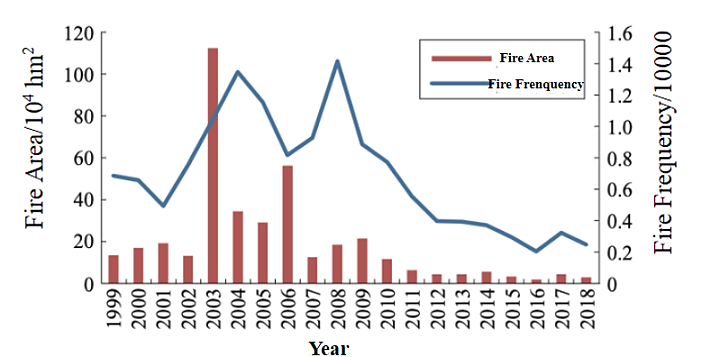
Figure 1. Interannual changes in statistical indicators of fire area and fire frequency from 1999 to 2018 [2].
In terms of economic loss caused by forest fires during the same period, according to statistics, the total economic loss caused by forest fires in China is 2.65×10⁵ million yuan, and the average annual economic loss is 1.33 × 10⁴ million yuan. According to the study of Li Shuang et al., from 2011 to 2018, although the number of forest fires and the area of the overfired area both showed a downward trend year by year, the average economic loss increased significantly compared with the previous ten years. On the one hand, it may be because, with the continuous development of China’s economy, the infrastructure around forests has been improved. The spread of forest fires led to the damage and burning of factories, houses, Bridges, railways, and transmission lines around the forest area. On the other hand, it may be because as China attaches great importance to forest fire prevention, more manpower and material resources are invested in forest fire fighting [2]. Similarly, to further study the correlation between the number of forest fires, the area of overfired area, and economic loss, Li Shuang et al. used SPSS 26 software to conduct a correlation analysis of the three, and the analysis results showed that there was no obvious correlation between economic loss and the number of fires and the area of overfired area. This may be because the economic loss is more related to the intensity of a forest fire and the factories, houses, and other infrastructures around the forest [4].
A horizontal comparison between China and other countries shows that the casualties caused by forest fires in China during 1988-2012 were relatively serious, and the proportion of casualties in forest fires was much higher than that in other countries with frequent forest fires in the same period [5]. For example, the number of forest fires in the United States during 1988-2012 was ten times that of China. And Canada, where the forest area burned was 30 times that of China. Therefore, both the human and economic losses caused by fires are huge, and China still has a long way to go to reduce the harm caused by fires.
At the same time, forest fires cause significant harm to the natural ecosystem and natural environment: severe fires are extremely destructive, and the burning of large areas of green vegetation will significantly reduce the surface’s function of conserving water, which will lead to natural disasters such as flash floods, mudslides and soil erosion. In terms of the global carbon cycle, forest fires also have a significant impact on it: before the fire, land conversion and deforestation cause forests to release a lot of carbon, according to the extent of damage caused by these fires, carbon emissions will increase, further accelerating climate change; And in each forest fire, a certain percentage of the soil will escape burning and form “residual” carbon-carbon deposits in forest fires.
4. Advantages and applications of remote sensing for fire monitoring
According to Zhou Ying’s research on the application of remote sensing in forest fire automatic monitoring, Mercator projection is adopted for fire monitoring. The automatic fire monitoring system can quickly find the location of the fire point, the time limit is 1-3 days earlier than that of conventional ground monitoring means [6].
And can calculate the fire area in a large range. In 1996, the remote sensing information found hot spots in Yunnan, Vietnam, and Laos, and the data was stored. The field data of the forest fire prevention department of Yunnan Province confirmed that the relative error between the remote sensing data and the measured value was as small as 0.69%. The advantages of remote sensing technology for forest fire monitoring are as follows. Firstly, the remote sensing system can accurately read the longitude and latitude of the fire point and quickly locate the fire point. Compared with the conventional monitoring methods on the ground, the remote sensing system is less affected by factors such as terrain and weather, and its timeliness is high, so that the disaster can be found and located as early as possible, and the success rate of rescue can be improved. Secondly, the computer of the remote sensing system can scan all the fire points in a large range and automatically calculate the area of each fire area and the total fire area, with high accuracy, which provides basic information for the fire site and is conducive to the fire site rescue. In addition, in the post-disaster inspection to ensure that the fire has been completely controlled, compared with the ground conventional monitoring methods such as extending the time of staying at the fire point, multiple field inspections, etc., the remote sensing system can monitor the fire point situation in real time to save manpower and material resources and reduce monitoring costs.
Table 1. Basic information on forest fires in Inner Mongolia in 2018.
No. of Fire Area | Central longitude | Central latitude | Number of fire point pixels | Pixel coverage area (sq. km) | Open flame area (ha) |
1 | 121.5 | 52.38 | 42 | 31.67 | 1.49 |
2 | 122.6 | 51.75 | 56 | 42.83 | 1.76 |
In the example application of Fengyun-3 meteorological satellite remote sensing in forest fire monitoring, Yang Lei et al. used satellite remote sensing VIRR to monitor forest fire points in Inner Mongolia and Heilongjiang. Figure 2 shows the fire information based on remote sensing image positioning, namely, the forest fire that occurred in the National Key protected forest area of the Greater Hinggan Mountains in Inner Mongolia on June 1, 2018, and the forest fire caused by a lightning strike in the Hanma National Nature Reserve and the northern primitive forest area respectively. In the Fengyun-3 satellite remote sensing data, the VIRR mid-infrared channel is mainly used to monitor the high-temperature heat source points. From the above figure, two fire points in Inner Mongolia National Nature Reserve can be seen. Then, the number of pixels of fire point, pixel coverage area, and open flame area information are calculated, as shown in Table 1.
As can be seen in Figure 3(a), through several days of fire tracking and monitoring, it can be seen from the satellite remote sensing data on the 3rd that the open fire of the No. 1 fire point is basically extinguished. As can be seen in Figure 3(b), the location of the No. 2 fire point begins to shift to the eastern line and gradually burns into Huzhong Nature Reserve of the Greater Hinggan Mountains forest area of Heilongjiang Province for about 1 km. For dynamic monitoring using remote sensing technology, it should be noted that, on the one hand, the method of extracting the information data of the overfired area has significant regional differences. In actual practice, the extraction method should be determined according to the ecological characteristics of the region, the physical characteristics of the overfired area itself, and the corresponding spectral and histogram analysis. On the other hand, the extraction accuracy of the burned area can be further improved by using the geographical spatial relationship. Forest fires generally occur in mountains with a certain altitude, and the sites have obvious geographical spatial characteristics. For example, only areas with an elevation greater than a certain height are likely to become over-fire areas, while residential areas or bare wastelands are impossible. In this way, over-fire areas can be avoided from mixing with ground features such as residential areas and bare wastelands, thereby improving extraction accuracy [7].
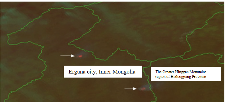
Figure 2. Remote sensing image location of forest fires in Inner Mongolia in 2018 [7].
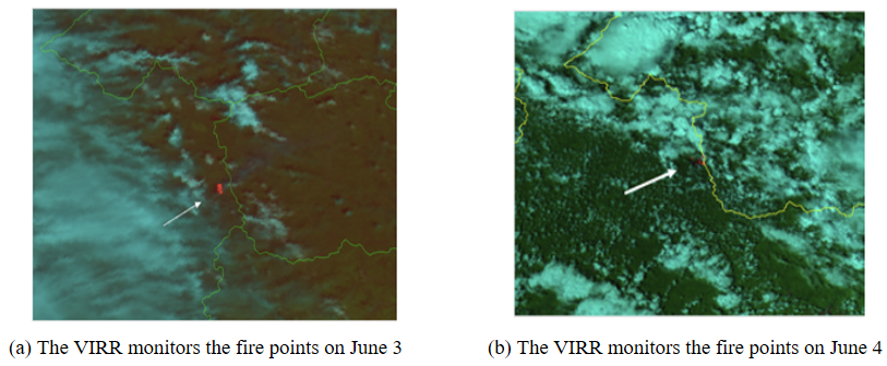
Figure 3. Fire points monitored by VIRR in the early and later stages of forest fires: (a)fire image on June 3; (b)fire image on June 4 [7].
5. Suggestions
China still has a lot of room for improvement in forest fire prevention and remote sensing applications.
From the point of view of prevention, it is very important to enhance citizens’ awareness of fire prevention. Ye Xueling’s research shows that fire prevention attitude has a positive driving effect on citizens’ fire prevention awareness; Fire prevention knowledge and subjective norms directly drive citizens’ fire prevention awareness; Fire prevention knowledge and subjective norms indirectly drive citizens’ fire prevention awareness through fire prevention attitude. Therefore, it is of great significance to correct serious fire prevention attitudes and propagate fire prevention knowledge through publicity and education [8]. This paper has two suggestions on the publicity methods: On the one hand, the fire publicity department can provide more effective publicity. From the perspective of public demand and public opinion attention, to provide effective publicity to the masses, so that the masses are willing to accept, more intuitive feel the content of fire propaganda [9]. On the other hand, emerging network media such as WeChat, Weibo, and Douyin can be used to spread widely and quickly, and popular science videos can be released on relevant platforms to expand the number of receiving groups of fire prevention knowledge and awareness and save a lot of manpower and material resources.
For the application of remote sensing, the cost of forest fire detection is larger than that of manual or aircraft. At the same time, with the continuous development of science and technology, remote sensing technology should be gradually applied to forest fire detection work, because it can well promote the development of forest fire prevention. First of all, this paper proposes its application in forest fire prediction and forecasting work, which is to analyze the fire source and weather in the forest at a certain time, and then predict the possibility of forest fires [10]. The second is to suggest its application in forest fire monitoring work. Forest fire monitoring is an important content of forest fire prevention. It mainly refers to a process of collecting, transmitting, and analyzing relevant information of forest fires with a certain probability through relevant technologies. Through forest fire monitoring, it can effectively promote the orderly development of forest fire prevention work and provide more accurate information for staff.
6. Conclusions
This paper focuses on the advantages of remote sensing technology in forest fire monitoring by using the methods of searching literature and data, analyzing and researching literature. This paper first explains the causes of forest fires, which are divided into natural and man-made aspects, and then studies the impacts of forest fires on the natural environment, economy and personnel. It is found that the fire area and the number of fires has fluctuated greatly in the past 20 years in China. In addition, the advantages of remote sensing technology in forest fire monitoring are analyzed in detail through the study of several literatures, and the practical application cases of remote sensing in Yunnan Province and Inner Mongolia Autonomous Region are cited. Through the cases, it is found that remote sensing can accurately and quickly locate the fire point, and quickly calculate the number of fire point pixels, pixel coverage area and open fire area information. Finally, this paper puts forward suggestions on forest fire prevention, which is conducive to enhancing public awareness of fire prevention. In terms of remote sensing applications, it puts forward suggestions for forest fire monitoring with remote sensing technology which is cheaper than traditional ground monitoring methods. This paper provides references of data, literature, and examples for the application of remote sensing technology in monitoring and reduction of forest fires, which is conducive to providing relevant data, literature and examples for scholars studying the application of remote sensing in practical life, and at the same time, it is conducive to providing suggestions on forest fire prevention and for workers engaged in forest fire protection.
Since this paper mainly analyzes and studies the existing literature, there is a slight shortage of drawing images. In the future, it will be studied in the aspects of drawing images and acquiring images, and combine the research and analysis of literature with drawing and creating images to form a more comprehensive and perfect study.
References
[1]. Mu C Y, Xu Q H, Zhang J 2016 Application of RS and GIS technology in Shenyang Fire monitoring The 33rd Annual Meeting of the Chinese Meteorological Society S21 new-generation meteorological satellite technology development and application
[2]. Bai Y, Wang B, Wu Y D 2022 Overview of global forest fires in 2021 Fire Sci. Technol. 005 p 041
[3]. Lu Y J 2021 Inducing factors and forest fire prevention and control measures Modern rural science and technology 7 p 1
[4]. Li S, Cao M, Zhu Y P 2023 Study on temporal and spatial distribution characteristics of forest fire economic loss and casualties Fire Sci. Technol. 42(3) pp 387-391
[5]. Yang G, Shu L F, Sun S Q et al. 2015 Study on temporal and spatial distribution characteristics of casualties in forest fires in China J.Catastrophology 30(02)pp21-25.
[6]. Zhou Y 2021 Application of satellite remote sensing information system in forest fire and drought monitoring Guizhou geology 18 (2) p4
[7]. Yang L, Wang J, Gao Y H, et al 2019 Based on cloud number three examples of meteorological satellite remote sensing in forest fire monitoring application J. Environment and Development 31 (1)p 2
[8]. Ye X L 2019 A preliminary study on the influencing factors of fire prevention awareness of citizens in Baiyunshan Scenic Area of Guangzhou Shelter forest science and technology 6 p 4
[9]. Dong A 2017 Some thoughts on how to improve citizens’ awareness of fire safety at present stage Chemical industry of jiangxi province 2 p 3
[10]. Zhong C W 2021 The application of remote sensing technology in forest fire prevention study Ecological environment and protection 4 (5) pp 26-28
Cite this article
Fang,Q. (2024). The advantages of using remote sensing technology to monitor forest fires. Applied and Computational Engineering,60,42-48.
Data availability
The datasets used and/or analyzed during the current study will be available from the authors upon reasonable request.
Disclaimer/Publisher's Note
The statements, opinions and data contained in all publications are solely those of the individual author(s) and contributor(s) and not of EWA Publishing and/or the editor(s). EWA Publishing and/or the editor(s) disclaim responsibility for any injury to people or property resulting from any ideas, methods, instructions or products referred to in the content.
About volume
Volume title: Proceedings of the 4th International Conference on Materials Chemistry and Environmental Engineering
© 2024 by the author(s). Licensee EWA Publishing, Oxford, UK. This article is an open access article distributed under the terms and
conditions of the Creative Commons Attribution (CC BY) license. Authors who
publish this series agree to the following terms:
1. Authors retain copyright and grant the series right of first publication with the work simultaneously licensed under a Creative Commons
Attribution License that allows others to share the work with an acknowledgment of the work's authorship and initial publication in this
series.
2. Authors are able to enter into separate, additional contractual arrangements for the non-exclusive distribution of the series's published
version of the work (e.g., post it to an institutional repository or publish it in a book), with an acknowledgment of its initial
publication in this series.
3. Authors are permitted and encouraged to post their work online (e.g., in institutional repositories or on their website) prior to and
during the submission process, as it can lead to productive exchanges, as well as earlier and greater citation of published work (See
Open access policy for details).
References
[1]. Mu C Y, Xu Q H, Zhang J 2016 Application of RS and GIS technology in Shenyang Fire monitoring The 33rd Annual Meeting of the Chinese Meteorological Society S21 new-generation meteorological satellite technology development and application
[2]. Bai Y, Wang B, Wu Y D 2022 Overview of global forest fires in 2021 Fire Sci. Technol. 005 p 041
[3]. Lu Y J 2021 Inducing factors and forest fire prevention and control measures Modern rural science and technology 7 p 1
[4]. Li S, Cao M, Zhu Y P 2023 Study on temporal and spatial distribution characteristics of forest fire economic loss and casualties Fire Sci. Technol. 42(3) pp 387-391
[5]. Yang G, Shu L F, Sun S Q et al. 2015 Study on temporal and spatial distribution characteristics of casualties in forest fires in China J.Catastrophology 30(02)pp21-25.
[6]. Zhou Y 2021 Application of satellite remote sensing information system in forest fire and drought monitoring Guizhou geology 18 (2) p4
[7]. Yang L, Wang J, Gao Y H, et al 2019 Based on cloud number three examples of meteorological satellite remote sensing in forest fire monitoring application J. Environment and Development 31 (1)p 2
[8]. Ye X L 2019 A preliminary study on the influencing factors of fire prevention awareness of citizens in Baiyunshan Scenic Area of Guangzhou Shelter forest science and technology 6 p 4
[9]. Dong A 2017 Some thoughts on how to improve citizens’ awareness of fire safety at present stage Chemical industry of jiangxi province 2 p 3
[10]. Zhong C W 2021 The application of remote sensing technology in forest fire prevention study Ecological environment and protection 4 (5) pp 26-28