


1.Introduction
With the accelerated process of urbanization and the thriving development of tourism, the connection between urban transportation hubs and tourist destinations has become increasingly intertwined. Walking, as a convenient mode of transportation, plays a significant role in urban tourism. Research on the improvement of urban transportation contributes to sustainable development. Urban forms that are in proximity to public transportation hubs hold paramount importance for promoting tourism. Pedestrian accessibility, being one of the indicators to measure the quality of urban transportation systems, holds significant importance for enhancing tourist experiences and fostering urban sustainability [1].
In this context, this paper aims to explore pedestrian accessibility from urban transportation hubs to tourist destinations, taking the renowned tourist attraction, Yuyuan Garden, in Shanghai as a specific case study. Urban transportation hubs refer to transportation facilities located within the city, such as subway stations and bus stops. Tourist destinations are places where visitors go for sightseeing and leisure, often possessing certain attractiveness and cultural value. Pedestrian accessibility measures the convenience of pedestrians traveling from one location to another and is commonly developed as a standard to assess the suitability of a community for walking. It can be defined as the ease of walking to relevant destinations [2].
As an important economic hub and international metropolis in China, Shanghai has witnessed continuous growth in its tourism industry. Yuyuan Garden, a significant tourist destination within the urban area of Shanghai, boasts a rich historical and cultural heritage, attracting a large number of visitors annually [3]. However, there may be room for improvement in pedestrian accessibility from urban transportation hubs to tourist destinations in practical applications. This holds crucial significance for enhancing the tourist experience, alleviating traffic congestion, and promoting urban sustainable development.
Therefore, the motivation of this study is to delve into the pedestrian accessibility between Shanghai Yuyuan Station and Yuyuan Garden using the spatial syntax approach. Spatial syntax, as a tool for analyzing spatial structures and relationships, can reveal the modes of connection and levels of accessibility among different spatial elements. From the perspective of spatial syntax, this paper will explore the layout, advantages, disadvantages, and feasibility of public transportation hubs and their pedestrian spaces, providing valuable insights and guidance for urban planners and tourism managers. Additionally, it will offer methods and insights for similar studies on pedestrian accessibility between other tourist destinations and transportation hubs in similar cities, contributing positively to the direction of urban development toward a healthier, greener, and smarter future.
2.Research object and spatial syntax
2.1.Analysis of the Yuyuan area in Shanghai and its pedestrian status
Yuyuan Garden is one of the renowned attractions in Shanghai, and Yuyuan Street where it is located constitutes a significant part of the historic Old City area of Shanghai. This historical district showcases characteristics of small scale, high density, and diversity [4]. With the large-scale urban renewal and development of tourist attractions, the local visitor influx has significantly increased. Strengthening traffic management and establishing pedestrian-friendly spaces emerge as potential and necessary choices to enhance accessibility [5]. Simultaneously, Yuyuan Station serving the garden and nearby bus stops play a crucial role as the primary means of arrival and departure for a substantial number of visitors. The integration of walking and public transportation offers a constructive approach to creating pedestrian-friendly spaces around the attraction and its limited surroundings.
2.2.Advantages and limitations of spatial syntax in pedestrian accessibility assessment
Spatial syntax is a rigorous and scientific quantitative research method in urban studies. It focuses on the relationships between spaces and their connections, employing techniques such as axial analysis, integration measures, and model verification to reveal and depict the inherent patterns of cities. Based on this foundation, it formulates urban design proposals, Utilizing spatial syntax to analyze pedestrian accessibility from the scenic area to transportation hubs holds positive significance for the construction of pedestrian-friendly spaces [6].
However, spatial syntax also has its limitations. The drawing of axial maps is a crucial process within spatial syntax, and the meaningful application of spatial syntax relies on the analysis of these axial maps. The creation and refinement of axial maps require a substantial amount of manual effort and continuous adjustments based on actual field visits. The complexity of the study subject can also impact the accuracy of axial map development, particularly in cases like the Yuyuan Garden area, where high pedestrian traffic and intricate transportation components are present. Consequently, there are still certain constraints to the application of spatial syntax in this context.
3.Based on spatial syntax analysis of pedestrian accessibility
3.1.Research object and scope
The scope of this study encompasses the spatial area enclosed by Henan South Road, Fuxing East Road, and Renmin Road. The focal point of the research is the pedestrian pathways from the entrances and exits of Yuyuan Garden to the surrounding key transportation hubs, including Yuyuan Garden Station Exit 1 and bus stops. Factors such as the existing main streets and pedestrian environment in the spatial area will be considered at the same time.
3.2.Spatial syntax indicators for pedestrian accessibility assessment
Obtaining the flat map and satellite imagery of the research area through Google Maps, conducting on-site investigations and visits, and based on the maps and field research, creating a pedestrian axial map for the area are included in the research process. This axial map is based on pedestrian functionality and differs from roadways for motor vehicles, particularly emphasizing differentiation in cases of mixed pedestrian and vehicular traffic, as well as commercial streets. The axial map is drawn with specific markers indicating transportation hubs. After the completion of the axial map, it will be imported into Depthmap to ensure the thorough connectivity of the axes.
Convert the axial map into a segment map for further analysis. This paper employs depth and choice analyses based on step count and angles, with a particular emphasis on choice. This approach can effectively highlight tourists’ path preferences and choices between attractions and transportation hubs. The integration measure reflects residents’ and tourists’ perceptions of the street network structure within the block and their travel choices.
3.3.Data processing and analysis
The Yuyuan Garden area and its surrounding blocks represent a relatively typical example of “narrow alleys, dense road network” neighborhoods. The corners of its residents’ communities and the planned transportation network for the scenic area are more intricate. There are numerous intersections between small streets, which significantly influence tourists’ visual perceptions and their direct choices of travel routes. In the segment model, the paths of tourists are vectorized, with each individual straight segment treated as a vector. The sum of angles formed by all vectors along the tourist’s path is referred to as the Angular Total Depth. Total Depth reflects the potential of an element to attract arrivals at transportation nodes, while Choice reflects the potential of an element to attract pedestrian flow across transportation nodes [7]. In this paper, Choice and its modified formula are employed to derive Normalized Choice, which is calculated as follows (1):
\( NormalizedChoice(p)=\frac{Choice(p)}{Total Depth(p)} \ \ \ (1) \)
|
|
|
|
|
(a) |
(b) |
(c) |
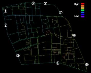
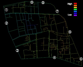
Figure 1. (a)Angular Total Depth centered around the entrance of Yuyuan Garden, (b) Angular Total Depth centered around the exit of Yuyuan Garden, (c) Angular Total Depth centered around the subway station entrance.
By analyzing the axial map and segment map as shown in Figure 1, we derive Angular Total Depth, Total Depth, Choice, and Integration [HH] as spatial syntax variables. Angular Total Depth requires data collection from both the entrance and exit of the scenic area. These calculations yield the results of spatial syntax variables, as shown in Table 1.
Table 1. Calculation results of spatial syntactic variables of transportation hubs in Yuyuan area
|
Station number |
1 |
2 |
3 |
4 |
5 |
6 |
7 |
8 |
9 |
|
Ref Number |
0 |
330 |
327 |
179 |
175 |
171 |
163 |
159 |
99 |
|
Station name |
Metro Exit 1 |
Henan South Road and Fuyou Road |
Henan South Road and Fuxing East Road |
Fuxing East Road and Guangqi Road |
Dadongmen |
Xiaodongmen |
Renmin Road and Xinkaihe Road |
City God Temple |
Xinbei Gate |
|
Angular Total Depth(a) |
5.65234 |
3.58203 |
3.65234 |
4.49609 |
6.09766 |
6.35938 |
5.55078 |
4.91406 |
4.74609 |
|
Angular Total Depth(b) |
4.4375 |
2.36719 |
2.51563 |
3.35938 |
4.96094 |
5.22266 |
3.625 |
2.98828 |
2.82031 |
|
Total Depth |
3405 |
2632 |
2255 |
2220 |
2949 |
3058 |
3540 |
3291 |
2973 |
|
Choice |
0 |
13577 |
26518 |
12944 |
1999 |
3082 |
838 |
1333 |
6898 |
|
Integration [HH] |
0.624 |
0.858238 |
1.02693 |
1.04602 |
0.75408 |
0.723872 |
0.614941 |
0.666776 |
0.747214 |
|
NormalizedChoice |
0.000000 |
5.158435 |
11.759645 |
5.830631 |
0.677857 |
1.007848 |
0.236723 |
0.405044 |
2.320215 |
4.Pedestrian accessibility evaluation and analysis from Yuyuan garden scenic area to surrounding transportation hubs
Tourists’ behaviors and their choices of transportation modes are influenced by factors such as travel purposes, personal health status, and weather conditions. During their travels, tourists also pay increased attention to the service quality of transportation networks [8]. This paper primarily evaluates the service level of the transportation network from Yuyuan Garden scenic area to surrounding transportation hubs based on accessibility. It highlights existing issues and proposes specific optimization recommendations.
4.1.Analysis of station accessibility status
Visitors traveling from transportation hubs to the entrance of tourist destinations and vice versa, from the exit of tourist destinations to transportation hubs, constitute the primary pathways for tourists choosing the public transportation-pedestrian system for their journeys. By centering on each entrance and exit, two Angular Total Depth values for each transportation hub are obtained, and the final results are depicted in Figure 2 as shown.
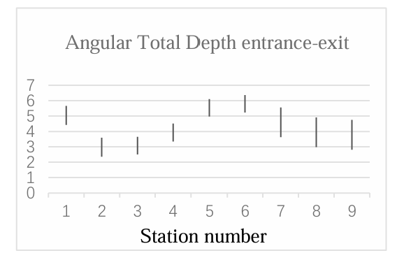
Figure 2. Angular Total Depth entrance-exit
Transportation hubs with low Angular Total Depth values and small differences imply higher overall accessibility when considering both entrance and exit scenarios. Analyzing the results, it is apparent that Station 2 and Station 3 exhibit higher accessibility, indicating better services provided by the connected road network and pedestrian spaces. Subsequently, based on this, the probability of road selection is reanalyzed. This paper employs the algorithm of Choice. Station 3 has the highest Normalized Choice, while Subway Exit 1 has a Normalized Choice of 0. This model has limitations when analyzing arrivals at the entrance of tourist destinations. This is because the analysis of the axial network diagram does not account for pedestrian flow and the service capacity of Yuyuan Station itself. However, it provides a certain reference for road choices after tourists have finished visiting the scenic area. Tourists are more inclined to select transportation hubs with lower Total Depth values. Therefore, Station 3 holds the greatest potential for serving tourists.
4.2.Low pedestrian accessibility at subway station entrances and exits
Centered around Subway Yuyuan Garden Station Exit 1, the Angular Total Depth values for the entrance and exit of Yuyuan Garden are 4.4375 and 5.65234, respectively. The results reveal that the locations of the Yuyuan Garden entrances and exits are not particularly friendly to passengers choosing the subway for travel. Tourists are required to navigate through relatively long distances of streets, which imposes limitations on the subway, a high-volume transportation mode, especially during specific festive periods. This presents significant challenges to the capacity of the subway and its road network. When considering the tourist destination as the core, the probability of choosing Yuyuan Garden Station is at a disadvantage when tourists make their selections among the surrounding streets. This could be attributed to various factors, such as the complexity of streets around Yuyuan Garden Station, high commercial density, and extensive green areas. These factors impact the accessibility of Yuyuan Garden Station, subsequently influencing tourists’ choices. As a result, more visitors tend to opt for alternative public transportation methods or taxis to leave the Yuyuan Garden area after visiting the tourist destination.
4.3.Optimization strategies
(1) Rationally optimize the roads around subway stations. Expand pedestrian spaces to increase the capacity of road pedestrian areas while ensuring pedestrian safety. Pay attention to the conflict between motor vehicles and pedestrians, especially during specific festive periods, to alleviate traffic congestion.
(2) Implement signage guidance. Subway stations play a crucial role in alleviating tourist pressure, and fully leveraging the connectivity between the subway and pedestrian paths is an important approach. Street management authorities should enhance directional signage by installing signboards and pavement markings to guide tourists between the subway stations and Yuyuan Garden scenic area. Additionally, it is essential to control the scale of surrounding commercial activities, as excessively large commercial developments may attract higher levels of pedestrian traffic.
(3) Leverage the advantages of bus stops. According to the analysis results, the Henan South Road and Fuxing East Road bus stop exhibits the highest potential in terms of pedestrian accessibility and choice. Strengthening directional signage and expanding the platform size can fully exploit its transportation strengths. Simultaneously, implementing reasonable dedicated bus lanes, enhancing commercial activities along the route, and adding greenery can attract tourists to choose this transportation hub.
5.Conclusion
This paper employs the theory of spatial syntax and combines on-site investigations to conduct a research evaluation of pedestrian accessibility from urban transportation hubs to tourist destinations. The final results indicate that the major transportation hubs around Yuyuan Garden have a relatively low attractiveness for tourists’ choices. Tourists have limited options for public transportation and encounter certain obstacles when traveling from transportation hubs to the entrance of the scenic area.
The method of obtaining spatial syntax data is straightforward and yields intuitive results, which holds significant implications for further research on transportation network accessibility and the spatial arrangement of commercial areas, tourist attractions, and historical districts. However, spatial syntax possesses certain limitations such as abstraction, neglect of temporal attributes, and insufficient qualitative analysis, especially in the process of generating axial maps, there is a certain degree of subjectivity in the resulting drawings, which could potentially lead to some imperfections [9]. Pedestrians have access to extensive space and freedom, there are also more subjective factors involved in the selection of pedestrian spaces and the creation of their models [10]. The experimental results have limitations in explaining the characteristics of the road network structure. Therefore, in order to capture a broader range of pedestrian transportation network attributes and delve deeper into the influences of various factors on pedestrian accessibility, further research and the integration of more effective methods are necessary.
References
[1]. ADOLPHSON M. Urban morphology, lifestyles and work-related travel behaviour: Evidence from the Stockholm region [J/OL]. Transportation Research Interdisciplinary Perspectives, 2022, 16: 100706. DOI:10.1016/j.trip.2022.100706.
[2]. LIANG Z, NG K F, HUAI Y. A stated preference approach for measuring walking accessibility [J/OL]. Transportation Research Part D: Transport and Environment, 2023, 122: 103876. DOI:10.1016/j.trd.2023.103876.
[3]. Chen Peipei. Exploration of the Current Situation, Issues, and Countermeasures of Shanghai Tourism Development [J]. Rural Science Experiment, 2022(22): 237-239.
[4]. Yuan Fei, Ge Liang. A Study on Historical Districts of Old City in Shanghai: Research on Historical Street Blocks by the National Research Center for Historic Cities and Towns [J]. Urban Planning, 2023, 47(4): 117-118.
[5]. Zhang Hongxin. Research on Traffic Organization Issues in the Old City Area: A Case Study of Fandong Street Area [J]. Transportation and Port, 2017, 4(3): 37-40.
[6]. Zhu Kajia, Zhou Ruochong, Liu Yang. The Value and Innovative Application of Spatial Syntax in Urban Planning [J]. Shanxi Architecture, 2019, 45(11): 21-22.
[7]. HILLIER W R G, YANG T, TURNER A. Normalising least angle choice in Depthmap - and how it opens up new perspectives on the global and local analysis of city space [J]. Journal of Space Syntax, 2012, 3(2): 155-193.
[8]. BURSA B, MAILER M, AXHAUSEN K W. Travel behavior on vacation: transport mode choice of tourists at destinations [J/OL]. Transportation Research Part A: Policy and Practice, 2022, 166: 234-261. DOI:10.1016/j.tra.2022.09.018.
[9]. HILLIER B. Space is the machine: a configurational theory of architecture [M]. Space Syntax, 2007.
[10]. NAGATANI T. Four species CA model for facing pedestrian traffic at rush hour [J/OL]. Applied Mathematical Modelling, 2012, 36(2): 702-711. DOI:10.1016/j.apm.2011.07.013.
Cite this article
Tao,Z. (2024). Study on pedestrian accessibility from urban transportation hubs to tourist destinations: A case of Shanghai Yuyuan station to Yuyuan garden. Applied and Computational Engineering,62,283-288.
Data availability
The datasets used and/or analyzed during the current study will be available from the authors upon reasonable request.
Disclaimer/Publisher's Note
The statements, opinions and data contained in all publications are solely those of the individual author(s) and contributor(s) and not of EWA Publishing and/or the editor(s). EWA Publishing and/or the editor(s) disclaim responsibility for any injury to people or property resulting from any ideas, methods, instructions or products referred to in the content.
About volume
Volume title: Proceedings of the 2nd International Conference on Mechatronics and Smart Systems
© 2024 by the author(s). Licensee EWA Publishing, Oxford, UK. This article is an open access article distributed under the terms and
conditions of the Creative Commons Attribution (CC BY) license. Authors who
publish this series agree to the following terms:
1. Authors retain copyright and grant the series right of first publication with the work simultaneously licensed under a Creative Commons
Attribution License that allows others to share the work with an acknowledgment of the work's authorship and initial publication in this
series.
2. Authors are able to enter into separate, additional contractual arrangements for the non-exclusive distribution of the series's published
version of the work (e.g., post it to an institutional repository or publish it in a book), with an acknowledgment of its initial
publication in this series.
3. Authors are permitted and encouraged to post their work online (e.g., in institutional repositories or on their website) prior to and
during the submission process, as it can lead to productive exchanges, as well as earlier and greater citation of published work (See
Open access policy for details).
References
[1]. ADOLPHSON M. Urban morphology, lifestyles and work-related travel behaviour: Evidence from the Stockholm region [J/OL]. Transportation Research Interdisciplinary Perspectives, 2022, 16: 100706. DOI:10.1016/j.trip.2022.100706.
[2]. LIANG Z, NG K F, HUAI Y. A stated preference approach for measuring walking accessibility [J/OL]. Transportation Research Part D: Transport and Environment, 2023, 122: 103876. DOI:10.1016/j.trd.2023.103876.
[3]. Chen Peipei. Exploration of the Current Situation, Issues, and Countermeasures of Shanghai Tourism Development [J]. Rural Science Experiment, 2022(22): 237-239.
[4]. Yuan Fei, Ge Liang. A Study on Historical Districts of Old City in Shanghai: Research on Historical Street Blocks by the National Research Center for Historic Cities and Towns [J]. Urban Planning, 2023, 47(4): 117-118.
[5]. Zhang Hongxin. Research on Traffic Organization Issues in the Old City Area: A Case Study of Fandong Street Area [J]. Transportation and Port, 2017, 4(3): 37-40.
[6]. Zhu Kajia, Zhou Ruochong, Liu Yang. The Value and Innovative Application of Spatial Syntax in Urban Planning [J]. Shanxi Architecture, 2019, 45(11): 21-22.
[7]. HILLIER W R G, YANG T, TURNER A. Normalising least angle choice in Depthmap - and how it opens up new perspectives on the global and local analysis of city space [J]. Journal of Space Syntax, 2012, 3(2): 155-193.
[8]. BURSA B, MAILER M, AXHAUSEN K W. Travel behavior on vacation: transport mode choice of tourists at destinations [J/OL]. Transportation Research Part A: Policy and Practice, 2022, 166: 234-261. DOI:10.1016/j.tra.2022.09.018.
[9]. HILLIER B. Space is the machine: a configurational theory of architecture [M]. Space Syntax, 2007.
[10]. NAGATANI T. Four species CA model for facing pedestrian traffic at rush hour [J/OL]. Applied Mathematical Modelling, 2012, 36(2): 702-711. DOI:10.1016/j.apm.2011.07.013.