


1. Introduction
The development of green and low-carbon transportation is an important measure for the transportation industry to strengthen the construction of ecological civilization, serve the national goal of carbon peak and carbon neutrality, and fight the battle of pollution prevention and control. In order to implement Xi Jinping's thought on ecological civilization as well as the "Opinions of the Central Committee of the Communist Party of China and the State Council on the complete and accurate implementation of the new development concept to do a good job of carbon peak carbon neutral work [1]. Opinions of the CPC Central Committee and State Council on Deepening the Battle Against Pollution Prevention and Control Outline for the Construction of a Stronger Transportation State [2]. The Ministry of Transportation and Communications (MOTC) has issued the Green Transportation Standard System [3] and the Green Transportation Standard System (2022) [4]. It aims to further promote energy saving and carbon reduction, pollution prevention and control, ecological environment protection and restoration, and resource saving and intensive utilization in the field of transportation to make up for the shortcomings, strengthen the weaknesses, and promote enhancement, accelerate the formation of green and low-carbon modes of transportation, promote the harmonious development of transportation and nature, and provide a strong support for the promotion of sustainable development of the city and the acceleration of the construction of a strong nation of transportation.
On September 22, 2020, president Xi Jinping announced during the general debate of the 75th United Nations General Assembly that China's carbon dioxide emissions are striving to peak by 2030, and to achieve carbon neutrality by 2060 [4]. The transportation industry is one of the major industries in energy consumption and greenhouse gas emissions, and is an important area to improve air quality, achieve greenhouse gas emission reduction and mitigate climate change, as well as a key and difficult area to influence the city's carbon peaking and transportation pollution reduction.
The above provides an urgent background and demand for promoting the construction of low-carbon green transportation demonstration zones. Kunming, as one of the first batch of "National Bus City Construction Demonstration Cities", "National Low-Carbon Transportation Pilot Cities", "Pilot Cities of Green Travel Creation" and "National Smart Bus Demonstration Cities", has basically established the main position of green travel in urban transportation. As the first batch of "National Bus City Construction Demonstration City", "National Low Carbon Transportation Pilot City", "Pilot City of Green Travel Creation" and "National Intelligent Public Transportation Demonstration City", the city has basically established the main position of green travel in urban transportation, and possesses a good foundation for low-carbon transportation development. As transportation hubs and commercial centers in Kunming, Wuhua District's Zhengyi Road area and Sanshi Street area have become important bottlenecks restricting the sustainable development of the city. This study aims to propose innovative solutions to the transportation problems in the core area of Wuhua District, with the goal of building a low-carbon green transportation demonstration area.
2. The current situation in the area of Zhengyifang and Sanshi Street in Wuhua District, Kunming
2.1. Description of the area
Located in the center of Kunming City, the Zhengyifang and Sanshi Street areas are important commercial and cultural gathering areas in the city, with high daily pedestrian flow and significant traffic pressure. At the same time, the traffic problems in this area are typical, and the study of its traffic status and improvement measures has a strong demonstration and promotion value.
2.2. Current situation
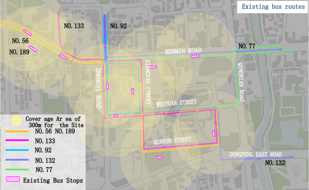
(1) Problems of public transportation, such as Figure 1, conventional bus, site coverage, walking the main street and auxiliary street neighborhoods around the bus stops densely, Nanping Pedestrian Street, the entire line are in the conventional bus stops within 300 meters of the coverage, but the bus service is inefficient.
Initial formation of networked operation of the rail: 5 rail transit lines have been opened for operation (including 1 branch), the initial formation of networked operation, Line 3 Wuyi Road Station site 500m can fully cover Zhengyi Road Pedestrian Street and Nanping Street Pedestrian Street.
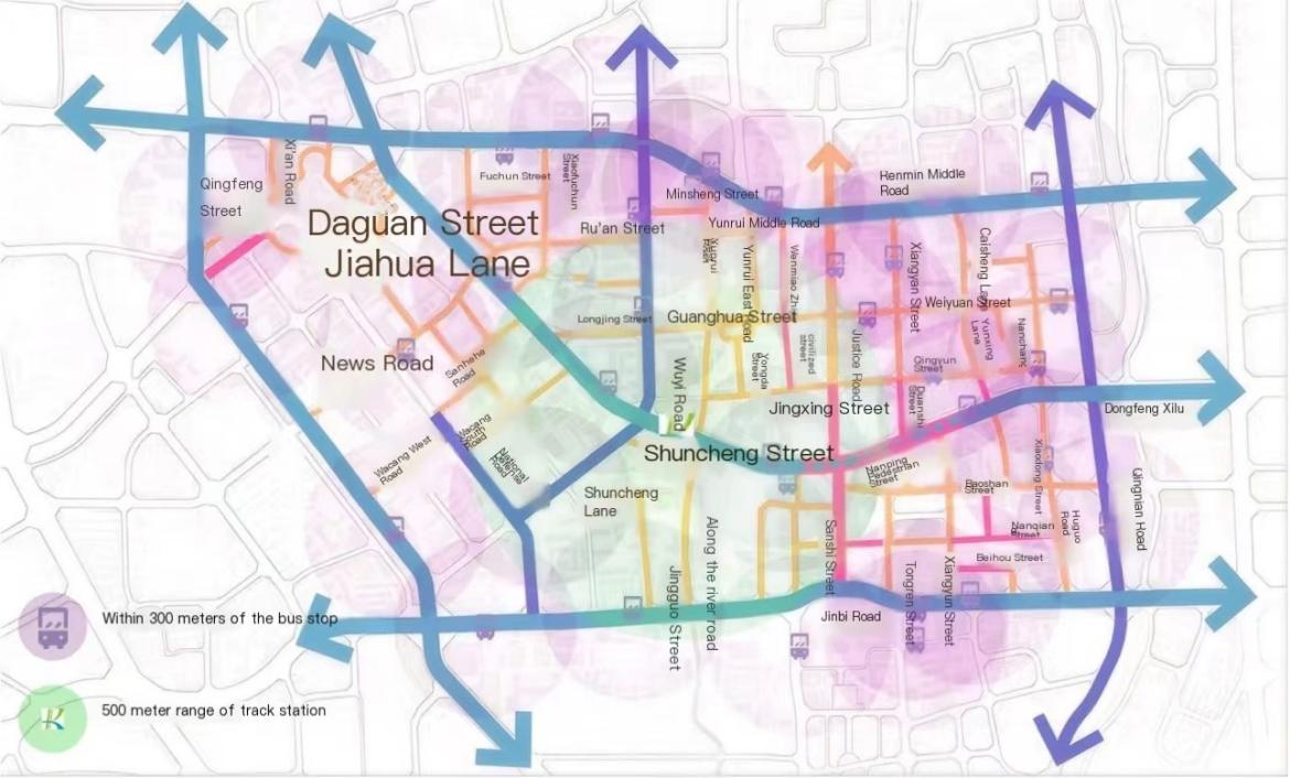
Figure 1. Map of rail and bus coverage
(2) The characteristics of the pedestrian street, with obvious boundaries and discontinuous. Pedestrian street and the surrounding road slow moving articulation facilities are perfect: pedestrian street and the surrounding motor vehicle operation section of the current situation to pedestrian crosswalks, overpasses, underpasses and other slow moving facilities articulation, better to meet the needs of pedestrians to cross the street, to ensure the continuity between the slow moving facilities.
There are clear management boundaries, motorized isolation facilities, and manual management of the road sections with surrounding motor vehicles to ensure the safety and comfort of the pedestrian zone. There are comprehensive signage at the entrances and exits of the pedestrian street (see Figure 2 and Figure 3).
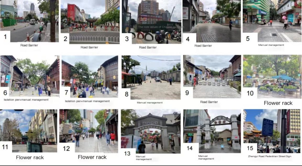
Figure 2. Management measure
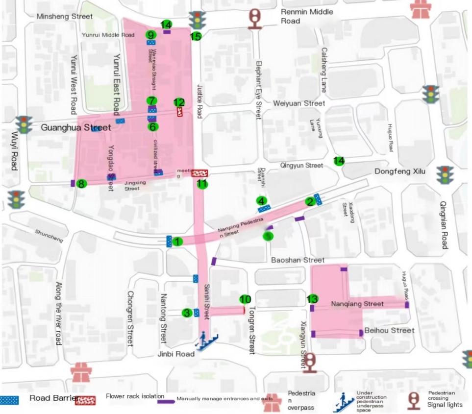
Figure 3. Corresponding position
(3) Non-motorized parking is a problem, chaotic and unorganized, encroaching on the slow-moving space. All motorized and non-motorized vehicles are prohibited within Nanping Pedestrian Street, and there are segregation facilities and management personnel to maintain the entrances and exits.
Mainly concentrated in the vicinity of commercial and office buildings, most of the parking spots are located on the sidewalks, seriously encroaching on the sidewalks, and are managed and charged for. A small portion of the use of the front area of the building is designated as a parking area, belonging to the self-parking, and has a person to manage. Some parking is primarily in front of commercial and restaurant establishments along the street. Parking order is average, but encroachment on the sidewalk is serious.
(4) Motorized vehicle parking problems, occupying non-motorized space, and parking in the front area of the building concentrated around commercial and office buildings, seriously occupying public space (Figure 4).
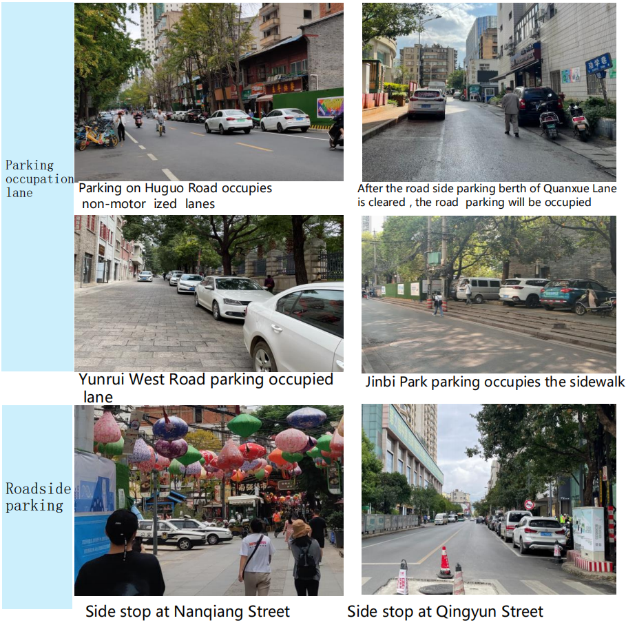
Figure 4. Motor vehicle parking situation
3. Design Principle
3.1. Design thinking
Firstly, this study analyzes and summarizes the traffic characteristics and problems through field investigation of the current situation of the area, public transportation resources, public transportation coverage, non-motorized parking spots, motorized vehicle parking information, pedestrian entrances and exits, signage information, and the slow-moving system.
Then, combined with the famous foreign pedestrian street area Oxford Street in London, Hong Kong Mongkok district traffic planning and traffic organization and management experience, put forward the pedestrian street upgrading and transformation objectives, "individual motorization reduction + green travel increase + pedestrian street increase + non-motorized parking space specific" as the core, from the integration of the district traffic organization. It proposes planning strategies, detailed planning schemes and specific implementation measures in four aspects, such as integrating district traffic organization, public transportation services, upgrading the spatial quality of streets and building intelligent transportation.
Finally, slow traffic, public transport, non-motor vehicles, street space quality, and other systems are coordinated to promote the integration of the three networks of "rail transit network + conventional bus network + slow traffic network", establish a "bus + walking" travel system, and guide the public to give priority to choosing The public will be guided to give priority to public transportation, walking and cycling as green modes of transportation. During the implementation process, the "people-oriented" planning concept is maintained, the street space is purified, and the quality of the street space is comprehensively upgraded, which has a demonstration and leading role in creating "green mobility" in the core area of Kunming City. The design concept is shown in Figure 5.
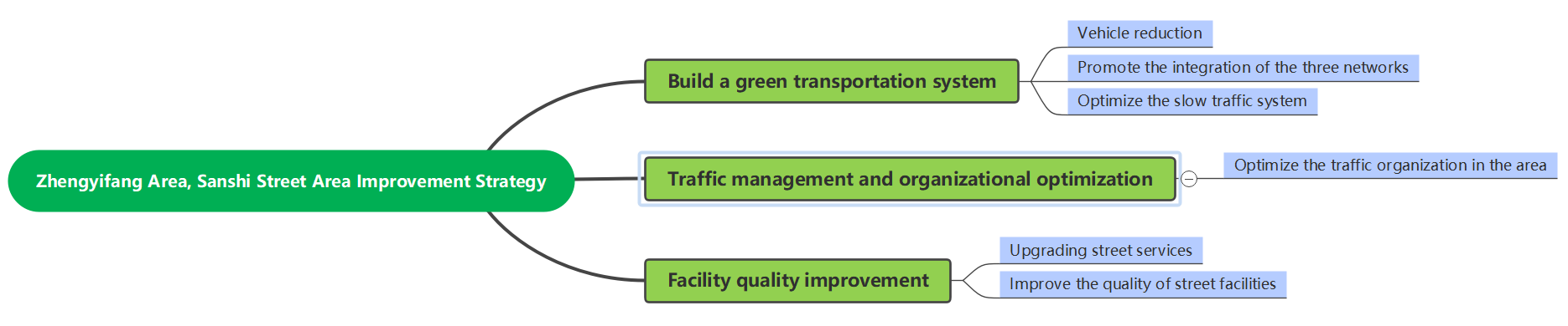
Figure 5. Design ideas
3.2. Wuhua District Zhengyi Road Area and Sanshi Street Area Improvements
3.2.1. Field survey and status analysis. Conducted a field survey of the Zhengyi Road and Sanshi Street areas in the core area of Wuhua District, Kunming, to obtain detailed data on public transportation resources, completion of the road network and level of service, non-motorized parking locations, motorized vehicle parking information, information on pedestrian entrances and exits and signage, and slow-moving systems.
Relevant traffic characteristics and issues, such as traffic congestion, parking difficulty, and pedestrian access, are collected through field observations.
Analyze the traffic planning and management experience of famous pedestrian street areas at home and abroad, explore their successful practice cases, and gain a deeper understanding of their traffic organization, public transport services, street space quality and other characteristics.
Draw lessons from the traffic management experience of advanced foreign cities and understand their implementation strategies and technical means for pedestrian street upgrading and transformation. Such as adopting differentiated, flexible traffic management methods by mode and time, congestion charging and other measures.
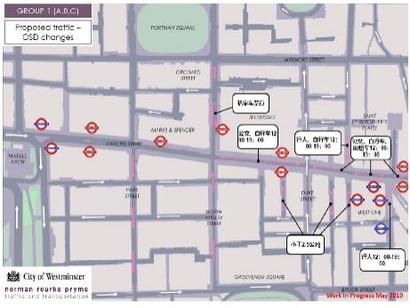
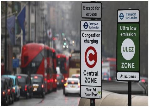
(1) Take Oxford Street in London as an example, such as in Figure 6 and Figure 7. According to the characteristics of the pedestrian flow in the neighborhood, it has adopted a differentiated and flexible traffic management approach in both the main street and the secondary street in terms of modes and time periods, effectively expanding the pedestrian priority area in the hot spot concentration area, maximizing the protection of the right of way for pedestrians, and at the same time, trying to make it possible to facilitate the passage of public transport and bicycle traffic, combining with Each intersection and road section is upgraded to provide a safe and comfortable street walking environment.
Congestion Charging Zone According to Transport for London, vehicles traveling in the Congestion Charging Zone pay £15 per day from 7a.m, to 6p.m. on weekdays and from 12p.m. to 6p.m. on weekends and bank holidays, except on Christmas Day and New Year's Day. Residents within the congestion zone who are 17 years of age or older are entitled to a 90% congestion discount. In addition, vehicles with more than nine seats, urban cleaning vehicles, small tricycles, roadside assistance vehicles, ambulances and fire engines, and vehicles used by disabled people are exempt from the Congestion Charge [5].
|
|
Figure 6. London Congestion Zone logo | Figure 7. London Congestion Zone logo |
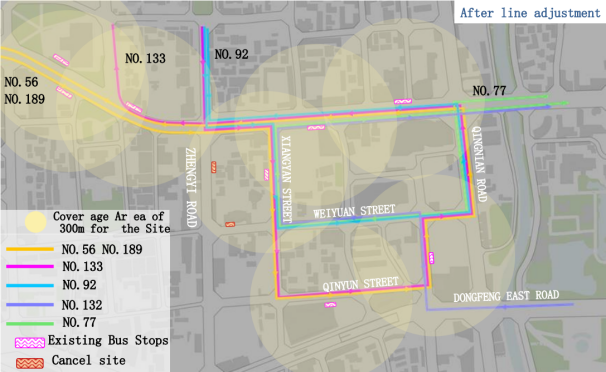
(2) Build the integration of rail and bus, optimize the direction of bus routes, increase the connection between bus routes and rail, and increase the connection between bus stops and rail.
Impact site: Zhengyi Road Pedestrian Station, Weiyuan Street Station, 6 bus routes, peak hourly bus traffic of 180 passengers; to solve the problem, the bus can be reached as the focus, and to ensure the level of public transport services, the original Zhengyi Road south to north bus service lines are evacuated to the youth road for the organization, such as Figure 8, Figure 9.
|
|
Figure 8. Zhengyi Road: the original north-south bus service line | Figure 9. Optimized line. |
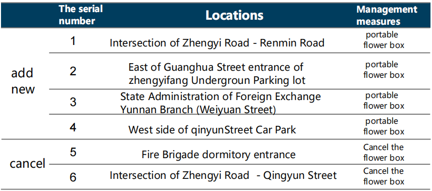
(3) Create characteristic slow-travel routes: create a high-quality walking environment in the area, with Nanping Street and Zhengyi Road Pedestrian Street as the skeleton, and transform Zhengyi Road into a pedestrian street, to set up removable flower boxes, shown in Figure 10 and Figure 11. Implement a differentiated traffic organization for time periods, with parking or loading/unloading of passengers and goods prohibited during the business hours of 7 a.m. to 12 a.m. Combine the peripheral pedestrian corridors to connect cultural attractions, commercial centers, and recreational parks to create distinctive pedestrian routes that reflect the atmosphere of the historic district. Due to the addition of a new pedestrian street, local adjustments to the traffic organization are required. Solutions involving motorized entrances and exits of buildings along the route.
|
|
Figure 10. Pedestrian traffic organization optimization measures | Figure 11. Corresponding position |
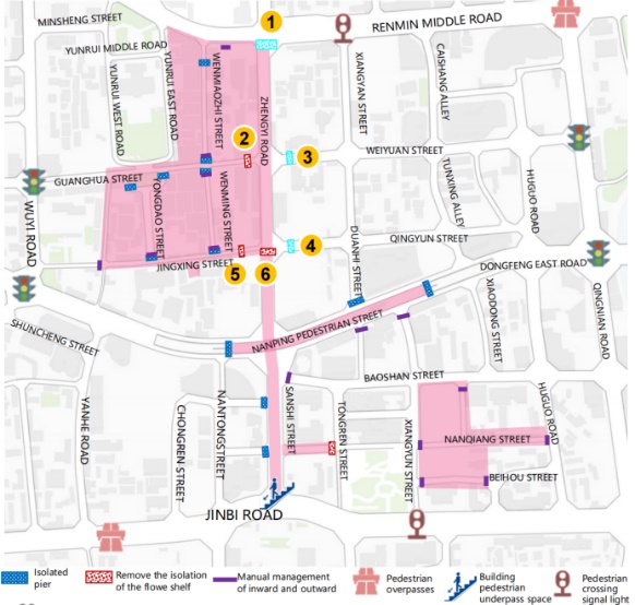
Close the Xiangyan Street pedestrian crossing: Detour through the Zhengyi Road intersection, cancel the signal lights, and reduce the impact on the main line of Renmin Road traffic.
Enhance parking enforcement, for this micro-circulation road; illegal parking behavior and violations of retrograde behavior will be severely punished. Installation of directional signs: upgrade the installation of directional signs at the intersection of Weiyuan Street-Elephant Eye Street and Qingyun Street-Elephant Eye Street, reminding vehicles that Zhengyi Road is a pedestrian street in front of them, which is prohibited for motorized vehicles, and requesting them to make detours in advance.
(4) Strengthen the management of non-motorized on-street parking. To first delineate the no-traffic area, the demonstration area is divided into the core walking area and the demonstration of the peripheral area. The core walking area to create a "public transportation+ walking" travel system, prohibit non-motorized vehicles into. The peripheral areas of the demonstration zone will be divided into the core pedestrian zone and the peripheral areas of the demonstration zone.
Control the total amount of placement: strengthen the limitations on the number of shared bicycles placed in the area, and control it within 3,000.
Delineation of no-traffic zones: The demonstration area is divided into the core pedestrian zone and the peripheral zone of the demonstration area. The core pedestrian zone will be divided into the core pedestrian zone and the peripheral zone. The peripheral area of the demonstration zone will create a "public transportation + bicycle + walking" travel system, with electronic fences and a "parking in the fence" parking layout for bicycles.
Regulate parking spaces: 52 non-motorized parking frames are set up around the sub-branch road road side facilities belt and the main road subway station, with a total parking area of about 3,900 square meters, which can meet the parking demand of 1,900 electric bicycles (or 5,200 shared bicycles). According to the non-motorized travel sharing ratio of the area, 1,250 electric bicycles + 1,870 shared bicycles can be parked. The rest of the e-bikes are parked in the plot-allocated e-bike parking spaces.
Increase penalties: strengthen the shared bicycle, private non-motorized vehicle indiscriminate parking penalties, in the integrity file.
(5)Improvement of irregular parking, introduction of intelligent traffic management, intelligent parking, and improvement of traffic efficiency [6]. The establishment of parking guidance, parking berth sharing system, improve the utilization rate of parking spaces in the area. In the key units (into the bank, school, market, etc.) to set up a small number of harbor type temporary parking spaces with limited parking, building front area public space optimization.
(6)Expansion of the pedestrian zone: adding "three horizontal and one vertical" pedestrian streets.
Adjust Zhengyi Road (Qingyun Street-People's Road), the whole line of Jingxing Street, Nanqiang Street, and Fulin Plaza as pedestrian streets, totaling 1.6km, and the size of the pedestrian street in the area after adjustment reaches 3.9km.
4. Innovative features
(1) Helping to create a low-carbon green transportation demonstration area, innovative establishment of the "current situation survey - traffic characteristics and problems - case studies - planning strategies - program measures" technical line of work.
(2) For the first time in Kunming, a core green and low-carbon demonstration zone has been created in the city's core area, with "individual motorization reduction + green increment" as its core. By coordinating multiple systems such as slow-moving transportation, public transportation, non-motorized vehicles, motorized vehicles, and street space quality, the city promotes the integration of three networks, namely, "rail transportation network, conventional bus network, and slow-moving transportation network" [7]. To establish a "public transportation + slow-moving" travel system, and guide the public to give priority to public transportation, walking, cycling and other green travel modes [8]. The project is a demonstration of "green mobility" in the core area of Kunming.
(3) Adhering to the concept of "people-oriented" planning, purifying street space and comprehensively upgrading the quality of street space. Following the idea of changing from "car-oriented" to "people-oriented", this paper proposes a strategy that is compatible with the commercial, historical and cultural neighborhoods in the district. First, through the addition of "three horizontal and one vertical" pedestrian streets, to "line" connect "piece" to create a core pedestrian street area, improve the carrying capacity of pedestrian street traffic. Secondly, optimize the connection between the pedestrian street and the surrounding road slow-moving system, so as to realize the separation of pedestrian and vehicular traffic. Third, comprehensively clean up the front area of the building and the road surface of the illegal parking of motor vehicles, standardize the management of non-motorized vehicles, purify the street space walking quality, and so on.
5. Conclusion
This study explores the design and implementation strategies of an urban low-carbon transportation demonstration zone in the Wuhua District of Kunming, in the context of "dual-carbon", in the area of Zhengyi Road and Sanshi Street. Through a detailed analysis of the current traffic situation in the area, and combining successful cases at home and abroad, this paper proposes a series of innovative and operable low-carbon transportation improvement measures. (1) By optimizing public transport services, it aims to improve the coverage and convenience of bus routes and increase the seamless connection between public transport and rail transit in order to reduce the frequency of private car use, thereby reducing traffic congestion and carbon emissions. (2) With regard to the improvement of pedestrian precincts, emphasis has been placed on installing more slow-moving facilities, optimizing the walking environment, ensuring pedestrian safety, and enhancing the comfort and attractiveness of walking. This not only helps reduce carbon emissions, but also enhances the livability of the city. (3) A strategy for regulating and managing non-motorized vehicles is proposed to ensure the reasonable use of slow-moving space through the designation of special non-motorized parking areas and the strict management of non-motorized parking behaviors, so as to create an orderly and safe traffic environment. (4) Introducing an intelligent traffic management system, utilizing advanced technological means for dynamic traffic management, establishing an intelligent parking system, and improving the efficiency of traffic management. This will not only effectively alleviate traffic congestion, but also provide the public with a more convenient traveling experience. (5) By enhancing policy support and public participation, we hope to raise the public's awareness of green mobility and encourage the public to actively participate in the construction and maintenance of the low-carbon transportation demonstration zone. This strategy requires not only the guidance and support of the government, but also extensive public participation and cooperation.
Although this study proposes a series of specific implementation measures, it still faces many challenges in its actual operation. Future research should further explore issues in terms of policy support and implementation pathways, public participation and behavioral guidance, technological innovation and application, as well as long-term effect evaluation and feedback.
References
[1]. Opinions of the Central Committee of the Communist Party of China and the State Council on Complete and Accurate Comprehensive Implementation of the New Development Idea and Doing a Good Job in Carbon Peak and Carbon Neutrality[C]// Blue Book of China Enterprise Reform and Development 2021. [Publisher unknown], 2021:6.
[2]. Opinions of the CPC Central Committee and State Council on deepening the battle against pollution [N]. People's Daily,2021-11-08(001). DOI:10.28655/n.cnki.nrmrb.2021.011759.
[3]. Yin Fou, Mei Shen. Green transportation standard system release system planning transportation green low-carbon standardization development[J]. Waterways and Ports,2022,43(04):560.
[4]. Zicheng Li, Jue Wang. Green Transportation and Urban Sustainable Development-An Assessment of the Policy Effect of Low-Carbon Transportation System Pilot Based on Spatial Double Difference [J/OL]. Journal of Lanzhou University of Finance and Economics:1-16 [2024-07-05]. http://kns.cnki.net/kcms/detail/62.1213.f.20240315.1611.016.html.
[5]. Song Gao, Dong Wang, Xiaoli Sun, et al. Traffic Environment Improvement of Commercial Pedestrian Street in Historical Neighborhoods--Taking Jianghan Road Pedestrian Street in Wuhan as an Example [C]// Academic Committee of Urban Transportation Planning, China Society of Urban Planning. Wuhan Institute of Transportation Development Strategy, 2022:17. DOI:10.26914/c.cnkihy.2022.059256.
[6]. Zhirong Ye. Organic Regeneration of Transportation in the Context of Urban Renewal in Core Areas [J]. Shanghai Highway, 2024(02):215-220+260.
[7]. Xuedan Zhang, Lizhen Li, Xinhui Wang, et al. Spatial Planning Research on Slow Traffic on Urban Branch Roads Based on Dense Road Network [C]// 2022 Annual Conference on Urban Transportation Planning in China. [Publisher unknown], 2022:16.DOI:10.26914/c.cnkihy.2022.059205.
[8]. Guan Zhen. Research on Rail Transit Interchange Planning Based on "Three-Network Integration" [C]//The Annual Conference on Urban Transportation Planning in China 2021/2022. [Publisher unknown], 2022:9. DOI:10.26914/c.cnkihy.2022.059162.
Cite this article
Yan,J. (2024). Design of urban low-carbon green transportation demonstration area in the context of "dual carbon" -- Taking Wuhua District of Kunming City (Zhengyi Road and Sanshi Street area) as an example and Sanshi Street area) as an example. Applied and Computational Engineering,91,54-62.
Data availability
The datasets used and/or analyzed during the current study will be available from the authors upon reasonable request.
Disclaimer/Publisher's Note
The statements, opinions and data contained in all publications are solely those of the individual author(s) and contributor(s) and not of EWA Publishing and/or the editor(s). EWA Publishing and/or the editor(s) disclaim responsibility for any injury to people or property resulting from any ideas, methods, instructions or products referred to in the content.
About volume
Volume title: Proceedings of the 2nd International Conference on Functional Materials and Civil Engineering
© 2024 by the author(s). Licensee EWA Publishing, Oxford, UK. This article is an open access article distributed under the terms and
conditions of the Creative Commons Attribution (CC BY) license. Authors who
publish this series agree to the following terms:
1. Authors retain copyright and grant the series right of first publication with the work simultaneously licensed under a Creative Commons
Attribution License that allows others to share the work with an acknowledgment of the work's authorship and initial publication in this
series.
2. Authors are able to enter into separate, additional contractual arrangements for the non-exclusive distribution of the series's published
version of the work (e.g., post it to an institutional repository or publish it in a book), with an acknowledgment of its initial
publication in this series.
3. Authors are permitted and encouraged to post their work online (e.g., in institutional repositories or on their website) prior to and
during the submission process, as it can lead to productive exchanges, as well as earlier and greater citation of published work (See
Open access policy for details).
References
[1]. Opinions of the Central Committee of the Communist Party of China and the State Council on Complete and Accurate Comprehensive Implementation of the New Development Idea and Doing a Good Job in Carbon Peak and Carbon Neutrality[C]// Blue Book of China Enterprise Reform and Development 2021. [Publisher unknown], 2021:6.
[2]. Opinions of the CPC Central Committee and State Council on deepening the battle against pollution [N]. People's Daily,2021-11-08(001). DOI:10.28655/n.cnki.nrmrb.2021.011759.
[3]. Yin Fou, Mei Shen. Green transportation standard system release system planning transportation green low-carbon standardization development[J]. Waterways and Ports,2022,43(04):560.
[4]. Zicheng Li, Jue Wang. Green Transportation and Urban Sustainable Development-An Assessment of the Policy Effect of Low-Carbon Transportation System Pilot Based on Spatial Double Difference [J/OL]. Journal of Lanzhou University of Finance and Economics:1-16 [2024-07-05]. http://kns.cnki.net/kcms/detail/62.1213.f.20240315.1611.016.html.
[5]. Song Gao, Dong Wang, Xiaoli Sun, et al. Traffic Environment Improvement of Commercial Pedestrian Street in Historical Neighborhoods--Taking Jianghan Road Pedestrian Street in Wuhan as an Example [C]// Academic Committee of Urban Transportation Planning, China Society of Urban Planning. Wuhan Institute of Transportation Development Strategy, 2022:17. DOI:10.26914/c.cnkihy.2022.059256.
[6]. Zhirong Ye. Organic Regeneration of Transportation in the Context of Urban Renewal in Core Areas [J]. Shanghai Highway, 2024(02):215-220+260.
[7]. Xuedan Zhang, Lizhen Li, Xinhui Wang, et al. Spatial Planning Research on Slow Traffic on Urban Branch Roads Based on Dense Road Network [C]// 2022 Annual Conference on Urban Transportation Planning in China. [Publisher unknown], 2022:16.DOI:10.26914/c.cnkihy.2022.059205.
[8]. Guan Zhen. Research on Rail Transit Interchange Planning Based on "Three-Network Integration" [C]//The Annual Conference on Urban Transportation Planning in China 2021/2022. [Publisher unknown], 2022:9. DOI:10.26914/c.cnkihy.2022.059162.