


1. Introduction
Low-temperature rain, snow, and ice disasters, as prevalent extreme meteorological phenomena, exert a profound impact on human societal production and daily life. Such calamities are often accompanied by extensive low temperatures, snowfall, and freezing conditions, leading to a cascade of issues including transportation disruptions, damage to power infrastructure, and crop devastation. In this context, achieving efficient disaster monitoring and assessment has become a critical issue for nations grappling with climate change and extreme weather challenges. Traditional monitoring methods, such as satellite remote sensing and ground observation stations, while advantageous in large-scale data collection and long-term monitoring, still fall short in addressing the timeliness of sudden disasters [1]. The advent of drone remote sensing systems has brought a new breakthrough in monitoring low-temperature rain, snow, and ice disasters. With their agile flight capabilities, high-resolution imaging, and real-time data transmission, drones can be swiftly deployed to collect disaster information even under harsh weather conditions, significantly enhancing monitoring efficiency and accuracy [2]. This article aims to explore the effectiveness of drone remote sensing systems in monitoring low-temperature rain, snow, and frost-related disasters, as well as the challenges they encounter. The research questions focus on enhancing the performance stability of drone systems under extreme low-temperature conditions and optimizing data processing workflows to improve the timeliness and accuracy of disaster monitoring. Theoretically, this study will advance the application research of drone remote sensing technology in extreme climatic conditions, enrich the theoretical framework of disaster monitoring, and provide a scientific foundation for the future development of related technologies.
2. Composition and working principles of UAV remote sensing system
The composition and operational principles of drone remote sensing systems are pivotal to their significant role in disaster monitoring.
Typically, a drone remote sensing system comprises several components: the flight platform, remote sensing sensors, data processing modules, and communication systems. The flight platform determines the drone's maneuverability, flight duration, and stability; the sensors encompass optical cameras, infrared thermal imagers, multispectral, and hyperspectral sensors, capable of capturing information across various spectral bands, thereby ensuring the acquisition of crucial disaster data under diverse weather conditions. Figure 1 illustrates the fundamental structure of the drone system. The data processing module facilitates the real-time processing of images and signals collected during flight, producing remote sensing data that is ready for analysis. The communication system is responsible for transmitting the gathered data back to the ground command center, enabling real-time monitoring.
The operational principles of the drone remote sensing system hinge on the agility of the flight platform and the efficient data acquisition capabilities of the sensors. By controlling flight altitude and routes, the system can observe target areas from multiple angles, particularly in scenarios involving low-temperature, rain, snow, or freezing disasters, where traditional monitoring equipment may struggle to reach or function effectively. The system's real-time capabilities and high-resolution proficiency allow for rapid and accurate assessments of the impact of disasters on the environment, thereby providing timely information to decision-makers. The strength of the drone remote sensing system lies in its high degree of integration, combining sophisticated sensor technologies with automated flight systems to facilitate swift scanning and monitoring of disaster-affected areas. As technology advances, improvements in the endurance, cold resistance, and sensor precision of drones continue to enhance their feasibility and reliability in extreme climatic conditions [3].
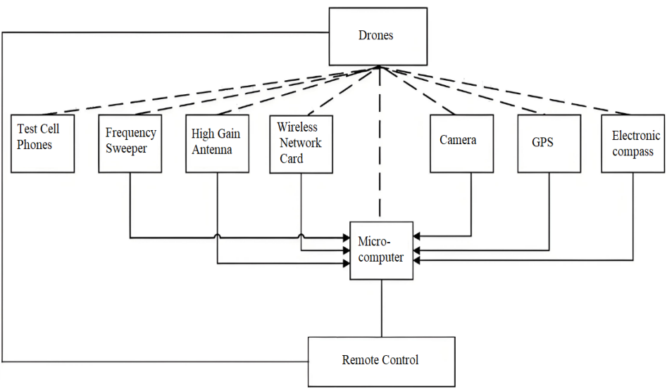
Figure 1: Basic structure of the UAS.
3. Application measures of UAV remote sensing system in disaster monitoring
3.1. Data acquisition
In the realm of monitoring low-temperature precipitation and ice storm disasters, data acquisition stands as the foremost step in the application of unmanned aerial vehicle (UAV) remote sensing systems, serving as a fundamental element within the entire disaster assessment chain. UAVs are equipped with a variety of sensors, capable of capturing an extensive array of multidimensional data across domains such as optical, infrared, and lidar. The frigid environment imposes heightened demands on data collection; the sensors aboard the aircraft must possess cold-resistant capabilities to function continuously under harsh conditions.
The precision and comprehensiveness of the data collection process directly influence the quality of subsequent disaster assessments. Under complex meteorological conditions, particular attention must be paid to flight altitude, speed, and flight path design. Icy and snowy weather often results in reduced visibility, rendering the UAV's autonomous flight capabilities and obstacle avoidance technologies critically important. Adjusting flight parameters flexibly enables the UAV to still acquire high-quality remote sensing data amidst severe conditions [4]. For instance, lidar can penetrate snow cover to perform high-precision terrain scans even under low visibility, while infrared sensors are adept at detecting temperature variations and the extent of freezing.
3.2. Data processing and analysis
In the monitoring of severe cold, snow, and ice disasters, the processing and analysis of data are pivotal factors in determining the practical effectiveness of unmanned aerial vehicle (UAV) remote sensing systems. Given the UAV's capability to collect vast amounts of multisource data within a short period, the challenge of efficiently processing and extracting useful information from this data set has become a critical issue in disaster monitoring and emergency response. The complex terrain and dynamic changes associated with ice disasters make precise data analysis particularly crucial. Data processing typically involves the preliminary handling and multisource fusion of data collected by various types of sensors, including optical images, infrared images, and Light Detection and Ranging (LiDAR) data. During this process, it is essential to fully account for the impact of low temperatures and complex weather conditions on data quality. Advanced image processing algorithms are employed to filter out noise and interference, and the raw data is corrected and registered. This ensures the accuracy and consistency of the data, providing a reliable foundation for subsequent disaster assessments [5].
The analysis phase focuses on identifying the affected areas, assessing the extent of damage, and predicting the further development of the disaster. Modern data analysis techniques, such as machine learning and big data processing, can extract valuable patterns and trends from massive data sets in a short time. For instance, infrared sensor data can help identify heat loss in cold environments, while LiDAR can accurately assess snow depth and terrain changes [6]. Through these analyses, command centers can make rapid decisions and deploy resources to respond to disasters effectively. The efficiency of UAV data processing and analysis directly influences the speed and accuracy of disaster response. With the continuous advancement of technology, automated processing and intelligent analytical methods will significantly enhance the application of UAV remote sensing systems in the monitoring of severe cold, snow, and ice disasters, thereby providing stronger support for disaster management.
3.3. Real-time monitoring and early warning
In the monitoring of low-temperature rain, snow, and ice disasters, the real-time monitoring and early warning capabilities of drone remote sensing systems are undoubtedly among its most critical applications. This function enables the dynamic updating of disaster conditions through instantaneous data collection and transmission, thereby providing timely information for emergency decision-making. In extreme weather conditions such as low-temperature freezing, traditional monitoring methods often fail to reach affected areas swiftly, and satellite monitoring is constrained by orbital limitations, lacking flexibility. The agility and real-time data transmission advantages of drones allow them to serve as vital tools for immediate monitoring during a disaster. The essence of real-time monitoring lies in the various sensors mounted on the drones, which can simultaneously capture multidimensional information and transmit it to ground control centers via high-speed data links. Particularly during freezing disasters, real-time data can help identify the expansion trends of frozen areas and promptly detect potential hazards, such as icing on power lines or snow accumulation on roads, which is crucial for preventing secondary disasters.
In terms of early warning, drones can provide predictive insights during the initial and spreading phases of a disaster through continuous data updates. By analyzing real-time data in conjunction with historical data and model simulations, early warning systems can preemptively identify high-risk areas or deteriorating disaster conditions, thus issuing timely alerts. Such early warning capabilities not only assist various management levels in deploying rescue forces in advance but also reduce losses of life and property. The real-time monitoring and early warning functions of drone remote sensing systems not only enhance the timeliness of disaster monitoring but also offer efficient technical support for disaster prevention and mitigation [7].
4. Technical and management measures
4.1. Low-temperature resistant design and performance optimization of equipment
In the realm of low-temperature monitoring of rain, snow, and ice disasters, the design and performance optimization of drones to withstand frigid conditions are pivotal to ensuring their effective operation. Cold environments present formidable challenges to the various components of drones, particularly affecting battery performance, sensor stability, and the reliability of flight control systems. In extremely cold conditions, the endurance of conventional drone batteries significantly diminishes, resulting in reduced flight time, while the sensitivity and accuracy of sensors are also susceptible to degradation. This poses a challenge for continuous monitoring and data collection in disaster-stricken areas.
To address these issues, the low-temperature design of drone equipment must be optimized across multiple facets, including materials, structure, and energy management. The battery system, as the core power source of a drone, is particularly crucial. In cold conditions, the viscosity of the electrolyte in lithium batteries increases, and the rate of electrochemical reactions slows down, leading to a substantial decrease in battery discharge efficiency. Therefore, the development of low-temperature-resistant batteries has become a key focus in optimizing drone performance. Currently, high-energy-density solid-state batteries or heating systems can significantly enhance battery endurance in low temperatures, ensuring stable flight in extreme environments. Similarly, optimizing sensors is essential. Cold temperatures can cause sensor components to malfunction or yield measurement errors; thus, selecting materials and packaging processes with excellent cold resistance is imperative. Infrared sensors, LiDAR, and other devices require specially designed operating temperature ranges to ensure high-quality data collection under extreme conditions. Furthermore, timely sensor recalibration and fault diagnosis can further enhance data precision and reliability. The flight control system of the drone must also adapt to changes in low-temperature conditions. As temperatures plummet, the increased air density affects the lift and maneuverability of the aircraft; thus, flight control algorithms must dynamically adjust flight posture and speed based on environmental parameters to maintain stability. Heating systems and anti-icing technologies should be applied to critical mechanical components, such as motors and propellers, to prevent ice and snow accumulation that could compromise flight safety.
Through the integration and optimization of these technological measures, drones can operate more efficiently in low-temperature rain, snow, and ice environments, enhancing the precision of disaster monitoring and the reliability of emergency responses. Low-temperature design is not only a hardware enhancement but a necessary condition for drones to achieve sustained and stable operation in extreme environments. These improvements lay a solid foundation for the extensive application of drones in disaster monitoring and signify the further maturation of drone technology in complex environments [8].
4.2. Formulating standard operating procedures for remote sensing monitoring by drones
In the context of low-temperature, rain, snow, and freezing disasters, establishing a Standard Operating Procedure (SOP) for drone remote sensing monitoring is crucial to ensuring the smooth execution of monitoring tasks. This procedure's formulation concerns not only the technical specifications of the equipment but also the coordination and unification of operational processes, data handling, and emergency response plans. Monitoring disasters in low-temperature environments often presents complexity and urgency; without systematic and standardized operational guidelines, the effectiveness of monitoring may diminish, potentially resulting in greater resource wastage or erroneous judgments.
Firstly, the essence of the SOP is to ensure the safety and efficacy of drone operations. In low-temperature environments, the difficulty of operating drones increases significantly, raising the risk of flight. Consequently, the operational procedures need to clearly stipulate pre-flight preparations, such as battery condition checks, sensor calibrations, and system warm-ups, to mitigate the potential impacts of low temperatures on the equipment.
Additionally, operators must possess the skills and experience to handle drones under adverse weather conditions, particularly to make swift decisions in unexpected situations during flight to avoid equipment damage or monitoring failures. The SOP should encompass detailed processes for data collection and processing. Data collected during low-temperature, rain, snow, and freezing disasters is often complex and diverse, involving the fusion and analysis of data from various sensors. To ensure data accuracy and consistency, the SOP should specify the collection steps and timing for each type of data, avoiding discrepancies or omissions that could distort analytical results.
Furthermore, regulations regarding data transmission and storage should be included to maintain the timeliness and security of disaster monitoring information. Emergency response plans are a vital component of the SOP. Disaster monitoring typically occurs in high-uncertainty environments where sudden issues such as equipment malfunctions, communication disruptions, or deteriorating weather conditions may impact task progress. Developing emergency response procedures can effectively minimize the impact of such incidents. For example, in cases of battery depletion or turbulence, the SOP should delineate emergency return routes and safe landing site choices to ensure maximum equipment safety and data integrity. Standardized operational procedures not only enhance the efficiency of drone remote sensing systems in disaster monitoring but also reduce human error, ensuring smooth coordination across various stages [9].
4.3. Strengthening the professional training of drone operators and data analysts
In the context of low-temperature, rain, snow, and ice-related disasters, enhancing the professional training of drone operators and data analysts has become crucial to ensuring the efficient operation of drone remote sensing systems.
Both the operation of drones and the analysis of remote sensing data require a high degree of specialized skills, particularly when applied in extreme environments, necessitating comprehensive and multi-faceted training to address complex disaster scenarios. Training for operators extends beyond mere basic flight control; it is imperative to master how to maintain the drone's safety and stability under frigid and adverse weather conditions. Extreme cold environments impose unique demands on drone equipment, such as reduced battery life and sensor malfunctions. Operators must not only be adept at piloting drones but also possess the capability to manage extreme conditions, such as assessing whether environmental conditions are suitable for takeoff and maintaining flight stability amidst sudden gusts or snow accumulation. Such high-level operational proficiency cannot be solely acquired through theoretical training but requires practical drills in simulated or real extreme climates to enhance emergency response skills.
Simultaneously, the training of data analysts is equally critical in disaster monitoring. The data collected by drone remote sensing systems during low-temperature, rain, snow, and ice-related disasters often comprises vast amounts of remote sensing imagery, LiDAR data, temperature, and humidity information, which demands higher standards of data processing and analysis. Analysts must be skilled in integrating and interpreting multi-source data and using specialized software for precise analysis. For instance, they need to identify frozen areas from imagery, predict disaster expansion trends based on real-time monitoring data, and provide scientific bases for decision-makers through data modeling. The timeliness of data analysis is crucial in disaster emergency monitoring; hence, analysts must not only master data processing techniques but also possess the ability to quickly assess and respond to complex data. Furthermore, the content of professional training should encompass interdisciplinary knowledge integration. Drone remote sensing technology involves not only flight control and data processing but also fundamental knowledge from meteorology, geology, and related fields. Operators and data analysts need to understand the basic principles of disaster types, such as the impact of low-temperature rain, snow, and ice on terrain and meteorological features under freezing conditions [10].
5. Conclusion
This article explores the application of drone remote sensing systems in the monitoring of low-temperature rain, snow, and freezing disasters, affirming the efficiency and applicability of drone technology, particularly in data collection, real-time monitoring, and early warning systems. Drones are capable of providing timely, high-resolution monitoring data and exhibit significant advantages over traditional monitoring methods in terms of rapid response and coverage. However, the stability of drone systems under extreme climatic conditions and the data processing technologies still require improvement. Moreover, due to limited resources and field testing scopes, future research should broaden the geographical range and climatic conditions for data collection to enhance the universality of the study. Although this article discusses the challenges associated with data processing, it lacks specific algorithm optimization or technical details; future advancements could enhance analytical precision and speed through the development of more efficient data processing algorithms. Subsequent research may focus on several aspects: firstly, the creation of drone hardware and materials that are suited for extreme low-temperature environments, such as cold-resistant batteries and sensors; secondly, the refinement of data processing algorithms, especially leveraging artificial intelligence and machine learning technologies to elevate the automation and intelligence of data analysis; thirdly, the exploration of integrative applications of drones with satellite remote sensing and ground monitoring systems to establish a multi-source data fusion disaster monitoring framework; lastly, the enhancement of training for drone operators, particularly their decision-making capabilities in the face of extreme weather conditions and emergencies. Through such research endeavors, drone remote sensing technology is poised to play a more significant role in disaster monitoring and management, providing robust technological support to confront the challenges posed by climate change.
References
[1]. Gaffey C, Bhardwaj A. Applications of unmanned aerial vehicles in cryosphere: Latest advances and prospects[J]. Remote Sensing, 2020, 12(6): 948.
[2]. Wang X, e H. A review on applications of remote sensing and geographic information systems (GIS) in water resources and flood risk management[J]. Water, 2018, 10(5): 608.
[3]. Acharya B S, Bhandari M, Bandini F, et al. Unmanned aerial vehicles in hydrology and water management: Applications, challenges, and perspectives[J]. Water Resources Research, 2021, 57(11): e2021WR029925.
[4]. Villa T F, Gonzalez F, Miljievic B, et al. An overview of small unmanned aerial vehicles for air quality measurements: Present applications and future prospectives[J]. Sensors, 2016, 16(7): 1072.
[5]. Bhardwaj A, Sam L, Martín-Torres F J, et al. UAVs as remote sensing platform in glaciology: Present applications and future prospects[J]. Remote sensing of environment, 2016, 175: 196-204.
[6]. Verfaillie M, Cho E, Dwyre L, et al. UAS remote sensing applications to abrupt cold region hazards[J]. Frontiers in Remote Sensing, 2023, 4: 1095275.
[7]. Hildmann H, Kovacs E. Using unmanned aerial vehicles (UAVs) as mobile sensing platforms (MSPs) for disaster response, civil security and public safety[J]. Drones, 2019, 3(3): 59.
[8]. Asadzadeh S, de Oliveira W J, de Souza Filho C R. UAV-based remote sensing for the petroleum industry and environmental monitoring: State-of-the-art and perspectives[J]. Journal of Petroleum Science and Engineering, 2022, 208: 109633.
[9]. Lampert A, Altstädter B, Bärfuss K, et al. Unmanned aerial systems for investigating the polar atmospheric boundary layer—Technical challenges and examples of applications[J]. Atmosphere, 2020, 11(4): 416.
[10]. Tripp D D, Martin E R, Reeves H D. Applications of uncrewed aerial vehicles (UAVs) in winter precipitation-type forecasts[J]. Journal of Applied Meteorology and Climatology, 2021, 60(3): 361-375.
Cite this article
Ma,M. (2025). Application of Unmanned Aerial Vehicle Remote Sensing System in Low Temperature Rain, Snow and Ice Disaster Monitoring. Applied and Computational Engineering,126,102-108.
Data availability
The datasets used and/or analyzed during the current study will be available from the authors upon reasonable request.
Disclaimer/Publisher's Note
The statements, opinions and data contained in all publications are solely those of the individual author(s) and contributor(s) and not of EWA Publishing and/or the editor(s). EWA Publishing and/or the editor(s) disclaim responsibility for any injury to people or property resulting from any ideas, methods, instructions or products referred to in the content.
About volume
Volume title: Proceedings of the 5th International Conference on Materials Chemistry and Environmental Engineering
© 2024 by the author(s). Licensee EWA Publishing, Oxford, UK. This article is an open access article distributed under the terms and
conditions of the Creative Commons Attribution (CC BY) license. Authors who
publish this series agree to the following terms:
1. Authors retain copyright and grant the series right of first publication with the work simultaneously licensed under a Creative Commons
Attribution License that allows others to share the work with an acknowledgment of the work's authorship and initial publication in this
series.
2. Authors are able to enter into separate, additional contractual arrangements for the non-exclusive distribution of the series's published
version of the work (e.g., post it to an institutional repository or publish it in a book), with an acknowledgment of its initial
publication in this series.
3. Authors are permitted and encouraged to post their work online (e.g., in institutional repositories or on their website) prior to and
during the submission process, as it can lead to productive exchanges, as well as earlier and greater citation of published work (See
Open access policy for details).
References
[1]. Gaffey C, Bhardwaj A. Applications of unmanned aerial vehicles in cryosphere: Latest advances and prospects[J]. Remote Sensing, 2020, 12(6): 948.
[2]. Wang X, e H. A review on applications of remote sensing and geographic information systems (GIS) in water resources and flood risk management[J]. Water, 2018, 10(5): 608.
[3]. Acharya B S, Bhandari M, Bandini F, et al. Unmanned aerial vehicles in hydrology and water management: Applications, challenges, and perspectives[J]. Water Resources Research, 2021, 57(11): e2021WR029925.
[4]. Villa T F, Gonzalez F, Miljievic B, et al. An overview of small unmanned aerial vehicles for air quality measurements: Present applications and future prospectives[J]. Sensors, 2016, 16(7): 1072.
[5]. Bhardwaj A, Sam L, Martín-Torres F J, et al. UAVs as remote sensing platform in glaciology: Present applications and future prospects[J]. Remote sensing of environment, 2016, 175: 196-204.
[6]. Verfaillie M, Cho E, Dwyre L, et al. UAS remote sensing applications to abrupt cold region hazards[J]. Frontiers in Remote Sensing, 2023, 4: 1095275.
[7]. Hildmann H, Kovacs E. Using unmanned aerial vehicles (UAVs) as mobile sensing platforms (MSPs) for disaster response, civil security and public safety[J]. Drones, 2019, 3(3): 59.
[8]. Asadzadeh S, de Oliveira W J, de Souza Filho C R. UAV-based remote sensing for the petroleum industry and environmental monitoring: State-of-the-art and perspectives[J]. Journal of Petroleum Science and Engineering, 2022, 208: 109633.
[9]. Lampert A, Altstädter B, Bärfuss K, et al. Unmanned aerial systems for investigating the polar atmospheric boundary layer—Technical challenges and examples of applications[J]. Atmosphere, 2020, 11(4): 416.
[10]. Tripp D D, Martin E R, Reeves H D. Applications of uncrewed aerial vehicles (UAVs) in winter precipitation-type forecasts[J]. Journal of Applied Meteorology and Climatology, 2021, 60(3): 361-375.