


1. The Evolution and Challenges of the Metropolitan Green Belt in London
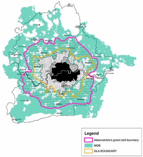
Figure 1: The metropolitan green belt in London.
The urban green belt is one of the important urban planning tools widely used in various socio-economic and cultural contexts since World War II [1]. Taking the Metropolitan Green Belt in London, United Kingdom as an example, it was established in the 1930s with the original function of serving as the city’s green lung and providing natural spaces for leisure and recreation for urban residents [2]. It is evident that the development of the urban green belt is closely related to the relationship between urban green spaces and urban living spaces. However, over the past few decades, the highly restrictive nature of the Green Belt policy in London has gradually intensified the dichotomy between living environments and natural surroundings, posing challenges to urban development.
1.1. The Evolving Restrictiveness of the Green Belt Policy in London
The concept of the green belt first appeared in the process of constructing the garden city of Letchworth in 1909, referring to the buffer zone primarily composed of farmland between cities and serving the purpose of supplying agricultural products to the urban area [3]. In 1929, Raymond Unwin proposed the construction of the Metropolitan Green Belt around London, where the land use within the green belt was planned by local authorities, and the government provided land purchase grants to encourage residents to buy land. However, in 1938, the enactment of the Green Belt Act designated the London urban green belt as a permanently protected area [4]. In 1944, Patrick Abercrombie's County of London Plan formally defined the boundaries of the London Metropolitan Green Belt. In 1947, the Town and Country Planning Association (TCPA) provided a more detailed definition and explanation of the London green belt, urging local governments within the green belt to emphasize its protection and restricting land purchases within it. Prior to World War II, the purpose of the London green belt was not clear. It was not until 1955 that the UK Ministry of Housing and Local Government identified three main functions: 1) controlling unrestricted expansion of large urban built-up areas, 2) preventing the merging of adjacent cities, and 3) maintaining the ecological environment within the green belt and preserving the character of historic towns. Over time, the goals of the London Metropolitan Green Belt have expanded to include: 4) protecting agricultural land from encroachment and 5) assisting urban renewal and encouraging the reuse of brownfield sites [5]. It is evident that the current policy goals are more restrictive compared to the original objectives of the London green belt.
1.2. The Green Belt Policy in London Exacerbates the Shortage of Urban Housing Supply
The highly restrictive nature of the Green Belt policy in London severely constrains the development of land supply within the city. To address this constraint, London has undergone extensive brownfield redevelopment and high-density development in already built-up urban areas. However, compared to the city itself, the land area of the London green belt is much larger, and relying solely on internal urban renewal has had minimal effect in alleviating the land supply crisis in London [6]. It is worth noting that development is not entirely prohibited within the London green belt. The Green Belt Commission in London has proposed that residential development within the London green belt is allowed if it can avoid harm to the environment and various infrastructure [7]. The Adam Smith Institute (ASI) suggested in 2015 that the government should consider residential development within the London green belt [8]. Additionally, according to Paul Cheshire’s statistics, approximately 19,334 hectares of land within an 800-meter radius around train stations in the London green belt could be developed for urbanization, providing nearly one million homes. Therefore, he proposed urbanization development within the green belt, suggesting that the scope could extend within a 2-kilometer radius centered around train stations [9]. However, in response to these proposals, the government’s planning reports only state that “areas around commuting hubs have enormous housing development potential” [10], without further specific explanations or details regarding housing development. It is evident that the British urban planning authorities maintain a cautious attitude toward housing development, even protective development, within the green belt. From this, it can be inferred that the highly restrictive nature of the Green Belt policy in London will continue to pose obstacles to the incremental development of urban housing supply in the future.
1.3. Low Effectiveness of the Green Belt Policy Implementation in London
Since the 1960s, the effectiveness of the Green Belt policy in London has been comprehensively reviewed and discussed in the UK [3,11]. MacKaye summarized the functions of the London green belt in 1928, which include controlling urban expansion, maintaining ecological conservation, promoting the development of satellite towns, and providing recreational spaces for urban residents [12]. From these four aspects, the London green belt still contributes to environmental protection [2] and has made contributions to the development of satellite towns [1]. However, the implementation effectiveness of the London green belt in controlling urban expansion and providing recreational spaces for urban residents is relatively low.
Firstly, in terms of controlling urban expansion, the concept of the green belt is often seen as an effective method to address urban sprawl. However, a quantitative comparative study on the control of urban expansion by green belts in London, Frankfurt on the Main, and Seoul revealed that the phenomenon of urban expansion in London has not been effectively controlled by the presence of the London green belt. The city’s outward expansion trend is significantly greater than the trend of inward high-density development. It can be observed that under high population growth levels, it is difficult for the London green belt to control urban expansion [1].
Secondly, in providing recreational spaces for urban residents, the accessibility of recreational green spaces serving the public is severely limited in the majority of the London green belt, which consists mostly of privately-owned agricultural land [13-15]. Currently, 59% of the total area of the London green belt is designated for agricultural use, and 65% of the land is designated as planned green space. However, only about 28% of the land has been developed into green spaces, while the remaining 37% remains as wasteland. Among the developed green spaces, 7.1% are private golf courses, and only 22% of the land is open to the public as parks and natural areas [2]. It is evident that the London green belt has not provided sufficient recreational spaces for urban residents.
In conclusion, the restrictive nature of the Green Belt policy in London poses various challenges to the development of the green belt and the city, exacerbating the conflict between urban living space and green spaces. Therefore, this study focuses on New Barnet, a suburban residential area adjacent to the London green belt, and proposes the “Green Courtyard Residential Area” spatial model through detailed analysis. This model provides a potential solution to address the conflict between residential space and green spaces.
2. “Green Courtyard Residential Area”: A Spatial Paradigm for London Suburban Residential Areas—A Case Study of New Barnet Residential Area
2.1. Overview of the New Barnet Residential Area
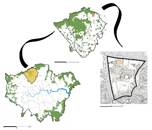
Figure 2: Location of the site.
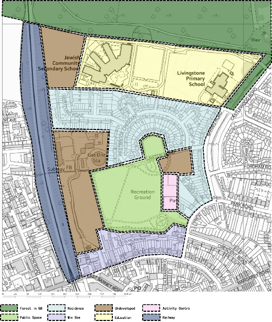
Figure 3: Functional zoning of the site.
The New Barnet Residential Area is located in the northeastern corner of the Barnet administrative district, north of the capital city of London. It is approximately 16.2 km away from the city center and covers an area of about 35.4 hectares (Figure 2). The residential area was developed after World War II and primarily served as housing for veterans and their families. The road network within the residential area follows a cul-de-sac layout, and the housing typology consists of semi-detached houses, representing a typical London suburban residential area. The residential area is divided into six functional zones: residential zone, commercial zone, campus zone, public green space and activity zone, green belt protection forest zone, and railway commuting zone. As shown in Figure 3, the public green space is located at the center of the site, surrounded by the residential zone. Two schools are situated to the north of the residential area, and the green belt protection forest zone is located at the northernmost part of the site. The commercial zone is positioned at the southernmost part of the site, while the railway runs along the western side.
The New Barnet Residential Area falls under the jurisdiction of the Barnet district, and its regional planning policy is based on the principles of sustainable development. The policy emphasizes the harmonious coexistence of the residential area with the natural environment, including the protection of adjacent green belts and the control of architectural facades to maintain a natural style. The policy also emphasizes energy efficiency and environmental sustainability in building design, imposes strict regulations on alterations to existing buildings, and emphasizes community development. The vision for the residential area aims to create a self-sufficient, idyllic lifestyle for its residents [16]. Therefore, studying the New Barnet Residential Area is significant in understanding the relationship between urban green belts and suburban residential areas and exploring new approaches and methods for integrating and sustaining the coexistence of suburban residential areas and green belts.
2.2. Analysis of Existing Issues in the New Barnet Site
Through on-site investigations, the following issues were identified on the site:
2.2.1. Limitations of the Residential Area Road Network
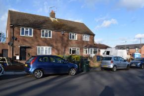
Figure 4-1.
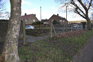
Figure 4-2.
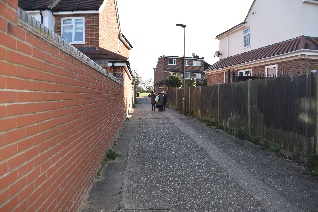
Figure 4-3.
Figure 4-1 to 4-3: Limitation of road network
Firstly, the sidewalks on both sides of the residential area roads are extensively occupied. As shown in Figure 4-1, vehicles and garbage bins significantly encroach upon the pedestrians’ space. Secondly, the planning of pedestrian routes within the residential area lacks human-centric design. As depicted in Figure 4-2, due to insufficient consideration of residents’ convenience in road design, residents frequently create informal pathways by trampling on lawns. Thirdly, there are limitations in the connectivity between residential units. Figure 4-3 illustrates that the rear walls of semi-detached houses in the residential area create narrow or closed pathways on the sides and back of the building clusters, resulting in low efficiency, compromised aesthetics, and reduced safety.
2.2.2. Low Utilization Rate of Public Green Spaces in the Residential Area
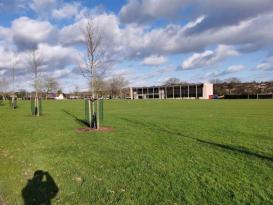
Figure 5-1.
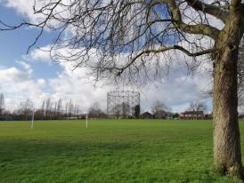
Figure 5-2.
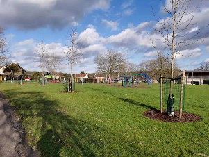
Figure 5-3.
Figure 5-1 to 5-3: Low utilization rate of green space
The central public green space is the only public area within the residential area, as shown in Figure 5. It consists of a large lawn area with a small children's play area to the north and an indoor sports facility to the east. However, on-site investigations reveal that only a few residents walk their dogs in the green space, no one engages in sports activities or leisure, and only a small number of nearby students utilize the children's play area while waiting for the bus after school, without prolonged stays.
2.2.3. Low Social Interaction among Residents in the Residential Area
Residents in the residential area engage in three primary types of activities within the community: walking their dogs alone, driving for transportation, and carrying out activities in their front yards, such as gardening, plant trimming, or car washing. However, there is a lack of visible social interaction among households within the residential area.
Based on the above analysis, the fences in the rear yards of single-story semi-detached houses in the New Barnet residential area obstruct potential road networks and hinder residents’ ease of movement. Moreover, the spatial layout of the residential area results in a significant separation between existing public spaces and the residential zone, leading to low utilization efficiency. Additionally, the rear yards create physical barriers that limit spatial connectivity among residents, thus diminishing the possibility of social interactions. Therefore, this study aims to focus on the renovation of the rear yards of single-story semi-detached houses in the New Barnet residential area.
2.3. Generation of the “Green Courtyard Residence” Concept
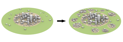
Figure 6-1.
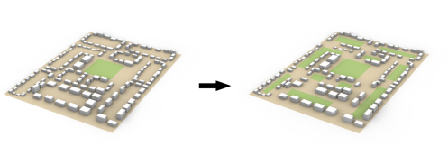
Figure 6-2.
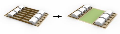
Figure 6-3.
Figure 6-1 to 6-3: Conceptual illustration of the “Green Courtyard Residence”
Based on reflections on the relationship between urban green spaces and residential areas in London, as well as an analysis of the existing site issues, this study proposes the concept of the “Green Courtyard Residence.” This concept focuses on five issues across three spatial scales (Figure 6):
At the urban scale, it emphasizes the spatial relationship between green belts and the city. As shown in Figure 6-1, the concept of the Green Courtyard Residence advocates for an organic integration and mutual permeation of green belts and urban living environments at this spatial scale. For cities, the mutual permeation of the city and green belts limits the possibility of high-density expansion beyond the carrying capacity of the environment, while also breaking the limitations imposed by green belts on urban development. Similarly, for green belts, the development model of mutual permeation with the city brings urban populations into green belts, enhancing the economic and social benefits of various green spaces within green belts while maintaining their original ecological benefits.
At the site scale, building upon the organic integration and mutual permeation of green belts and urban living environments at the urban scale, the focus shifts to two key issues. Firstly, it addresses the integration of public green spaces and residential areas in the New Barnet residential area. According to the analysis in section 2.2, the main obstacle to integration is the rear yards of residential buildings. Therefore, at this scale, the construction of green courtyards becomes the key, replacing the rear yards of single-story semi-detached houses with public green spaces. As shown in Figure 6-2, by reevaluating the existing building clusters on the site, they are integrated into multiple courtyard-style residential clusters centered around small public green spaces, thereby achieving the integration of public green spaces and residential areas. Secondly, it addresses the overall connectivity of the site’s road network. The addition of public green spaces breaks the previously enclosed spatial pattern of residential building clusters, transforming inaccessible or difficult-to-access rear yards into public spaces, thereby enhancing pedestrian accessibility within the residential area. However, to overcome the limitations of the entire residential area's road network, it is necessary to go beyond treating each courtyard as an individual unit and further establish connectivity between the spaces of each courtyard. Therefore, based on the reintegration of courtyard-style residential clusters, the concept of the “Green Courtyard Residence” establishes interconnections between the public green spaces of each courtyard and separates them from the motor vehicle road network, enabling the overall connectivity of the residential area's road network and enhancing residents' freedom and safety in pedestrian movement.
At the courtyard scale, this study applies the concept of the “Green Courtyard Residence” to further deepen the consideration of the integration between public green spaces and residential areas, with a particular focus on the spatial relationship between courtyard public green spaces and residential buildings within courtyard-style residential clusters. As shown in Figure 6-3, the introduction of public green spaces as courtyards within the building clusters replaces the rear yards of single-story semi-detached houses without spatial conflicts with the front yards of the buildings. Therefore, in handling the spatial relationship between the added public green spaces and residential buildings, the front yards of the residential buildings can be preserved, providing residents with private outdoor spaces while also offering more convenient and accessible social and recreational public spaces.
2.4. Analysis of the “Green Courtyard Residence” Results
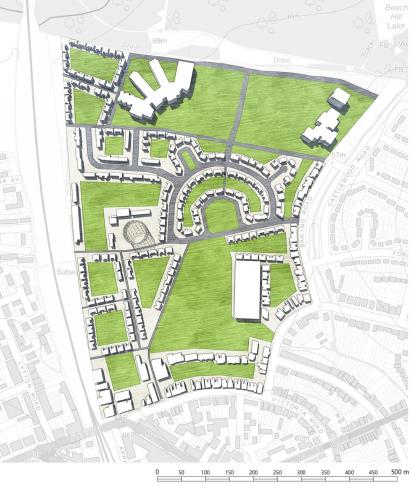
Figure 7-1.
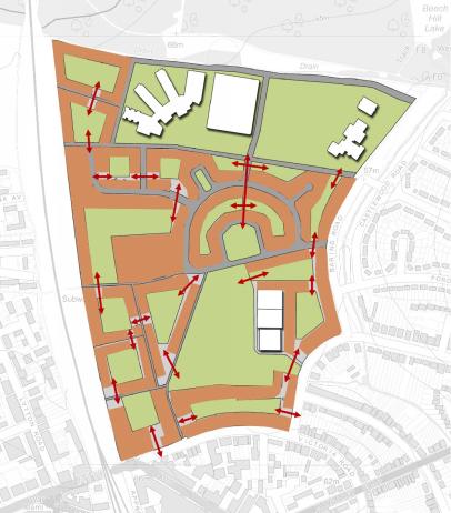
Figure 7-2.
Figure 7-1 to 7-2: Master plan and accessibility analysis of New Barnet after renewal
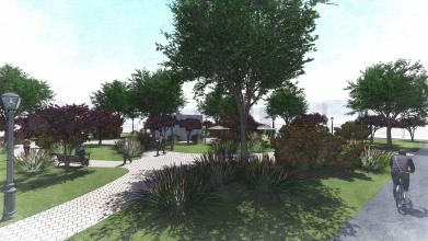
Figure 8-1.
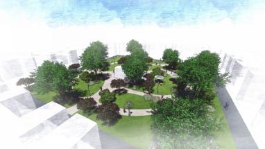
Figure 8-2.
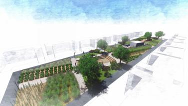
Figure 8-3.

Figure 8-4.
Figure 8-1 to 8-4: Renderings of the public green spaces in the “Green Courtyard”
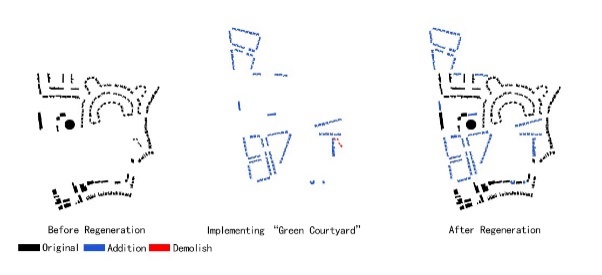
Figure 9-1.
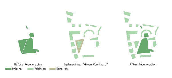
Figure 9-2.
Figure 9-1 to 9-2: Comparison of the spatial pattern between the residential area and public green space before and after the renewal
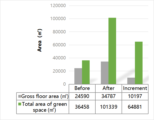
Figure 10: Comparison of the gross area between the residential area and public green space before and after the renewal.
Guided by the concept of the “Green Courtyard Residence,” the spatial pattern of the New Barnet residential area has been transformed into multiple courtyard-style building clusters centered around public green spaces (Figure 7-1). Firstly, these courtyards are interconnected spatially, providing residents with safe and aesthetically pleasing spaces for movement and leisure, to some extent addressing the limitations of the original site's road network (Figure 7-2). Secondly, compared to the original central public green space in the New Barnet residential area, the newly added courtyard public green spaces have improved landscape quality and functionality. These public green spaces can be divided into gardens and farms (Figure 8). As shown in Figure 8-1 to 8-2, the gardens are designed in a natural style, with the planting of flowers, shrubs, and herbaceous plants, providing residents with spaces for floral cultivation. As shown in Figure 8-3 to 8-4, the farms are designed in a geometric style, with various agricultural crops planted, providing residents with spaces for agricultural cultivation. The gardens and farms not only realize the idyllic lifestyle desired by British residents and fulfill the vision of creating a self-sufficient idyllic life for residents in the residential area policy, but more importantly, the integration of public green spaces and housing on a spatial level brings residents closer to nature and to each other. While residents no longer have private rear yards, they collectively own the “Green Courtyard,” which has a larger area and requires the joint efforts of the courtyard unit residents for maintenance. The process of managing and maintaining the green courtyards has, to some extent, facilitated social interactions among residents. At the same time, the “Green Courtyard” provides potential venues for various activities such as floral and agricultural competitions, contributing to the vitality and shaping of the community.
By introducing the “Green Courtyard” concept for renewal, the process is shown in Figure 9. Analyzing the data related to residential housing and public green spaces in the residential area, the results are shown in Table 1: the original total building area of the site was 24,590 square meters with a building density of 6.95%; the total area of public green spaces was 36,458 square meters with a public green space density of 10.31%; the green building ratio was 1.483. After the renewal, the total building area increased to 34,787 square meters, with an additional construction area of 10,197 square meters and a renovation area of 144 square meters, resulting in a building density of 9.8%. The total area of public green spaces after the renewal increased to 101,339 square meters, with an additional green area of 64,881 square meters, and a public green space density of 28.68%. The green building ratio after the renewal was 2.913.
Through a comprehensive comparison of the data related to residential housing and public green spaces before and after the introduction of the “Green Courtyard Residence,” it can be observed that after the renewal, the total residential building area in the residential area increased by 41.5%, and the building density increased by 3.36%. The total area of public green spaces increased by 178.0%, and the public green space density increased by 18.37%. The green building ratio increased by 96.4%. The significant increase in the green building ratio, combined with the diverse functions, beautiful landscapes, and convenient access of the public green spaces in the “Green Courtyard,” not only indicates an increase in the per capita green space area for residents at the data statistical level but also ensures that these newly added green spaces can be practically utilized by the residents of the residential area.
The feasibility of the “Green Courtyard Residence” construction is mainly analyzed from three aspects. First is the consideration of building form. The British single-story semi-detached houses have entrances and exits at the front and back of the ground floor, so transforming the rear yard into a public green space will not inconvenience residents’ access to the buildings, and no structural adjustments are needed for the houses. Second is the consideration of residents’ land ownership. The introduction of the “Green Courtyard Residence” concept does not conflict with residents’ private land ownership. While the rear yards are transformed into public green spaces, the front yards of each household before the renovation remain private. This ensures that residents still have outdoor spaces (the original front yards) for privacy while increasing outdoor public spaces (the original rear yards). Third is the consideration of real estate value. Although introducing the “Green Courtyard Residence” may reduce the private area per housing unit, the significant addition of public spaces can be considered as shared areas for each household. Moreover, the added public green spaces bring various additional values to the residential area, becoming a selling point for real estate developers to increase the unit price per area. Therefore, it can be inferred that the introduction of the “Green Courtyard” will increase the real estate value of the New Barnet residential area, aligning with market logic. Thus, the “Green Courtyard Residence” has high feasibility in terms of both technical and economic aspects.
3. Conclusion and Prospects
In summary, the “Green Courtyard Residence” model is formed based on comprehensive considerations of London’s urban green belt policy and the current shortage of urban housing supply. By integrating residential areas with public green spaces, the model treats public green spaces and residential spaces as a unified spatial unit and carries out spatial reconstruction of the residential area accordingly. This spatial model not only prevents New Barnet from falling into the dilemma of sacrificing residential space for the natural environment during the renewal process but also simultaneously increases the residential density and green space density of the area after the renewal. Therefore, it can be said that the introduction of the “Green Courtyard Residence” model alleviates the antagonistic relationship between the protective function of the urban green belt and urban development in London. The green belt no longer becomes a shackle on urban development. Furthermore, due to the close integration of green spaces and the urban fabric, it prevents the city from exceeding its environmental carrying capacity. It transforms the control of the urban green belt into a controllable and manageable development.
Looking ahead to the future development of London’s urban green belt, after applying the “Green Courtyard Residence” spatial model to the construction of residential areas within the green belt, based on the data analyzed and summarized in section 2.4, it can be anticipated that the model will balance the increment of urban housing supply and the maintenance or even increment of urban green spaces. The mutual antagonism between the living environment and the natural environment caused by the highly restrictive policies of London’s urban green belt is thus mitigated. Ecologically, due to the close combination of residential buildings and public green spaces in the “Green Courtyard Residence,” the distances between green spaces are relatively close, thereby avoiding the fragmentation of natural activities (such as planting and migration of flora and fauna) within green spaces. Additionally, by establishing detailed regulations for the protection of public green spaces in future residential areas within the urban green belt, the ecological environment of the green belt can be protected at the human level. Regarding the preservation of historical towns, if the expansion of residential areas using the “Green Courtyard Residence” model is to take place near existing historical towns within the urban green belt, it is only necessary to unify the architectural facades of new residential buildings and the landscapes within each “courtyard” with the historical town’s period style. As for the protection of existing agricultural land within the urban green belt, new residential areas can reserve space for agricultural land, and the “Green Courtyard” concept can encourage residents to participate in the cultivation of crops in the courtyard public green spaces adjacent to the existing farmland. This approach not only shapes the unique characteristics and vitality of residential areas but also realizes the vision of an ecologically sustainable self-sufficient rural lifestyle. Therefore, it can be said that the “Green Courtyard Residence” model is a feasible solution to reconcile the antagonism between suburban residential space and green space within the existing London urban green belt policies.
Although the “Green Courtyard Residence” model specifically addresses the issues of residential areas in London, the fundamental methods employed can provide inspiration for the relationship between Chinese cities and green spaces. While China’s cities are currently transitioning from extensive development to intensive development, the continuous growth of the urban population and increasing population density will create a demand for urban development in the future. Therefore, facing urban development should not be about forcibly blocking it and setting urban and natural environments in opposition but rather about integration and guidance, allowing cities and green spaces to develop harmoniously and become vast “Green Courtyard Residences.”
Note: Figure 1 is taken from reference [5]; Figures 2 is created by the authors based on references [2], [16], and maps generated by Digimap; Figure 3 is created by the authors based on the Digimap map base; Figures 4-5 are self-captured by the authors; Figure 6 is created by the authors; Figure 7 is created by the authors based on the Digimap base map; Figures 8-9 are created by the authors; The data in Table 1 is collected and organized by the authors.
References
[1]. Xie, X., Kang, H., Behnisch, M., Baildon, M. and Krüger, T. (2020). To What Extent Can the Green Belts Prevent Urban Sprawl? — A Comparative Study of Frankfurt am Main, London and Seoul. Sustainability, 12(2), p.679.
[2]. London First, Quod and SERC. (2015). The Green Belt: A Place for Londoners? Available online at: https://www.quod.com/wp-content/uploads/2015/05/Green-Belt-Report_High-res.pdf
[3]. Amati, M. (2008). Urban Green Belts in the Twenty-First Century. Ashgate Publishing Company Press: Hampshire, UK.
[4]. Thomas, D. (1963). London's Green Belt: The Evolution of an Idea. The Geographical Journal, 129(1), p.14.
[5]. Mace, A. (2018). The Metropolitan Green Belt, changing an institution. Progress in Planning, 121, pp.1-28.
[6]. Cheshire, P. (2009). Urban containment, housing affordability and price stability— Irreconcilable goals. SERC and LSE, 1–16.
[7]. Londongreenbeltcouncil.org.uk. (2021). London Green Belt Council – Protecting London's Green Belt. [online] Available at: <https://londongreenbeltcouncil.org.uk/>.
[8]. Papworth, T. (2015). The Green Noose: An analysis of Green Belts and proposals for reform. Adam Smith Institute. Available from: http://www.adamsmith.org/wp-content/uploads/2015/04/The-Green-Noose1.pdf
[9]. Cheshire, P. (2014). Where should be build on the Greenbelt? LSE blog: British Politics and Policy. Available from: http://blogs.lse.ac.uk/politicsandpolicy/building-on-greenbelt-land/
[10]. Royal Town Planning Institute (RTPI). (2015). Building in the Green Belt? A Report into Commuting Patterns in the Metropolitan Green Belt. Available at: http://www.rtpi.org.uk/media/1432483/Building_in_the_green_belt.pdf
[11]. FREESTONE, R. (1992). SYDNEY'S GREEN BELT 1945–1960. Australian Planner, 30(2), pp.70-77.
[12]. MacKaye, B. (1928). The New Exploration: A Philosophy of Regional Planning; University of Illinois Press: Chicago, IL, USA.
[13]. Hall, P. (1963). London 2000; Faber & Faber: London, UK.
[14]. Town and Country Planning Association (TCPA). (2002). Green Belt-TCPA Policy Statement; TCPA: London, UK.
[15]. Elson, M.J. (1986). Green Belts: Conflict Mediation in the Urban Fringe; Heinemann: London, UK.
[16]. Barnet.gov.uk. (2021). [online] Available at: <https://www.barnet.gov.uk/sites/default/files/assets/citizenportal/documents/planningconservationandbuildingcontrol/PlanningPolicy/LocalPlan/DPD/LocalPlanCoreStrategyDPDSeptember2012.pdf>.
Cite this article
Zheng,Z.;Wang,X. (2023). “Green Courtyard Residential Areas”: Exploring the Spatial Pattern of London Suburban Residential Areas Integrating Public Green Spaces and Living Spaces. Advances in Economics, Management and Political Sciences,35,63-78.
Data availability
The datasets used and/or analyzed during the current study will be available from the authors upon reasonable request.
Disclaimer/Publisher's Note
The statements, opinions and data contained in all publications are solely those of the individual author(s) and contributor(s) and not of EWA Publishing and/or the editor(s). EWA Publishing and/or the editor(s) disclaim responsibility for any injury to people or property resulting from any ideas, methods, instructions or products referred to in the content.
About volume
Volume title: Proceedings of the 7th International Conference on Economic Management and Green Development
© 2024 by the author(s). Licensee EWA Publishing, Oxford, UK. This article is an open access article distributed under the terms and
conditions of the Creative Commons Attribution (CC BY) license. Authors who
publish this series agree to the following terms:
1. Authors retain copyright and grant the series right of first publication with the work simultaneously licensed under a Creative Commons
Attribution License that allows others to share the work with an acknowledgment of the work's authorship and initial publication in this
series.
2. Authors are able to enter into separate, additional contractual arrangements for the non-exclusive distribution of the series's published
version of the work (e.g., post it to an institutional repository or publish it in a book), with an acknowledgment of its initial
publication in this series.
3. Authors are permitted and encouraged to post their work online (e.g., in institutional repositories or on their website) prior to and
during the submission process, as it can lead to productive exchanges, as well as earlier and greater citation of published work (See
Open access policy for details).
References
[1]. Xie, X., Kang, H., Behnisch, M., Baildon, M. and Krüger, T. (2020). To What Extent Can the Green Belts Prevent Urban Sprawl? — A Comparative Study of Frankfurt am Main, London and Seoul. Sustainability, 12(2), p.679.
[2]. London First, Quod and SERC. (2015). The Green Belt: A Place for Londoners? Available online at: https://www.quod.com/wp-content/uploads/2015/05/Green-Belt-Report_High-res.pdf
[3]. Amati, M. (2008). Urban Green Belts in the Twenty-First Century. Ashgate Publishing Company Press: Hampshire, UK.
[4]. Thomas, D. (1963). London's Green Belt: The Evolution of an Idea. The Geographical Journal, 129(1), p.14.
[5]. Mace, A. (2018). The Metropolitan Green Belt, changing an institution. Progress in Planning, 121, pp.1-28.
[6]. Cheshire, P. (2009). Urban containment, housing affordability and price stability— Irreconcilable goals. SERC and LSE, 1–16.
[7]. Londongreenbeltcouncil.org.uk. (2021). London Green Belt Council – Protecting London's Green Belt. [online] Available at: <https://londongreenbeltcouncil.org.uk/>.
[8]. Papworth, T. (2015). The Green Noose: An analysis of Green Belts and proposals for reform. Adam Smith Institute. Available from: http://www.adamsmith.org/wp-content/uploads/2015/04/The-Green-Noose1.pdf
[9]. Cheshire, P. (2014). Where should be build on the Greenbelt? LSE blog: British Politics and Policy. Available from: http://blogs.lse.ac.uk/politicsandpolicy/building-on-greenbelt-land/
[10]. Royal Town Planning Institute (RTPI). (2015). Building in the Green Belt? A Report into Commuting Patterns in the Metropolitan Green Belt. Available at: http://www.rtpi.org.uk/media/1432483/Building_in_the_green_belt.pdf
[11]. FREESTONE, R. (1992). SYDNEY'S GREEN BELT 1945–1960. Australian Planner, 30(2), pp.70-77.
[12]. MacKaye, B. (1928). The New Exploration: A Philosophy of Regional Planning; University of Illinois Press: Chicago, IL, USA.
[13]. Hall, P. (1963). London 2000; Faber & Faber: London, UK.
[14]. Town and Country Planning Association (TCPA). (2002). Green Belt-TCPA Policy Statement; TCPA: London, UK.
[15]. Elson, M.J. (1986). Green Belts: Conflict Mediation in the Urban Fringe; Heinemann: London, UK.
[16]. Barnet.gov.uk. (2021). [online] Available at: <https://www.barnet.gov.uk/sites/default/files/assets/citizenportal/documents/planningconservationandbuildingcontrol/PlanningPolicy/LocalPlan/DPD/LocalPlanCoreStrategyDPDSeptember2012.pdf>.