


1. Introduction
In recent years, the frequent occurrence of flood disasters in our country has caused serious harm to human society and ecological environment. The flood resistance, disaster reduction and defense capabilities of water conservancy projects are particularly important. In 2023, the General Office of the Ministry of Water Resources proposed that the construction of water conservancy projects should give priority to high-quality development, ensure project safety and flood control safety, and help achieve high-quality development of water conservancy.
In 2022, the Ministry of Water Resources proposed that water conservancy projects should take digitalization, networking and intelligence as the main line, take digital scenarios, intelligent simulation and accurate decision-making as the path, and take the construction of digital twin basins as the core, comprehensively promote the construction of computing data, algorithms and computing power, and accelerate the construction of a smart water conservancy system with forecasting, early warning, preview and planning functions.
As the backbone project of the new land-sea passage in western China, the Pinglu Canal project is a landmark project to speed up the construction of a powerful transportation country. The Guangxi Zhuang Autonomous Region government clearly proposed to actively build a "digital twin Pinglu Canal", and held a public tender for the digital twin platform application services during the construction of the Western land-Sea New Passage (Pinglu) canal in January 2024, reflecting the importance of the government and all sectors of society to the safety of water-related projects and the application of digital twins. Pinglu Canal coastal project is often faced with flood risk, digital empowerment to build a digital twin water conservancy early warning system, improve the accuracy and science of water conservancy early warning, and give full play to the economic and social benefits of Pinglu Canal.
The flood early warning system still has drawbacks such as insufficient depth of business application, insufficient business early warning capacity, and weak monitoring system [1]. The digital twin water conservancy early warning system based on physical level and numerical simulation is proposed in this paper, which uses the coupling algorithm of multi-physical field and multi-dimension to predict the change of the actual situation. Each subsystem integrates all kinds of water conservancy information resources, realizes the network, automation, intelligence and visualization of water conservancy information perception, collection, transmission, summary, analysis, early warning and application, improves the efficiency of the application and management of digital twin water conservancy projects, and realizes real-time, scientific monitoring and intelligent management.
The rest of this paper is as follows: the concept of digital twin technology, core key technologies such as diversified coupling algorithm, the design of "1+2+4" digital twin intelligent water conservancy cloud platform, and summary.
2. Digital twin technology
Digital twin is driven by multi-dimensional virtual model and fused data, and realizes monitoring, simulation, prediction, optimization and other practical functional services and application requirements through virtual-real closed-loop interaction. As an important enabling way to realize digital transformation and promote intelligent upgrading, digital twin has been attracting the attention of all walks of life, and has moved from theoretical research to practical application stage[2]. In the field of water conservancy, digital twin technology can digitize the upstream and downstream, left and right banks, main and tributaries of rivers in the target basin or reservoir area, as well as the engineering system, influence scope, economic and social factors of water conservancy construction in related waters, and form two-dimensional images and charts and three-dimensional simulation models to digitally map and display the physical world. It can realize the digitization of wading elements, real-time perception, simulation and visualization[3]. China's first major project for the construction of digital twin basins, the construction of a water monitoring system covering the Yangtze River Basin, has started at the end of April 2023.
The digital twin technology proposed in this paper uses the physical level to build a visual digital water conservancy model, combined with the monitoring data of the natural environment around the water conservancy project transmitted by field sensors, to calculate the current and future hydrological conditions of the river, especially during flood prediction and preview. Establish a digital twin intelligent water cloud platform to realize the effective combination of intelligent water conservancy facilities and physical water conservancy facilities.
3. Core technology and application
3.1. Digital twin architecture
A complete digital twin architecture includes physical layer, data layer, model layer, function layer and capability layer, corresponding to physical object, object data, dynamic model, function module and application capability respectively [4]. The core principle of digital twin water conservancy early warning technology is: to realize the visual presentation of hydraulic engineering buildings at the physical level, that is, to map the whole process of hydraulic engineering work and the force analysis equation of unit structure into the virtual model of digital twin, to realize the whole process monitoring and digital decision analysis; Each digital twin system integrates water conservancy information resources to realize the network, automation, intelligence and visualization of water conservancy information perception, collection, transmission, summary, analysis, early warning and application.
Here are the key technologies.

Figure 1. Digital twin architecture and core elements
3.2. Diversified coupling algorithms
The multi-physics coupling algorithm and multi-dimension coupling algorithm can accurately calculate the evolution process of natural disasters on the physical level, and make full use of the calculation results to improve the scientific and accuracy of prediction. Among them, the multi-physical field coupling algorithm makes coupling calculation of various factors affecting the dam disaster, which better reflects the nonlinear process of mutual influence of various factors and has different evolution laws, so that the results are more in line with the reality, and provides a strong guarantee for achieving good digital mapping display effect and functional services. The multi-dimensional coupling algorithm combines the one-dimensional hydrodynamic model with the three-dimensional hydrodynamic model, comprehensively considers the advantages and disadvantages of the two models, and effectively solves the computational problems of macroscopic problems. Through the physical correlation of data, the accuracy and fault tolerance are greatly improved, and the monitoring data is combined with correction to make the prediction result more scientific and accurate [5].
3.2.1. Multi-physical field coupling
There are many factors affecting the dam disaster, such as climate, natural vegetation, soil and hydrology, etc. They interact with each other but have different evolution laws, which is a nonlinear process, and it is necessary to carry out multi-physical field coupling calculation of these factors. Such as climate on evaporation; Vegetation coverage ratio to flood peak discharge; Soil stability for safe dam operation; Based on the Navier-Stokes equation, the multi-physics coupling equation is obtained:
\( {f_{x}}-\frac{1}{ρ}\frac{∂p}{∂x}+v{∇^{2}}{u_{x}}=\frac{d{u_{x}}}{dt} \)
\( {f_{y}}-\frac{1}{ρ}\frac{∂p}{∂y}+v{∇^{2}}{u_{y}}=\frac{d{u_{y}}}{dt} \)
\( {f_{z}}-\frac{1}{ρ}\frac{∂p}{∂z}+v{∇^{2}}{u_{z}}=\frac{d{u_{z}}}{dt} \)
fx fy fz is mass force; \( ρ \) is the density; \( {∇^{2}}{u_{x}} {∇^{2}}{u_{y}} {∇^{2}}{u_{z }} \) is Laplace's formula.
3.2.1.1. Finite element preview under multi-physics coupling
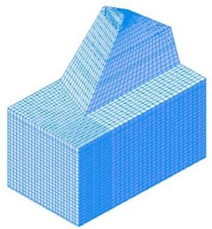
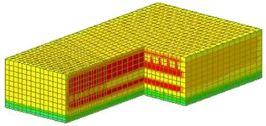
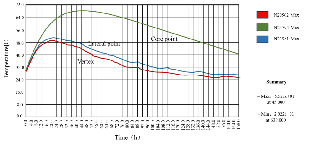
Based on the finite element method, the partial differential equation of the factors affecting the dam disaster is numerically calculated. Finite element not only has high calculation accuracy, but also can adapt to various complex shapes. It has become an effective engineering analysis method and an important calculation method of multi-physical field coupling when there are many factors affecting each other of various physical problems in engineering construction and flood and drought disasters. From January to April 2024, with the assistance of the relevant construction units of Pinglu Canal section, this study conducted a technical pilot of the multi-physical field coupling algorithm based on the finite element method, conducted a dynamic analysis of the main physical fields (taking temperature field as an example) of the large volume concrete structures of Bridges and DAMS, analyzed the early warning state, and evaluated the overall safety performance in real time. This technology pilot will help to continuously optimize and improve the multi-physical field coupling technology, and better apply to the water conservancy early warning function after the completion of water conservancy projects.
|
|
Figure 2. Finite element modeling of foundation base. | Figure 3. Cloud map of temperature field distribution (input 28℃, 24h). |
| |
Figure 4. Temperature time history curve (entering 28℃). | |
3.2.2. Multidimensional coupling
The one-dimensional hydrodynamic model is mainly used in a single hydraulic project. It can deal with constant flow and unsteady flow, and provides boundary conditions such as water level, flow, water-flow relationship, etc. It can consider interval inflow or point source discharge, and can output the model calculation results of water level and flow of monitoring section in real time. The calculation of one-dimensional river network flow mathematical model adopts the "hierarchical solution method" [6]. The basic principle is as follows: Firstly, the Saint-Venant equations on each micro-section between two adjacent sections in the river reach are discreted into linear equations of water level and discharge in the section; Through the linear relationship between the water level and the discharge of the adjacent section and the self-elimination of the linear equations, the reach equation with the water level and discharge as the state variables is formed. By using the compatibility equation of bifurcation point and boundary equation, a certain state variable of the first and last sections of the river reach is eliminated to form a nodal equation set of nodal water level (or flow) [7]. Finally, the simplified equations are solved by chasing method. The one-dimensional hydrodynamic module is built on the basis of the Saint-Venant equations:
\( \frac{∂Q}{∂x}+\frac{∂A}{∂t}=q \)
\( \frac{∂Q}{∂t}+\frac{∂(\frac{{Q^{2}}}{A})}{∂x}+gA\frac{∂h}{∂x}+\frac{gQ|Q|}{{C^{2}}AR}=0 \)
Q is the flow; q is lateral inflow; A is the area of water crossing section; h is the water level; R is the hydraulic radius; C is Xie CAI coefficient; α is the momentum correction factor.
Shanliang Zhang used FLOW-3D hydrodynamic model software[8] and VOF(free fluid surface tracking algorithm) method to track liquid-liquid or liquid-solid interface [9]. Based on Cartesian coordinate system, he built a numerical solution to the complete NS equation, which can be used in the fields of hydraulic engineering, hydraulic construction and water environment. Embodies the essence of multi-dimensional coupling. Its main governing equations include continuity equation and momentum equation. The turbulence model adopts RNGk-ε model[10], and the free water surface is determined by fluid volume function[11].
Continuity equation:
\( \frac{∂}{∂{x_{i}}}({u_{i}}{A_{i}})={R_{DIF}}+{R_{SOR}} \)
Momentum equation:
\( \frac{∂{u_{i}}}{∂t}+\frac{1}{{V_{F}}}({u_{j}}{A_{j}}\frac{∂{u_{j}}}{∂{x_{j}}})=-\frac{1}{ρ}\frac{∂p}{∂{x_{i}}}+{G_{i}}+{f_{i}} \)
ui is the velocity component, Ai is the flowable area fraction component, RDIF is the turbulent dissipation term, RSOR is the mass source term, VF is the fluid volume fraction, ρ is the fluid density, p is the pressure, Gi is the gravitational acceleration component, and fi is the viscous acceleration component.
The advantage of one-dimensional hydrodynamic model is high computational efficiency, but the disadvantage is that it is helpless for terrain without significant channel shape. The 3D model can accurately simulate the flow pattern of water flowing through complex structures, but the computational efficiency is relatively low. Based on the advantages and disadvantages, the two types of models are horizontally coupled. Three-dimensional hydrodynamic model is used for large-scale hydraulic projects or complex water conservancy areas, and one-dimensional hydrodynamic simulation is used for fine simulation and non-key areas with significant channel characteristics. On the premise of meeting the needs of engineering calculation, the information integration efficiency of each digital twin system in physical level is improved.
3.2.2.1. Model check under multi-dimensional coupling
In order to verify the validity of the data obtained by the coupling model, the research group conducted on-site measurements of the sectional flow and velocity in some reaches of Pinglu Canal from March to May 2024. The verification results show that the flow simulation error is basically less than 10%, and the flow velocity simulation error is basically less than 15%, which indicates that our coupling model can reflect the flow and velocity changes more accurately, and can meet the needs of practical simulation and deduction applications.
Figure 5. Verification diagram of cross section flow of Yangwu and Luwu hydrological stations in 2024.
Figure 6. Flow velocity verification diagram of Huangwutun and Xiaojiang hydrographic stations in 2024.
3.2.3. Distributed cell coupling
Due to the needs of modeling and calculation, in the model, we adopt a distributed calculation method, through the calculation results of each distributed unit, combined with monitoring data, in the application of initial conditions and boundary conditions, the use of flexible algorithms, so that each computing unit can be well integrated together and form a macro calculation result. The efficiency and precision of digital twin data processing and the accuracy of dynamic model are improved.
Figure 7. Distributed cell coupling structure diagram
4. Digital twin platform design
Digital twin cloud platform is a new type of digital technology, it combines the physical world with the digital world, using the Internet of Things, big data, artificial intelligence and other technical means to achieve digital modeling, simulation, optimization and prediction of physical systems, thus playing an important role in improving efficiency, reducing costs, optimizing design, etc., can be applied in different scenarios and industries.
Water conservancy is a large-scale and large-scale work, it is difficult to test different schemes in physical river basins, so it can only be rehearsed repeatedly in digital space, and the best scheme can be selected after comprehensive evaluation and analysis, and then applied to practical work. As a comprehensive project management information system, the smart water conservancy project management information platform based on digital twin technology fully considers the management characteristics of Chinese water conservancy project construction management, combines the concept of international project management with the construction management practice of domestic oversized projects, and adopts digital twin technology, cloud technology and other means to release data value. It solves the needs of hierarchical business management and integrated management, provides comprehensive information solutions for the business management process at all stages of water conservancy projects, improves the ability of water conservancy information resource sharing, data service, analysis and calculation, decision support, intelligent application and visual expression, and promotes the modernization of water governance system and governance capacity [12].
The "1+2+4" digital twin intelligent water conservancy cloud platform constructed this time is a smart water conservancy cloud platform built based on digital twin technology, which can give full play to the advantages of high efficiency, cost reduction and optimized design of the digital twin cloud platform. "1+2+4", "1" is the digital twin simulation dam center, "2" is the information management platform and the command and dispatch platform two platforms, "4" is the environmental factor algorithm system, fluid dynamics simulation system, data acquisition system, network transmission system four systems.
As mentioned above, the multi-physical field coupling algorithm is integrated into the environmental factor algorithm system of the digital twin intelligent water conservancy cloud platform; The multi-dimensional coupling algorithm corresponds to the fluid mechanics simulation system in the platform. The "1+2+4" digital twin intelligent water cloud platform not only reflects the essence of distributed coupled deployment and ESB summary technology combination in the structure, but also makes full use of the emerging information technology of multi-physical field coupling and multi-dimensional coupling, and truly integrates the key technologies of the digital twin system into the platform construction. In addition to this, sensors are embedded and equipped into natural and social water recycling systems and form a "sensing Internet of Things" through universal connectivity; Then the "water iot" is integrated through cloud computing to complete the seamless integration of smart water facilities and physical water facilities.
 Figure 8. Digital twin smart water cloud platform "1+2+4" module
5. Conclusion
This paper proposes a digital twin intelligent water conservancy system for disaster warning based on physical level and numerical simulation, introduces the main structure and specific technology of the system, and integrates all kinds of real influencing factors into the digital twin model to maximize the restoration of the real whole process of simulated water conservancy engineering operations in complex geographical environment. Through sensor data collection and coupled calculation of environmental factors, the digital twin cloud platform has the ability of implementation management and independent prediction and preview analysis of future disasters, which is predictive. Therefore, it can provide strong support and compliance for the managers of the flat canal to accurately grasp the flood situation, cope with the flood risk and make scientific decisions, and help the digital and technological development of the flat canal.
References
[1]. Zhai N, Ren J, Wang L P and Dang X X 2022 Exploration and practice of intelligent flood warning analysis platform C.12th Flood Control and Drought Information Forum pp 386-393
[2]. Tao F, Zhang He, QI Q L and Xu J, Sun Z, et al 2019 Digital Twin Model Construction Theory and Application J. Computer Integrated Manufacturing Systems vol 27(01) pp 1-15(in Chinese)
[3]. Cai Y 2022 Construction of intelligent water conservancy system with "four pre-construction" function based on the construction of digital twin watershed J. China Water Resources pp 2-6+p 60
[4]. Tao F, Liu W R, Liu J H and Liu X J, et al 2018 Digital Twin and Its Application J. Computer Integrated Manufacturing Systems vol 24(01) pp 1-18
[5]. Zhou E C 2023 Flood risk analysis and assessment based on hydrodynamic model D North China University of Water Resources and Electric Power
[6]. Zhao J J 2021 Flood control analysis and evaluation of Shanghengli Bridge Project in Nansha New District J. Science and Technology Innovation and Application vol 11(35) pp 43-47 (in Chinese)
[7]. Hu S Y, Shi Y and Wang Y T, et al 2002 Numerical simulation of river-lake flood evolution in the middle and lower reaches of the Yangtze River J. Advances in Water Science vol (03) pp 278-286
[8]. Flow Science, Inc., SantaFe, NM, USA. The FLOW - 3 dversion10. 1 usersmanual (2012)
[9]. Jiang W W, Yu J S, and Wang X Y, et al 2019 Water flow simulation and calculation of bridge based on 3D hydrodynamic model and empirical formula J. Water Resources and Hydropower Technology vol 51(9) pp 97-104(in Chinese)
[10]. He Y, Jin S. 2019 Research on three-dimensional numerical Simulation of curved estuary J. Journal of Water Resources and Architectural Engineering vol 17(2) pp 232-238+p 244
[11]. Zhang S L 2023 Simulation and analysis of key parameters of water resistance of mountain stream bridge J. Water Resources Research vol 12(1) pp 65-76
[12]. Xia R L, LI T, LI K and Zhang Y P 2022 Research and application practice of multi-model cloud service platform construction J. China Flood Control and Drought Relief vol 32(03) pp 52-56+p 60
Cite this article
Lan,L.;Chen,L.;Chen,X.;Liao,B.;Chen,R. (2024). Digital twin water conservancy early warning system based on physical level and numerical simulation in intelligent water conservancy construction. Theoretical and Natural Science,53,51-58.
Data availability
The datasets used and/or analyzed during the current study will be available from the authors upon reasonable request.
Disclaimer/Publisher's Note
The statements, opinions and data contained in all publications are solely those of the individual author(s) and contributor(s) and not of EWA Publishing and/or the editor(s). EWA Publishing and/or the editor(s) disclaim responsibility for any injury to people or property resulting from any ideas, methods, instructions or products referred to in the content.
About volume
Volume title: Proceedings of the 2nd International Conference on Applied Physics and Mathematical Modeling
© 2024 by the author(s). Licensee EWA Publishing, Oxford, UK. This article is an open access article distributed under the terms and
conditions of the Creative Commons Attribution (CC BY) license. Authors who
publish this series agree to the following terms:
1. Authors retain copyright and grant the series right of first publication with the work simultaneously licensed under a Creative Commons
Attribution License that allows others to share the work with an acknowledgment of the work's authorship and initial publication in this
series.
2. Authors are able to enter into separate, additional contractual arrangements for the non-exclusive distribution of the series's published
version of the work (e.g., post it to an institutional repository or publish it in a book), with an acknowledgment of its initial
publication in this series.
3. Authors are permitted and encouraged to post their work online (e.g., in institutional repositories or on their website) prior to and
during the submission process, as it can lead to productive exchanges, as well as earlier and greater citation of published work (See
Open access policy for details).
References
[1]. Zhai N, Ren J, Wang L P and Dang X X 2022 Exploration and practice of intelligent flood warning analysis platform C.12th Flood Control and Drought Information Forum pp 386-393
[2]. Tao F, Zhang He, QI Q L and Xu J, Sun Z, et al 2019 Digital Twin Model Construction Theory and Application J. Computer Integrated Manufacturing Systems vol 27(01) pp 1-15(in Chinese)
[3]. Cai Y 2022 Construction of intelligent water conservancy system with "four pre-construction" function based on the construction of digital twin watershed J. China Water Resources pp 2-6+p 60
[4]. Tao F, Liu W R, Liu J H and Liu X J, et al 2018 Digital Twin and Its Application J. Computer Integrated Manufacturing Systems vol 24(01) pp 1-18
[5]. Zhou E C 2023 Flood risk analysis and assessment based on hydrodynamic model D North China University of Water Resources and Electric Power
[6]. Zhao J J 2021 Flood control analysis and evaluation of Shanghengli Bridge Project in Nansha New District J. Science and Technology Innovation and Application vol 11(35) pp 43-47 (in Chinese)
[7]. Hu S Y, Shi Y and Wang Y T, et al 2002 Numerical simulation of river-lake flood evolution in the middle and lower reaches of the Yangtze River J. Advances in Water Science vol (03) pp 278-286
[8]. Flow Science, Inc., SantaFe, NM, USA. The FLOW - 3 dversion10. 1 usersmanual (2012)
[9]. Jiang W W, Yu J S, and Wang X Y, et al 2019 Water flow simulation and calculation of bridge based on 3D hydrodynamic model and empirical formula J. Water Resources and Hydropower Technology vol 51(9) pp 97-104(in Chinese)
[10]. He Y, Jin S. 2019 Research on three-dimensional numerical Simulation of curved estuary J. Journal of Water Resources and Architectural Engineering vol 17(2) pp 232-238+p 244
[11]. Zhang S L 2023 Simulation and analysis of key parameters of water resistance of mountain stream bridge J. Water Resources Research vol 12(1) pp 65-76
[12]. Xia R L, LI T, LI K and Zhang Y P 2022 Research and application practice of multi-model cloud service platform construction J. China Flood Control and Drought Relief vol 32(03) pp 52-56+p 60