


1.Introduction
Nowadays, technological innovations have played a pivotal role in advancing natural disaster management practices[1,2]. Technologies such as remote sensing and Geographic Information Systems (GIS) have proven invaluable in revealing key information derived from spatial data[3,4,5]. These technologies provide a deep understanding of catastrophic movements, environmental changes[6], urban planning[7], land use[8], socio-economic factors, and emergency relief resources[9]. Effective disaster management strategies are crucial for mitigating loss of life and property[10]. By developing and implementing innovative techniques for damage control, it is possible to reduce casualties, limit economic losses, and enhance disaster preparedness. These techniques include early warning systems[10], efficient evacuation strategies, and resilient infrastructure capable of withstanding the impacts of disasters.
GIS is a powerful technological tool that supports the collection, storage, analysis, and visualization of geospatial data[11,12]. In disaster management, GIS facilitates risk assessment, aids in formulating emergency plans, and informs post-disaster reconstruction[13]. In the domain of disaster prevention and control, remote sensing has become increasingly significant for studying geological disasters[14]. Recent advances in remote sensing sensors have enhanced the collection of high-resolution spatial data, advanced our understanding of Earth’s surface and aiding the monitoring and analysis of natural hazards[15,16]. Technologies such as optical and microwave remote sensing are now integral to contemporary geological disaster research[15]. Optical remote sensing provides high spectral and spatial resolution, offering detailed insights into land-use changes[17]. In tandem with microwave sensing, these technologies supply comprehensive datasets that strengthen the monitoring of disasters. Continued advances in remote sensing will be essential for future developments in disaster management research.
Within urban disaster management, the integration of Building Information Modeling (BIM) and GIS has proven to be a particularly effective means of enhancing disaster response and resilience[18]. Despite its potential, adoption has remained limited, largely due to challenges in system interoperability and data integration. By merging BIM and GIS, authorities can access real-time geospatial data that improves decision-making during emergencies[19]. This synergy streamlines data collection, enhances situational awareness, and ultimately supports more efficient disaster response. In global health emergencies like the COVID-19 pandemic, GIS has similarly demonstrated its capacity to bolster disaster preparedness and response[20,21]. By integrating predictive analysis and AI with GIS, public health authorities can improve decision-making, optimize resource distribution, and refine emergency response strategies[22]. GIS-based systems can track disease spread, optimize evacuation routes, and reinforce emergency medical services, thereby strengthening overall disaster response frameworks. Similarly, effective Evacuation Management Systems (EMS) play an essential role in large-scale emergencies such as wildfires[23]. A GIS-based real-time EMS can improve evacuation routes, identify assembly points, and monitor route status in real time. By integrating stochastic models and GIS tools, such systems can streamline decision-making and ensure swift evacuations. This method has been applied in real-world scenarios, including the Gran Canaria wildfire, where it showed measurable improvements in response times and overall disaster management[23].
While the integration of advanced technologies like GIS, remote sensing, and AI has significantly improved disaster response capabilities, there remain several challenges and opportunities that must be explored. The increasing application of GIS in disaster management has not only highlighted its practical benefits but also underscored the importance of continuous advancements in both technology and methodology. As GIS continues to evolve, a deeper understanding of its applications, strengths, and limitations is necessary to guide future research and development. This review seeks to address these aspects by systematically analyzing recent studies on GIS in disaster response. The following sections detail the methodology used to select, evaluate, and synthesize the literature, providing an in-depth look at the current landscape of GIS applications in disaster management.
2.Material and methods
2.1.Literature Search Strategy
The literature search was conducted using the Web of Science Core Collection. The search strategy focused on two primary topics: GIS and disaster response. To ensure a comprehensive search, the Boolean operator AND was used to combine these topics, allowing for the retrieval of articles that were relevant to both GIS and disaster management. The search was restricted to articles published from 2021 onwards (inclusive), ensuring that only the most recent studies were included in the review. This time frame was selected to capture the latest advancements and trends in the integration of GIS within disaster response, particularly in light of the evolving challenges and technologies post-2020.
2.2.Inclusion and Exclusion Criteria
The initial search yielded 220 articles from the Web of Science Core Collection. After screening for relevance and removing duplicates, 218 articles were retained. Inclusion criteria focused on peer-reviewed journal articles, conference papers, and systematic reviews exploring the application of GIS in disaster response. Only articles published from 2021 onward were considered, ensuring the incorporation of the latest advancements in GIS technology for disaster management. Studies were required to present empirical data, clear methodologies, and practical case studies on the use of GIS in disaster management—covering damage assessment, evacuation planning, and post-disaster recovery. Articles that lacked a clear focus on GIS or disaster response were excluded, as were those that did not undergo peer review. Reviews and meta-analyses without original data, research unrelated to disaster management (e.g., GIS in purely urban planning or environmental studies), and articles in languages other than English were similarly removed. Studies hidden behind paywalls or otherwise inaccessible, such as theses and proprietary reports, were not considered. Following these inclusion and exclusion criteria, the remaining articles were used for data extraction and analysis, forming a comprehensive review of current GIS applications in disaster response.
2.3.Data Extraction and Analysis
For each included study, key information was extracted to form a robust overview of the research landscape. This process began with recording general details—title, authors, publication year, and the journal or conference outlet—and identifying the study’s specific focus on GIS-based interventions in disaster management, such as evacuation planning, damage assessment, or risk management. The methodologies of these studies—ranging from case studies and experimental designs to model simulations and system evaluations—were then summarized. The review also examined the integration of GIS with emerging technologies like BIM, remote sensing, machine learning, and AI to understand how these technologies collectively enhance disaster management processes. Key findings were distilled to underscore GIS’s role in improving disaster preparedness, response, and recovery. Studies were grouped by methodological similarities, highlighting recurrent themes, challenges, and opportunities. This thematic approach revealed both evolving research trends and new technologies in disaster management. The review also critiqued limitations in various GIS applications, such as data quality, software constraints, and integration hurdles. Lastly, the studies’ contributions to future research agendas and technological advances were assessed, providing a roadmap for continued innovation in GIS-based disaster response.
3.Results and Discussion
3.1.Increasing Publications on “GIS in disaster response” and Research Focus
Publications on GIS in disaster response have risen steadily in recent years, underscoring the growing recognition of GIS as an indispensable tool for disaster management. Specifically, the literature expanded from 47 articles in 2021 to 52 in 2022, then to 55 in 2023, and 64 by 2024. This uptick highlights the pivotal role of GIS in improving disaster response capabilities worldwide.
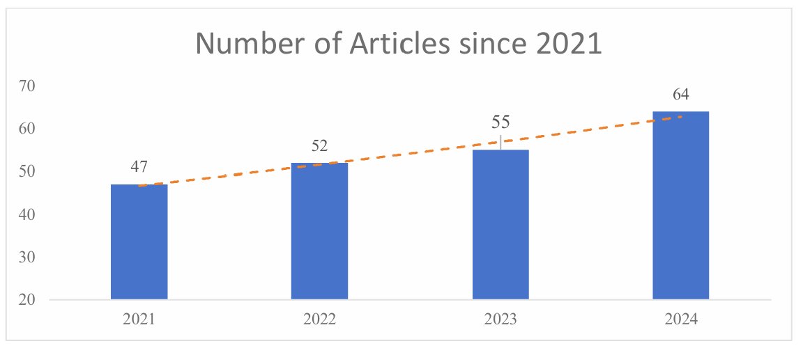
Figure 1: The number of articles on the topic of “GIS in disaster response” published since 2021
Several factors explain the heightened research interest. The frequency and intensity of natural disasters—earthquakes, floods, wildfires, hurricanes—have intensified globally, prompting a pressing need for more efficient, data-driven disaster response frameworks. GIS enables real-time data collection, analysis, and visualization, all of which enhance operational efficiency and decision-making in crisis scenarios. While earlier studies primarily focused on mapping and damage assessment, more recent work has extended into advanced applications, including real-time disaster response, evacuation planning, and post-disaster recovery. A notable trend involves integrating GIS with BIM, remote sensing, and AI to enhance predictive accuracy, optimize evacuation routes, and manage resources effectively. Researchers increasingly recognize GIS not just as a reactive tool for disaster response but also as a core component of proactive risk management strategies—such as modeling hypothetical disaster scenarios, forecasting vulnerability, and shaping early warning systems. Overall, the evolving research indicates a shift toward sophisticated, integrated GIS frameworks that adapt to the growing complexity of modern disaster events.
3.2.Rescue resource allocation and path planning
In disaster response, GIS is indispensable for optimizing resource allocation and path planning through its capabilities in data management, spatial analysis, and decision support[24]. By integrating data on infrastructure, vulnerability, and hazard exposure, GIS identifies areas needing immediate attention, such as hazardous materials storage or fault lines, facilitating effective risk assessments and prioritization of resources[25]. For rescue resource allocation, GIS optimizes the placement of urban emergency shelters by evaluating factors like construction costs, capacity, and accessibility via road networks[26]. This strategic placement ensures that shelters are effectively positioned to serve communities during emergencies. Moreover, GIS models’ disaster scenarios to simulate evacuation routes and determine optimal locations for staging rescue teams, enhancing preparedness and response efficiency[27,28]. Path planning is another critical application where GIS maps damaged roads and infrastructure post-disaster, analyzes traffic flow, and identifies alternative routes for rescue operations. Real-time GIS-based traffic simulations enable dynamic path optimization, allowing rescue efforts to adapt as the situation evolves[29]. Integrating GIS with Building Information Modeling (BIM) and remote sensing further improves response efficiency by providing a precise understanding of damage impacts[30]. Advanced integrations, such as GIS with artificial intelligence (AI), drone-based data collection, and machine learning, continue to enhance rescue efforts' precision and speed[31]. These technologies facilitate more informed decision-making and better coordination among stakeholders, ultimately saving lives and reducing disaster impacts.
3.3.Location of shelters and emergency services
Determining optimal locations for shelters and emergency services is critical for efficient disaster response, and GIS provides essential support in this area. By merging spatial data with demographic, infrastructural, and environmental information, GIS enables planners to minimize disaster impacts and enhance community resilience[32,33]. GIS-based road network accessibility analysis ensures that shelters and emergency facilities are situated in easily reachable areas, facilitating rapid evacuations. For instance, during the Gran Canaria wildfire, dynamic optimization of shelter locations was achieved by integrating traffic flow data, pedestrian routes, and road condition assessments[23]. Additionally, GIS analyzes population density and distribution to ensure equitable access to shelters[34]. The response to Turkey’s 2023 earthquake exemplifies how integrating centralized and decentralized GIS approaches can identify underserved areas and proactively address gaps in emergency coverage[35]. Furthermore, GIS evaluates existing shelters' capacities against projected demands by combining shelter data with real-time population movement and demographic information[36]. Advanced GIS models, such as the minimal facility point model, facilitate the determination of cost-effective shelter network layouts while meeting refuge requirements[37]. Multi-criteria decision-making models within GIS optimize site selection by balancing safety, accessibility, and cost-effectiveness, as demonstrated in urban flood and tsunami evacuation planning[38]. Additionally, GIS enhances network analysis and buffer zone methods to assess the maximum service area of emergency shelters within specific time frames, ensuring that shelters are both accessible and capable of providing timely refuge[39]. In tsunami-prone regions, buffer analysis effectively maps safe zones and evacuation routes, thereby minimizing casualties[40]. By leveraging these GIS applications, emergency planners can design shelter systems that ensure equitable access, maximize resource efficiency, and minimize disaster impacts. The integration of advanced technologies such as remote sensing, machine learning, and real-time monitoring further augments GIS's effectiveness in shelter and emergency service planning, thereby strengthening community resilience against future disasters[41].
3.4.Advanced Technological Integration for Enhanced Decision Support
By combining GIS with artificial intelligence (AI), machine learning, cloud computing, and the Internet of Things (IoT), disaster response systems have become more robust and efficient[42,43]. AI and machine learning algorithms within GIS platforms enable the analysis of large datasets to identify patterns and predict disaster events with greater accuracy[44]. For example, these technologies can forecast the likelihood and impact of earthquakes, floods, and wildfires, facilitating proactive measures such as optimizing evacuation routes and protecting critical infrastructure[45,46]. Cloud computing provides scalable storage and processing power, allowing GIS to handle vast amounts of data generated during disasters[24]. Cloud-based GIS solutions support seamless collaboration among emergency responders, government agencies, and humanitarian organizations by enabling real-time data sharing and updates. This enhances coordination and improves the efficiency of disaster response efforts, especially during large-scale events. These tools create interactive maps that display real-time data overlays, predictive models, and simulation results, aiding in understanding disaster progression and planning effective response strategies. In summary, the integration of GIS with AI, machine learning, cloud computing, and IoT technologies significantly enhances real-time decision support in disaster management. These advanced technological integrations empower GIS to provide comprehensive predictive analytics, facilitate seamless collaboration, and deliver real-time insights, thereby improving preparedness, response, and recovery efforts[47]. As these technologies continue to evolve, their synergistic application with GIS is expected to play an increasingly critical role in building resilient and adaptive communities capable of effectively mitigating the impacts of future disasters.
3.5.Challenges of GIS
Despite these innovations, GIS-based disaster management encounters notable hurdles. Data quality, system interoperability, and limited user training persist as key roadblocks. For example, inconsistent data formats and the lack of standardization across regions complicate the merging of GIS with other disaster-management platforms[48]. Addressing these issues will require internationally recognized data standards and stronger collaborative efforts among stakeholders. Data security and privacy also pose concerns, especially in cross-border disaster responses[44]. Blockchain technology offers a promising avenue for secure, transparent data sharing. By creating an immutable record of data transactions, blockchain could bolster GIS’s reliability in scenarios demanding rapid, large-scale coordination.
4.Conclusion
Geographic Information Systems (GIS) play a vital role in disaster response, contributing significantly to risk assessment, real-time monitoring, resource management, and post-disaster recovery. Recent research affirms GIS’s expanding influence, particularly when integrated with BIM, remote sensing, AI, and machine learning—combinations that substantially enhance both accuracy and speed in disaster response. Despite these gains, challenges related to data quality, interoperability, and user capabilities persist. Greater standardization and improved data-sharing protocols are needed to ensure a seamless integration of GIS with other disaster management platforms. Additionally, more work is required to make GIS-based solutions inclusive for vulnerable populations, especially in developing regions. Looking ahead, GIS is poised to evolve further through improved predictive modeling and proactive disaster mitigation. The real-time integration of cloud-based systems and AI-enhanced decision support holds great promise for refining both short-term and long-term disaster management strategies. As climate change and urbanization intensify global disaster risks, GIS will become increasingly central to building resilience and saving lives. By confronting current limitations and leveraging emerging technologies, GIS will remain at the forefront of a more effective, equitable, and timely global disaster management framework.
References
[1]. Mudassir, G.; Howard, E.E.; Pasquini, L.; etc. Toward Effective Response to Natural Disasters: A Data Science Approach. Ieee Access 2021, 9, 167827-167844, doi:10.1109/ACCESS.2021.3135054.
[2]. Haggag, A.G.; Zaki, S.H.; Selim, A.M. Emergency camps design using analytical hierarchy process to promote the response plan for the natural disasters. Archit Eng Des Manag 2023, 19, 305-322, doi:10.1080/17452007.2022.2125359.
[3]. Tomaszewski, B. Geographic information systems (GIS) for disaster management. Routledge: 2020, ISBN 1351034863.
[4]. Sakib, N.; Hyer, K.; Dobbs, D.; etc. A GIS enhanced data analytics approach for predicting nursing home hurricane evacuation response. Health Inf Sci Syst 2022, 10, doi:10.1007/s13755-022-00190-y.
[5]. Gulluce, Y. A GIS-BASED DECISION ANALYSIS USING MULTI-PARAMETRIC WEIGHTED INDEX MODEL FOR FOREST FIRE RISK MAPPING IN MEDITERRANEAN. Fresen Environ Bull 2022, 31, 8489-8498.
[6]. Zhang, J.; Li, J.; Yang, X.; etc. Rural social-ecological systems vulnerability evolution and spatial-temporal heterogeneity in arid environmental change region: A case study of Minqin Oasis, northwestern China. Appl Geogr 2022, 145, doi:10.1016/j.apgeog.2022.102747.
[7]. Rajput, T.S.; Singhal, A.; Routroy, S.; etc. Urban Policymaking for a Developing City Using a Hybridized Technique Based on SWOT, AHP, and GIS. J Urban Plan Dev 2021, 147, doi:10.1061/(ASCE)UP.1943-5444.0000691.
[8]. Sarkissian, R.D.; Al Sayah, M.J.; Abdallah, C.; etc. Land Use Planning to Reduce Flood Risk: Opportunities, Challenges and Uncertainties in Developing Countries. Sensors-Basel 2022, 22, doi:10.3390/s22186957.
[9]. Park, H.S.; Kwon, S.A.; Azam, M. A study on GIS-based spatial analysis of emergency response for disaster management: Focusing on Seoul. Heliyon 2024, 10, doi:10.1016/j.heliyon.2024.e28669.
[10]. Hermans, T.D.G.; Sakic Trogrlic, R.; van den Homberg, M.J.C.; etc. Exploring the integration of local and scientific knowledge in early warning systems for disaster risk reduction: a review. Nat Hazards 2022, 114, 1125-1152, doi:10.1007/s11069-022-05468-8.
[11]. Jitt-Aer, K.; Wall, G.; Jones, D.; etc. Use of GIS and dasymetric mapping for estimating tsunami-affected population to facilitate humanitarian relief logistics: a case study from Phuket, Thailand. Nat Hazards 2022, 113, 185-211, doi:10.1007/s11069-022-05295-x.
[12]. Awan, H.H.; Kabdrakhmanova, M.; Varol, H.A.; etc. A GIS-Based emergency response and management support framework for Earthquake crisis: A case study of Antakya and Kahramanmaras earthquake in Turkey. Int J Disast Risk Re 2024, 111, doi:10.1016/j.ijdrr.2024.104706.
[13]. Cai, Y.; Chen, C.; Shi, Y.; etc. GIS and hybrid multi-criteria decision analysis based urban flood risk assessment in Hanchuan City, Hubei Province, China. Environ Earth Sci 2024, 83, doi:10.1007/s12665-024-11934-2.
[14]. Kumari, S.; Agarwal, S.; Agrawal, N.K.; etc. A Comprehensive Review of Remote Sensing Technologies for Improved Geological Disaster Management. Geol J 2025, 60, 223-235, doi:10.1002/gj.5072.
[15]. Shastry, A.; Carter, E.; Coltin, B.; etc. Mapping floods from remote sensing data and quantifying the effects of surface obstruction by clouds and vegetation. Remote Sens Environ 2023, 291, doi:10.1016/j.rse.2023.113556.
[16]. Masria, A. Bridging coastal challenges: The role of remote sensing and future research. Reg Stud Mar Sci 2024, 73, doi:10.1016/j.rsma.2024.103502.
[17]. Guo, Y.; He, P.; Chen, P.; etc. Ecological Evaluation of Land Resources in the Yangtze River Delta Region by Remote Sensing Observation. Land-Basel 2024, 13, doi:10.3390/land13081155.
[18]. Cao, Y.; Xu, C.; Aziz, N.M.; etc. BIM-GIS Integrated Utilization in Urban Disaster Management: The Contributions, Challenges, and Future Directions. Remote Sens-Basel 2023, 15, doi:10.3390/rs15051331.
[19]. Hong, C.; Park, S.; Ju, K.; etc. An Open Disaster Information Platform, Methodology, and Visualization for High-Rise and Complex Facilities. Buildings-Basel 2024, 14, doi:10.3390/buildings14124047.
[20]. Lestari, F.; Sudaryo, M.K.; Djalante, R.; etc. Estimating the Flood, Landslide, and Heavy Rainfall Susceptibility of Vaccine Transportation after 2021 Flooding in South Kalimantan Province, Indonesia. Sustainability-Basel 2024, 16, doi:10.3390/su16041554.
[21]. Kipterer, J.K.; Touray, K.; Godwin, A.U.; etc. Geographic information system and information visualization capacity building: Successful polio eradication and current and future challenges in the COVID-19 era for the World Health Organization's African region. Plos One 2024, 19, doi:10.1371/journal.pone.0307001.
[22]. Choukolaei, H.A.; Ghasemi, P.; Goodarzian, F. Evaluating the efficiency of relief centers in disaster and epidemic conditions using multi-criteria decision-making methods and GIS: A case study. Int J Disast Risk Re 2023, 85, doi:10.1016/j.ijdrr.2022.103512.
[23]. Gonzalez-Villa, J.; Cuesta, A.; Alvear, D.; etc. Evacuation Management System for Major Disasters. Appl Sci-Basel 2022, 12, doi:10.3390/app12157876.
[24]. Khan, S.M.; Shafi, I.; Butt, W.H.; etc. A Systematic Review of Disaster Management Systems: Approaches, Challenges, and Future Directions. Land-Basel 2023, 12, doi:10.3390/land12081514.
[25]. Mani, P.; Allen, S.; Kotlarski, S.; etc. Climate sensitivity of natural hazards processes in mountain regions: A fuzzy logic approach. Geomorphology 2024, 461, doi:10.1016/j.geomorph.2024.109329.
[26]. Loli, M.; Kefalas, G.; Dafis, S.; etc. Bridge-specific flood risk assessment of transport networks using GIS and remotely sensed data. Sci Total Environ 2022, 850, doi:10.1016/j.scitotenv.2022.157976.
[27]. Matsuki, A.; Hatayama, M. Risk analysis of mutual influence relationships among residents under rescue operations in long-term flooded areas. Int J Disast Risk Re 2024, 100, doi:10.1016/j.ijdrr.2023.104216.
[28]. Kumar, A.; Masane, Y.; Dhakhwa, S. Disaster management plan for residential-cum-commercial property in Mumbai: a case study. Environ Dev Sustain 2021, 23, 12598-12614, doi:10.1007/s10668-020-01129-7.
[29]. Georgakakos, K.P.; Modrick, T.M.; Shamir, E.; etc. The Flash Flood Guidance System Implementation Worldwide A Successful Multidecadal Research-to-Operations Effort. B Am Meteorol Soc 2022, 103, E665-E679, doi:10.1175/BAMS-D-20-0241.1.
[30]. Guler, D.; Yomralioglu, T. Reviewing the literature on the tripartite cycle containing digital building permit, 3D city modeling, and 3D property ownership. Land Use Policy 2022, 121, doi:10.1016/j.landusepol.2022.106337.
[31]. Abid, S.K.; Sulaiman, N.; Chan, S.W.; etc. Toward an Integrated Disaster Management Approach: How Artificial Intelligence Can Boost Disaster Management. Sustainability-Basel 2021, 13, doi:10.3390/su132212560.
[32]. Boonnuk, T.; Poomphakwaen, K.; Kumyoung, N. Application for simulating public health problems during floods around the Loei River in Thailand: the implementation of a geographic information system and structural equation model. Bmc Public Health 2022, 22, doi:10.1186/s12889-022-14018-7.
[33]. Mazumder, L.T.; Landry, S.; Alsharif, K. Coastal cities in the Southern US floodplains: An evaluation of environmental equity of flood hazards and social vulnerabilities. Appl Geogr 2022, 138, doi:10.1016/j.apgeog.2021.102627.
[34]. Mohamed, S.A. Development of a GIS-based alert system to mitigate flash flood impacts in Asyut governorate, Egypt. Nat Hazards 2021, 108, 2739-2763, doi:10.1007/s11069-021-04799-2.
[35]. Hong, Z.; Zhang, H.; Tong, X.; etc. Rapid Fine-Grained Damage Assessment of Buildings on a Large Scale: A Case Study of the February 2023 Earthquake in Turkey. Ieee J-Stars 2024, 17, 5204-5220, doi:10.1109/JSTARS.2024.3362809.
[36]. Chen, S.; Zou, Q.; Wang, B.; etc. Disaster risk management of debris flow based on time-series contribution mechanism (CRMCD): Nonnegligible ecological vulnerable multi-ethnic communities. Ecol Indic 2023, 157, doi:10.1016/j.ecolind.2023.111266.
[37]. Gambo, J.; Roslan, S.N.A.B.; Shafri, H.Z.M.; etc. Unveiling and modelling the flood risk and multidimensional poverty determinants using geospatial multi-criteria approach: Evidence from Jigawa, Nigeria. Int J Disast Risk Re 2024, 106, doi:10.1016/j.ijdrr.2024.104400.
[38]. Kim, G.; Park, J.; Heo, G. Enhancing Radiological Emergency Response Through Agent-Based Model Case 2: Time Required for Staff Assemble. Korean J Chem Eng 2024, 41, 2923-2936, doi:10.1007/s11814-024-00228-9.
[39]. Chand, K.; Jamwal, A.K.; Meraj, G.; etc. Integrating geoenvironmental and socioenvironmental analyses for flood vulnerability assessment in the Kullu Valley, Himachal Pradesh, India. Int J Disast Risk Re 2024, 108, doi:10.1016/j.ijdrr.2024.104494.
[40]. Biswas, S.; Sil, A. Tsunami Vulnerability Assessment and Multi-Criteria Decision Making Analysis of Eastern Coast of India Using GIS-Based Tools. Ksce J Civ Eng 2023, 27, 1270-1287, doi:10.1007/s12205-023-1493-y.
[41]. Song, M.; Lee, J.; Yun, H.; etc. Projection and identification of vulnerable areas due to heavy snowfall using machine learning and K-means clustering with RCP scenarios. Clim Serv 2024, 33, doi:10.1016/j.cliser.2023.100440.
[42]. Dahal, A.; Lombardo, L. Explainable artificial intelligence in geoscience: A glimpse into the future of landslide susceptibility modeling. Comput Geosci-Uk 2023, 176, doi:10.1016/j.cageo.2023.105364.
[43]. Bao, H.; Zeng, C.; Peng, Y.; etc. The use of digital technologies for landslide disaster risk research and disaster risk management: progress and prospects. Environ Earth Sci 2022, 81, doi:10.1007/s12665-022-10575-7.
[44]. Zhou, B.; Zou, Q.; Jiang, H.; etc. A novel framework for predicting glacial lake outburst debris flows in the Himalayas amidst climate change. Sci Total Environ 2024, 946, doi:10.1016/j.scitotenv.2024.174435.
[45]. Al-Areeq, A.M.; Saleh, R.A.A.; Ghanim, A.A.J.; etc. Flood hazard assessment in Yemen using a novel hybrid approach of Grey Wolf and Levenberg Marquardt optimizers. Geocarto Int 2023, 38, doi:10.1080/10106049.2023.2243884.
[46]. Yue, W.; Ren, C.; Liang, Y.; etc. Assessment of Wildfire Susceptibility and Wildfire Threats to Ecological Environment and Urban Development Based on GIS and Multi-Source Data: A Case Study of Guilin, China. Remote Sens-Basel 2023, 15, doi:10.3390/rs15102659.
[47]. Quamar, M.M.; Al-Ramadan, B.; Khan, K.; etc. Advancements and Applications of Drone-Integrated Geographic Information System Technology-A Review. Remote Sens-Basel 2023, 15, doi:10.3390/rs15205039.
[48]. Tavra, M.; Lisec, A.; Divic, M.G.; etc. Unpacking the role of volunteered geographic information in disaster management: focus on data quality. Geomat Nat Haz Risk 2024, 15, doi:10.1080/19475705.2023.2300825.
Cite this article
Han,Y.;Liu,G. (2025). The Role of GIS in Disaster Response: Improving Efficiency and Overcoming Challenges. Theoretical and Natural Science,81,81-88.
Data availability
The datasets used and/or analyzed during the current study will be available from the authors upon reasonable request.
Disclaimer/Publisher's Note
The statements, opinions and data contained in all publications are solely those of the individual author(s) and contributor(s) and not of EWA Publishing and/or the editor(s). EWA Publishing and/or the editor(s) disclaim responsibility for any injury to people or property resulting from any ideas, methods, instructions or products referred to in the content.
About volume
Volume title: Proceedings of the 3rd International Conference on Environmental Geoscience and Earth Ecology
© 2024 by the author(s). Licensee EWA Publishing, Oxford, UK. This article is an open access article distributed under the terms and
conditions of the Creative Commons Attribution (CC BY) license. Authors who
publish this series agree to the following terms:
1. Authors retain copyright and grant the series right of first publication with the work simultaneously licensed under a Creative Commons
Attribution License that allows others to share the work with an acknowledgment of the work's authorship and initial publication in this
series.
2. Authors are able to enter into separate, additional contractual arrangements for the non-exclusive distribution of the series's published
version of the work (e.g., post it to an institutional repository or publish it in a book), with an acknowledgment of its initial
publication in this series.
3. Authors are permitted and encouraged to post their work online (e.g., in institutional repositories or on their website) prior to and
during the submission process, as it can lead to productive exchanges, as well as earlier and greater citation of published work (See
Open access policy for details).
References
[1]. Mudassir, G.; Howard, E.E.; Pasquini, L.; etc. Toward Effective Response to Natural Disasters: A Data Science Approach. Ieee Access 2021, 9, 167827-167844, doi:10.1109/ACCESS.2021.3135054.
[2]. Haggag, A.G.; Zaki, S.H.; Selim, A.M. Emergency camps design using analytical hierarchy process to promote the response plan for the natural disasters. Archit Eng Des Manag 2023, 19, 305-322, doi:10.1080/17452007.2022.2125359.
[3]. Tomaszewski, B. Geographic information systems (GIS) for disaster management. Routledge: 2020, ISBN 1351034863.
[4]. Sakib, N.; Hyer, K.; Dobbs, D.; etc. A GIS enhanced data analytics approach for predicting nursing home hurricane evacuation response. Health Inf Sci Syst 2022, 10, doi:10.1007/s13755-022-00190-y.
[5]. Gulluce, Y. A GIS-BASED DECISION ANALYSIS USING MULTI-PARAMETRIC WEIGHTED INDEX MODEL FOR FOREST FIRE RISK MAPPING IN MEDITERRANEAN. Fresen Environ Bull 2022, 31, 8489-8498.
[6]. Zhang, J.; Li, J.; Yang, X.; etc. Rural social-ecological systems vulnerability evolution and spatial-temporal heterogeneity in arid environmental change region: A case study of Minqin Oasis, northwestern China. Appl Geogr 2022, 145, doi:10.1016/j.apgeog.2022.102747.
[7]. Rajput, T.S.; Singhal, A.; Routroy, S.; etc. Urban Policymaking for a Developing City Using a Hybridized Technique Based on SWOT, AHP, and GIS. J Urban Plan Dev 2021, 147, doi:10.1061/(ASCE)UP.1943-5444.0000691.
[8]. Sarkissian, R.D.; Al Sayah, M.J.; Abdallah, C.; etc. Land Use Planning to Reduce Flood Risk: Opportunities, Challenges and Uncertainties in Developing Countries. Sensors-Basel 2022, 22, doi:10.3390/s22186957.
[9]. Park, H.S.; Kwon, S.A.; Azam, M. A study on GIS-based spatial analysis of emergency response for disaster management: Focusing on Seoul. Heliyon 2024, 10, doi:10.1016/j.heliyon.2024.e28669.
[10]. Hermans, T.D.G.; Sakic Trogrlic, R.; van den Homberg, M.J.C.; etc. Exploring the integration of local and scientific knowledge in early warning systems for disaster risk reduction: a review. Nat Hazards 2022, 114, 1125-1152, doi:10.1007/s11069-022-05468-8.
[11]. Jitt-Aer, K.; Wall, G.; Jones, D.; etc. Use of GIS and dasymetric mapping for estimating tsunami-affected population to facilitate humanitarian relief logistics: a case study from Phuket, Thailand. Nat Hazards 2022, 113, 185-211, doi:10.1007/s11069-022-05295-x.
[12]. Awan, H.H.; Kabdrakhmanova, M.; Varol, H.A.; etc. A GIS-Based emergency response and management support framework for Earthquake crisis: A case study of Antakya and Kahramanmaras earthquake in Turkey. Int J Disast Risk Re 2024, 111, doi:10.1016/j.ijdrr.2024.104706.
[13]. Cai, Y.; Chen, C.; Shi, Y.; etc. GIS and hybrid multi-criteria decision analysis based urban flood risk assessment in Hanchuan City, Hubei Province, China. Environ Earth Sci 2024, 83, doi:10.1007/s12665-024-11934-2.
[14]. Kumari, S.; Agarwal, S.; Agrawal, N.K.; etc. A Comprehensive Review of Remote Sensing Technologies for Improved Geological Disaster Management. Geol J 2025, 60, 223-235, doi:10.1002/gj.5072.
[15]. Shastry, A.; Carter, E.; Coltin, B.; etc. Mapping floods from remote sensing data and quantifying the effects of surface obstruction by clouds and vegetation. Remote Sens Environ 2023, 291, doi:10.1016/j.rse.2023.113556.
[16]. Masria, A. Bridging coastal challenges: The role of remote sensing and future research. Reg Stud Mar Sci 2024, 73, doi:10.1016/j.rsma.2024.103502.
[17]. Guo, Y.; He, P.; Chen, P.; etc. Ecological Evaluation of Land Resources in the Yangtze River Delta Region by Remote Sensing Observation. Land-Basel 2024, 13, doi:10.3390/land13081155.
[18]. Cao, Y.; Xu, C.; Aziz, N.M.; etc. BIM-GIS Integrated Utilization in Urban Disaster Management: The Contributions, Challenges, and Future Directions. Remote Sens-Basel 2023, 15, doi:10.3390/rs15051331.
[19]. Hong, C.; Park, S.; Ju, K.; etc. An Open Disaster Information Platform, Methodology, and Visualization for High-Rise and Complex Facilities. Buildings-Basel 2024, 14, doi:10.3390/buildings14124047.
[20]. Lestari, F.; Sudaryo, M.K.; Djalante, R.; etc. Estimating the Flood, Landslide, and Heavy Rainfall Susceptibility of Vaccine Transportation after 2021 Flooding in South Kalimantan Province, Indonesia. Sustainability-Basel 2024, 16, doi:10.3390/su16041554.
[21]. Kipterer, J.K.; Touray, K.; Godwin, A.U.; etc. Geographic information system and information visualization capacity building: Successful polio eradication and current and future challenges in the COVID-19 era for the World Health Organization's African region. Plos One 2024, 19, doi:10.1371/journal.pone.0307001.
[22]. Choukolaei, H.A.; Ghasemi, P.; Goodarzian, F. Evaluating the efficiency of relief centers in disaster and epidemic conditions using multi-criteria decision-making methods and GIS: A case study. Int J Disast Risk Re 2023, 85, doi:10.1016/j.ijdrr.2022.103512.
[23]. Gonzalez-Villa, J.; Cuesta, A.; Alvear, D.; etc. Evacuation Management System for Major Disasters. Appl Sci-Basel 2022, 12, doi:10.3390/app12157876.
[24]. Khan, S.M.; Shafi, I.; Butt, W.H.; etc. A Systematic Review of Disaster Management Systems: Approaches, Challenges, and Future Directions. Land-Basel 2023, 12, doi:10.3390/land12081514.
[25]. Mani, P.; Allen, S.; Kotlarski, S.; etc. Climate sensitivity of natural hazards processes in mountain regions: A fuzzy logic approach. Geomorphology 2024, 461, doi:10.1016/j.geomorph.2024.109329.
[26]. Loli, M.; Kefalas, G.; Dafis, S.; etc. Bridge-specific flood risk assessment of transport networks using GIS and remotely sensed data. Sci Total Environ 2022, 850, doi:10.1016/j.scitotenv.2022.157976.
[27]. Matsuki, A.; Hatayama, M. Risk analysis of mutual influence relationships among residents under rescue operations in long-term flooded areas. Int J Disast Risk Re 2024, 100, doi:10.1016/j.ijdrr.2023.104216.
[28]. Kumar, A.; Masane, Y.; Dhakhwa, S. Disaster management plan for residential-cum-commercial property in Mumbai: a case study. Environ Dev Sustain 2021, 23, 12598-12614, doi:10.1007/s10668-020-01129-7.
[29]. Georgakakos, K.P.; Modrick, T.M.; Shamir, E.; etc. The Flash Flood Guidance System Implementation Worldwide A Successful Multidecadal Research-to-Operations Effort. B Am Meteorol Soc 2022, 103, E665-E679, doi:10.1175/BAMS-D-20-0241.1.
[30]. Guler, D.; Yomralioglu, T. Reviewing the literature on the tripartite cycle containing digital building permit, 3D city modeling, and 3D property ownership. Land Use Policy 2022, 121, doi:10.1016/j.landusepol.2022.106337.
[31]. Abid, S.K.; Sulaiman, N.; Chan, S.W.; etc. Toward an Integrated Disaster Management Approach: How Artificial Intelligence Can Boost Disaster Management. Sustainability-Basel 2021, 13, doi:10.3390/su132212560.
[32]. Boonnuk, T.; Poomphakwaen, K.; Kumyoung, N. Application for simulating public health problems during floods around the Loei River in Thailand: the implementation of a geographic information system and structural equation model. Bmc Public Health 2022, 22, doi:10.1186/s12889-022-14018-7.
[33]. Mazumder, L.T.; Landry, S.; Alsharif, K. Coastal cities in the Southern US floodplains: An evaluation of environmental equity of flood hazards and social vulnerabilities. Appl Geogr 2022, 138, doi:10.1016/j.apgeog.2021.102627.
[34]. Mohamed, S.A. Development of a GIS-based alert system to mitigate flash flood impacts in Asyut governorate, Egypt. Nat Hazards 2021, 108, 2739-2763, doi:10.1007/s11069-021-04799-2.
[35]. Hong, Z.; Zhang, H.; Tong, X.; etc. Rapid Fine-Grained Damage Assessment of Buildings on a Large Scale: A Case Study of the February 2023 Earthquake in Turkey. Ieee J-Stars 2024, 17, 5204-5220, doi:10.1109/JSTARS.2024.3362809.
[36]. Chen, S.; Zou, Q.; Wang, B.; etc. Disaster risk management of debris flow based on time-series contribution mechanism (CRMCD): Nonnegligible ecological vulnerable multi-ethnic communities. Ecol Indic 2023, 157, doi:10.1016/j.ecolind.2023.111266.
[37]. Gambo, J.; Roslan, S.N.A.B.; Shafri, H.Z.M.; etc. Unveiling and modelling the flood risk and multidimensional poverty determinants using geospatial multi-criteria approach: Evidence from Jigawa, Nigeria. Int J Disast Risk Re 2024, 106, doi:10.1016/j.ijdrr.2024.104400.
[38]. Kim, G.; Park, J.; Heo, G. Enhancing Radiological Emergency Response Through Agent-Based Model Case 2: Time Required for Staff Assemble. Korean J Chem Eng 2024, 41, 2923-2936, doi:10.1007/s11814-024-00228-9.
[39]. Chand, K.; Jamwal, A.K.; Meraj, G.; etc. Integrating geoenvironmental and socioenvironmental analyses for flood vulnerability assessment in the Kullu Valley, Himachal Pradesh, India. Int J Disast Risk Re 2024, 108, doi:10.1016/j.ijdrr.2024.104494.
[40]. Biswas, S.; Sil, A. Tsunami Vulnerability Assessment and Multi-Criteria Decision Making Analysis of Eastern Coast of India Using GIS-Based Tools. Ksce J Civ Eng 2023, 27, 1270-1287, doi:10.1007/s12205-023-1493-y.
[41]. Song, M.; Lee, J.; Yun, H.; etc. Projection and identification of vulnerable areas due to heavy snowfall using machine learning and K-means clustering with RCP scenarios. Clim Serv 2024, 33, doi:10.1016/j.cliser.2023.100440.
[42]. Dahal, A.; Lombardo, L. Explainable artificial intelligence in geoscience: A glimpse into the future of landslide susceptibility modeling. Comput Geosci-Uk 2023, 176, doi:10.1016/j.cageo.2023.105364.
[43]. Bao, H.; Zeng, C.; Peng, Y.; etc. The use of digital technologies for landslide disaster risk research and disaster risk management: progress and prospects. Environ Earth Sci 2022, 81, doi:10.1007/s12665-022-10575-7.
[44]. Zhou, B.; Zou, Q.; Jiang, H.; etc. A novel framework for predicting glacial lake outburst debris flows in the Himalayas amidst climate change. Sci Total Environ 2024, 946, doi:10.1016/j.scitotenv.2024.174435.
[45]. Al-Areeq, A.M.; Saleh, R.A.A.; Ghanim, A.A.J.; etc. Flood hazard assessment in Yemen using a novel hybrid approach of Grey Wolf and Levenberg Marquardt optimizers. Geocarto Int 2023, 38, doi:10.1080/10106049.2023.2243884.
[46]. Yue, W.; Ren, C.; Liang, Y.; etc. Assessment of Wildfire Susceptibility and Wildfire Threats to Ecological Environment and Urban Development Based on GIS and Multi-Source Data: A Case Study of Guilin, China. Remote Sens-Basel 2023, 15, doi:10.3390/rs15102659.
[47]. Quamar, M.M.; Al-Ramadan, B.; Khan, K.; etc. Advancements and Applications of Drone-Integrated Geographic Information System Technology-A Review. Remote Sens-Basel 2023, 15, doi:10.3390/rs15205039.
[48]. Tavra, M.; Lisec, A.; Divic, M.G.; etc. Unpacking the role of volunteered geographic information in disaster management: focus on data quality. Geomat Nat Haz Risk 2024, 15, doi:10.1080/19475705.2023.2300825.